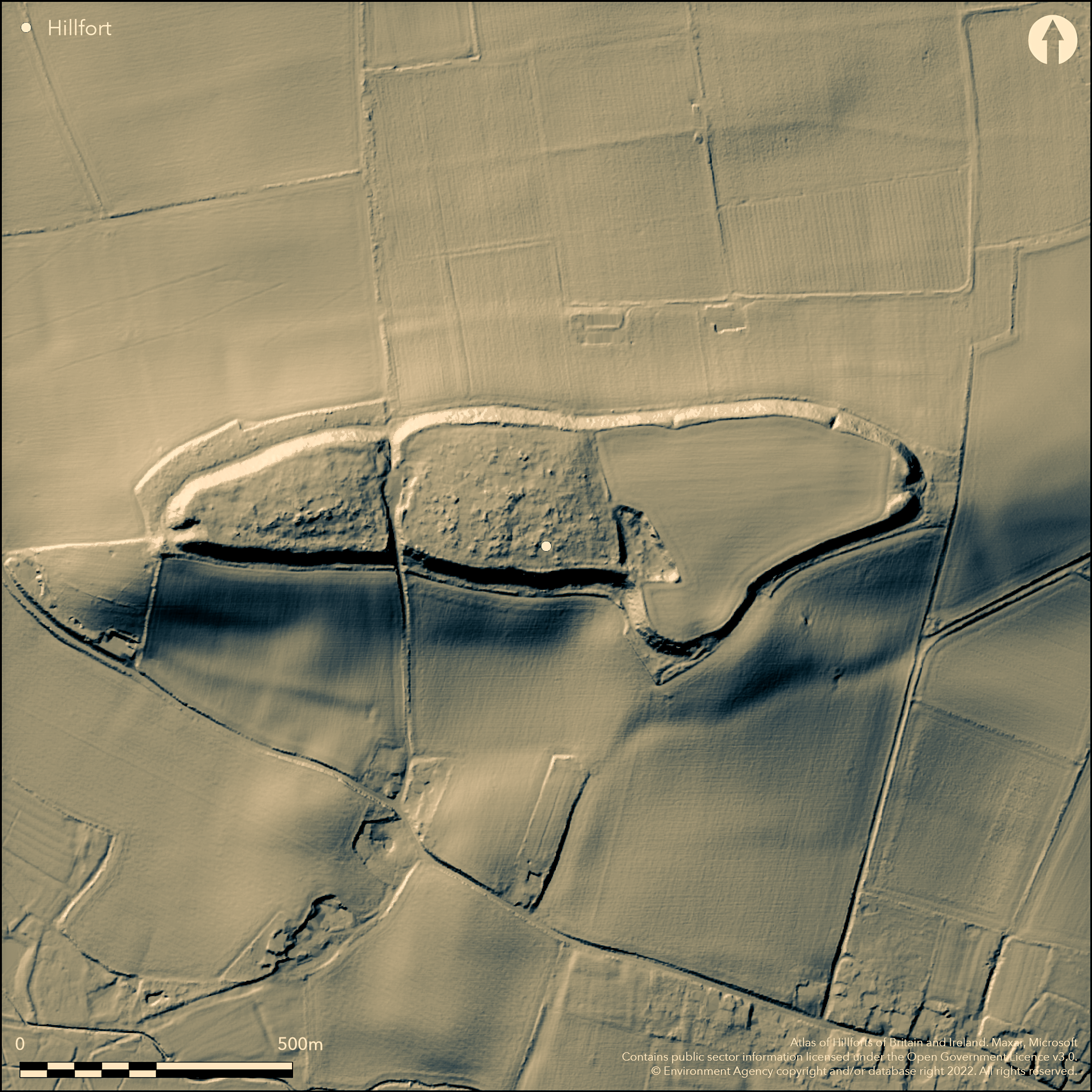
LiDAR 1m DTM Hillshade
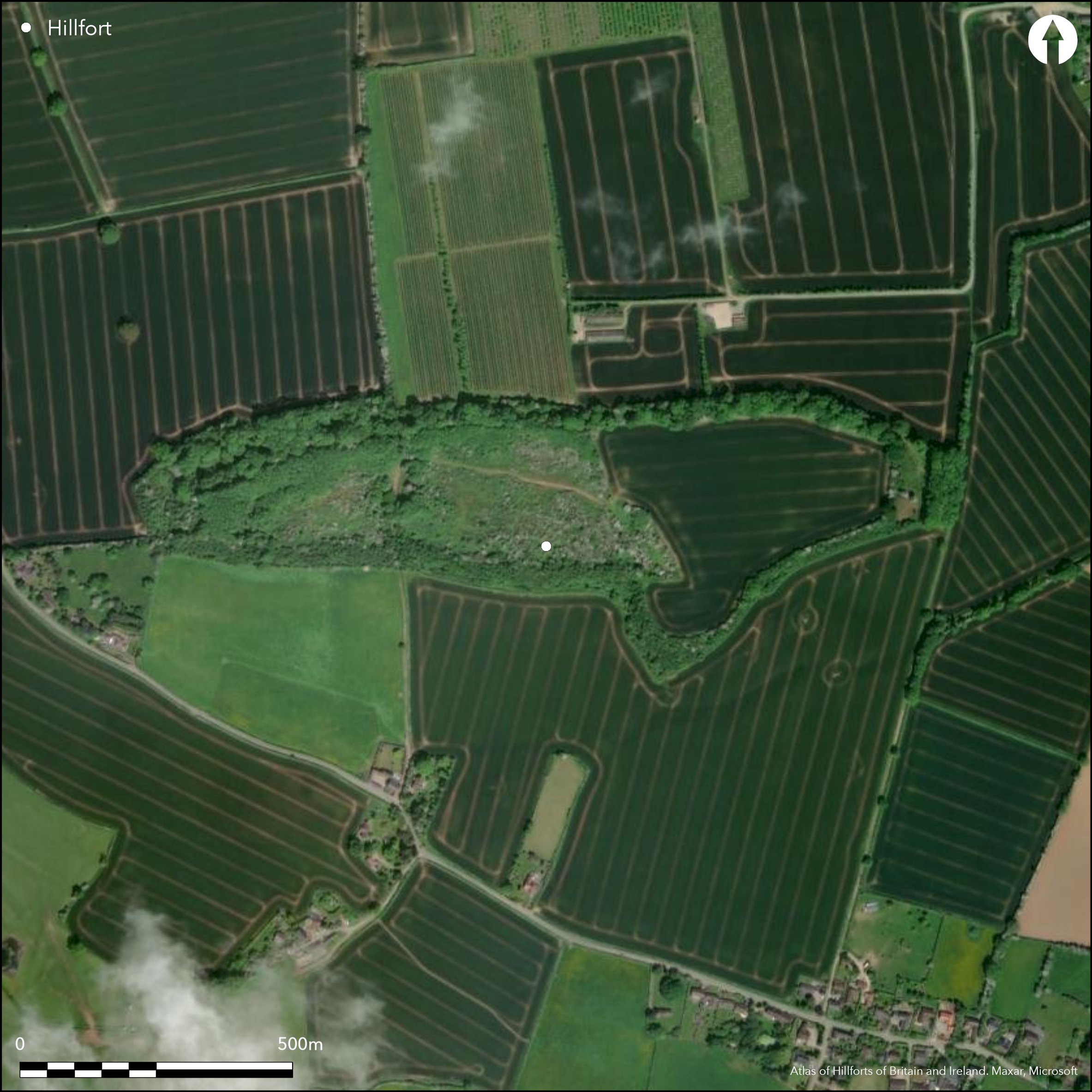
Satellite Imagery
LiDAR 1m DTM Hillshade
Satellite Imagery
Scroll left/right to view further images.
HER: Herefordshire MHE415 (912)
NMR: SO 54 NW 1 (110452)
SM: 1001747
NGR: SO 525463
X: 352520 Y: 246358 (OSGB36)
Visited by Leland in the 16th century, when a possible castle was visible, what was once a fine, large, partial contour hillfort, with single bank and ditch, now eroded to a steep scarp with a terrace at its foot, emphasising the monumentality of the site. Internal area 11.5ha. Initial occupation probably under the existing bank and protected by a palisade. Salvage excavations by Kenyon between 1948-51 suggested that the first rampart was built up from a v-shaped ditch of 32m width and 15m high, and burial found in the make-up. After an interval, the bank was raised during the c. 1st century BC and a hurried and incomplete fortification followed. The fort was attacked and captured by the Romans c. AD 75 - many defenders killed and bodies thrown into the ditch; some decapitated. Very many finds of human and animal bone, Iron Age and Roman pottery, loom weights, spindle whorls and weaving combs and cheek-pieces of bridles, glass objects and iron and bronze working in general, all show that here was a thriving farming community. The first occupation was early in the 1st century BC, and lasted until the 4th century AD. The site has been poorly treated, large-scale quarrying beginning in 1935 and c. 25% of the W end has been quarried away to a depth of 6m and subsequently used as a toxic waste dump. Antiquarian visits and interest. On 1st Ed OS map 1887.
Citizen Science: ✗
Reliability of Data: Confirmed
Reliability of Interpretation: Confirmed
X: -299984 Y: 6820666 (EPSG: 3857)
Longitude: -2.6947994027127242 Latitude: 52.11345916278155 (EPSG:4326)
Country: England
Current County or Unitary Authority: Herefordshire
Historic County: Herefordshire
Current Parish/Community/Council/Townland: Sutton
A quarter of the W part of the interior destroyed by quarrying, beginning in 1935 to a depth of 6m and then used as a toxic waste dump, finishing in the 1980's. The ramparts are eroded and the site is continuing to deteriorate. On Heritage at Risk Register (2015).
| Extant | ✓ |
| Cropmark | ✗ |
| Likely Destroyed | ✓ |
About 25% of the W part of the site has been used as a quarry and toxic waste dump. The remaining 75% is down to pasture.
| Woodland | ✗ |
| Commercial Forestry Plantation | ✗ |
| Parkland | ✗ |
| Pasture (Grazing) | ✓ |
| Arable | ✗ |
| Scrub/Bracken | ✗ |
| Bare Outcrop | ✗ |
| Heather/Moorland | ✗ |
| Heath | ✗ |
| Built-up | ✗ |
| Coastal Grassland | ✗ |
| Other | ✓ |
The elongated E to W, site follows the 100m contour to the E dipping to the W at the W end. Located on a low, but prominent, hill overlooking the River Lugg.
| Contour Fort | ✗ |
| Partial Contour Fort | ✓ |
| Promontory Fort | ✗ |
| Hillslope Fort | ✗ |
| Level Terrain Fort | ✗ |
| Marsh Fort | ✗ |
| Multiple Enclosure Fort | ✗ |
| Hilltop | ✓ |
| Coastal Promontory | ✗ |
| Inland Promontory | ✗ |
| Valley Bottom | ✗ |
| Knoll/Hillock/Outcrop | ✗ |
| Ridge | ✗ |
| Cliff/Plateau-edge/Scarp | ✗ |
| Hillslope | ✗ |
| Lowland | ✗ |
| Spur | ✗ |
Dominant Topographic Feature: Low, but prominent, hill.
| North | ✗ |
| Northeast | ✗ |
| East | ✗ |
| Southeast | ✗ |
| South | ✗ |
| Southwest | ✗ |
| West | ✓ |
| Northwest | ✗ |
| Level | ✓ |
Altitude: 100.0m
N/A
The first occupation was early in the 1st century BC, and lasted until the 4th century AD. Evidence comes from excavation and artefacts, particularly pottery.
Reliability: B - Medium
| Pre 1200BC | ✗ |
| 1200BC - 800BC | ✗ |
| 800BC - 400BC | ✗ |
| 400BC - AD50 | ✓ |
| AD50 - AD400 | ✓ |
| AD400 - AD 800 | ✗ |
| Post AD800 | ✗ |
| Unknown | ✗ |
| Pre Hillfort: | None |
| Post Hillfort: | None |
| Artefactual: | Iron Age pottery with Romano-British ware in great abundance. Metal-ware and Five Roman coins. |
Visited by Leland in 16th century. In Aubrey's Monumenta Britannica (1665-1693). On 1st Ed OS map 1887. Salvage excavations were undertaken by K.M. Kenyon between 1948-51, with the excavation report published in 1954. The site was very rich in artefacts; particularly late Iron Age and Roman pottery. Herefordshire CC survey 2012.
| 1st Identified Map Depiction (1887): | OS map |
| Other (2012): | Survey by Herefordshire CC. |
| Other (None): | Aubrey's Monumenta Britannica. |
| 1st Identified Written Reference (None): | Visited by Leland. |
| Excavation (None): | Salvage excavations by Kenyon 1948-54. |
The use of the site as a toxic waste dump until the 1980's has precluded surface investigation and interpretation of any features in the interior. The site was particularly rich in finds, with much human and animal bone, including 24 human skeletons, Iron Age and Roman pottery, loom weights, spindle whorls and weaving combs and cheek-pieces of bridles, glass objects and iron and bronze working in general, all show that here was a thriving farming community.
Spring located 0.65 km outside the hillfort.
| None | ✓ |
| Spring | ✗ |
| Stream | ✗ |
| Pool | ✗ |
| Flush | ✗ |
| Well | ✗ |
| Other | ✗ |
The use of the site as a quarry and toxic waste dump until the 1980's has precluded surface investigation and interpretation of any features in the interior.
| No Known Features | ✓ |
| Round Stone Structures | ✗ |
| Rectangular Stone Structures | ✗ |
| Curvilinear Platforms | ✗ |
| Other Roundhouse Evidence | ✗ |
| Pits | ✗ |
| Quarry Hollows | ✗ |
| Other | ✗ |
Possible that quarry hollows were used as dwelling sites.
| No Known Excavation | ✗ |
| Pits | ✗ |
| Postholes | ✗ |
| Roundhouses | ✗ |
| Rectangular Structures | ✗ |
| Roads/Tracks | ✗ |
| Quarry Hollows | ✓ |
| Other | ✗ |
| Nothing Found | ✗ |
None
| No Known Geophysics | ✓ |
| Pits | ✗ |
| Roundhouses | ✗ |
| Rectangular Structures | ✗ |
| Roads/Tracks | ✗ |
| Quarry Hollows | ✗ |
| Other | ✗ |
| Nothing Found | ✗ |
The site was particularly rich in finds, with much human and animal bone, including 24 human skeletons, Iron Age and Romano-British pottery, loom weights, spindle whorls and weaving combs and cheek-pieces of bridles, glass objects and iron and bronze working in general, all show that here was a thriving farming community.
| No Known Finds | ✗ |
| Pottery | ✓ |
| Metal | ✓ |
| Metalworking | ✓ |
| Human Bones | ✓ |
| Animal Bones | ✓ |
| Lithics | ✓ |
| Environmental | ✗ |
| Other | ✓ |
None
| APs Not Checked | ✓ |
| None | ✗ |
| Roundhouses | ✗ |
| Rectangular Structures | ✗ |
| Pits | ✗ |
| Postholes | ✗ |
| Roads/Tracks | ✗ |
| Other | ✗ |
There are two entrances, at the E and W ends of the site, now damaged, and formerly inturned. The gaps to the N and S are modern. The entrance to the E has been badly affected by the toxic waste dump.
| 4: | The gaps to the N and S are modern. |
| 2: | There are two inturned entrances, at the E and W ends of the site, now damaged. |
Guard Chambers: ✗
Chevaux de Frise: ✗
| 1. In-turned (East): | Badly affected by the toxic waste dump. |
| 2. In-turned (West): | Shows inturns |
The single bank and ditch has been eroded to a steep scarp with a terrace at its foot emphasising the monumentality of the site. This surrounds the site as a degenerate steep scarp. Kenyon suggested that the first rampart was built up from a v-shaped ditch of 32m width and 15m high. Possible pre-rampart palisade.
| Area 1: | 11.5ha. |
| Total: | 11.5ha. |
Total Footprint Area: Noneha.
None
| ✗ | The rampart and ditch surrounds the site as a degenerate steep scarp. |
| ✓ | The rampart and ditch surrounds the site as a degenerate steep scarp, but badly affected by the toxic waste dump to the W. |
| NE Quadrant: | 1 |
| SE Quadrant: | 1 |
| SW Quadrant: | 1 |
| NW Quadrant: | 1 |
| Total: | 1 |
| Partial Univallate | ✗ |
| Univallate | ✓ |
| Partial Bivallate | ✗ |
| Bivallate | ✗ |
| Partial Multivallate | ✗ |
| Multivallate | ✗ |
| Unknown | ✗ |
| Partial Univallate | ✗ |
| Univallate | ✗ |
| Partial Bivallate | ✗ |
| Bivallate | ✗ |
| Partial Multivallate | ✗ |
| Multivallate | ✗ |
Initial occupation was probably under the existing bank and protected by a palisade. Possible counterscarp to be determined.
| None | ✗ |
| Earthen Bank | ✓ |
| Stone Wall | ✗ |
| Rubble | ✗ |
| Wall-walk | ✗ |
| Evidence of Timber | ✗ |
| Vitrification | ✗ |
| Other Burning | ✗ |
| Palisade | ✓ |
| Counter Scarp Bank | ✓ |
| Berm | ✗ |
| Unfinished | ✗ |
| Other | ✗ |
Pre-rampart timber palisade suggested by Kenyon as a result of posthole evidence.
| None | ✗ |
| Earthen Bank | ✓ |
| Stone Wall | ✗ |
| Murus Duplex | ✗ |
| Timber-framed | ✗ |
| Timber-laced | ✗ |
| Vitrification | ✗ |
| Other Burning | ✗ |
| Palisade | ✓ |
| Counter Scarp Bank | ✗ |
| Berm | ✗ |
| Unfinished | ✗ |
| No Known Excavation | ✗ |
| Other | ✗ |
| ✗ | None |
| ✓ | Ditch surrounds the site. Excavation suggested that the first rampart was built up from a v-shaped ditch of 32m width and 15m in height. |
Number of Ditches: 1
| ✗ | None |
Dorling, P. and Wigley, A. 2012. Assessment of the archaeological and conservation status of major later prehistoric enclosures in Herefordshire and Shropshire, EH PNUM, Version 3.2, Hereford and Shrewsbury: Herefordshire Council/Shropshire Council.
Kenyon, K.M. 1954. The excavations at Sutton Walls, Herefordshire, 1948-51, Archaeol J, 110, 1-87.
Page, W. ed. 1908. The Victoria County History of the County of Herefordshire, 1, 220, London: St Catherine Press.
RCHME 1931-34. An Inventory of the Historical Monuments in Herefordshire, 2, (E), 181-82, 33, London: HMSO.
Atlas of Hillforts:
Wikidata:
This work is licensed under CC BY-SA 4.0![]()
![]()
![]() and should be cited as:
and should be cited as:
Lock, Gary and Ralston, Ian. 2024. Atlas of Hillforts of Britain and Ireland. Available at: https://hillforts.arch.ox.ac.uk
Document Version 1.1