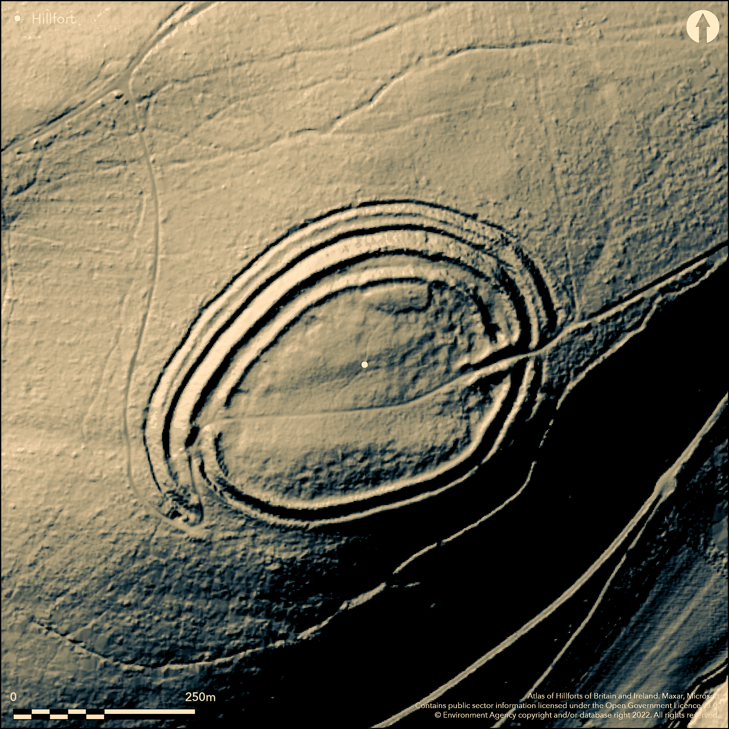
LiDAR 1m DTM Hillshade
Satellite Imagery
LiDAR 1m DTM Hillshade
Satellite Imagery
Scroll left/right to view further images.
HER: Shropshire 149 (None)
NMR: SO 38 SW 3 (107285)
SM: 1010320
NGR: SO 327837
X: 332743 Y: 283738 (OSGB36)
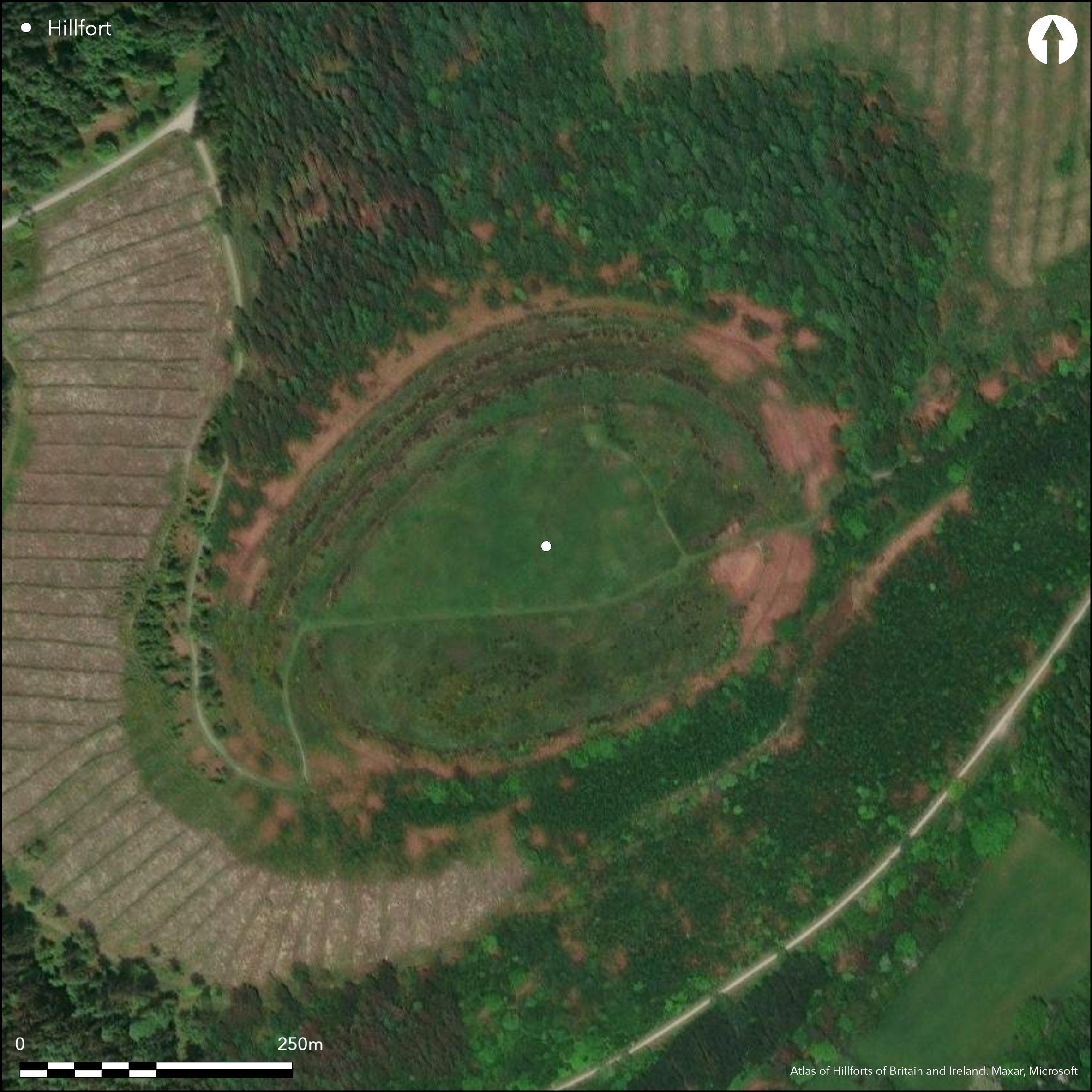
Well preserved and accessible, partial contour hillfort located above valley of the River Clun to S, valley of River Kemp to N and confluence of Rivers Clun and Unk to SW. The site dominates the landscape in all directions in an area of prominent hillforts. Called by Watson (2002, 21) one of the finest hillforts in Britain. Roughly oval in shape, with internal area c. 2,2ha, with up to five massive ramparts up to 7m in height on the N side where the slopes are less steep; each with an outer ditch. Possible quarry scoops in the interior of the innermost rampart. On the S and E sides there are two ramparts with medial ditch where the slopes are steeper. Perhaps the most impressive feature of the hillfort are the two original entrances; opposite to each other on the NE and SW. The former is a classic example of an inturned entrance, the inner rampart and the second rampart on the N side turning inwards on either side to create a passageway 40m in length. The SW entrance is 'staggered' with the N ramparts overlapping those curving from the S to give a 90m overlooked passageway. Public access and managed and interpreted by Forestry Commission. Rough pasture interior and banks. Undated. On 1st Ed OS map (1885-1900).
Citizen Science: ✗
Reliability of Data: Confirmed
Reliability of Interpretation: Confirmed
X: -332961 Y: 6881432 (EPSG: 3857)
Longitude: -2.9910400660952425 Latitude: 52.447417015759406 (EPSG:4326)
Country: England
Current County or Unitary Authority: Shropshire
Historic County: Shropshire
Current Parish/Community/Council/Townland: Lydbury North
Tree cover removed by storm and clearance by 1981, now pasture and well preserved, Some visitor erosion. FC management of regenerating scrub, saplings and bracken.
| Extant | ✓ |
| Cropmark | ✗ |
| Likely Destroyed | ✗ |
Managed grassland. Slopes below tree covered. Possible warrener's lodge platform.
| Woodland | ✗ |
| Commercial Forestry Plantation | ✗ |
| Parkland | ✗ |
| Pasture (Grazing) | ✓ |
| Arable | ✗ |
| Scrub/Bracken | ✓ |
| Bare Outcrop | ✗ |
| Heather/Moorland | ✗ |
| Heath | ✗ |
| Built-up | ✗ |
| Coastal Grassland | ✗ |
| Other | ✓ |
Interior slopes gently to the SW corner. Sited on Sunnyhill above the valley of the River Clun to the S, the valley of the River Kemp to the N and the confluence of the Rivers Clun and Unk to the SW.
| Contour Fort | ✗ |
| Partial Contour Fort | ✓ |
| Promontory Fort | ✗ |
| Hillslope Fort | ✗ |
| Level Terrain Fort | ✗ |
| Marsh Fort | ✗ |
| Multiple Enclosure Fort | ✗ |
| Hilltop | ✓ |
| Coastal Promontory | ✗ |
| Inland Promontory | ✗ |
| Valley Bottom | ✗ |
| Knoll/Hillock/Outcrop | ✗ |
| Ridge | ✗ |
| Cliff/Plateau-edge/Scarp | ✗ |
| Hillslope | ✗ |
| Lowland | ✗ |
| Spur | ✗ |
Dominant Topographic Feature: Hill summit
| North | ✗ |
| Northeast | ✗ |
| East | ✗ |
| Southeast | ✗ |
| South | ✗ |
| Southwest | ✓ |
| West | ✗ |
| Northwest | ✗ |
| Level | ✗ |
Altitude: 392.0m
N/A
None
Reliability: D - None
| Pre 1200BC | ✗ |
| 1200BC - 800BC | ✗ |
| 800BC - 400BC | ✗ |
| 400BC - AD50 | ✗ |
| AD50 - AD400 | ✗ |
| AD400 - AD 800 | ✗ |
| Post AD800 | ✗ |
| Unknown | ✓ |
| Pre Hillfort: | Possible. Flint axe found. |
| Post Hillfort: | Pillow mound and possible post-medieval platform (possible warrener's lodge). |
On 1st Ed OS map (1885-1900). Field observation Ordnance Survey 1973. Field observation Shropshire CC 1976, 1981. Field observation English Heritage 1985. Air Photograph Interpretation RCHME: Marches Uplands NMP 1993-2000. Shropshire Council survey 2012.
| Other (1968): | Visit by Hillfort Study Group |
| Other (1973): | Field observation OS. |
| Other (1985): | Field observation EH. |
| Other (2009): | Visited by Hillfort Study Group |
| Other (2012): | Shropshire Council survey 2012. |
| Other (None): | Field observation Shropshire CC. |
| 1st Identified Map Depiction (None): | 1st Ed OS |
| Other (None): | Air Photograph Interpretation RCHME: Marches Uplands NMP. |
Pillow mound and possible post-medieval platform (possible warrener's lodge). Stone quarry on the N side of the interior. Possible quarry scoops in the interior of the innermost rampart. Flint axe.
Springs located 0.3 km outside the hillfort.
| None | ✓ |
| Spring | ✗ |
| Stream | ✗ |
| Pool | ✗ |
| Flush | ✗ |
| Well | ✗ |
| Other | ✗ |
Pillow mound and possible post-medieval platform (possible warrener's lodge). Possible quarry hollows in the interior of the innermost rampart.
| No Known Features | ✗ |
| Round Stone Structures | ✗ |
| Rectangular Stone Structures | ✗ |
| Curvilinear Platforms | ✗ |
| Other Roundhouse Evidence | ✗ |
| Pits | ✗ |
| Quarry Hollows | ✓ |
| Other | ✓ |
None
| No Known Excavation | ✓ |
| Pits | ✗ |
| Postholes | ✗ |
| Roundhouses | ✗ |
| Rectangular Structures | ✗ |
| Roads/Tracks | ✗ |
| Quarry Hollows | ✗ |
| Other | ✗ |
| Nothing Found | ✗ |
None
| No Known Geophysics | ✓ |
| Pits | ✗ |
| Roundhouses | ✗ |
| Rectangular Structures | ✗ |
| Roads/Tracks | ✗ |
| Quarry Hollows | ✗ |
| Other | ✗ |
| Nothing Found | ✗ |
Flint axe.
| No Known Finds | ✗ |
| Pottery | ✗ |
| Metal | ✗ |
| Metalworking | ✗ |
| Human Bones | ✗ |
| Animal Bones | ✗ |
| Lithics | ✓ |
| Environmental | ✗ |
| Other | ✗ |
None
| APs Not Checked | ✓ |
| None | ✗ |
| Roundhouses | ✗ |
| Rectangular Structures | ✗ |
| Pits | ✗ |
| Postholes | ✗ |
| Roads/Tracks | ✗ |
| Other | ✗ |
The NE entrance s a classic example of an inturned entrance, the inner rampart and the second rampart on the N side turning inwards on either side to create a passageway 40m in length. The SW entrance is 'staggered' with the N ramparts overlapping those curving from the S to give a 90m overlooked passageway.
| 2: | No modern gaps recorded. |
| 2: | Fine well preserved entrances to the NE and SW. Former inturned with narrow 40 m passage. SW entrance staggered with 90 m passageway. |
Guard Chambers: ✗
Chevaux de Frise: ✗
| 1. In-turned (North east): | A classic example of an inturned entrance, the inner rampart and the second rampart on the N side turning inwards on either side to create a passageway 40m in length. |
| 1. Passage-way/Corridor (North east): | Passageway 40m in length. |
| 2. Over-lapping (South west): | A 'staggered' entrance with the N ramparts overlapping those curving from the S to give a 90m overlooked passageway. |
| 2. Passage-way/Corridor (South west): | 90m overlooked passageway. |
Roughly oval in shape, with up to five massive ramparts up to 7m in height on the N side where the slopes are less steep; each with an outer ditch. Possible quarry scoops in the interior of the innermost rampart. On the S and E sides there are two ramparts with medial ditch where the slopes are steeper.
| Area 1: | 2.2ha. |
| Total: | 2.2ha. |
Total Footprint Area: Noneha.
None
| ✗ | None |
| ✓ | Superb circuit of up to five ramparts. |
| NE Quadrant: | 5 |
| SE Quadrant: | 2 |
| SW Quadrant: | 2 |
| NW Quadrant: | 5 |
| Total: | 5 |
| Partial Univallate | ✗ |
| Univallate | ✗ |
| Partial Bivallate | ✓ |
| Bivallate | ✗ |
| Partial Multivallate | ✓ |
| Multivallate | ✗ |
| Unknown | ✗ |
| Partial Univallate | ✗ |
| Univallate | ✗ |
| Partial Bivallate | ✗ |
| Bivallate | ✗ |
| Partial Multivallate | ✗ |
| Multivallate | ✗ |
Possible earthen bank.
| None | ✗ |
| Earthen Bank | ✓ |
| Stone Wall | ✗ |
| Rubble | ✗ |
| Wall-walk | ✗ |
| Evidence of Timber | ✗ |
| Vitrification | ✗ |
| Other Burning | ✗ |
| Palisade | ✗ |
| Counter Scarp Bank | ✗ |
| Berm | ✗ |
| Unfinished | ✗ |
| Other | ✗ |
None
| None | ✗ |
| Earthen Bank | ✗ |
| Stone Wall | ✗ |
| Murus Duplex | ✗ |
| Timber-framed | ✗ |
| Timber-laced | ✗ |
| Vitrification | ✗ |
| Other Burning | ✗ |
| Palisade | ✗ |
| Counter Scarp Bank | ✗ |
| Berm | ✗ |
| Unfinished | ✗ |
| No Known Excavation | ✓ |
| Other | ✗ |
| ✗ | None |
| ✓ | Each of the up to five ramparts has an outer ditch. |
Number of Ditches: 5
| ✗ | None |
Dorling, P. and Wigley, A. 2012. Assessment of the archaeological and conservation status of major later prehistoric enclosures in Herefordshire and Shropshire, EH PNUM, Version 3.2, Hereford and Shrewsbury: Herefordshire Council/Shropshire Council.
Page, W. ed. 1908. Victoria County History of Shropshire, 1, 364-65, Institute of Historical Research.
Watson 2002. Shropshire an archaeological guide, 21-2, aerial photo. Shrewsbury: Shropshire Books.
Atlas of Hillforts:
Wikidata:
This work is licensed under CC BY-SA 4.0![]()
![]()
![]() and should be cited as:
and should be cited as:
Lock, Gary and Ralston, Ian. 2024. Atlas of Hillforts of Britain and Ireland. Available at: https://hillforts.arch.ox.ac.uk
Document Version 1.1