LiDAR 1m DTM Hillshade
Satellite Imagery
LiDAR 1m DTM Hillshade
Satellite Imagery
Scroll left/right to view further images.
HER: Shropshire 226 (None)
NMR: SO 49 NE 11 (106751)
SM: 1021067
NGR: SO 477952
X: 347728 Y: 295280 (OSGB36)
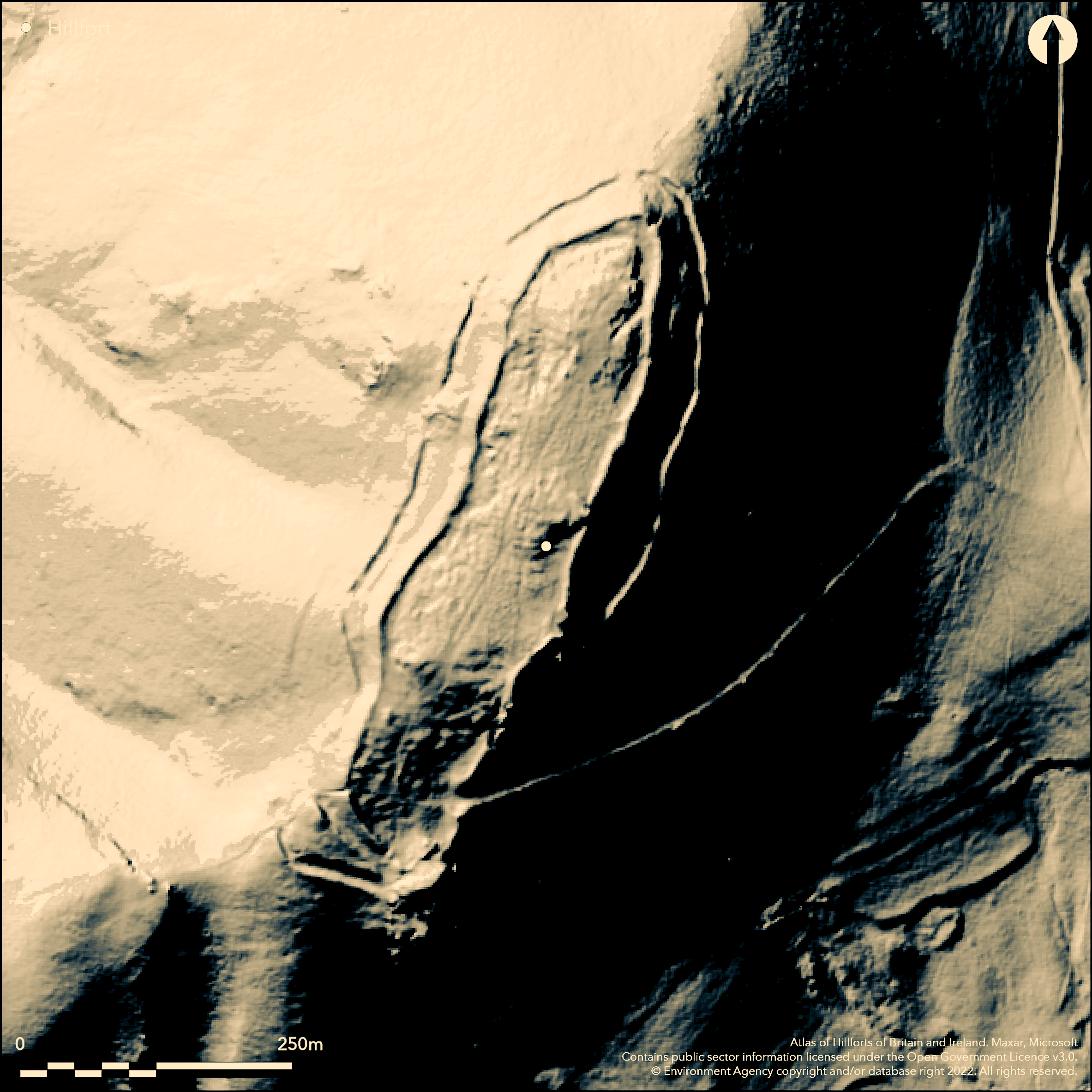
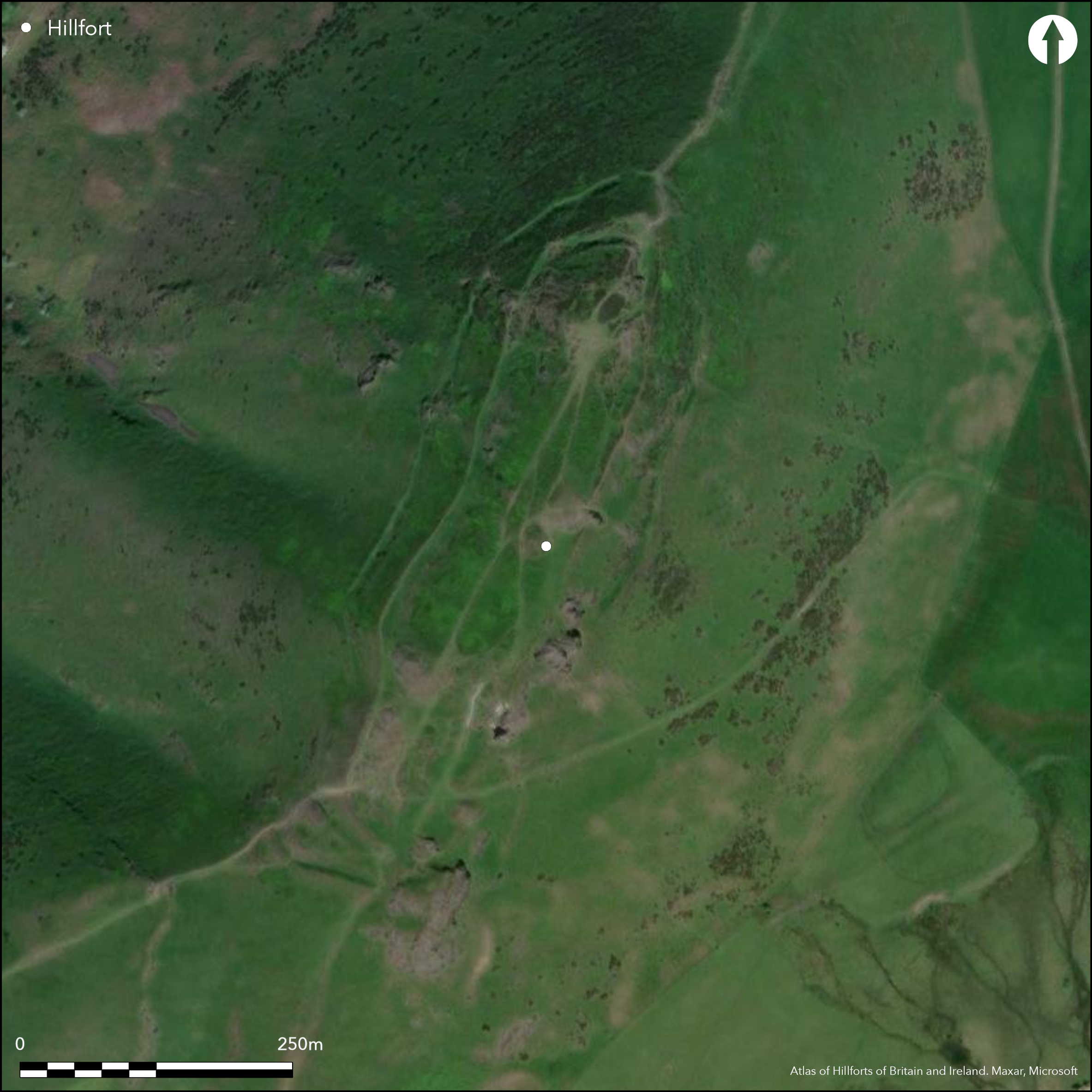
Fine and prominent craggy hillfort on steep ridge of Caer Caradoc Hill. Commanding site. Precipitous slopes, apart from at the NE and SW sides. Measures c. 380m long NE-SW and 70m across falling 30m from N to S, with internal area 2.6ha. Strategically site to command the pass through the Church Stretton valley. Main inner scarped rampart (formerly a stone wall?) follows the crest of the slopes and uses natural rock on SE. 25m from this is an outer additional bank for most of the circuit constructed from an internal quarry ditch. Third bank on shallower S side. Inner rampart 12m wide and up to 1.7 min height. The outer rampart is 10m below around the N part of the site, 10m wide and 0.5m high and with an internal ditch 0.5m deep. The ditch reappears at the SW end with the third rampart to the SW. Fine inturned entrance on the E side with an engineered terraceway running obliquely down the hillside and probably forming the access route to the site, as it does today. Recessed guard chamber on S side. Small terraces and building platforms visible in the SE. Interior divisions may mark zoning in the interior. Good example of a hillfort commanding a pass through the hillls. Few investigations for such a major site. Heath and rough upland grazing. Undated. On 1st Ed OS map (1885-1900).
Citizen Science: ✗
Reliability of Data: Confirmed
Reliability of Interpretation: Confirmed
X: -308622 Y: 6900705 (EPSG: 3857)
Longitude: -2.7723959676848424 Latitude: 52.5528133192448 (EPSG:4326)
Country: England
Current County or Unitary Authority: Shropshire
Historic County: Shropshire
Current Parish/Community/Council/Townland: Church Stretton
Popular site for recreation with path erosion on N and S ramparts and deep erosion scar below rock outcrops N of the entrance, but generally on good condition.
| Extant | ✓ |
| Cropmark | ✗ |
| Likely Destroyed | ✗ |
Hill top heath and rough grazing with bare rocky outcrops. SSSI.
| Woodland | ✗ |
| Commercial Forestry Plantation | ✗ |
| Parkland | ✗ |
| Pasture (Grazing) | ✓ |
| Arable | ✗ |
| Scrub/Bracken | ✗ |
| Bare Outcrop | ✗ |
| Heather/Moorland | ✓ |
| Heath | ✗ |
| Built-up | ✗ |
| Coastal Grassland | ✗ |
| Other | ✗ |
High, prominent and craggy partial contour fort, some 380m long, and falling 30m from N to S and located on the steep ridge of Caer Caradoc Hill.
| Contour Fort | ✗ |
| Partial Contour Fort | ✓ |
| Promontory Fort | ✗ |
| Hillslope Fort | ✗ |
| Level Terrain Fort | ✗ |
| Marsh Fort | ✗ |
| Multiple Enclosure Fort | ✗ |
| Hilltop | ✓ |
| Coastal Promontory | ✗ |
| Inland Promontory | ✗ |
| Valley Bottom | ✗ |
| Knoll/Hillock/Outcrop | ✗ |
| Ridge | ✓ |
| Cliff/Plateau-edge/Scarp | ✗ |
| Hillslope | ✗ |
| Lowland | ✗ |
| Spur | ✗ |
Dominant Topographic Feature: Steep craggy hill.
| North | ✗ |
| Northeast | ✗ |
| East | ✗ |
| Southeast | ✗ |
| South | ✓ |
| Southwest | ✗ |
| West | ✗ |
| Northwest | ✗ |
| Level | ✓ |
Altitude: 459.0m
N/A
None
Reliability: D - None
| Pre 1200BC | ✗ |
| 1200BC - 800BC | ✗ |
| 800BC - 400BC | ✗ |
| 400BC - AD50 | ✗ |
| AD50 - AD400 | ✗ |
| AD400 - AD 800 | ✗ |
| Post AD800 | ✗ |
| Unknown | ✓ |
| Pre Hillfort: | None |
| Post Hillfort: | None |
Drawn by Elias Ashmole (1662). On 1st Ed OS map (1885-1900). Field observation Ordnance Survey 1972. Field observation English Heritage 1985. Air Photograph Interpretation RCHME: Marches Uplands NMP 1993-2000. Shropshire Council survey 2012
| 1st Identified Written Reference (1662): | Drawn by Elias Ashmole. |
| Other (1968): | Visit by Hillfort Study Group |
| Other (1972): | Field observation OS. |
| Other (1985): | Field observation EH. |
| Other (2009): | Visited by Hillfort Study Group |
| Other (2012): | Shropshire Council survey. |
| 1st Identified Map Depiction (None): | 1st Ed OS map |
| Other (None): | Air Photograph Interpretation RCHME: Marches Uplands NMP. |
Small terraces and building platforms visible in the SE. Interior divisions may mark zoning in the interior.
Spring in the NW interior of the site.
| None | ✗ |
| Spring | ✓ |
| Stream | ✗ |
| Pool | ✗ |
| Flush | ✗ |
| Well | ✗ |
| Other | ✗ |
Small terraces and building platforms visible in the SE. Interior divisions may mark zoning in the interior.
| No Known Features | ✗ |
| Round Stone Structures | ✗ |
| Rectangular Stone Structures | ✗ |
| Curvilinear Platforms | ✓ |
| Other Roundhouse Evidence | ✗ |
| Pits | ✗ |
| Quarry Hollows | ✗ |
| Other | ✓ |
None
| No Known Excavation | ✓ |
| Pits | ✗ |
| Postholes | ✗ |
| Roundhouses | ✗ |
| Rectangular Structures | ✗ |
| Roads/Tracks | ✗ |
| Quarry Hollows | ✗ |
| Other | ✗ |
| Nothing Found | ✗ |
None
| No Known Geophysics | ✓ |
| Pits | ✗ |
| Roundhouses | ✗ |
| Rectangular Structures | ✗ |
| Roads/Tracks | ✗ |
| Quarry Hollows | ✗ |
| Other | ✗ |
| Nothing Found | ✗ |
None
| No Known Finds | ✓ |
| Pottery | ✗ |
| Metal | ✗ |
| Metalworking | ✗ |
| Human Bones | ✗ |
| Animal Bones | ✗ |
| Lithics | ✗ |
| Environmental | ✗ |
| Other | ✗ |
None
| APs Not Checked | ✓ |
| None | ✗ |
| Roundhouses | ✗ |
| Rectangular Structures | ✗ |
| Pits | ✗ |
| Postholes | ✗ |
| Roads/Tracks | ✗ |
| Other | ✗ |
Fine inturned entrance on the E side with an engineered terraceway running for 300m obliquely down the hillside and probably forming the access route to the site, as it does today. Recessed guard chamber on S side.
| 1: | No modern gaps in evidence. |
| 2: | One original entrance on the E, with recessed guard chamber on S side. Probable original terraced trackway decends 300m downslope. |
Guard Chambers: ✓
Chevaux de Frise: ✗
| 1. In-turned (East): | Fine inturned entrance with terraceway down hillside. |
| 1. Oblique (East): | Engineered terraceway runs obliquely down hillside, probably forming access route to site, as it does today. |
| 1. Recesses/Guard Chambers (East): | Recessed guard chamber on S side. |
Main inner scarped rampart (formerly a stone wall?) follows the crest of the slopes and uses natural rock on the SE. 25 m from this is an outer additional bank for most of the circuit constructed from an internal quarry ditch. Third defensive bank on shallower S side. The inner rampart is 12 m wide and up to 1.7 in height, enclosing an area 375 m by 70 m. The outer rampart is 10 m below around the N part of the site, 10 m wide and o.5 m high and with an internal ditch 0.5 m deep. The ditch reappears at the SW end with the third rampart to the SW.
| Area 1: | 2.6ha. |
| Total: | 2.6ha. |
Total Footprint Area: Noneha.
Main inner scarped rampart (formerly a stone wall?) follows the crest of the slopes and uses natural rock on the south-east. 25 m from this is an outer additional bank for most of the circuit constructed from an internal quarry ditch. Third defensive bank on shallower southern side. The inner rampart is 12 m wide and up to 1.7 in height, enclosing an area 375 m x 70 m. The outer rampart is 10 m below around the N part of the site, 10 m wide and o.5 m high and with an internal ditch 0.5 m deep. The ditch reappears at the SW end with the tird rampart to the SW.
| ✗ | None |
| ✓ | The number of ramparts vary around the circuit. |
| NE Quadrant: | 2 |
| SE Quadrant: | 3 |
| SW Quadrant: | 3 |
| NW Quadrant: | 2 |
| Total: | 3 |
| Partial Univallate | ✗ |
| Univallate | ✗ |
| Partial Bivallate | ✓ |
| Bivallate | ✗ |
| Partial Multivallate | ✓ |
| Multivallate | ✗ |
| Unknown | ✗ |
| Partial Univallate | ✗ |
| Univallate | ✗ |
| Partial Bivallate | ✗ |
| Bivallate | ✗ |
| Partial Multivallate | ✗ |
| Multivallate | ✗ |
Main inner scarped rampart formerly a stone wall?
| None | ✗ |
| Earthen Bank | ✓ |
| Stone Wall | ✓ |
| Rubble | ✗ |
| Wall-walk | ✗ |
| Evidence of Timber | ✗ |
| Vitrification | ✗ |
| Other Burning | ✗ |
| Palisade | ✗ |
| Counter Scarp Bank | ✗ |
| Berm | ✗ |
| Unfinished | ✗ |
| Other | ✗ |
None
| None | ✗ |
| Earthen Bank | ✗ |
| Stone Wall | ✗ |
| Murus Duplex | ✗ |
| Timber-framed | ✗ |
| Timber-laced | ✗ |
| Vitrification | ✗ |
| Other Burning | ✗ |
| Palisade | ✗ |
| Counter Scarp Bank | ✗ |
| Berm | ✗ |
| Unfinished | ✗ |
| No Known Excavation | ✓ |
| Other | ✗ |
| ✗ | None |
| ✓ | Ditches variable throughout circuit. |
Number of Ditches: 2
| ✗ | None |
Dorling, P. and Wigley, A. 2012. Assessment of the archaeological and conservation status of major later prehistoric enclosures in Herefordshire and Shropshire, EH PNUM, Version 3.2, Hereford and Shrewsbury: Herefordshire Council/Shropshire Council.
Page, W. ed. 1908. Victoria County History of Shropshire,1, 361, Institute of Historical Research.
Watson, M. 2002. Shropshire an archaeological guide, 24-25 photo, Shrewsbury: Shropshire Books.
Atlas of Hillforts:
Wikidata:
This work is licensed under CC BY-SA 4.0![]()
![]()
![]() and should be cited as:
and should be cited as:
Lock, Gary and Ralston, Ian. 2024. Atlas of Hillforts of Britain and Ireland. Available at: https://hillforts.arch.ox.ac.uk
Document Version 1.1