LiDAR 1m DTM Hillshade
Satellite Imagery
LiDAR 1m DTM Hillshade
Satellite Imagery
Scroll left/right to view further images.
HER: Shropshire 1218 (None)
NMR: SO 29 NE 8 (105532)
SM: 1006287
NGR: SO274959
X: 327415 Y: 295956 (OSGB36)
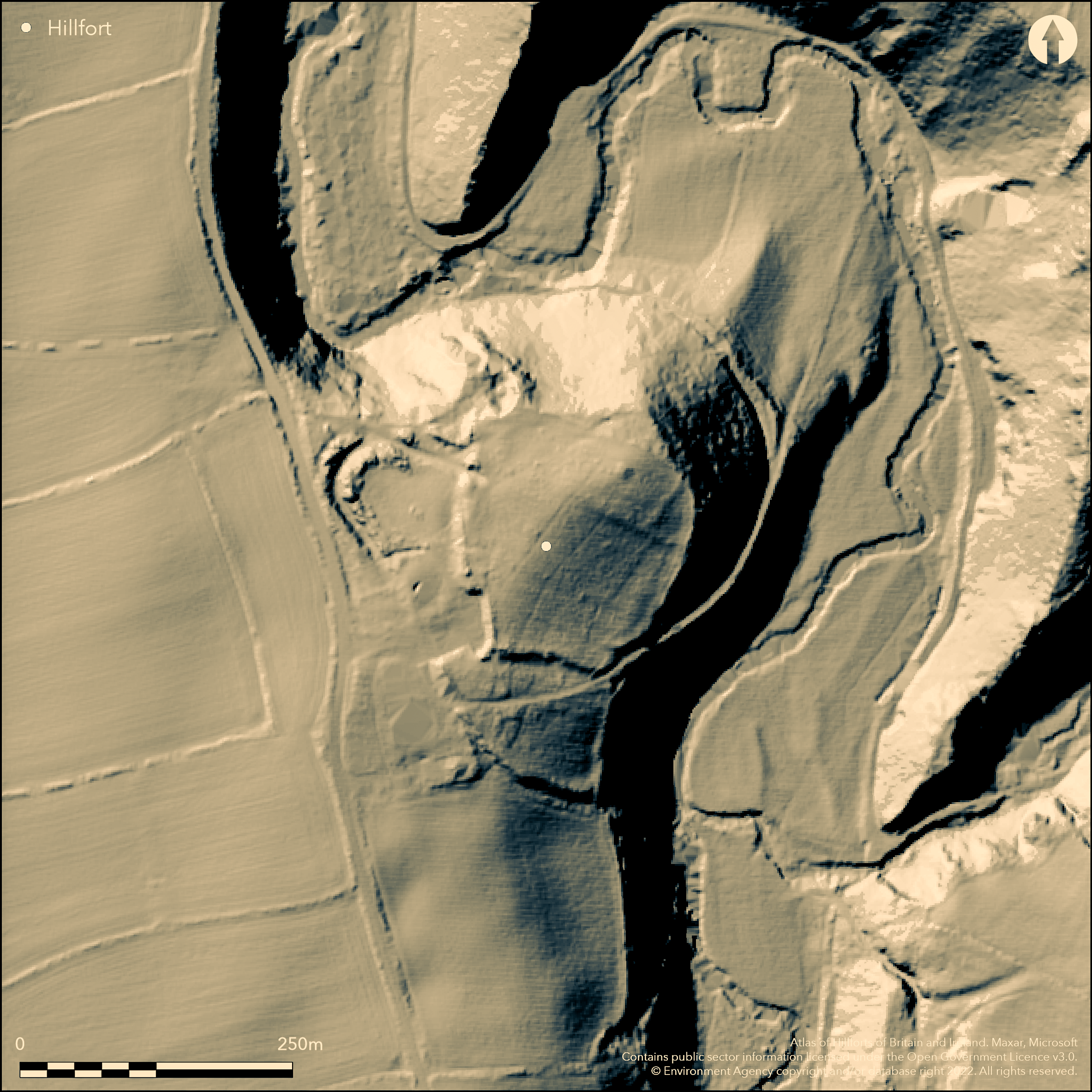
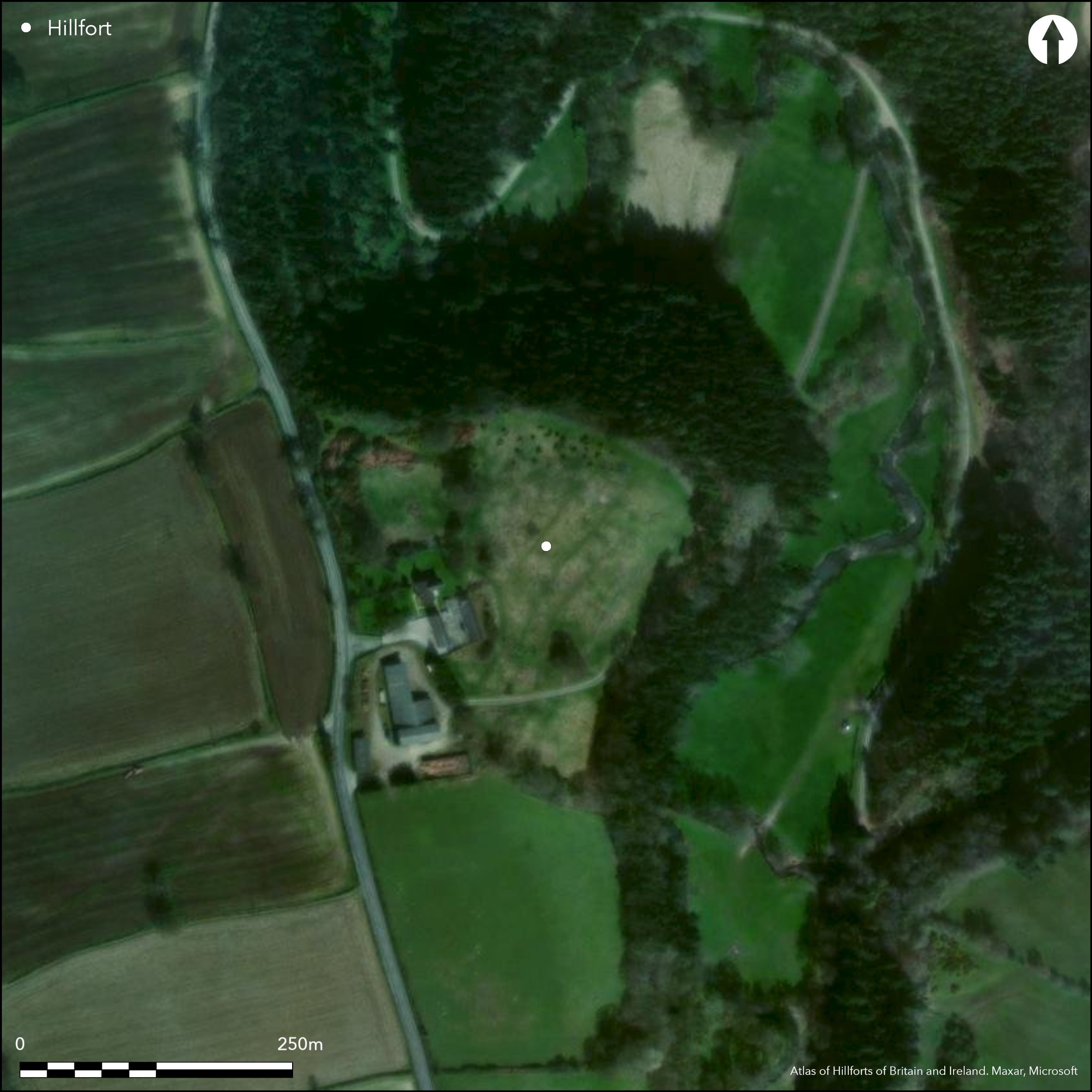
Partial contour hillfort sited on very steep wooded spur some 100m above bend of River Camlad and opposite to Caerbre hillfort (Atlas No 0051). Calcot often called 'Caerbre' and this has led to much confusion in past as to which hillfort is being referred to, as in the Victoria County History of 1908. Calcot, however, is located on W side of the river, and has been much eaten into on SW by buildings of Calcot Farm. Internal area c. 1.4ha. Slopes very steep to river on E and N and here ramparts form steep scarp, mutilated in places to S. Appears that hillfort of phased construction, Phase I being roughly rectangular site c. 130m by 120m and possibly enclosing c. 1.4ha, including the summit of the spur (now occupied by a water tank) and the gently sloping E slopes, and with a NW entrance. Later, in Phase II, site extended, seemingly with two lines of bank and ditch near to entrance, which may have been remodelled with passageway and inturns. Possible evidence of slight ditch to S. Site suffered greatly from farming operations and generally, but at the join between the S and E circuit, a modern field road has exposed the bank to be of dump construction of earth with a few stones. Undated. On 1st Ed OS map (1885-1900).
Citizen Science: ✗
Reliability of Data: Confirmed
Reliability of Interpretation: Confirmed
X: -341983 Y: 6901390 (EPSG: 3857)
Longitude: -3.072089003129565 Latitude: 52.556556216776116 (EPSG:4326)
Country: England
Current County or Unitary Authority: Shropshire
Historic County: Shropshire
Current Parish/Community/Council/Townland: Chirbury with Brompton
Much affected by Calcot Farm, which has destroyed areas to the SW in particular, but also on the E side. Modern field road cuts through the bank where the S and E circuits join. Water tank occupies the highest point.
| Extant | ✓ |
| Cropmark | ✗ |
| Likely Destroyed | ✓ |
Calcot Farm and pasture.
| Woodland | ✗ |
| Commercial Forestry Plantation | ✗ |
| Parkland | ✗ |
| Pasture (Grazing) | ✓ |
| Arable | ✗ |
| Scrub/Bracken | ✗ |
| Bare Outcrop | ✗ |
| Heather/Moorland | ✗ |
| Heath | ✗ |
| Built-up | ✓ |
| Coastal Grassland | ✗ |
| Other | ✓ |
Partial contour fort sited on a very steep wooded spur some 100m above a bend of the River Camlad and opposite to Caerbre.
| Contour Fort | ✗ |
| Partial Contour Fort | ✓ |
| Promontory Fort | ✗ |
| Hillslope Fort | ✗ |
| Level Terrain Fort | ✗ |
| Marsh Fort | ✗ |
| Multiple Enclosure Fort | ✗ |
| Hilltop | ✗ |
| Coastal Promontory | ✗ |
| Inland Promontory | ✗ |
| Valley Bottom | ✗ |
| Knoll/Hillock/Outcrop | ✗ |
| Ridge | ✗ |
| Cliff/Plateau-edge/Scarp | ✗ |
| Hillslope | ✗ |
| Lowland | ✗ |
| Spur | ✓ |
Dominant Topographic Feature: A very steep wooded spur some 100m above a bend of the River Camlad.
| North | ✗ |
| Northeast | ✗ |
| East | ✓ |
| Southeast | ✗ |
| South | ✗ |
| Southwest | ✗ |
| West | ✗ |
| Northwest | ✗ |
| Level | ✗ |
Altitude: 160.0m
N/A
None
Reliability: D - None
| Pre 1200BC | ✗ |
| 1200BC - 800BC | ✗ |
| 800BC - 400BC | ✗ |
| 400BC - AD50 | ✗ |
| AD50 - AD400 | ✗ |
| AD400 - AD 800 | ✗ |
| Post AD800 | ✗ |
| Unknown | ✓ |
| Pre Hillfort: | None |
| Post Hillfort: | None |
On 1st Ed OS map (1885-1900). Field observation Ordnance Survey 1973, 1979. Field observation Shropshire CC 1981. Field observation English heritage 1987. Air Photograph Interpretation RCHME: Marches Uplands NMP 1993-2000.
| Other (1981): | Field observation Shropshire CC. |
| Other (1987): | Field observation EH. |
| 1st Identified Map Depiction (None): | 1st Ed OS |
| Other (None): | Field observation OS. |
| Other (None): | Air Photograph Interpretation RCHME: Marches Uplands NMP. |
Possibly a few hut platforms.
River Camlad located 0.1km (100m below) outside the fort.
| None | ✓ |
| Spring | ✗ |
| Stream | ✗ |
| Pool | ✗ |
| Flush | ✗ |
| Well | ✗ |
| Other | ✗ |
Possibly a few hut platforms.
| No Known Features | ✗ |
| Round Stone Structures | ✗ |
| Rectangular Stone Structures | ✗ |
| Curvilinear Platforms | ✓ |
| Other Roundhouse Evidence | ✗ |
| Pits | ✗ |
| Quarry Hollows | ✗ |
| Other | ✗ |
None
| No Known Excavation | ✓ |
| Pits | ✗ |
| Postholes | ✗ |
| Roundhouses | ✗ |
| Rectangular Structures | ✗ |
| Roads/Tracks | ✗ |
| Quarry Hollows | ✗ |
| Other | ✗ |
| Nothing Found | ✗ |
None
| No Known Geophysics | ✓ |
| Pits | ✗ |
| Roundhouses | ✗ |
| Rectangular Structures | ✗ |
| Roads/Tracks | ✗ |
| Quarry Hollows | ✗ |
| Other | ✗ |
| Nothing Found | ✗ |
None
| No Known Finds | ✓ |
| Pottery | ✗ |
| Metal | ✗ |
| Metalworking | ✗ |
| Human Bones | ✗ |
| Animal Bones | ✗ |
| Lithics | ✗ |
| Environmental | ✗ |
| Other | ✗ |
None
| APs Not Checked | ✓ |
| None | ✗ |
| Roundhouses | ✗ |
| Rectangular Structures | ✗ |
| Pits | ✗ |
| Postholes | ✗ |
| Roads/Tracks | ✗ |
| Other | ✗ |
Inturned passageway entrance at NW. Possibly damaged. In Phase I NW entrance. Later, in Phase II, site extended, seemingly with two lines of bank and ditch near to entrance, which may have been remodelled with passageway and inturns. At least two other breaks.
| 2: | Two definite breaks, probably more. |
| 2: | None |
Guard Chambers: ✗
Chevaux de Frise: ✗
| 1. In-turned (North west): | Inturned passageway entrance. |
| 1. Passage-way/Corridor (North west): | None |
Slopes are very steep to the river on the E and N and here the ramparts form a steep scarp, mutilated in places to the S. It appears that the hillfort was of phased construction, Phase I being a roughly rectangular site some 130m by120m and possibly enclosing c. 1.4ha, including the summit of the spur (now occupied by a water tank) and the gently sloping E slopes and with a NW entrance. Later in Phase II, the site was extended, seemingly with two lines if bank and ditch near to the entrance which may have been remodelled with passageway and inturns. The site has been mutilated, especially on the SW side.
| Area 1: | 1.4ha. |
| Total: | 1.4ha. |
Total Footprint Area: Noneha.
None
| ✓ | The area is not definite. Two phased construction. |
| ✗ | Ramparts in each quadrant, but not complete, as site mutilated, especially on SW side where buildings of Calcot Farm. |
| NE Quadrant: | 1 |
| SE Quadrant: | 1 |
| SW Quadrant: | 1 |
| NW Quadrant: | 2 |
| Total: | 2 |
| Partial Univallate | ✓ |
| Univallate | ✗ |
| Partial Bivallate | ✓ |
| Bivallate | ✗ |
| Partial Multivallate | ✗ |
| Multivallate | ✗ |
| Unknown | ✗ |
| Partial Univallate | ✗ |
| Univallate | ✓ |
| Partial Bivallate | ✗ |
| Bivallate | ✗ |
| Partial Multivallate | ✗ |
| Multivallate | ✗ |
The field track has exposed a dump earthen bank with a few stones.
| None | ✗ |
| Earthen Bank | ✓ |
| Stone Wall | ✗ |
| Rubble | ✓ |
| Wall-walk | ✗ |
| Evidence of Timber | ✗ |
| Vitrification | ✗ |
| Other Burning | ✗ |
| Palisade | ✗ |
| Counter Scarp Bank | ✗ |
| Berm | ✗ |
| Unfinished | ✗ |
| Other | ✗ |
None
| None | ✗ |
| Earthen Bank | ✗ |
| Stone Wall | ✗ |
| Murus Duplex | ✗ |
| Timber-framed | ✗ |
| Timber-laced | ✗ |
| Vitrification | ✗ |
| Other Burning | ✗ |
| Palisade | ✗ |
| Counter Scarp Bank | ✗ |
| Berm | ✗ |
| Unfinished | ✗ |
| No Known Excavation | ✓ |
| Other | ✗ |
| ✗ | None |
| ✓ | Possibly two ditches. There are two lines of bank and ditch near to the NW entrance and there may be evidence of a slight ditch to the S. |
Number of Ditches: 2
| ✗ | None |
Page, W. ed. 1908. Victoria County History of Shropshire, 1, 354, Institute of Historical Research.
Atlas of Hillforts:
Wikidata:
This work is licensed under CC BY-SA 4.0![]()
![]()
![]() and should be cited as:
and should be cited as:
Lock, Gary and Ralston, Ian. 2024. Atlas of Hillforts of Britain and Ireland. Available at: https://hillforts.arch.ox.ac.uk
Document Version 1.1