
LiDAR 1m DTM Hillshade
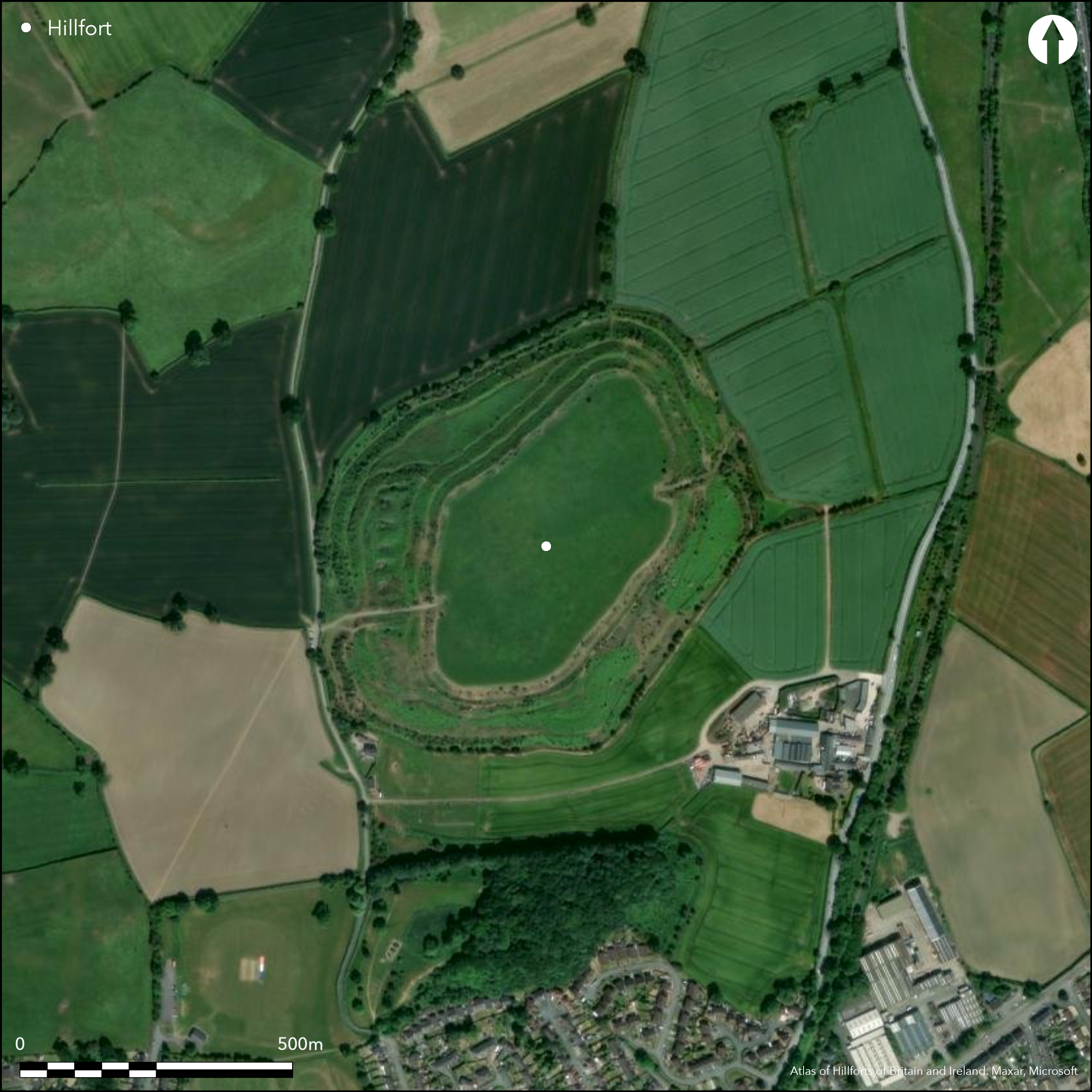
Satellite Imagery
LiDAR 1m DTM Hillshade
Satellite Imagery
Scroll left/right to view further images.
HER: Shropshire 351 (None)
NMR: SJ 23 SE 7 (66112)
SM: 1014899
NGR: SJ295310
X: 329569 Y: 331017 (OSGB36)
One of the finest hillforts in the country and, although not as big, rivalling Maiden Castle in Dorset. Described by Cyril Fox as 'the outstanding work of early iron Age type on the Marches of Wales' and by Michael Watson (2002) as 'big, bold and brassy'. It is located on a glacial knoll overlooking the North Shropshire Plain to the N and E. Internal area c. 5.3ha. The site is enclosed for much of the circuit by five ramparts and ditches, which rise to seven on the W side. The outer bank may be a counterscarp. There are two superb entrances, that on the W dominating the whole site. Its 20m wide entrance rises in an inturned passageway to the interior and flanked by ramparts for its whole length. It is unique in having 11 deep rectangular hollows or pits, divided by banks, on each side of this passage. Their function is unknown and various theories have been put forward, from status, monumentality and display to large quarry hollows, animal corrals and water storage, among others. Whatever it may be, they certainly add to the imposing nature of the structure and in this their true nature may lie. The opposing E entrance, although not as imposing as that on the W, is nevertheless a long heavily defended passageway, with flanking rampart on the S side. Excavations by Varley in 1939-40 showed late Bronze Age origins to the site when protected by a palisade and from c. 600 BC the formidable defences were constructed in phases. This began with a single stone-revetted rampart later added to by successive circuits of defence. Finally, the great W entrance was re-modelled and the massive ramparts of today constructed. The ramparts are in good order, although scrub and bracken poses a challenge to Historic England who have managed the site for many years. The interior, devoted to permanent grazed pasture, has, however, suffered from past target practice and trench construction from the nearby Park Hall army camp during WWI. On 1st Ed OS map (1885-1900).
Citizen Science: ✗
Reliability of Data: Confirmed
Reliability of Interpretation: Confirmed
X: -339285 Y: 6959352 (EPSG: 3857)
Longitude: -3.0478472591118146 Latitude: 52.87197812606737 (EPSG:4326)
Country: England
Current County or Unitary Authority: Shropshire
Historic County: Shropshire
Current Parish/Community/Council/Townland: Selattyn and Gobowen
Good condition but has suffered from scrub and bracken encroachment in the past which poses management problems. Very popular recreation site results in some visitor erosion.
| Extant | ✓ |
| Cropmark | ✗ |
| Likely Destroyed | ✗ |
Interior grazed, as were the banks in the past. SSSI.
| Woodland | ✗ |
| Commercial Forestry Plantation | ✗ |
| Parkland | ✗ |
| Pasture (Grazing) | ✓ |
| Arable | ✗ |
| Scrub/Bracken | ✓ |
| Bare Outcrop | ✗ |
| Heather/Moorland | ✗ |
| Heath | ✗ |
| Built-up | ✗ |
| Coastal Grassland | ✗ |
| Other | ✗ |
Fine contour fort located on a glacial knoll overlooking the North Shropshire Plain to the N and E.
| Contour Fort | ✓ |
| Partial Contour Fort | ✗ |
| Promontory Fort | ✗ |
| Hillslope Fort | ✗ |
| Level Terrain Fort | ✗ |
| Marsh Fort | ✗ |
| Multiple Enclosure Fort | ✗ |
| Hilltop | ✗ |
| Coastal Promontory | ✗ |
| Inland Promontory | ✗ |
| Valley Bottom | ✗ |
| Knoll/Hillock/Outcrop | ✓ |
| Ridge | ✗ |
| Cliff/Plateau-edge/Scarp | ✗ |
| Hillslope | ✗ |
| Lowland | ✗ |
| Spur | ✗ |
Dominant Topographic Feature: Glacial knoll
| North | ✗ |
| Northeast | ✗ |
| East | ✗ |
| Southeast | ✗ |
| South | ✗ |
| Southwest | ✗ |
| West | ✗ |
| Northwest | ✗ |
| Level | ✓ |
Altitude: 165.0m
N/A
Probable late Bronze Age origins, with occupation to the late Iron Age based on excavation finds and morphology of earthworks.
Reliability: C - Low
| Pre 1200BC | ✗ |
| 1200BC - 800BC | ✗ |
| 800BC - 400BC | ✓ |
| 400BC - AD50 | ✓ |
| AD50 - AD400 | ✗ |
| AD400 - AD 800 | ✗ |
| Post AD800 | ✗ |
| Unknown | ✗ |
| Pre Hillfort: | None |
| Post Hillfort: | None |
| Artefactual: | VCP and bronze working finds |
| Morphology/Earthwork/Typology: | Probable late Bronze Age origins, with occupation to the late Iron Age. |
In Aubrey's Monumenta Britannica (1665-1693). On 1st Ed OS map (1885-1900). Excavation by Varley 1939-40, but no excavation report published. Air Photograph Interpretation RCHME: Marches Uplands NMP 1993-2000.Shropshire Council survey 2012.
| Other (1977): | Visit by Hillfort Study Group |
| Other (2012): | Shropshire Council survey 2012. |
| 1st Identified Written Reference (None): | Aubrey's Monumenta Britannica. |
| 1st Identified Map Depiction (None): | 1st Ed OS |
| Excavation (None): | Excavation by Varley 1939-40, but no excavation report published. |
| Other (None): | Air Photograph Interpretation RCHME: Marches Uplands NMP. |
Finds of VCP and evidence of metal working in bronze using copper ore from Llanymeynech Hill. Some evidence of stone-built strutures in the interior.
Stream located 0.1m outside the fort.
| None | ✓ |
| Spring | ✗ |
| Stream | ✗ |
| Pool | ✗ |
| Flush | ✗ |
| Well | ✗ |
| Other | ✗ |
Evidence of WWI trench construction.
| No Known Features | ✗ |
| Round Stone Structures | ✗ |
| Rectangular Stone Structures | ✗ |
| Curvilinear Platforms | ✗ |
| Other Roundhouse Evidence | ✗ |
| Pits | ✗ |
| Quarry Hollows | ✗ |
| Other | ✓ |
Evidence of stone-built structures, but no excavation report by Varley to provide detail.
| No Known Excavation | ✗ |
| Pits | ✗ |
| Postholes | ✗ |
| Roundhouses | ✓ |
| Rectangular Structures | ✓ |
| Roads/Tracks | ✗ |
| Quarry Hollows | ✗ |
| Other | ✗ |
| Nothing Found | ✗ |
None
| No Known Geophysics | ✓ |
| Pits | ✗ |
| Roundhouses | ✗ |
| Rectangular Structures | ✗ |
| Roads/Tracks | ✗ |
| Quarry Hollows | ✗ |
| Other | ✗ |
| Nothing Found | ✗ |
Finds of VCP and evidence of metal working in bronze using copper ore from Llanymeynech Hill, but no excavation report to provide detail and finds lost.
| No Known Finds | ✗ |
| Pottery | ✓ |
| Metal | ✗ |
| Metalworking | ✓ |
| Human Bones | ✗ |
| Animal Bones | ✗ |
| Lithics | ✗ |
| Environmental | ✗ |
| Other | ✓ |
None
| APs Not Checked | ✓ |
| None | ✗ |
| Roundhouses | ✗ |
| Rectangular Structures | ✗ |
| Pits | ✗ |
| Postholes | ✗ |
| Roads/Tracks | ✗ |
| Other | ✗ |
Two - W and E. The W entrance has a long 20m wide inturned corridor flanked by rows of ramparts and eleven pits/depressions on either side. The long E entrance inturned passageway has flanking ramparts on the S side.
| 2: | No modern gaps visible. |
| 2: | Two - W and E. The W entrance has a long 20m wide corridor flanked by rows of ramparts and eleven pits/depressions on either side. The long E entrance passageway has flanking ramparts on the S side. |
Guard Chambers: ✗
Chevaux de Frise: ✗
| 1. Passage-way/Corridor (West): | The W entrance has a long 20m wide inturned corridor flanked by rows of ramparts |
| 1. In-turned (West): | None |
| 1. Other Forms (West): | Flanked by rows of ramparts and eleven pits/depressions on either side adding to monumentality. |
| 2. Passage-way/Corridor (East): | The long E entrance inturned passageway has flanking ramparts on the S side. |
| 2. In-turned (East): | None |
The site is enclosed for much of the circuit by five ramparts and ditches, which rise to seven on the W side. Outer bank may be a counterscarp. Excavations by Varley in 1939-40 showed late Bronze Age origins to the site when protected by a palisade and from c. 600 BC the formidable defences were constructed in phases. This began with a single stone-revetted rampart later added to by successive circuits of defence. Finally, the great W entrance was re-modelled and the massive ramparts of today constructed.
| Area 1: | 5.3ha. |
| Total: | 5.3ha. |
Total Footprint Area: Noneha.
None
| ✓ | Phased construction. |
| ✗ | The ramparts are complete. |
| NE Quadrant: | 5 |
| SE Quadrant: | 5 |
| SW Quadrant: | 7 |
| NW Quadrant: | 7 |
| Total: | 7 |
| Partial Univallate | ✗ |
| Univallate | ✗ |
| Partial Bivallate | ✗ |
| Bivallate | ✗ |
| Partial Multivallate | ✗ |
| Multivallate | ✓ |
| Unknown | ✗ |
| Partial Univallate | ✗ |
| Univallate | ✓ |
| Partial Bivallate | ✗ |
| Bivallate | ✗ |
| Partial Multivallate | ✗ |
| Multivallate | ✗ |
Outer bank may be a counterscarp.
| None | ✗ |
| Earthen Bank | ✓ |
| Stone Wall | ✗ |
| Rubble | ✗ |
| Wall-walk | ✗ |
| Evidence of Timber | ✗ |
| Vitrification | ✗ |
| Other Burning | ✗ |
| Palisade | ✗ |
| Counter Scarp Bank | ✓ |
| Berm | ✗ |
| Unfinished | ✗ |
| Other | ✗ |
Excavations by Varley in 1939-40 showed late Bronze Age origins to the site when protected by a palisade and from c. 600 BC the formidable defences were constructed in phases. This began with a single stone-revetted rampart later added to by successive circuits of defence. Finally, the great W entrance was re-modelled and the massive ramparts of today constructed.
| None | ✗ |
| Earthen Bank | ✓ |
| Stone Wall | ✓ |
| Murus Duplex | ✗ |
| Timber-framed | ✗ |
| Timber-laced | ✗ |
| Vitrification | ✗ |
| Other Burning | ✗ |
| Palisade | ✓ |
| Counter Scarp Bank | ✗ |
| Berm | ✗ |
| Unfinished | ✗ |
| No Known Excavation | ✗ |
| Other | ✗ |
| ✗ | None |
| ✓ | The ditches vary about the circuit. |
Number of Ditches: 5
| ✗ | None |
Dorling, P. and Wigley, A. 2012. Assessment of the archaeological and conservation status of major later prehistoric enclosures in Herefordshire and Shropshire, EH PNUM, Version 3.2, Hereford and Shrewsbury: Herefordshire Council/Shropshire Council.
Hughes, G 1994. Old Oswestry Hillfort. Excavations by W.J. Varley 1939-40, Arch Camb, 143, 46-91;
Smith, N. 2010. Old Oswestry. Selattyn and Gobowen, Shropshire: Analysis of Earthworks: Archaeological Survey. Swindon. English Heritage Research Department Report Series no. 82-2010.
Varley, W.J. 1948. The hillforts of the Welsh Marches, Archaeol J, 105, 41-6.
Watson 2002: Shropshire an archaeological guide, 30-1, aerial photo, Shrewsbury: Shropshire Books; Hannaford 2007; Smith 2010.
Atlas of Hillforts:
Wikidata:
This work is licensed under CC BY-SA 4.0

 and should be cited as:
Lock, Gary and Ralston, Ian. 2024. Atlas of Hillforts of Britain and Ireland. Available at: https://hillforts.arch.ox.ac.uk
Document Version 1.1