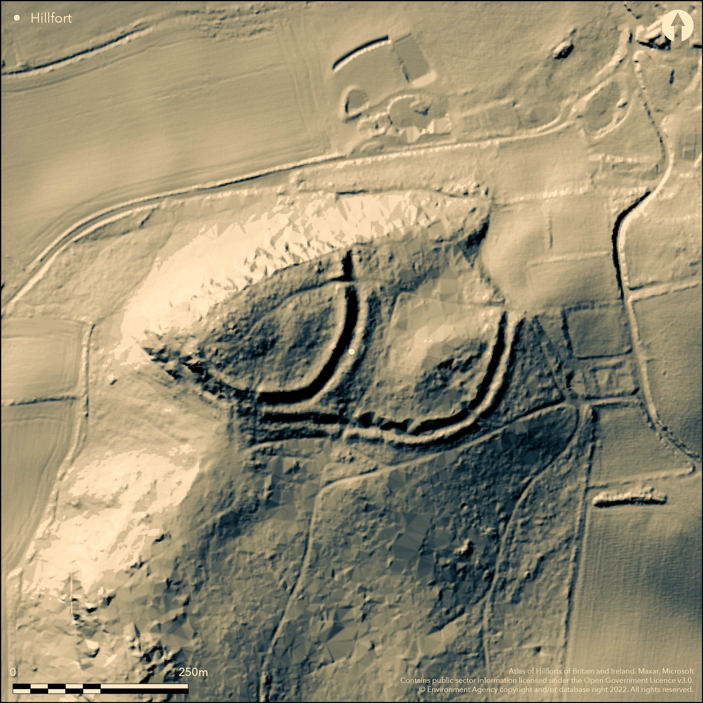
LiDAR 1m DTM Hillshade

Satellite Imagery
LiDAR 1m DTM Hillshade
Satellite Imagery
Scroll left/right to view further images.
HER: Shropshire 1087 (None)
NMR: SJ 31 NE 1 (66453)
SM: 1020285
NGR: SJ 386197
X: 338660 Y: 319796 (OSGB36)
Isolated and now wooded, prominent D-shaped hillfort located in a cliff edge position on Nesscliffe Hill above the River Severn to SW and River Perry to NE. Steep falls to the N, NW and W. Internal area c. 2.8ha. To the S and E are two ramparts with external ditches, the outer now a buried feature. To the NE, where the slopes are steeper, is a single rampart and buried ditch. On the NW the sheer sandstone cliff is adequate defence with no rampart. The S ramparts have been reduced to just two scarps. The ramparts appear to be of dump rubble near the entrance and inner rampart to the south revetted with loose sandstone blocks. The original inturned entrance is at the NE corner at the junction of the univallate to the N and multivallate to the S. The site thus shows several phases of construction dividing the fort into two areas - an area of substantial defences to the W with two ramparts and ditch enclosing the highest point of the site to c. 1ha and an area to the E defined by the existing defences. This latter area has been called an annexe in the past, but this definition may be open to question and a more phased construction is more likely. Small scale excavations by Hume and Jones 1953-56 in SE segment found evidence of Roman occupation layer. Excavations in the S showed that the outer rampart was revetted with loose sandstone blocks. A trench across the inturned entrance found no artefacts. Several coins and 2nd to 4th century pottery (jars and bowls). Earthworks and boundary ditches to the S could be the remains of a field system. Very dense woodland, scrub and bracken. Former coniferous plantation. The site is now a Country Park. On 1st Ed. OS map (1885-1900).
Citizen Science: ✗
Reliability of Data: Confirmed
Reliability of Interpretation: Confirmed
X: -324017 Y: 6940978 (EPSG: 3857)
Longitude: -2.9106910603976375 Latitude: 52.772233163984616 (EPSG:4326)
Country: England
Current County or Unitary Authority: Shropshire
Historic County: Shropshire
Current Parish/Community/Council/Townland: Great Ness
Wooded Country Park owned by Shropshire Council.
| Extant | ✓ |
| Cropmark | ✗ |
| Likely Destroyed | ✗ |
Very dense woodland, scrub and bracken. Former coniferous plantation. Dense undergrowth with understorey of rododendron.
| Woodland | ✓ |
| Commercial Forestry Plantation | ✓ |
| Parkland | ✗ |
| Pasture (Grazing) | ✗ |
| Arable | ✗ |
| Scrub/Bracken | ✓ |
| Bare Outcrop | ✗ |
| Heather/Moorland | ✗ |
| Heath | ✗ |
| Built-up | ✗ |
| Coastal Grassland | ✗ |
| Other | ✗ |
Site covers N summit of the hill on ground rising to the NW and and isolated knoll to the E. Located on the N summit of the prominent Nesscliffe Hill rising above the Shropshire Plain and River Severn to the SW and River Perry to the NE.
| Contour Fort | ✓ |
| Partial Contour Fort | ✗ |
| Promontory Fort | ✗ |
| Hillslope Fort | ✗ |
| Level Terrain Fort | ✗ |
| Marsh Fort | ✗ |
| Multiple Enclosure Fort | ✗ |
| Hilltop | ✓ |
| Coastal Promontory | ✗ |
| Inland Promontory | ✗ |
| Valley Bottom | ✗ |
| Knoll/Hillock/Outcrop | ✗ |
| Ridge | ✗ |
| Cliff/Plateau-edge/Scarp | ✗ |
| Hillslope | ✗ |
| Lowland | ✗ |
| Spur | ✗ |
Dominant Topographic Feature: Summit of hill.
| North | ✗ |
| Northeast | ✗ |
| East | ✗ |
| Southeast | ✗ |
| South | ✗ |
| Southwest | ✗ |
| West | ✗ |
| Northwest | ✗ |
| Level | ✓ |
Altitude: 139.0m
N/A
Roman pottery and coins found of c. 2nd-4th century AD. However, worked flint could indicate earlier occupation or activity.
Reliability: B - Medium
| Pre 1200BC | ✗ |
| 1200BC - 800BC | ✗ |
| 800BC - 400BC | ✗ |
| 400BC - AD50 | ✗ |
| AD50 - AD400 | ✓ |
| AD400 - AD 800 | ✗ |
| Post AD800 | ✗ |
| Unknown | ✗ |
| Pre Hillfort: | None |
| Post Hillfort: | None |
| Artefactual: | Roman pottery and coins found of c. 2nd-4th century AD However, worked flint could indicate earlier occupation or activity. |
On 1st Ed. OS map (1885-1900). Excavation by Hume and Jones 1953-56. Air Photograph Interpretation RCHME: Marches Uplands NMP 1993-2000. Shropshire Council survey 2012.
| Other (2012): | Shropshire Council survey. |
| 1st Identified Map Depiction (None): | OS map. |
| Excavation (None): | Excavation by Hume and Jones. |
| Other (None): | Air Photograph Interpretation RCHME: Marches Uplands NMP. |
Excavation showed no interior features. Several coins and 2nd to 4th century pottery (jars and bowls) found in excavations.
Stream located 0.7km outside the hillfort. The existence of a modern manhole could indicate an earlier water supply on site.
| None | ✗ |
| Spring | ✗ |
| Stream | ✗ |
| Pool | ✗ |
| Flush | ✗ |
| Well | ✓ |
| Other | ✗ |
None
| No Known Features | ✓ |
| Round Stone Structures | ✗ |
| Rectangular Stone Structures | ✗ |
| Curvilinear Platforms | ✗ |
| Other Roundhouse Evidence | ✗ |
| Pits | ✗ |
| Quarry Hollows | ✗ |
| Other | ✗ |
Excavation showed no interior features.
| No Known Excavation | ✗ |
| Pits | ✗ |
| Postholes | ✗ |
| Roundhouses | ✗ |
| Rectangular Structures | ✗ |
| Roads/Tracks | ✗ |
| Quarry Hollows | ✗ |
| Other | ✗ |
| Nothing Found | ✓ |
None
| No Known Geophysics | ✓ |
| Pits | ✗ |
| Roundhouses | ✗ |
| Rectangular Structures | ✗ |
| Roads/Tracks | ✗ |
| Quarry Hollows | ✗ |
| Other | ✗ |
| Nothing Found | ✗ |
Several coins and 2nd to 4th century pottery (jars and bowls) found in excavations. Worked flint.
| No Known Finds | ✗ |
| Pottery | ✓ |
| Metal | ✗ |
| Metalworking | ✗ |
| Human Bones | ✗ |
| Animal Bones | ✗ |
| Lithics | ✓ |
| Environmental | ✗ |
| Other | ✓ |
None
| APs Not Checked | ✓ |
| None | ✗ |
| Roundhouses | ✗ |
| Rectangular Structures | ✗ |
| Pits | ✗ |
| Postholes | ✗ |
| Roads/Tracks | ✗ |
| Other | ✗ |
Original narrow passageway 2.5m wide inturned entrance at the NE corner. Three modern gaps, one a forestry track.
| 4: | One original entrance on the NE with three modern gaps, one a forestry track. |
| 2: | Narrow passageway 2.5m wide inturned entrance at the NE corner. |
Guard Chambers: ✗
Chevaux de Frise: ✗
| 1. In-turned (North east): | Narrow passageway 2.5m wide inturned entrance at the NE corner. |
| 1. Passage-way/Corridor (North east): | Narrow passage. |
To the S and E are two ramparts with external ditches, the outer now a buried feature. To the NE, where the slopes are steeper, is a single rampart and buried ditch. On the NW the sheer sandstone cliff is adequate defence with no rampart. The S ramparts have been reduced to just two scarps. The ramparts appear to be of dump rubble near the entrance and inner rampart to the S revetted with loose sandstone blocks.
| Area 1: | 1.0ha. |
| Area 2: | 2.8ha. |
| Total: | 2.8ha. |
Total Footprint Area: Noneha.
Ramparts univallate to the north where steeper slopes and bivallate to the south. On the NW side are sheer cliffs not requiring rampart defence.
| ✓ | Site shows several phases of construction dividing the fort into two areas - an area of substantial defences to the W with two ramparts and ditch enclosing the highest point of the site to c. 1ha and an area to the E defined by the existing defences. |
| ✗ | NW side sheer cliffs, thus not requiring rampart defence. |
| NE Quadrant: | 1 |
| SE Quadrant: | 2 |
| SW Quadrant: | 2 |
| NW Quadrant: | 0 |
| Total: | 2 |
| Partial Univallate | ✓ |
| Univallate | ✗ |
| Partial Bivallate | ✓ |
| Bivallate | ✗ |
| Partial Multivallate | ✗ |
| Multivallate | ✗ |
| Unknown | ✗ |
| Partial Univallate | ✗ |
| Univallate | ✗ |
| Partial Bivallate | ✗ |
| Bivallate | ✓ |
| Partial Multivallate | ✗ |
| Multivallate | ✗ |
Small exposure on the N side of the entrance showed dump rubble construction.
| None | ✗ |
| Earthen Bank | ✓ |
| Stone Wall | ✗ |
| Rubble | ✓ |
| Wall-walk | ✗ |
| Evidence of Timber | ✗ |
| Vitrification | ✗ |
| Other Burning | ✗ |
| Palisade | ✗ |
| Counter Scarp Bank | ✗ |
| Berm | ✗ |
| Unfinished | ✗ |
| Other | ✗ |
Excavations in the S showed that the outer rampart was revetted with loose sandstone blocks.
| None | ✗ |
| Earthen Bank | ✓ |
| Stone Wall | ✓ |
| Murus Duplex | ✗ |
| Timber-framed | ✗ |
| Timber-laced | ✗ |
| Vitrification | ✗ |
| Other Burning | ✗ |
| Palisade | ✗ |
| Counter Scarp Bank | ✗ |
| Berm | ✗ |
| Unfinished | ✗ |
| No Known Excavation | ✗ |
| Other | ✗ |
| ✗ | None |
| ✓ | The outer ditch is now a buried feature. Vertical faces of the rock-cut ditch can be seen at the entrance. |
Number of Ditches: 2
| ✗ | The E part of the site has been called an annexe in the past, but a phased construction is more likely. |
Dorling, P. and Wigley, A. 2012: Assessment of the archaeological and conservation status of major later prehistoric enclosures in Herefordshire and Shropshire, EH PNUM, Version 3.2, Hereford and Shrewsbury: Herefordshire Council/Shropshire Council.
Hume, C.R. and Jones, G.W. 1959. Excavations at Nesscliffe Hill Trans Shropshire Archaeol Soc, 56, 129-32.
Page, W. ed. 1908. Victoria County History of Shropshire, 1, 355-56, Institute of Historical Research.
Atlas of Hillforts:
Wikidata:
This work is licensed under CC BY-SA 4.0![]()
![]()
![]() and should be cited as:
and should be cited as:
Lock, Gary and Ralston, Ian. 2024. Atlas of Hillforts of Britain and Ireland. Available at: https://hillforts.arch.ox.ac.uk
Document Version 1.1