LiDAR 1m DTM Hillshade
Satellite Imagery
LiDAR 1m DTM Hillshade
Satellite Imagery
Scroll left/right to view further images.
HER: Shropshire 3446 (None)
NMR: SJ 71 NE 17 (73890)
SM: 1020275
NGR: SJ 756164
X: 375639 Y: 316456 (OSGB36)
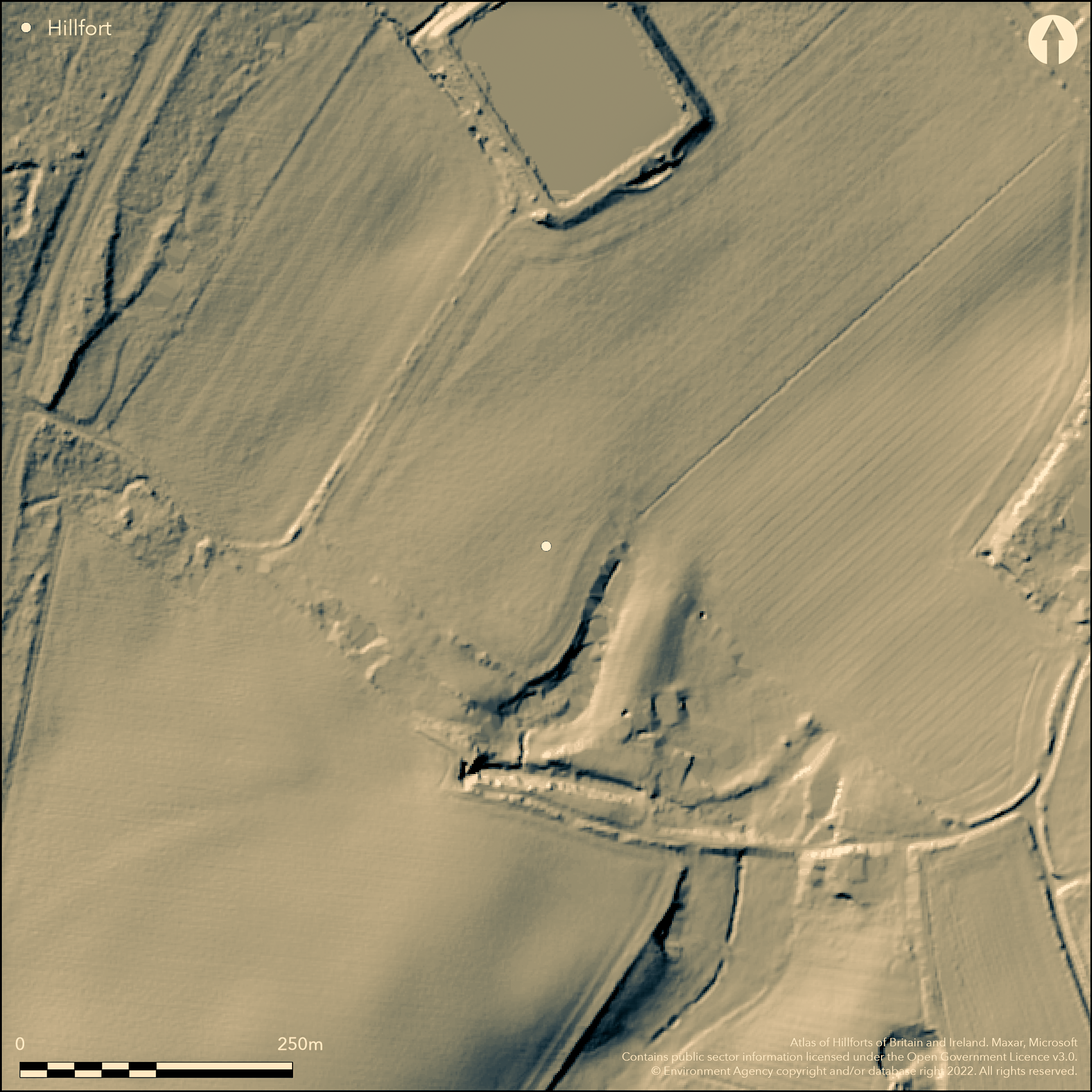
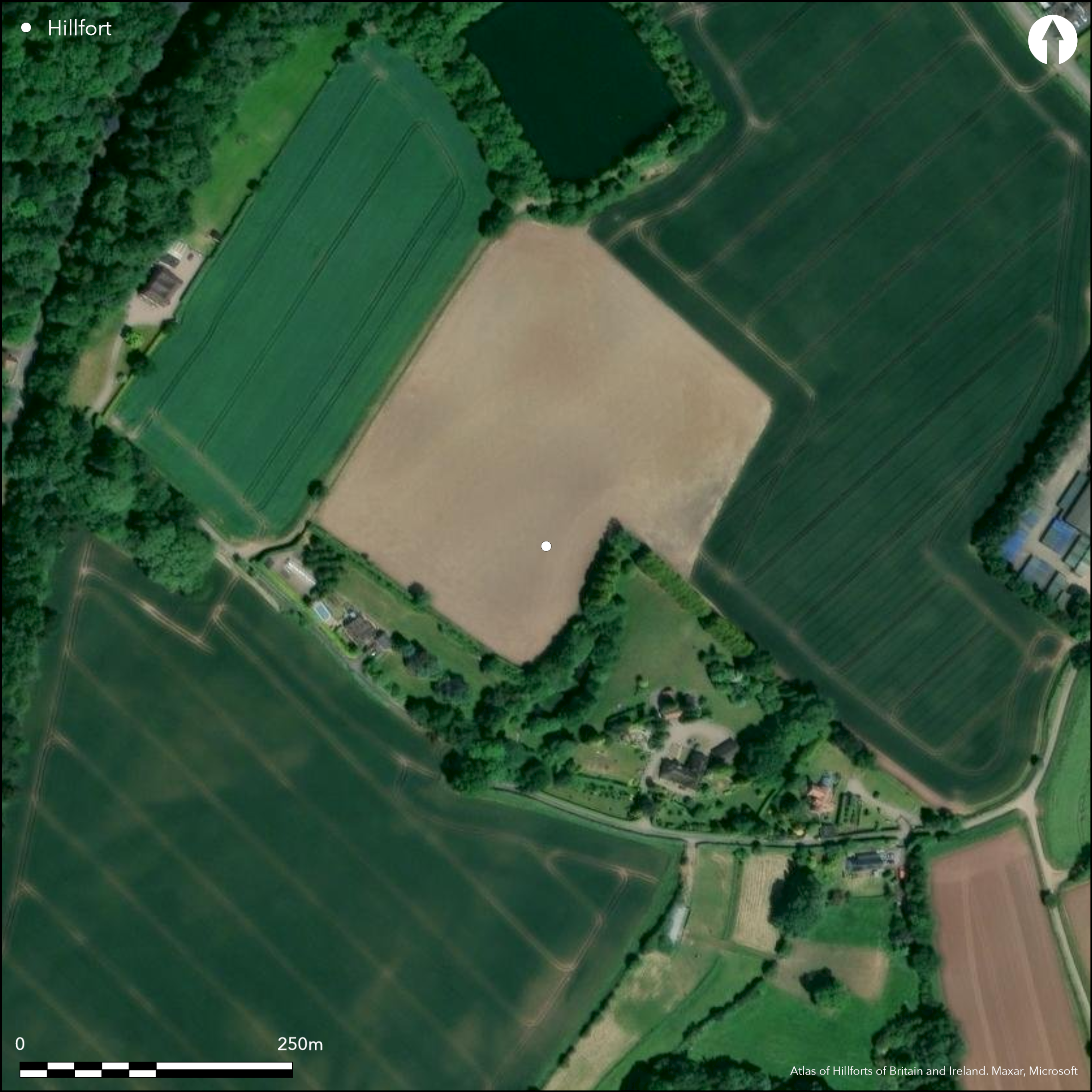
The remains of a small, pear-shaped, trivallate in parts, level terrain hillfort located on undulating ground near Pave Lane village, and incorporating a curvilinear glacial gully into the circuit. Area determined from cropmarks on satellite image. The earthworks have been gradually removed by ploughing over the past 20-30 years and are now only cropmarks, but some earthworks remain to the S. Here the single bank is now reduced to c. 0.2m in height with frontal ditch around 4m in width, now infilled and a buried feature. To the N there are two additional banks, interspaced with two principal ditches, also c. 4m in width and now infilled as buried features. Ploughing has reduced these N banks to mere cropmarks. The natural glacial gully has been incorporated into the defining circuit with a ditch dug along its base. The main entrance is to the SW, with a causeway flanked on either side by ditches which connect with the concentric ditches of the enclosure. Excavations undertaken by G.H. Smith in 1990 found a cobbled surface here of probable Iron Age date. Geophysics also showed another possible entrance to the NE as a buried feature. Limited excavation in the interior showed two curving drip gullies of a possible roundhouse. Partial excavation of the ditches showed it to be c. 2m in depth with a waterlogged base. Pollen analysis proved surrounding area to be of grassland during the Iron Age. Site is mostly down to intensive arable, but earthworks within domestic curtilages remain.
Citizen Science: ✗
Reliability of Data: Confirmed
Reliability of Interpretation: Confirmed
X: -262973 Y: 6935996 (EPSG: 3857)
Longitude: -2.3623240155522813 Latitude: 52.74514921380321 (EPSG:4326)
Country: England; None
Current County or Unitary Authority: Shropshire
Historic County: Shropshire
Current Parish/Community/Council/Townland: Chetwynd Aston; Woodcote
Intensive arable cultivation and ploughing have reduced much of the site to a cropmark. The detritus associated with domestic properties litters part of the site, but site boundaries are generally defined by fences with concrete posts.
| Extant | ✓ |
| Cropmark | ✓ |
| Likely Destroyed | ✗ |
Most of the site is down to intensive arable, but some of the earthwork is within the curtilage of domestic properties.
| Woodland | ✗ |
| Commercial Forestry Plantation | ✗ |
| Parkland | ✗ |
| Pasture (Grazing) | ✗ |
| Arable | ✓ |
| Scrub/Bracken | ✗ |
| Bare Outcrop | ✗ |
| Heather/Moorland | ✗ |
| Heath | ✗ |
| Built-up | ✓ |
| Coastal Grassland | ✗ |
| Other | ✗ |
Generally undulating ground conditions. Located on undulating ground near Pave Lane village and next to a pronounced glacial gully and adjacent bank, also of glacial origin.
| Contour Fort | ✗ |
| Partial Contour Fort | ✗ |
| Promontory Fort | ✗ |
| Hillslope Fort | ✗ |
| Level Terrain Fort | ✓ |
| Marsh Fort | ✗ |
| Multiple Enclosure Fort | ✗ |
| Hilltop | ✗ |
| Coastal Promontory | ✗ |
| Inland Promontory | ✗ |
| Valley Bottom | ✗ |
| Knoll/Hillock/Outcrop | ✗ |
| Ridge | ✗ |
| Cliff/Plateau-edge/Scarp | ✗ |
| Hillslope | ✗ |
| Lowland | ✓ |
| Spur | ✗ |
Dominant Topographic Feature: Undulating ground and glacial features.
| North | ✗ |
| Northeast | ✗ |
| East | ✗ |
| Southeast | ✗ |
| South | ✗ |
| Southwest | ✗ |
| West | ✗ |
| Northwest | ✗ |
| Level | ✓ |
Altitude: 100.0m
Boundary Type: Parish/Townland
Probable Iron Age date.
Reliability: B - Medium
| Pre 1200BC | ✗ |
| 1200BC - 800BC | ✗ |
| 800BC - 400BC | ✓ |
| 400BC - AD50 | ✓ |
| AD50 - AD400 | ✗ |
| AD400 - AD 800 | ✗ |
| Post AD800 | ✗ |
| Unknown | ✗ |
| Pre Hillfort: | None |
| Post Hillfort: | None |
| Other: | Cobbled surface of probable Iron Age date found by excavation of SW entrance. |
Field observation English Heritage 1977, 1984. Excavation and geophysical survey by Smith 1990. Area of the interior, ditches and SW entrance were investigated. Shropshire Council survey 2012.
| Excavation (1990): | By G.H. Smith. |
| Geophysical Survey (1990): | By G.H. Smith. |
| Other (2012): | Shropshire Council survey. |
| Other (None): | Field observation EH. |
Excavations undertaken by G.H. Smith in 1990 found a cobbled surface at the SW entrance of probable Iron Age date. The limited excavation of the interior showed two curving drip gullies of a possible roundhouse. Partial excavation of the ditches showed it to be c. 2m in depth with a waterlogged base. It is possible that this could indicate an on site water supply.
Partial excavation of the ditches showed it to be c. 2m in depth with a waterlogged base. It is possible that this could indicate an on site water supply.
| None | ✗ |
| Spring | ✗ |
| Stream | ✗ |
| Pool | ✗ |
| Flush | ✗ |
| Well | ✗ |
| Other | ✓ |
None
| No Known Features | ✓ |
| Round Stone Structures | ✗ |
| Rectangular Stone Structures | ✗ |
| Curvilinear Platforms | ✗ |
| Other Roundhouse Evidence | ✗ |
| Pits | ✗ |
| Quarry Hollows | ✗ |
| Other | ✗ |
Excavations undertaken by G.H. Smith in 1990 found a cobbled surface at the SW entrance of probable Iron Age date. Into interior? The limited excavation of the interior showed two curving drip gullies of a possible roundhouse.
| No Known Excavation | ✗ |
| Pits | ✗ |
| Postholes | ✗ |
| Roundhouses | ✓ |
| Rectangular Structures | ✗ |
| Roads/Tracks | ✓ |
| Quarry Hollows | ✗ |
| Other | ✓ |
| Nothing Found | ✗ |
Topographical and geophysical surveys determined form and buried features of the site and also showed another possible entrance to the NE as a buried feature.
| No Known Geophysics | ✗ |
| Pits | ✗ |
| Roundhouses | ✗ |
| Rectangular Structures | ✗ |
| Roads/Tracks | ✗ |
| Quarry Hollows | ✗ |
| Other | ✓ |
| Nothing Found | ✗ |
Pollen and waterlogged deposits.
| No Known Finds | ✗ |
| Pottery | ✗ |
| Metal | ✗ |
| Metalworking | ✗ |
| Human Bones | ✗ |
| Animal Bones | ✗ |
| Lithics | ✗ |
| Environmental | ✓ |
| Other | ✓ |
Aerial photographs used to determine site plan.
| APs Not Checked | ✗ |
| None | ✗ |
| Roundhouses | ✗ |
| Rectangular Structures | ✗ |
| Pits | ✗ |
| Postholes | ✗ |
| Roads/Tracks | ✗ |
| Other | ✓ |
The main entrance is visible to the SW, with a causeway flanked on either side by ditches which connect with the concentric ditches of the enclosure. Geophysics also showed another possible entrance to the NE as a buried feature.
| 2: | None |
| 2: | Two original entrances determined, that to the NE by geophysics as a buried feature. |
Guard Chambers: ✗
Chevaux de Frise: ✗
| 1. Simple Gap (South west): | The main entrance is to the SW, with a causeway flanked on either side by ditches which connect with the concentric ditches of the enclosure. |
| 2. Simple Gap (North east): | Possible NE entrance as a buried feature. Simple gap as default. |
The earthworks have been gradually removed by ploughing over the past 20-30 years and are now only cropmarks, but some earthworks remain to the S. Here the single bank is now reduced to c. 0.2m in height with frontal ditch around 4m in width, now infilled and a buried feature. To the N there are two additional banks, interspaced with two principal ditches, also c. 4m in width and now infilled as buried features. Ploughing has reduced these N banks to mere cropmarks. The natural glacial gully has been incorporated into the defensive circuit with a ditch dug along its base.
| Area 1: | 2.1ha. |
| Total: | 2.1ha. |
Total Footprint Area: Noneha.
The three banks of the northern circuit have been reduced to cropmarks by ploughing.
| ✗ | Area determined from satellite imagery. |
| ✓ | Three banks of N circuit reduced to cropmarks. |
| NE Quadrant: | 3 |
| SE Quadrant: | 1 |
| SW Quadrant: | 1 |
| NW Quadrant: | 3 |
| Total: | 3 |
| Partial Univallate | ✓ |
| Univallate | ✗ |
| Partial Bivallate | ✗ |
| Bivallate | ✗ |
| Partial Multivallate | ✓ |
| Multivallate | ✗ |
| Unknown | ✗ |
| Partial Univallate | ✗ |
| Univallate | ✗ |
| Partial Bivallate | ✗ |
| Bivallate | ✗ |
| Partial Multivallate | ✗ |
| Multivallate | ✗ |
None
| None | ✗ |
| Earthen Bank | ✓ |
| Stone Wall | ✗ |
| Rubble | ✗ |
| Wall-walk | ✗ |
| Evidence of Timber | ✗ |
| Vitrification | ✗ |
| Other Burning | ✗ |
| Palisade | ✗ |
| Counter Scarp Bank | ✗ |
| Berm | ✗ |
| Unfinished | ✗ |
| Other | ✗ |
Ditches investigated, showed to be c. 2m in depth with waterlogged base.
| None | ✗ |
| Earthen Bank | ✗ |
| Stone Wall | ✗ |
| Murus Duplex | ✗ |
| Timber-framed | ✗ |
| Timber-laced | ✗ |
| Vitrification | ✗ |
| Other Burning | ✗ |
| Palisade | ✗ |
| Counter Scarp Bank | ✗ |
| Berm | ✗ |
| Unfinished | ✗ |
| No Known Excavation | ✗ |
| Other | ✓ |
| ✗ | None |
| ✓ | Ditches investigated, showed to be c. 2m in depth with waterlogged base. It is possible that there might be a third ditch as a buried feature to be determined. |
Number of Ditches: 2
| ✗ | None |
Dorling, P. and Wigley, A. 2012. Assessment of the archaeological and conservation status of major later prehistoric enclosures in Herefordshire and Shropshire, EH PNUM, Version 3.2, Hereford and Shrewsbury: Herefordshire Council/Shropshire Council.
Smith, G.H. 1990: Chetwyn Aston. SAM SA352 CEU Site 455, Archaeological Assessment. Excavation Report.
Atlas of Hillforts:
Wikidata:
This work is licensed under CC BY-SA 4.0![]()
![]()
![]() and should be cited as:
and should be cited as:
Lock, Gary and Ralston, Ian. 2024. Atlas of Hillforts of Britain and Ireland. Available at: https://hillforts.arch.ox.ac.uk
Document Version 1.1