LiDAR 1m DTM Hillshade
Satellite Imagery
LiDAR 1m DTM Hillshade
Satellite Imagery
Scroll left/right to view further images.
HER: Shropshire 456 (None)
NMR: SO 39 SE 1 (107489)
SM: 1021072
NGR: SO 398932
X: 339798 Y: 293222 (OSGB36)
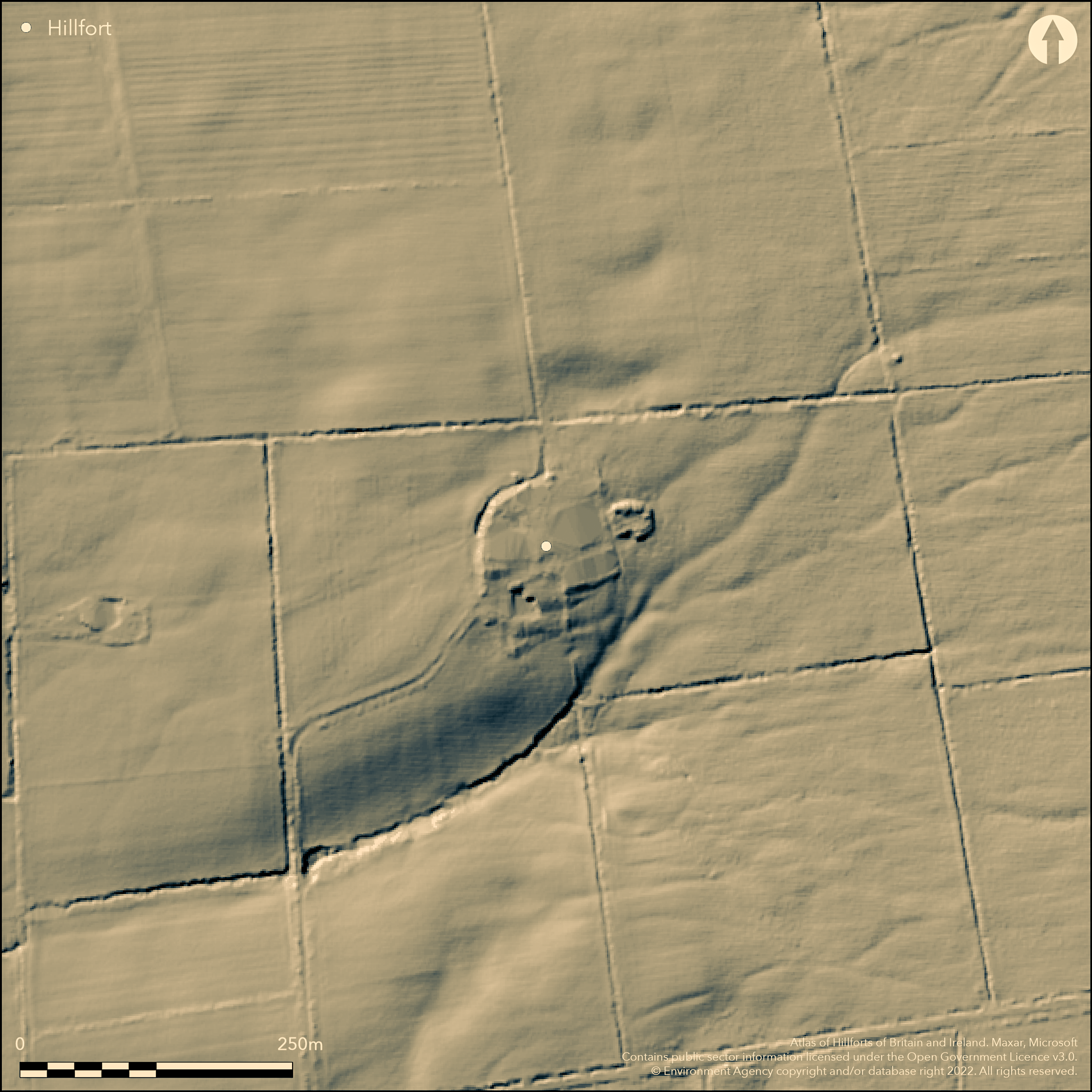
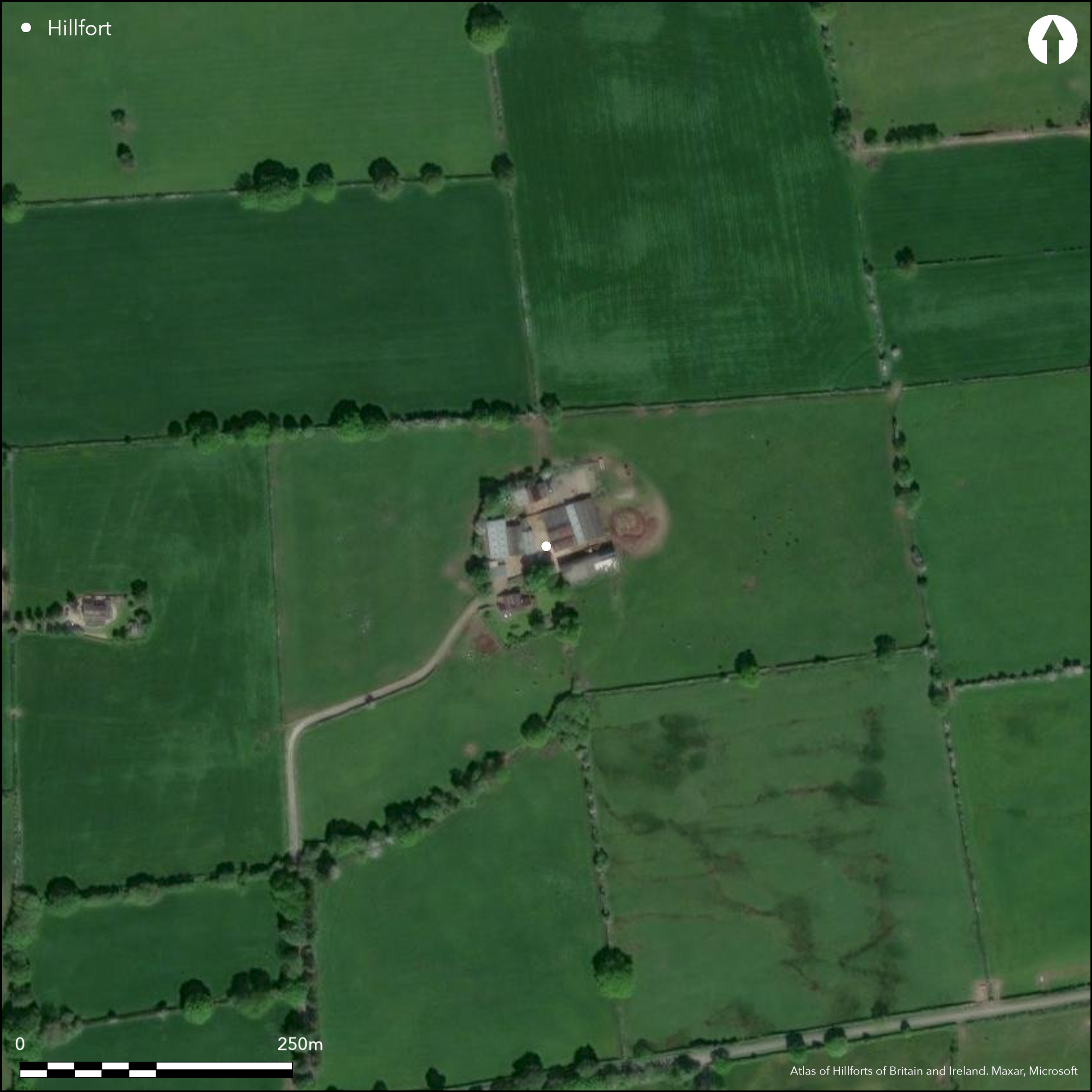
Mutilated hillslope fort on Wentnor Prolley Moor overlooking Criftin Brook and above the River East Onny on the edge of a plateau at the foot of the Long Mynd. Site has been very badly affected by development as a farmhouse and ancillary farm buildings and yards are located within the enclosure. Banks have been much reduced by ploughing and destroyed on the SW where the house is located. Basically the fort was an oval, double-banked and ditched enclosure, some 55m in diameter internally and 110m externally, with internal area c. 0.23ha. On the E side the outer ditch remains virtually intact, but trampled by cattle, 8m-9m wide, but only 0.3m deep at most. The inner ditch on the E is now only a slight scarp, whilst that on the W little remains. On the NW the outer ditch is now the course of a stream and hedge bank, which may be the site of the rampart. Only fragments of the bank remains in places. Small excavation by Hughes and Jones 1990 in advance of farmhouse extension found clay deposits possibly being part of the inner bank, a small curvilinear feature and a posthole, also earlier pottery sherds and a Bronze Age cremation urn with flint flakes. It is possible that the entrance was downslope, possibly indicating a farming or transhumance site. On 1st Ed OS map (1885-1900).
Citizen Science: ✗
Reliability of Data: Confirmed
Reliability of Interpretation: Confirmed
X: -321598 Y: 6897169 (EPSG: 3857)
Longitude: -2.888966458688047 Latitude: 52.53349330425439 (EPSG:4326)
Country: England
Current County or Unitary Authority: Shropshire
Historic County: Shropshire
Current Parish/Community/Council/Townland: Wentnor
Paert-destroyed and very badly affected by development as a farmhouse and ancillary farm buildings and yards are located within the enclosure. Banks ploughed-down and dispersed.
| Extant | ✓ |
| Cropmark | ✗ |
| Likely Destroyed | ✓ |
Farm located in the interior and site cultivated.
| Woodland | ✗ |
| Commercial Forestry Plantation | ✗ |
| Parkland | ✗ |
| Pasture (Grazing) | ✗ |
| Arable | ✓ |
| Scrub/Bracken | ✗ |
| Bare Outcrop | ✗ |
| Heather/Moorland | ✗ |
| Heath | ✗ |
| Built-up | ✓ |
| Coastal Grassland | ✗ |
| Other | ✗ |
Hillslope fort on Wentnor Prolley Moor overlooking Criftin Brook and above the River East Onny on the edge of a plateau at the foot of the Long Mynd. Slopes gently to the S and SW.
| Contour Fort | ✗ |
| Partial Contour Fort | ✗ |
| Promontory Fort | ✗ |
| Hillslope Fort | ✓ |
| Level Terrain Fort | ✗ |
| Marsh Fort | ✗ |
| Multiple Enclosure Fort | ✗ |
| Hilltop | ✗ |
| Coastal Promontory | ✗ |
| Inland Promontory | ✗ |
| Valley Bottom | ✗ |
| Knoll/Hillock/Outcrop | ✗ |
| Ridge | ✗ |
| Cliff/Plateau-edge/Scarp | ✓ |
| Hillslope | ✓ |
| Lowland | ✗ |
| Spur | ✗ |
Dominant Topographic Feature: Plateau edge.
| North | ✗ |
| Northeast | ✗ |
| East | ✗ |
| Southeast | ✗ |
| South | ✓ |
| Southwest | ✓ |
| West | ✗ |
| Northwest | ✗ |
| Level | ✗ |
Altitude: 265.0m
N/A
Probably Iron Age, but earlier pottery sherds and a Bronze Age cremation urn with flint flakes indicating a possible early origin to the site or early activity.
Reliability: B - Medium
| Pre 1200BC | ✗ |
| 1200BC - 800BC | ✗ |
| 800BC - 400BC | ✓ |
| 400BC - AD50 | ✓ |
| AD50 - AD400 | ✗ |
| AD400 - AD 800 | ✗ |
| Post AD800 | ✗ |
| Unknown | ✗ |
| Pre Hillfort: | None |
| Post Hillfort: | None |
| Artefactual: | Of significance were earlier pottery sherds and a Bronze Age cremation urn with flint flakes indicating a possible early origin to the site or early activity. |
On 1st Ed OS map (1885-1900). Small excavation Hughes and Jones 1990. Air Photograph Interpretation RCHME: Marches Uplands NMP 1993-2000.
| Excavation (1990): | Hughes and Jones. |
| 1st Identified Map Depiction (None): | 1st Ed OS |
In 1990 a small excavation in advance of farmhouse extension found clay deposits possibly being part of the inner bank, a small curvilinear feature and a post hole. Pottery sherds and a Bronze Age cremation urn with flint flakes were found.
Stream located 0.28 outside the fort.
| None | ✓ |
| Spring | ✗ |
| Stream | ✗ |
| Pool | ✗ |
| Flush | ✗ |
| Well | ✗ |
| Other | ✗ |
None
| No Known Features | ✓ |
| Round Stone Structures | ✗ |
| Rectangular Stone Structures | ✗ |
| Curvilinear Platforms | ✗ |
| Other Roundhouse Evidence | ✗ |
| Pits | ✗ |
| Quarry Hollows | ✗ |
| Other | ✗ |
In 1990 a small excavation in advance of farmhouse extension found clay deposits possibly being part of the inner bank, a small curvilinear feature and a posthole.
| No Known Excavation | ✗ |
| Pits | ✗ |
| Postholes | ✓ |
| Roundhouses | ✗ |
| Rectangular Structures | ✗ |
| Roads/Tracks | ✗ |
| Quarry Hollows | ✗ |
| Other | ✓ |
| Nothing Found | ✗ |
None
| No Known Geophysics | ✓ |
| Pits | ✗ |
| Roundhouses | ✗ |
| Rectangular Structures | ✗ |
| Roads/Tracks | ✗ |
| Quarry Hollows | ✗ |
| Other | ✗ |
| Nothing Found | ✗ |
Pottery sherds and a Bronze Age cremation urn with flint flakes were found.
| No Known Finds | ✗ |
| Pottery | ✓ |
| Metal | ✗ |
| Metalworking | ✗ |
| Human Bones | ✗ |
| Animal Bones | ✗ |
| Lithics | ✓ |
| Environmental | ✗ |
| Other | ✗ |
None
| APs Not Checked | ✓ |
| None | ✗ |
| Roundhouses | ✗ |
| Rectangular Structures | ✗ |
| Pits | ✗ |
| Postholes | ✗ |
| Roads/Tracks | ✗ |
| Other | ✗ |
The site of an entrance has not been determined and probably has been destroyed. Possibly downslope.
| 0: | None |
| 2: | None |
Guard Chambers: ✗
Chevaux de Frise: ✗
The banks have been much reduced by ploughing and destroyed on the SW where the house is located. Basically it was a double-banked and ditched enclosure, some 55m in diameter internally and 110m externally. On the E side the outer ditch remains virtually intact, but trampled by cattle, 8m-9m wide, but only 0.3m deep at most. The inner ditch on the E is now only a slight scarp, whilst that on the W little remains. On the NW the outer ditch is now the course of a stream and hedge bank, which may be the site of the rampart. Only fragments of the bank remains in places.
| Area 1: | 0.23ha. |
| Total: | 0.23ha. |
Total Footprint Area: Noneha.
None
| ✗ | None |
| ✗ | Ramparts almost destroyed. Formerly two surrounded the enclosure. |
| NE Quadrant: | 2 |
| SE Quadrant: | 2 |
| SW Quadrant: | 2 |
| NW Quadrant: | 2 |
| Total: | 2 |
| Partial Univallate | ✗ |
| Univallate | ✗ |
| Partial Bivallate | ✗ |
| Bivallate | ✓ |
| Partial Multivallate | ✗ |
| Multivallate | ✗ |
| Unknown | ✗ |
| Partial Univallate | ✗ |
| Univallate | ✗ |
| Partial Bivallate | ✗ |
| Bivallate | ✗ |
| Partial Multivallate | ✗ |
| Multivallate | ✗ |
None
| None | ✗ |
| Earthen Bank | ✓ |
| Stone Wall | ✗ |
| Rubble | ✗ |
| Wall-walk | ✗ |
| Evidence of Timber | ✗ |
| Vitrification | ✗ |
| Other Burning | ✗ |
| Palisade | ✗ |
| Counter Scarp Bank | ✗ |
| Berm | ✗ |
| Unfinished | ✗ |
| Other | ✗ |
In 1990 a small excavation in advance of farmhouse extension found clay deposits possibly being part of the inner bank.
| None | ✗ |
| Earthen Bank | ✓ |
| Stone Wall | ✗ |
| Murus Duplex | ✗ |
| Timber-framed | ✗ |
| Timber-laced | ✗ |
| Vitrification | ✗ |
| Other Burning | ✗ |
| Palisade | ✗ |
| Counter Scarp Bank | ✗ |
| Berm | ✗ |
| Unfinished | ✗ |
| No Known Excavation | ✗ |
| Other | ✗ |
| ✗ | None |
| ✓ | On the E side the outer ditch remains virtually intact, but trampled by cattle, 8m-9m wide but only 0.3m deep at most. The inner ditch on the E is now only a slight scarp, whilst that on the W little remains. On the NW the outer ditch is now the course of a stream and hedge bank, which may be the site of the rampart. |
Number of Ditches: 2
| ✗ | None |
Hughes, E.G. and Jones, L. 1990. Archaeological field survey and excavation Robury Ring, Shropshire, Birmingham University Field Archaeology Unit Archaeological Evaluation Report, Birmingham: Birmingham University.
Atlas of Hillforts:
Wikidata:
This work is licensed under CC BY-SA 4.0![]()
![]()
![]() and should be cited as:
and should be cited as:
Lock, Gary and Ralston, Ian. 2024. Atlas of Hillforts of Britain and Ireland. Available at: https://hillforts.arch.ox.ac.uk
Document Version 1.1