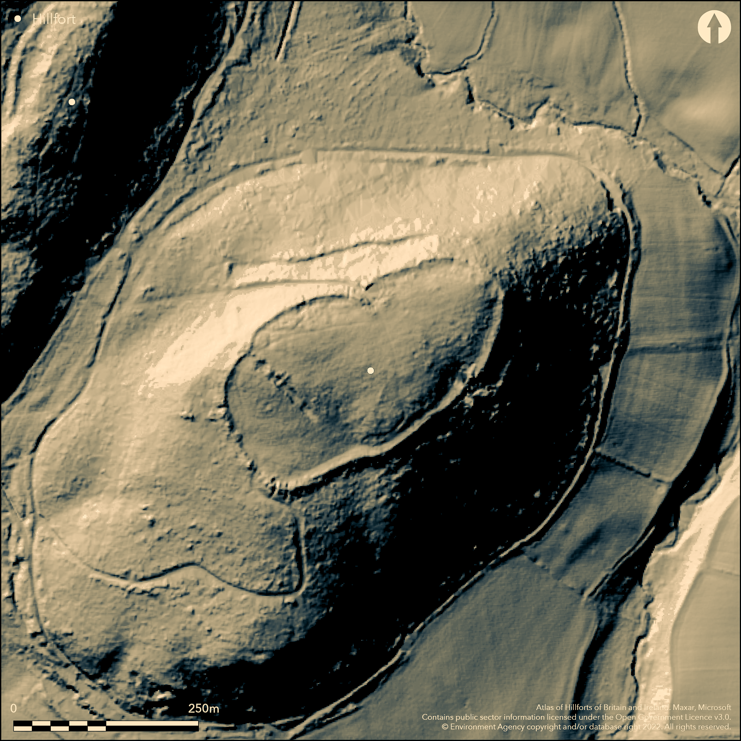
LiDAR 1m DTM Hillshade
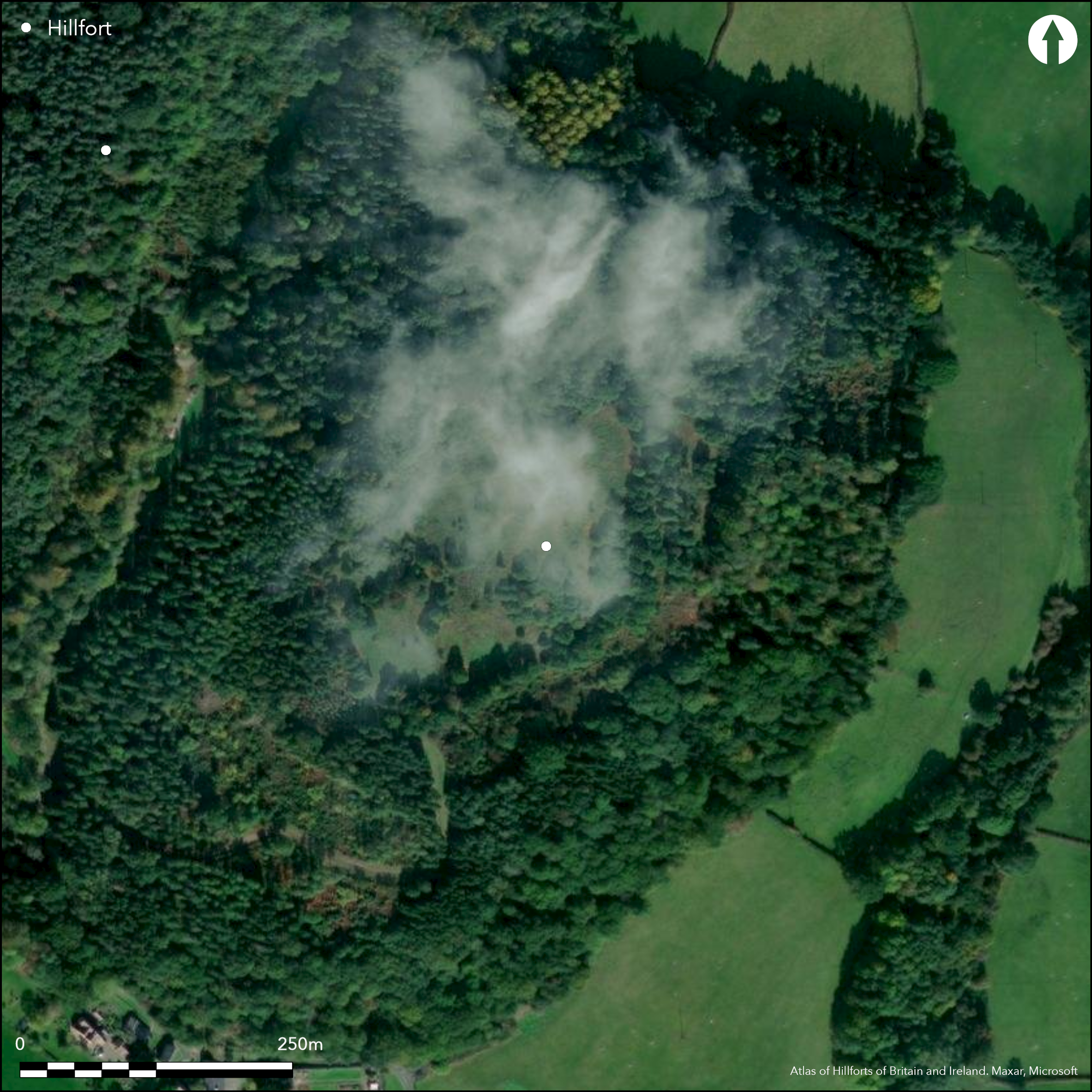
Satellite Imagery
LiDAR 1m DTM Hillshade
Satellite Imagery
Scroll left/right to view further images.
HER: Shropshire 1221 (None)
NMR: SO 39 SW4 (107542)
SM: 1011023
NGR: SO 325924
X: 332538 Y: 292487 (OSGB36)
Fine, contour hillfort located on the higher of the two summits of the wooded Roveries, strategically sited above the headwaters of the Rivers Camlad and Onny and the Lydham Pass, to the SW of the Long Mynd. Fort makes full use of the topography with a single substantial dry-stone revetted rampart surviving on the SW and part of the NW and SE sides. This averages 3.8m in height on the outside, with ditch 5m wide by 0.2m deep, enclosing 2.16ha. Around the NE corner the perimeter is now defined by the top of precipitous natural slopes. The construction of the rampart is clearly seen in trenches left open by excavations undertaken in 1935-39 and 1960-63 (no report for either excavation). There are three possible original entrances, on the NW, SE and N sides, the former two the subject of the two excavations, with trenches also left open and exposing their construction. The deeply-inturned NW entrance, 24m long and 3m wide, is particularly fine, of three phases and with guard chambers at the inner end and at least 20m of thin-slab dry-stone walling preserved. Leading and curving up into this entrance is a possible original causeway, 100m long and now 5m wide, which forms the present vehicle entrance to the fort. To the E of the entrance a berm or terrace has been cut into the hillside 20m below the top of the rampart and extending around the N quarter and possibly constructed to strengthen the entrance. The SE inturned entrance also has exposed stone walling, though complex and much mutilated. A third possible entrance, with a 5m break in the rampart, is located to the N. The excavations of 1960-63 found evidence of an earlier phase and unfinished causewayed ditch partly under the rampart. In the centre of the interior a Neolithic hearth and sherd, with a perforated hammer stone under the S rampart. The pottery was confirmed as Windmill Hill ware. A chance find of a Mesolithic macehead is recorded. The site is generally in good condition, and mostly under grassland in the interior with trees on banks and wooded slopes, although the open trenches remain. On 1st Ed OS map (1885-1900).
Citizen Science: ✗
Reliability of Data: Confirmed
Reliability of Interpretation: Confirmed
X: -333494 Y: 6895804 (EPSG: 3857)
Longitude: -2.995830500332767 Latitude: 52.52603451692648 (EPSG:4326)
Country: England; None
Current County or Unitary Authority: Shropshire
Historic County: Shropshire
Current Parish/Community/Council/Townland: Lydham; More
Excavation trenches of 1930's and 1960's still open and causing problems.
| Extant | ✓ |
| Cropmark | ✗ |
| Likely Destroyed | ✗ |
Interior under pasture with ramparts generally under deciduous trees and scrub, especially at NE end with conifers. Open trenches.
| Woodland | ✓ |
| Commercial Forestry Plantation | ✗ |
| Parkland | ✗ |
| Pasture (Grazing) | ✓ |
| Arable | ✗ |
| Scrub/Bracken | ✓ |
| Bare Outcrop | ✗ |
| Heather/Moorland | ✗ |
| Heath | ✗ |
| Built-up | ✗ |
| Coastal Grassland | ✗ |
| Other | ✓ |
Site makes full use of the natural topography. Located on the higher of the two summits of the wooded Roveries, strategically sited above the headwaters of the Rivers Camlad and Onny and the Lydham Pass, to the SW of the Long Mynd.
| Contour Fort | ✓ |
| Partial Contour Fort | ✗ |
| Promontory Fort | ✗ |
| Hillslope Fort | ✗ |
| Level Terrain Fort | ✗ |
| Marsh Fort | ✗ |
| Multiple Enclosure Fort | ✗ |
| Hilltop | ✓ |
| Coastal Promontory | ✗ |
| Inland Promontory | ✗ |
| Valley Bottom | ✗ |
| Knoll/Hillock/Outcrop | ✗ |
| Ridge | ✗ |
| Cliff/Plateau-edge/Scarp | ✗ |
| Hillslope | ✗ |
| Lowland | ✗ |
| Spur | ✗ |
Dominant Topographic Feature: Roveries Hill.
| North | ✗ |
| Northeast | ✗ |
| East | ✗ |
| Southeast | ✗ |
| South | ✗ |
| Southwest | ✗ |
| West | ✗ |
| Northwest | ✗ |
| Level | ✓ |
Altitude: 259.0m
Boundary Type: Parish/Townland
It is possible that the site had Neolithic origins.
Reliability: D - None
| Pre 1200BC | ✗ |
| 1200BC - 800BC | ✗ |
| 800BC - 400BC | ✗ |
| 400BC - AD50 | ✗ |
| AD50 - AD400 | ✗ |
| AD400 - AD 800 | ✗ |
| Post AD800 | ✗ |
| Unknown | ✓ |
| Pre Hillfort: | Possible. Evidence of Mesolithic macehead and Neolithic hearth and Windmill Hill ware. The excavations of 1960-63 found evidence of an earlier phase and unfinished causewayed ditch partly under the rampart. |
| Post Hillfort: | None |
| Artefactual: | Evidence of Mesolithic macehead and Neolithic hearth and Windmill Hill ware. |
In Aubrey's Monumenta Britannica (1665-1693). On 1st Ed OS map (1885-1900). Small excavations at the NW and SE entrances by Sykes 1935-39 (no report). Excavations at NW and SE entrances and interior by Thomas 1960-61 (no report). Air Photograph Interpretation RCHME: Marches Uplands NMP 1993-2000. Shropshire Council survey 2012. Investigations Shropshire Council 2013-ongoing
| Other (2012): | Shropshire Council survey. |
| 1st Identified Written Reference (None): | Aubrey's Monumenta Britannica. |
| 1st Identified Map Depiction (None): | 1st Ed OS |
| Excavation (None): | Excavations at NW and SE entrances by Sykes. |
| Excavation (None): | Excavations at NW and SE entrances and interior by Thomas. |
| Other (None): | Air Photograph Interpretation RCHME: Marches Uplands NMP. |
| Other (None): | Shropshire Council. |
In the centre of the interior a Neolithic hearth and sherd was found, with a perforated hammer stone under the S rampart. The pottery was confirmed as Windmill Hill ware.
Stream located 0.2km outside the fort.
| None | ✓ |
| Spring | ✗ |
| Stream | ✗ |
| Pool | ✗ |
| Flush | ✗ |
| Well | ✗ |
| Other | ✗ |
None
| No Known Features | ✓ |
| Round Stone Structures | ✗ |
| Rectangular Stone Structures | ✗ |
| Curvilinear Platforms | ✗ |
| Other Roundhouse Evidence | ✗ |
| Pits | ✗ |
| Quarry Hollows | ✗ |
| Other | ✗ |
Neolithic hearth found in the centre of the site.
| No Known Excavation | ✗ |
| Pits | ✗ |
| Postholes | ✗ |
| Roundhouses | ✗ |
| Rectangular Structures | ✗ |
| Roads/Tracks | ✗ |
| Quarry Hollows | ✗ |
| Other | ✓ |
| Nothing Found | ✗ |
None
| No Known Geophysics | ✓ |
| Pits | ✗ |
| Roundhouses | ✗ |
| Rectangular Structures | ✗ |
| Roads/Tracks | ✗ |
| Quarry Hollows | ✗ |
| Other | ✗ |
| Nothing Found | ✗ |
In the centre of the interior a Neolithic hearth and sherd was found, with a perforated hammer stone under the S rampart. The pottery was confirmed as Windmill Hill ware. Chance find of a Mesolithic macehead and half a quartzite pebble.
| No Known Finds | ✗ |
| Pottery | ✓ |
| Metal | ✗ |
| Metalworking | ✗ |
| Human Bones | ✗ |
| Animal Bones | ✗ |
| Lithics | ✓ |
| Environmental | ✗ |
| Other | ✓ |
None
| APs Not Checked | ✓ |
| None | ✗ |
| Roundhouses | ✗ |
| Rectangular Structures | ✗ |
| Pits | ✗ |
| Postholes | ✗ |
| Roads/Tracks | ✗ |
| Other | ✗ |
Entrances to NW, SE and N, former two excavated; trenches left open exposing construction. Fine, deeply inturned NW passageway entrance 24m long and 3m wide, of three phases, with guard chambers at inner end and c. 20m of thin-slab dry-stone walling preserved. Possible original causeway 100m long and now 5m wide. To E of entrance berm or terrace cut into hillside 20m below top of rampart extending around the N quarter. Inturned entrance to SE mutilated. Possible 5m wide gap entrance to N.
| 3: | No modern gaps in evidence. |
| 2: | Three possible original entrances. |
Guard Chambers: ✓
Chevaux de Frise: ✗
| 1. In-turned (North west): | Deeply inturned NW entrance 24m long and 3m wide. |
| 1. Recesses/Guard Chambers (North west): | Guard chambers at inner end. |
| 1. Passage-way/Corridor (North west): | Long passageway. |
| 2. In-turned (South east): | Mutilated inturned entrance. |
| 3. Simple Gap (North): | Possible entrance at 5m gap. |
The fort makes full use of the topography with a single substantial dry-stone revetted rampart surviving on the SW and part of the NW and SE sides. This averages 3.8m in height on the outside, with ditch 5m wide by 0.2m deep. Around the NE corner the perimeter is now defined by the top of precipitous natural slopes. The construction of the rampart is clearly seen in trenches left open from excavations undertaken in 1935-39 and 1960-63.
| Area 1: | 2.16ha. |
| Total: | 2.16ha. |
Total Footprint Area: Noneha.
A single substantial drystone revetted rampart survives on the SW and part of the NW and SE sides. This averages 3.8 m in height on the outside, with ditch 5 m wide x 0.2 m deep. Around the NE corner the perimeter is now defined by the top of precipitous natural slopes.
| ✓ | Phased construction to NW entrance and possibly to hillfort. The excavations of 1960-63 found evidence of an earlier phase and unfinished causewayed ditch partly under the rampart. |
| ✗ | Around the NE corner the perimeter is now defined by the top of precipitous natural slopes. |
| NE Quadrant: | 0 |
| SE Quadrant: | 1 |
| SW Quadrant: | 1 |
| NW Quadrant: | 1 |
| Total: | 1 |
| Partial Univallate | ✓ |
| Univallate | ✗ |
| Partial Bivallate | ✗ |
| Bivallate | ✗ |
| Partial Multivallate | ✗ |
| Multivallate | ✗ |
| Unknown | ✗ |
| Partial Univallate | ✗ |
| Univallate | ✗ |
| Partial Bivallate | ✗ |
| Bivallate | ✗ |
| Partial Multivallate | ✗ |
| Multivallate | ✗ |
The dry-stone revetted construction of the rampart is clearly seen in trenches left open from excavations undertaken in 1935-39 and 1960-63. To E of the entrance a berm or terrace has been cut into the hillside 20m below the top of the rampart and extending around the N quarter and possibly constructed to strengthen the entrance.
| None | ✗ |
| Earthen Bank | ✗ |
| Stone Wall | ✓ |
| Rubble | ✗ |
| Wall-walk | ✗ |
| Evidence of Timber | ✗ |
| Vitrification | ✗ |
| Other Burning | ✗ |
| Palisade | ✗ |
| Counter Scarp Bank | ✗ |
| Berm | ✓ |
| Unfinished | ✗ |
| Other | ✗ |
The dry-stone revetted construction of the rampart is clearly seen in trenches left open from excavations undertaken in 1935-39 and 1960-63. To E of the entrance a berm or terrace has been cut into the hillside 20m below the top of the rampart and extending around the N quarter and possibly constructed to strengthen the entrance. The excavations of 1960-63 found evidence of an earlier phase and unfinished causewayed ditch partly under the rampart.
| None | ✗ |
| Earthen Bank | ✗ |
| Stone Wall | ✓ |
| Murus Duplex | ✗ |
| Timber-framed | ✗ |
| Timber-laced | ✗ |
| Vitrification | ✗ |
| Other Burning | ✗ |
| Palisade | ✗ |
| Counter Scarp Bank | ✗ |
| Berm | ✓ |
| Unfinished | ✓ |
| No Known Excavation | ✗ |
| Other | ✗ |
| ✗ | None |
| ✓ | The ditch is 5m wide by 0.2m deep. The excavations of 1960-63 found evidence of an earlier phase and unfinished causewayed ditch partly under the rampart. |
Number of Ditches: 1
| ✗ | None |
Dorling, P. and Wigley, A. 2012: Assessment of the archaeological and conservation status of major later prehistoric enclosures in Herefordshire and Shropshire, EH PNUM, Version 3.2, Hereford and Shrewsbury: Herefordshire Council/Shropshire Council.
Page, W. ed. 1908. Victoria County History of Shropshire, 1, 366, Institute of Historical Research.
Atlas of Hillforts:
Wikidata:
This work is licensed under CC BY-SA 4.0

 and should be cited as:
Lock, Gary and Ralston, Ian. 2024. Atlas of Hillforts of Britain and Ireland. Available at: https://hillforts.arch.ox.ac.uk
Document Version 1.1