LiDAR 1m DTM Hillshade
Satellite Imagery
LiDAR 1m DTM Hillshade
Satellite Imagery
Scroll left/right to view further images.
HER: West Berkshire MWB1527 (None)
NMR: SU 57 SW 6 (237396)
SM: 1006983
NGR: SU 51094 72216
X: 451094 Y: 172216 (OSGB36)
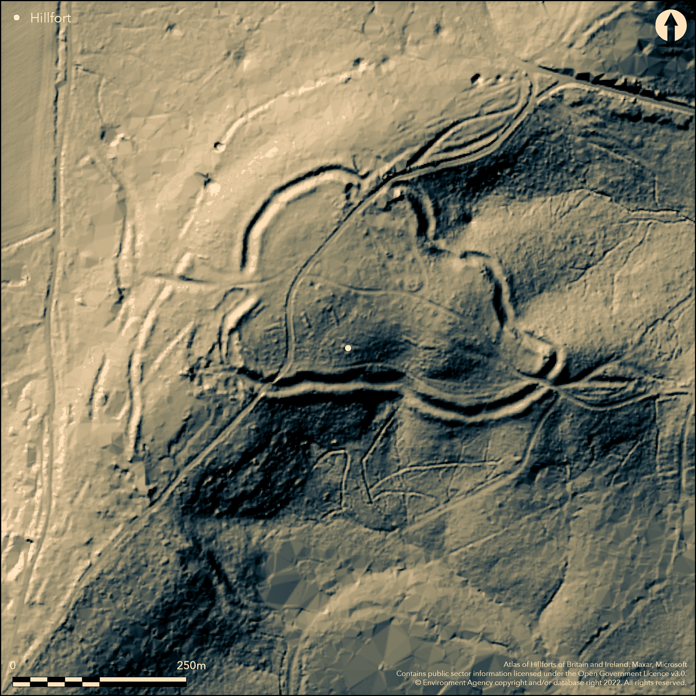
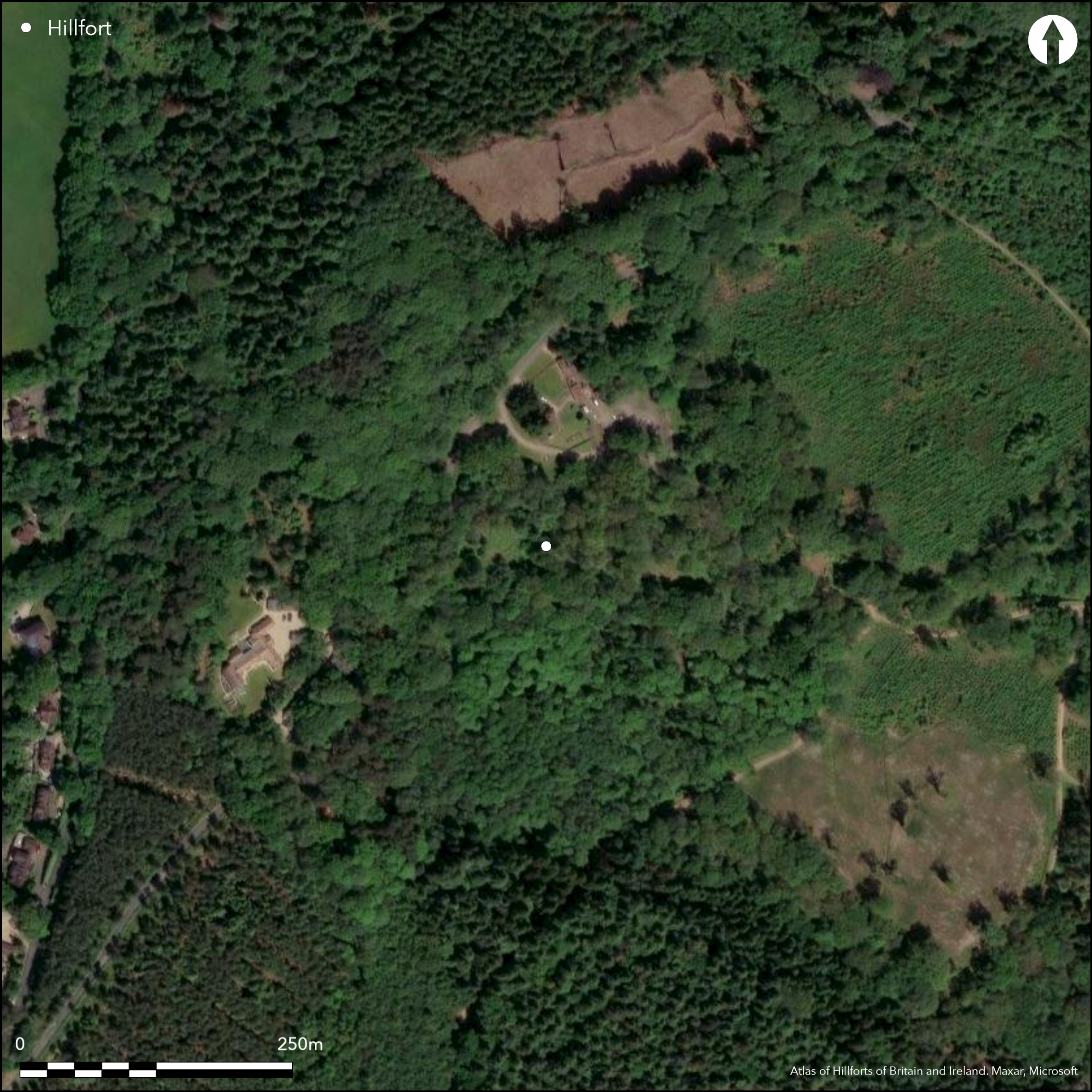
Lying on a spur to the S of Hermitage overlooking the Pang and Kennet Valleys, Grimsbury Castle is a small univallate contour fort of 3.2ha now lying in woodland. It comprises a bank, an outer ditch and counterscarp and an outwork to the W where the defences are weakest. It is roughly triangular in plan and measures approximately 542m NE-SW by 385m transversely including the outwork lying 55m to the W. Excavation has shown that the northern part of this outwork is earlier and is considered to have been a possible stock enclosure and the later southern section more massive in character (Wood 1959; 1960). The enclosing works of the main enclosure are of dump construction standing over 2m high from the bottom of the ditch, with the counterscarp more marked in the NE. Entrances with associated outworks lie in the NE and W. In the W the main bank and ditch turn slightly inwards leaving a gap of approximately 11m. The bank and counterscarp measure 2.5 and 1.0m respectively. Approximately 30m to the W of this, within the outer earthwork is a complex of banks and a banked ditch 2.5m deep, from which the outer entrance work adjoins the outwork in the W. The entrance in the NE at the apex of the triangle is 11m wide and now carries a modern road which runs through the hillfort. The original holloway associated with this entrance is visible as a 2m high double bank and ditch following the line of the modern road that becomes a double ditch as it approaches the hillfort. No internal features contemporary with the construction of the hillfort are known. An entrance recorded by Wood (1959) in the NE which leads to springs, is possibly later. An excavation c. 1860 across mounds within the interior thought to be barrows produced no archaeological material and were later deemed to be pillow mounds. Only low mounds were identified during an English Heritage survey in 2014, but their purpose deemed uncertain. A number of WWII back-filled two man slit trenches measuring 2m long by 0.8m wide within the western bank were also recorded during the survey. The enclosing works are well preserved although some quarrying has taken place across the bank in the SW and within the interior. Excavation in 1958 (Wood 1959) produced little archaeological material but a further excavation in 1960 confined to the inner, N side of the western entrance showed it to be a simple entrance possibly reinforced by a timber palisade and was probably of two periods of construction. It was subsequently strengthened by a wall of large flint blocks. Finds of 'pot boilers', sling pebbles and worked flints were recovered and a portion of a Greensand quern stone. Three very small pottery sherds identified by Sheppard Frere as deriving from the latter part of the early Iron Age dating were also recovered. The most recent scheduling amendment (30 May 2014) describes the hillfort as a promontory fort from its location on a spur, however promontory forts are classified differently by this project.
Citizen Science: ✗
Reliability of Data: Confirmed
Reliability of Interpretation: Confirmed
X: -140950 Y: 6700673 (EPSG: 3857)
Longitude: -1.266178820039259 Latitude: 51.44658307416558 (EPSG:4326)
Country: England
Current County or Unitary Authority: West Berkshire
Historic County: Berkshire
Current Parish/Community/Council/Townland: Hermitage
Some quarrying has occurred across the bank in the SW and within the interior, but otherwise a well-preserved bank and ditch.
| Extant | ✓ |
| Cropmark | ✗ |
| Likely Destroyed | ✗ |
None
| Woodland | ✓ |
| Commercial Forestry Plantation | ✗ |
| Parkland | ✗ |
| Pasture (Grazing) | ✗ |
| Arable | ✗ |
| Scrub/Bracken | ✓ |
| Bare Outcrop | ✗ |
| Heather/Moorland | ✗ |
| Heath | ✗ |
| Built-up | ✗ |
| Coastal Grassland | ✗ |
| Other | ✗ |
Univallate contour fort lying at 155m OD on plateau gravels and Bagshot sands. It occupies the highest point in a triangle of plateaus which lie between the Thames, the Kennet and the Berkshire Downs. Higher in the N, sloping in the SW towards Bucklebury Common.
| Contour Fort | ✓ |
| Partial Contour Fort | ✗ |
| Promontory Fort | ✗ |
| Hillslope Fort | ✗ |
| Level Terrain Fort | ✗ |
| Marsh Fort | ✗ |
| Multiple Enclosure Fort | ✗ |
| Hilltop | ✓ |
| Coastal Promontory | ✗ |
| Inland Promontory | ✗ |
| Valley Bottom | ✗ |
| Knoll/Hillock/Outcrop | ✗ |
| Ridge | ✗ |
| Cliff/Plateau-edge/Scarp | ✗ |
| Hillslope | ✗ |
| Lowland | ✗ |
| Spur | ✓ |
Dominant Topographic Feature: Narrow arc-shaped ridge lying to the W and S of the River Pang
| North | ✗ |
| Northeast | ✗ |
| East | ✗ |
| Southeast | ✗ |
| South | ✗ |
| Southwest | ✓ |
| West | ✗ |
| Northwest | ✗ |
| Level | ✗ |
Altitude: 155.0m
N/A
Three very small pottery sherds identified by Sheppard Frere as deriving from the latter part of the early Iron Age. Flint blade identified by Wymer as possibly Mesolithic (Wood 1959). Although possibly residual, the site lies less than 4km from several Mesolithic sites of national importance at Thatcham. Pillow mounds; quarrying; 18th century folly known as Grimsbury CastleTower. WWII slit trenches
Reliability: B - Medium
| Pre 1200BC | ✗ |
| 1200BC - 800BC | ✗ |
| 800BC - 400BC | ✓ |
| 400BC - AD50 | ✓ |
| AD50 - AD400 | ✗ |
| AD400 - AD 800 | ✗ |
| Post AD800 | ✗ |
| Unknown | ✗ |
| Pre Hillfort: | None |
| Post Hillfort: | None |
| Artefactual: | Early Iron Age pottery; quernstone, flint tools, pot boilers and possible sling shot |
| Morphology/Earthwork/Typology: | None |
The hillfort invited antiquarian interest resulting in brief reports and earthwork plans. In Aubrey's Monumenta Britannica (1665-1693). Small excavations across the ramparts and western entrance were carried out in 1957 and the 1960's. An earlier excavation in 1860 across mounds in the interior thought to be barrows produced no evidence (as reported in the notes of the proceeding of the British Archaeological Society, 1860) and were deemed to be pillow mounds during a field inspectors visit in 1963 but this interpretation is now uncertain (2014 English Heritage survey). Scheduled
| 1st Identified Map Depiction (1808): | Shown as Compton Castle on East Ilsley drawing, BL OSD 158, 2 inch to the mile |
| Earthwork Survey (1901): | Earthworks surveyed and drawn by Rev. Edward Andrews Downman. |
| Excavation (1957): | Trench across enclosing work and counterscarp in the E |
| Excavation (1960): | Confined to inner north side of western entrance |
| Other (1963): | Scheduled |
| Other (1963): | Field investigation |
| 1st Identified Written Reference (None): | None |
No contemporary features have been investigated within the interior and nothing is known
A location of a number of springs are shown by Wood (1959; Fig 2) in the north-east and south. A well in the S is reputed never to run dry
| None | ✗ |
| Spring | ✓ |
| Stream | ✗ |
| Pool | ✗ |
| Flush | ✗ |
| Well | ✓ |
| Other | ✗ |
Quarrying has caused some damage to the bank in the south-west and within the interior. Some WWII activity
| No Known Features | ✗ |
| Round Stone Structures | ✗ |
| Rectangular Stone Structures | ✗ |
| Curvilinear Platforms | ✗ |
| Other Roundhouse Evidence | ✗ |
| Pits | ✗ |
| Quarry Hollows | ✗ |
| Other | ✓ |
Pillow mounds excavated in 1860
| No Known Excavation | ✗ |
| Pits | ✗ |
| Postholes | ✗ |
| Roundhouses | ✗ |
| Rectangular Structures | ✗ |
| Roads/Tracks | ✗ |
| Quarry Hollows | ✗ |
| Other | ✓ |
| Nothing Found | ✗ |
None
| No Known Geophysics | ✓ |
| Pits | ✗ |
| Roundhouses | ✗ |
| Rectangular Structures | ✗ |
| Roads/Tracks | ✗ |
| Quarry Hollows | ✗ |
| Other | ✗ |
| Nothing Found | ✗ |
Early Iron Age pottery; quernstone, flint tools, pot boilers and possible sling shot
| No Known Finds | ✗ |
| Pottery | ✓ |
| Metal | ✗ |
| Metalworking | ✗ |
| Human Bones | ✗ |
| Animal Bones | ✗ |
| Lithics | ✓ |
| Environmental | ✗ |
| Other | ✓ |
Wooded
| APs Not Checked | ✓ |
| None | ✗ |
| Roundhouses | ✗ |
| Rectangular Structures | ✗ |
| Pits | ✗ |
| Postholes | ✗ |
| Roads/Tracks | ✗ |
| Other | ✗ |
Entrances with associated outworks lie in the NE and W. In the W the main bank and ditch turn slightly inwards leaving a gap of approximately 11m. The bank and counterscarp measure 2.5 and 1.0m respectively. Approximately 30m to the W of this, within the outer earthwork is a complex of banks and a banked ditch 2.5m deep, from which the outer entrance work adjoins the outwork in the W. The entrance in the NE at the apex of the triangle is 11m wide and now carries a modern road which runs through the hillfort. No internal features contemporary with the construction of the hillfort are known. An entrance recorded by Wood (1959) in the NE which leads to springs is possibly later.
| 3: | None |
| 2: | It is uncertain if the entrance in the NE is original |
Guard Chambers: ✗
Chevaux de Frise: ✗
| 1. In-turned (West): | Simple entrance, but slightly inturned mid-way along the western side, approached by sunken tracks. Excavated evidence suggests more than one phase of construction with a timber palisade subsequently strengthened by a flint wall. |
| 2. Outworks (North): | Possibly additional outworks, now carries a modern road |
| 3. Simple Gap (North east): | Leads to springs and possibly original |
Small univallate contour fort of 3.2ha now lying in woodland. It comprises a bank, an outer ditch and counterscarp and an outwork to the W where the defences are weakest. It is roughly triangular in plan and measures approximately 542m NE-SW by 385m transversely including the outwork lying 55m to the W. The enclosing works of the main enclosure are of dump construction standing over 2m high from the bottom of the ditch, with a marked counterscarp in the NE.
| Area 1: | 3.2ha. |
| Total: | 3.2ha. |
Total Footprint Area: Noneha.
The bank is of univallate dump construction with a marked counterscarp in the north-east and approximately 3m deep ditch with an internal step where excavated. A further earthwork follows the western side along the weakest part of the defences.
| ✗ | None |
| ✓ | It was observed by Wood (1958) that along the easiest approach to the hillfort in the region of the south-west corner the enclosing works were at their strongest and appear to have been strengthened by the addition of an outer bank on the side of easiest access. Conversely on the south overlooking the steepest slope and coinciding with springs and a boggy area the banks weak with the inner bank replaced by a scarped slope. |
| NE Quadrant: | 1 |
| SE Quadrant: | 1 |
| SW Quadrant: | 1 |
| NW Quadrant: | 1 |
| Total: | 1 |
| Partial Univallate | ✗ |
| Univallate | ✓ |
| Partial Bivallate | ✗ |
| Bivallate | ✗ |
| Partial Multivallate | ✗ |
| Multivallate | ✗ |
| Unknown | ✗ |
| Partial Univallate | ✗ |
| Univallate | ✗ |
| Partial Bivallate | ✗ |
| Bivallate | ✗ |
| Partial Multivallate | ✗ |
| Multivallate | ✗ |
None
| None | ✗ |
| Earthen Bank | ✓ |
| Stone Wall | ✗ |
| Rubble | ✗ |
| Wall-walk | ✗ |
| Evidence of Timber | ✗ |
| Vitrification | ✗ |
| Other Burning | ✗ |
| Palisade | ✗ |
| Counter Scarp Bank | ✓ |
| Berm | ✗ |
| Unfinished | ✗ |
| Other | ✗ |
Excavation in the west provided evidence for a bank which was possibly reinforced with a timber palisade and later strengthened by a flint wall
| None | ✗ |
| Earthen Bank | ✓ |
| Stone Wall | ✓ |
| Murus Duplex | ✗ |
| Timber-framed | ✗ |
| Timber-laced | ✗ |
| Vitrification | ✗ |
| Other Burning | ✗ |
| Palisade | ✓ |
| Counter Scarp Bank | ✓ |
| Berm | ✗ |
| Unfinished | ✗ |
| No Known Excavation | ✗ |
| Other | ✗ |
| ✗ | None |
| ✓ | 3m deep ditch with an internal step |
Number of Ditches: 1
| ✗ | None |
Gray, E.W. 1839: The History and Antiquities of Newbury and its Environs; Also a Catalogue of Plants Found in the Neighbourhood. 218-220. Speenhamland. Hall and Marsh.
Wood, P. 1959: The Early Iron Age Camp called Grimsbury Castle, near Hermitage, Berks. Berkshire Archaeol J: 57, 74-82
Wood, P. 1960 Excavations at Grimsbury Castle near Hermitage, Berks. Trans Newbury Dist Fld Club. Vol. 11, no. 2 , 3-61
Anon. 1860. The Archaeology of Berkshire. J Brit Archaeol Ass 16, 1860: 229-30
Atlas of Hillforts:
Wikidata:
This work is licensed under CC BY-SA 4.0![]()
![]()
![]() and should be cited as:
and should be cited as:
Lock, Gary and Ralston, Ian. 2024. Atlas of Hillforts of Britain and Ireland. Available at: https://hillforts.arch.ox.ac.uk
Document Version 1.1