LiDAR 1m DTM Hillshade
Satellite Imagery
LiDAR 1m DTM Hillshade
Satellite Imagery
Scroll left/right to view further images.
HER: West Berkshire MWB1560 (None)
NMR: SU 47 SE 3 (233520)
SM: 1006984
NGR: SU 4672 7243
X: 446720 Y: 172433 (OSGB36)
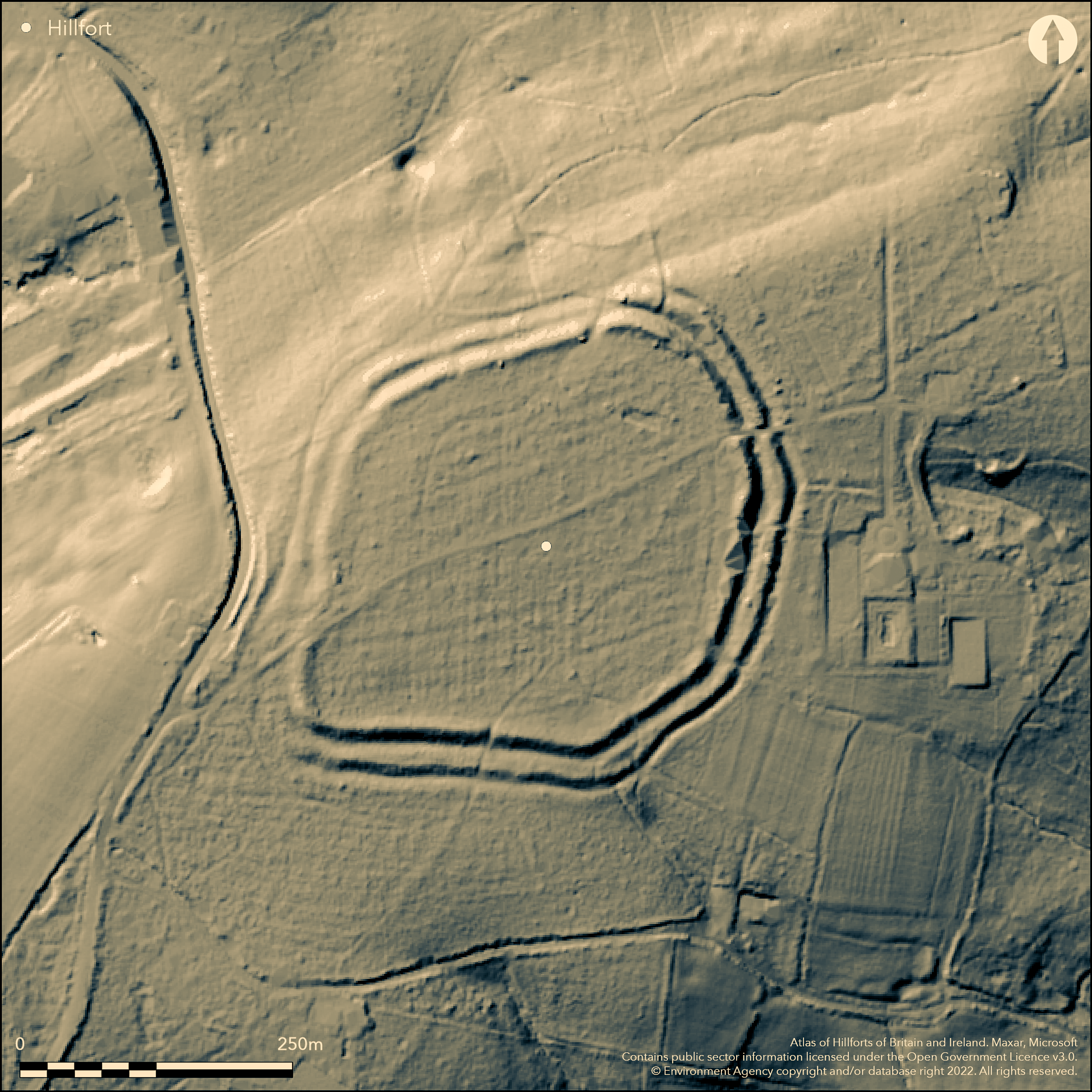
North of Snelsmore Common in Bussock Wood, a subcircular partially bivallate hillfort lying on a plateau at the end of a gravelly ridge. The defences are univallate in the N and W and bivallate elsewhere, with banks spaced approximately 17m apart with a deep ditch between and follow the steep natural slope in the N and W. A further short length of ditch has been recorded in the E. Four entrances have been reported but only three were clearly visible at the beginning of the 20th century, with only the northern entrance considered original. The ramparts are now considerably denuded and there has been ground disturbance through gravel quarrying. The site is unexcavated and the date of construction or presence of internal features is unknown. Recorded on 1885-1900 1st Ed OS mapping. Scheduled
Citizen Science: ✗
Reliability of Data: Confirmed
Reliability of Interpretation: Confirmed
X: -147953 Y: 6701088 (EPSG: 3857)
Longitude: -1.3290860238909816 Latitude: 51.448911165938874 (EPSG:4326)
Country: England
Current County or Unitary Authority: West Berkshire
Historic County: Berkshire
Current Parish/Community/Council/Townland: Chieveley
The ramparts are now denuded and damage has occurred probably through gravel quarrying. The banks were said to have stood at 3.6m in the N and 6.1m high in the W Cotton (1962: 45)
| Extant | ✓ |
| Cropmark | ✗ |
| Likely Destroyed | ✗ |
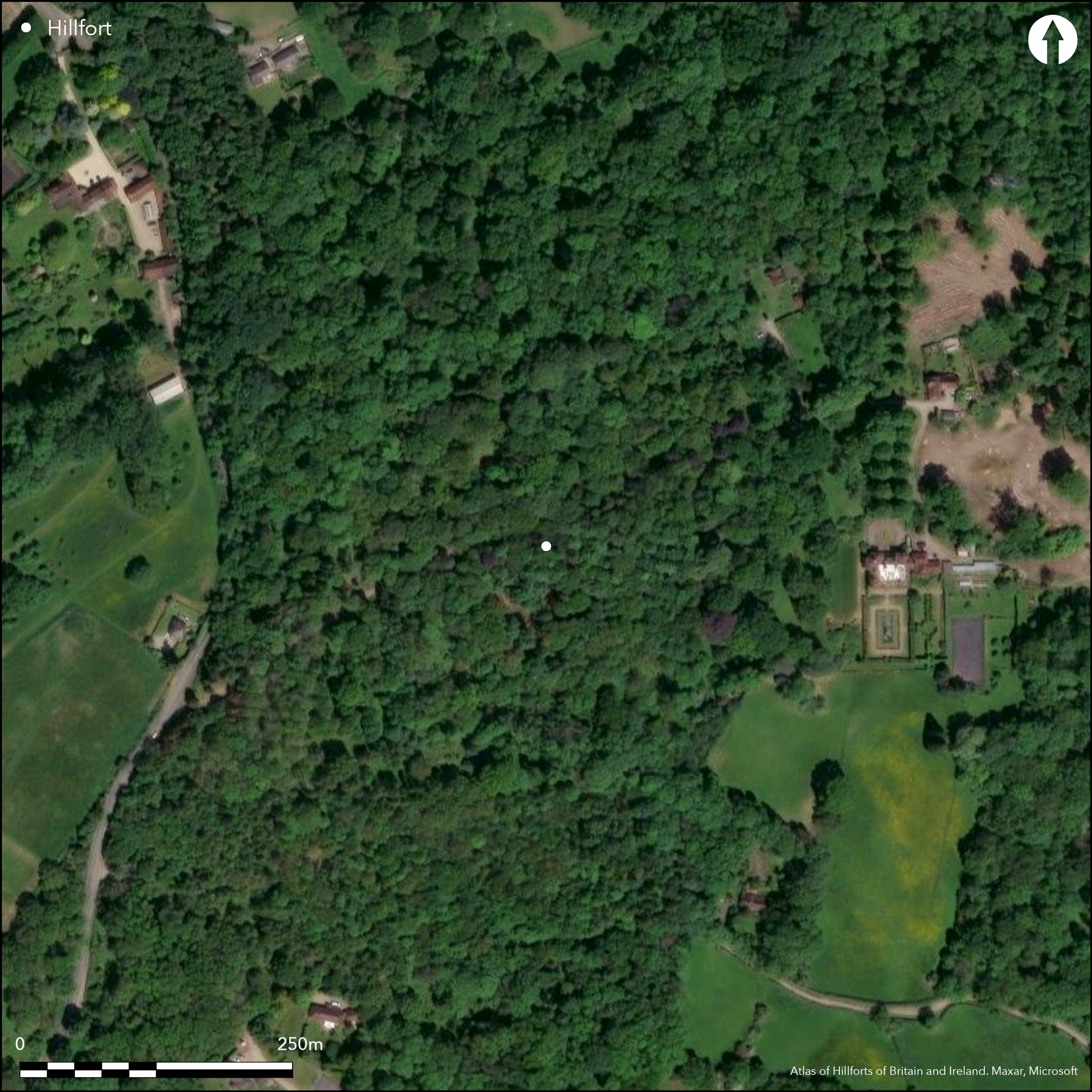
Lies within the grounds of a 20th century country house
| Woodland | ✓ |
| Commercial Forestry Plantation | ✗ |
| Parkland | ✗ |
| Pasture (Grazing) | ✗ |
| Arable | ✗ |
| Scrub/Bracken | ✗ |
| Bare Outcrop | ✗ |
| Heather/Moorland | ✗ |
| Heath | ✗ |
| Built-up | ✗ |
| Coastal Grassland | ✗ |
| Other | ✗ |
A contour fort, univallate in the W and bivallate elsewhere lying on a ridge at 145m OD
| Contour Fort | ✓ |
| Partial Contour Fort | ✗ |
| Promontory Fort | ✗ |
| Hillslope Fort | ✗ |
| Level Terrain Fort | ✗ |
| Marsh Fort | ✗ |
| Multiple Enclosure Fort | ✗ |
| Hilltop | ✗ |
| Coastal Promontory | ✗ |
| Inland Promontory | ✗ |
| Valley Bottom | ✗ |
| Knoll/Hillock/Outcrop | ✗ |
| Ridge | ✓ |
| Cliff/Plateau-edge/Scarp | ✗ |
| Hillslope | ✗ |
| Lowland | ✗ |
| Spur | ✗ |
Dominant Topographic Feature: Situated at the end of a gravelly ridge which has a steep natural slope to the N and W.
| North | ✗ |
| Northeast | ✗ |
| East | ✗ |
| Southeast | ✗ |
| South | ✗ |
| Southwest | ✗ |
| West | ✗ |
| Northwest | ✗ |
| Level | ✓ |
Altitude: 145.0m
N/A
Unexcavated, presumed Iron Age
Reliability: D - None
| Pre 1200BC | ✗ |
| 1200BC - 800BC | ✗ |
| 800BC - 400BC | ✗ |
| 400BC - AD50 | ✗ |
| AD50 - AD400 | ✗ |
| AD400 - AD 800 | ✗ |
| Post AD800 | ✗ |
| Unknown | ✓ |
| Pre Hillfort: | None |
| Post Hillfort: | None |
In Aubrey's Monumenta Britannica (1665-1693). On OS 1st Ed map (1885-1900). Field investigation in 1963. The site is unexcavated. Gelling (1973: 277) suggests the name Bussock is Old English for buscuc 'place overgrown with bushes'. Scheduled
| Other (1963): | Field investigation |
| 1st Identified Written Reference (None): | None |
| 1st Identified Map Depiction (None): | OS one inch |
| Other (None): | Scheduled |
The hillfort is now wooded and interior features are unknown. Calcined flints and possible pot-boilers found during an excursion of the Newbury District Field Club (1872-5)
None
| None | ✓ |
| Spring | ✗ |
| Stream | ✗ |
| Pool | ✗ |
| Flush | ✗ |
| Well | ✗ |
| Other | ✗ |
None
| No Known Features | ✓ |
| Round Stone Structures | ✗ |
| Rectangular Stone Structures | ✗ |
| Curvilinear Platforms | ✗ |
| Other Roundhouse Evidence | ✗ |
| Pits | ✗ |
| Quarry Hollows | ✗ |
| Other | ✗ |
None
| No Known Excavation | ✓ |
| Pits | ✗ |
| Postholes | ✗ |
| Roundhouses | ✗ |
| Rectangular Structures | ✗ |
| Roads/Tracks | ✗ |
| Quarry Hollows | ✗ |
| Other | ✗ |
| Nothing Found | ✗ |
None
| No Known Geophysics | ✓ |
| Pits | ✗ |
| Roundhouses | ✗ |
| Rectangular Structures | ✗ |
| Roads/Tracks | ✗ |
| Quarry Hollows | ✗ |
| Other | ✗ |
| Nothing Found | ✗ |
Calcined flints and possible pot-boilers found during an excursion of the Newbury District Field Club (1872-5)
| No Known Finds | ✗ |
| Pottery | ✗ |
| Metal | ✗ |
| Metalworking | ✗ |
| Human Bones | ✗ |
| Animal Bones | ✗ |
| Lithics | ✓ |
| Environmental | ✗ |
| Other | ✓ |
In woodland
| APs Not Checked | ✓ |
| None | ✗ |
| Roundhouses | ✗ |
| Rectangular Structures | ✗ |
| Pits | ✗ |
| Postholes | ✗ |
| Roads/Tracks | ✗ |
| Other | ✗ |
Four entrances were reported but only three were clearly visible at the beginning of the 20th century, with only the one in the N considered original
| 4: | None |
| 2: | None |
Guard Chambers: ✗
Chevaux de Frise: ✗
| 1. Simple Gap (North): | None |
The defences are univallate in the N and W facing steeper ground and bivallate elsewhere where the approach is more accessible. The banks are spaced approximately 17m apart with a deep ditch between. A further short length of ditch has been recorded in the east. The ramparts follow the steep natural slope in the N and W.
| Area 1: | 3.9ha. |
| Total: | 3.9ha. |
Total Footprint Area: 4.4ha.
None
| ✗ | None |
| ✓ | None |
| NE Quadrant: | 2 |
| SE Quadrant: | 2 |
| SW Quadrant: | 1 |
| NW Quadrant: | 1 |
| Total: | 2 |
| Partial Univallate | ✓ |
| Univallate | ✗ |
| Partial Bivallate | ✓ |
| Bivallate | ✗ |
| Partial Multivallate | ✗ |
| Multivallate | ✗ |
| Unknown | ✗ |
| Partial Univallate | ✗ |
| Univallate | ✗ |
| Partial Bivallate | ✗ |
| Bivallate | ✗ |
| Partial Multivallate | ✗ |
| Multivallate | ✗ |
None
| None | ✗ |
| Earthen Bank | ✓ |
| Stone Wall | ✗ |
| Rubble | ✗ |
| Wall-walk | ✗ |
| Evidence of Timber | ✗ |
| Vitrification | ✗ |
| Other Burning | ✗ |
| Palisade | ✗ |
| Counter Scarp Bank | ✗ |
| Berm | ✗ |
| Unfinished | ✗ |
| Other | ✗ |
None
| None | ✗ |
| Earthen Bank | ✗ |
| Stone Wall | ✗ |
| Murus Duplex | ✗ |
| Timber-framed | ✗ |
| Timber-laced | ✗ |
| Vitrification | ✗ |
| Other Burning | ✗ |
| Palisade | ✗ |
| Counter Scarp Bank | ✗ |
| Berm | ✗ |
| Unfinished | ✗ |
| No Known Excavation | ✓ |
| Other | ✗ |
| ✗ | Further short length of ditch recorded in the E. |
| ✓ | None |
Number of Ditches: 2
| ✗ | None |
Cotton, M. A. 1962. Berkshire Hill Forts. Berkshire Archaeol J. 60: 30-52
Gelling, M. 1975. The Place-Names of Berkshire Pt I. English Place-Name Society. Cambridge University Press
Anon. 1872-75. Excursion to Shaw, Donnington, Bussock Camp, Chaddleworth & Poughley Monastery, 1872. Trans Newbury Dist Fld Club: 2. 2. p14-17
Atlas of Hillforts:
Wikidata:
This work is licensed under CC BY-SA 4.0![]()
![]()
![]() and should be cited as:
and should be cited as:
Lock, Gary and Ralston, Ian. 2024. Atlas of Hillforts of Britain and Ireland. Available at: https://hillforts.arch.ox.ac.uk
Document Version 1.1