LiDAR 1m DTM Hillshade
Satellite Imagery
LiDAR 1m DTM Hillshade
Satellite Imagery
Scroll left/right to view further images.
HER: West Berkshire MWB2645 (None)
NMR: SU 56 NW 3 (237035)
SM: None
NGR: SU 52469 69532
X: 452469 Y: 169532 (OSGB36)
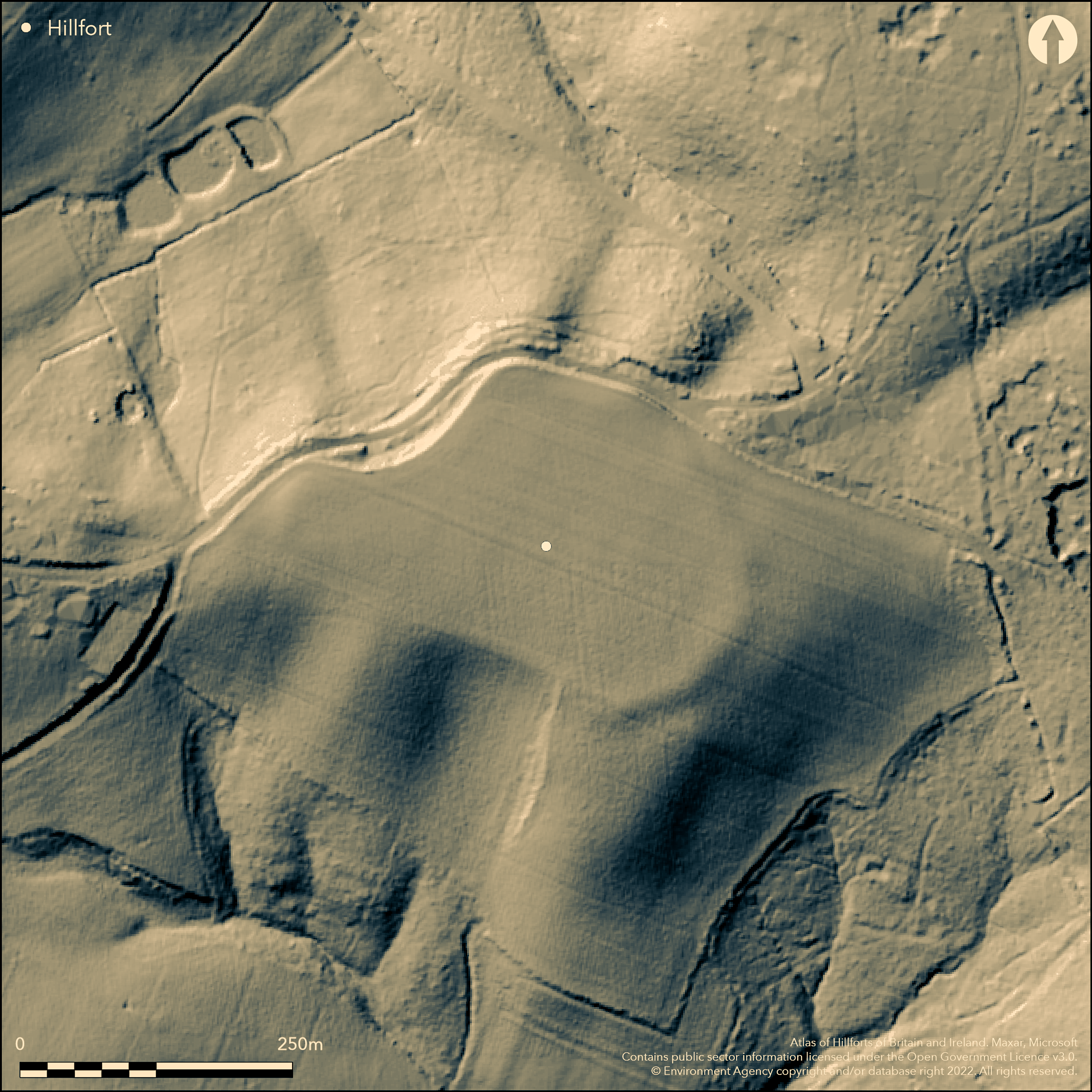
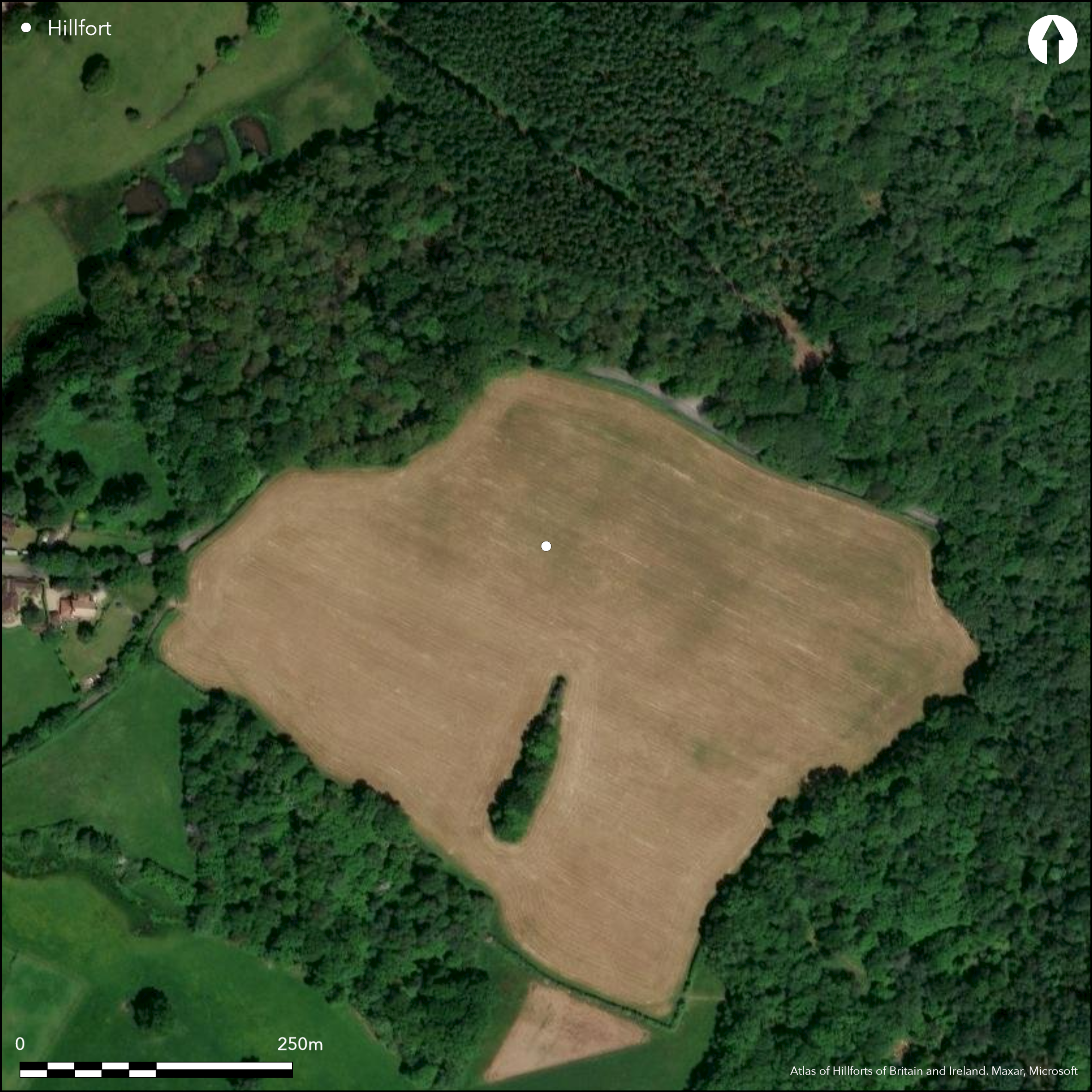
To the SE of the village of Cold Ash a possible univallate earthwork of 2.8ha (measurement approximate), first discovered from aerial photographs in 1948 as a semi-circular cropmark lying in a strong defensive position on a ridge of high ground. The earthworks, which comprise a bank and ditch, survive in woodland in the N and E but elsewhere are now partially destroyed under arable cultivation. The ditch can be seen as a cropmark on open ground. The location of entrances or the presence of interior features is unknown. It was assumed by Cotton (1962) and Hogg (1979) to be a hillfort although it is uncertain if it was ever completed. Excavations in 1949 (Hadcock 1949-50) revealed a ploughed-down bank of probable dump construction with flints and a U-shaped ditch. No dating evidence was recovered for its period of construction and use. The site is recorded on 1931-61 OS mapping
Citizen Science: ✗
Reliability of Data: Confirmed
Reliability of Interpretation: Unconfirmed
X: -138792 Y: 6696341 (EPSG: 3857)
Longitude: -1.2467917344119517 Latitude: 51.42232580489809 (EPSG:4326)
Country: England; None
Current County or Unitary Authority: West Berkshire
Historic County: Berkshire
Current Parish/Community/Council/Townland: Thatcham; Cold Ash and Bucklebury
Survives as a bank lying in Ramsbury Wood in the N and E but ploughed out in the S-W and only visible on aerial photographs
| Extant | ✓ |
| Cropmark | ✓ |
| Likely Destroyed | ✗ |
Plateau gravel and sands
| Woodland | ✓ |
| Commercial Forestry Plantation | ✗ |
| Parkland | ✗ |
| Pasture (Grazing) | ✗ |
| Arable | ✓ |
| Scrub/Bracken | ✗ |
| Bare Outcrop | ✗ |
| Heather/Moorland | ✗ |
| Heath | ✗ |
| Built-up | ✗ |
| Coastal Grassland | ✗ |
| Other | ✗ |
A possible former contour fort lying at approximately 149m OD. The northern side survives as two parallel banks in adjacent woodland which follow the contours of a steep slope for several metres (verified by the West Berkshire HER officer in 2011)
| Contour Fort | ✓ |
| Partial Contour Fort | ✗ |
| Promontory Fort | ✗ |
| Hillslope Fort | ✗ |
| Level Terrain Fort | ✗ |
| Marsh Fort | ✗ |
| Multiple Enclosure Fort | ✗ |
| Hilltop | ✓ |
| Coastal Promontory | ✗ |
| Inland Promontory | ✗ |
| Valley Bottom | ✗ |
| Knoll/Hillock/Outcrop | ✗ |
| Ridge | ✓ |
| Cliff/Plateau-edge/Scarp | ✗ |
| Hillslope | ✗ |
| Lowland | ✗ |
| Spur | ✗ |
Dominant Topographic Feature: Lies in a strong defensive position on a ridge of high ground.
| North | ✗ |
| Northeast | ✗ |
| East | ✗ |
| Southeast | ✗ |
| South | ✗ |
| Southwest | ✗ |
| West | ✗ |
| Northwest | ✗ |
| Level | ✓ |
Altitude: 149.0m
Although situated entirely in Thatcham it lies at the junction of three parishes, Thatcham, Cold Ash and Bucklebury
Boundary Type: Parish/Townland
Undated, presumed Iron Age. A medieval drain, formed from a horseshoe-shaped pipe resting on flat tiles, ran across the bottom, post-dating the construction of the enclosure ditch.
Reliability: D - None
| Pre 1200BC | ✗ |
| 1200BC - 800BC | ✗ |
| 800BC - 400BC | ✗ |
| 400BC - AD50 | ✗ |
| AD50 - AD400 | ✗ |
| AD400 - AD 800 | ✗ |
| Post AD800 | ✗ |
| Unknown | ✓ |
| Pre Hillfort: | None |
| Post Hillfort: | None |
A fragment of ditch in the N-E partially following the 149m contour is recorded on the 1:25,000 1931-61 OS map. Discovered on 1948 aerial photograph. Excavations showed a ploughed-down bank of probable dump construction and a U-shaped dtich (Hadcock 1948-50). No dating evidence was recovered
| Other (1948): | Discovered from aerial photograph |
| Excavation (1949): | No dating evidence recovered |
| 1st Identified Map Depiction (None): | None |
Mostly destroyed, no evidence for interior features
A number of springs rise in the area
| None | ✓ |
| Spring | ✗ |
| Stream | ✗ |
| Pool | ✗ |
| Flush | ✗ |
| Well | ✗ |
| Other | ✗ |
None
| No Known Features | ✓ |
| Round Stone Structures | ✗ |
| Rectangular Stone Structures | ✗ |
| Curvilinear Platforms | ✗ |
| Other Roundhouse Evidence | ✗ |
| Pits | ✗ |
| Quarry Hollows | ✗ |
| Other | ✗ |
Ramparts only excavated
| No Known Excavation | ✓ |
| Pits | ✗ |
| Postholes | ✗ |
| Roundhouses | ✗ |
| Rectangular Structures | ✗ |
| Roads/Tracks | ✗ |
| Quarry Hollows | ✗ |
| Other | ✗ |
| Nothing Found | ✗ |
None
| No Known Geophysics | ✓ |
| Pits | ✗ |
| Roundhouses | ✗ |
| Rectangular Structures | ✗ |
| Roads/Tracks | ✗ |
| Quarry Hollows | ✗ |
| Other | ✗ |
| Nothing Found | ✗ |
None
| No Known Finds | ✓ |
| Pottery | ✗ |
| Metal | ✗ |
| Metalworking | ✗ |
| Human Bones | ✗ |
| Animal Bones | ✗ |
| Lithics | ✗ |
| Environmental | ✗ |
| Other | ✗ |
None
| APs Not Checked | ✗ |
| None | ✓ |
| Roundhouses | ✗ |
| Rectangular Structures | ✗ |
| Pits | ✗ |
| Postholes | ✗ |
| Roads/Tracks | ✗ |
| Other | ✗ |
The location of entrances is unknown
| None: | Unknown |
| 2: | Unknown |
Guard Chambers: ✗
Chevaux de Frise: ✗
Low banks running for several metres were observed in 2011 by West Berkshire HER Officer on the northern side of the enclosure running along the contours of a steep slope now in woodland. A possible ditch survives in the E. A small excavation showed a ploughed down bank of simple dump construction and a U-shaped ditch. The ditch had an internal step.
| Area 1: | 2.4ha. |
| Total: | 2.4ha. |
Total Footprint Area: Noneha.
Low banks running for several metres were observed in 2011 by West Berkshire HER Officer on the northern side of the enclosure running along the contours of a steep slope now in woodland. A possible ditch survives in the east. A small excavation showed a ploughed down bank of simple dump construction and a U-shaped ditch. The ditch had an internal step.
| ✗ | Enclosed area estimated by Hogg (1979) |
| ✗ | Survive as two parallel banks in N and E. Only the ditch survives as cropmark elsewhere |
| NE Quadrant: | 1 |
| SE Quadrant: | None |
| SW Quadrant: | None |
| NW Quadrant: | None |
| Total: | 1 |
| Partial Univallate | ✓ |
| Univallate | ✗ |
| Partial Bivallate | ✗ |
| Bivallate | ✗ |
| Partial Multivallate | ✗ |
| Multivallate | ✗ |
| Unknown | ✗ |
| Partial Univallate | ✗ |
| Univallate | ✗ |
| Partial Bivallate | ✗ |
| Bivallate | ✗ |
| Partial Multivallate | ✗ |
| Multivallate | ✗ |
None
| None | ✗ |
| Earthen Bank | ✓ |
| Stone Wall | ✗ |
| Rubble | ✗ |
| Wall-walk | ✗ |
| Evidence of Timber | ✗ |
| Vitrification | ✗ |
| Other Burning | ✗ |
| Palisade | ✗ |
| Counter Scarp Bank | ✗ |
| Berm | ✗ |
| Unfinished | ✗ |
| Other | ✗ |
Where excavated bank was found to be formed from sandy soils and clay with flints. Possibly unfinished
| None | ✗ |
| Earthen Bank | ✓ |
| Stone Wall | ✗ |
| Murus Duplex | ✗ |
| Timber-framed | ✗ |
| Timber-laced | ✗ |
| Vitrification | ✗ |
| Other Burning | ✗ |
| Palisade | ✗ |
| Counter Scarp Bank | ✗ |
| Berm | ✗ |
| Unfinished | ✓ |
| No Known Excavation | ✗ |
| Other | ✗ |
| ✗ | None |
| ✓ | A fragment of ditch in the N-E partially following the 149m contour is recorded on the 1:25,000 1931-61 OS map |
Number of Ditches: 1
| ✗ | None |
Hadcock, N. 1948-50. Earthwork at Ramsbury Corner, Bucklebury. Trans Newbury Dist Fld Club .9 24-25 Plan.
Cotton, M. A. 1962. Berkshire Hill Forts. Berkshire Archaeol .J 60: 30-52
Hogg, A.H.A. 1979. British Hill-Forts. An Index. British Archaeological Reports, British Series 62. 211
Atlas of Hillforts:
Wikidata:
This work is licensed under CC BY-SA 4.0![]()
![]()
![]() and should be cited as:
and should be cited as:
Lock, Gary and Ralston, Ian. 2024. Atlas of Hillforts of Britain and Ireland. Available at: https://hillforts.arch.ox.ac.uk
Document Version 1.1