LiDAR 1m DTM Hillshade
Satellite Imagery
LiDAR 1m DTM Hillshade
Satellite Imagery
Scroll left/right to view further images.
HER: Wiltshire and Swindon MWI430213 (MWB3075); West Berkshire MWB3075
NMR: SU 37 NW 6 (228970)
SM: 1003818
NGR: SU 30214 75285
X: 430214 Y: 175285 (OSGB36)
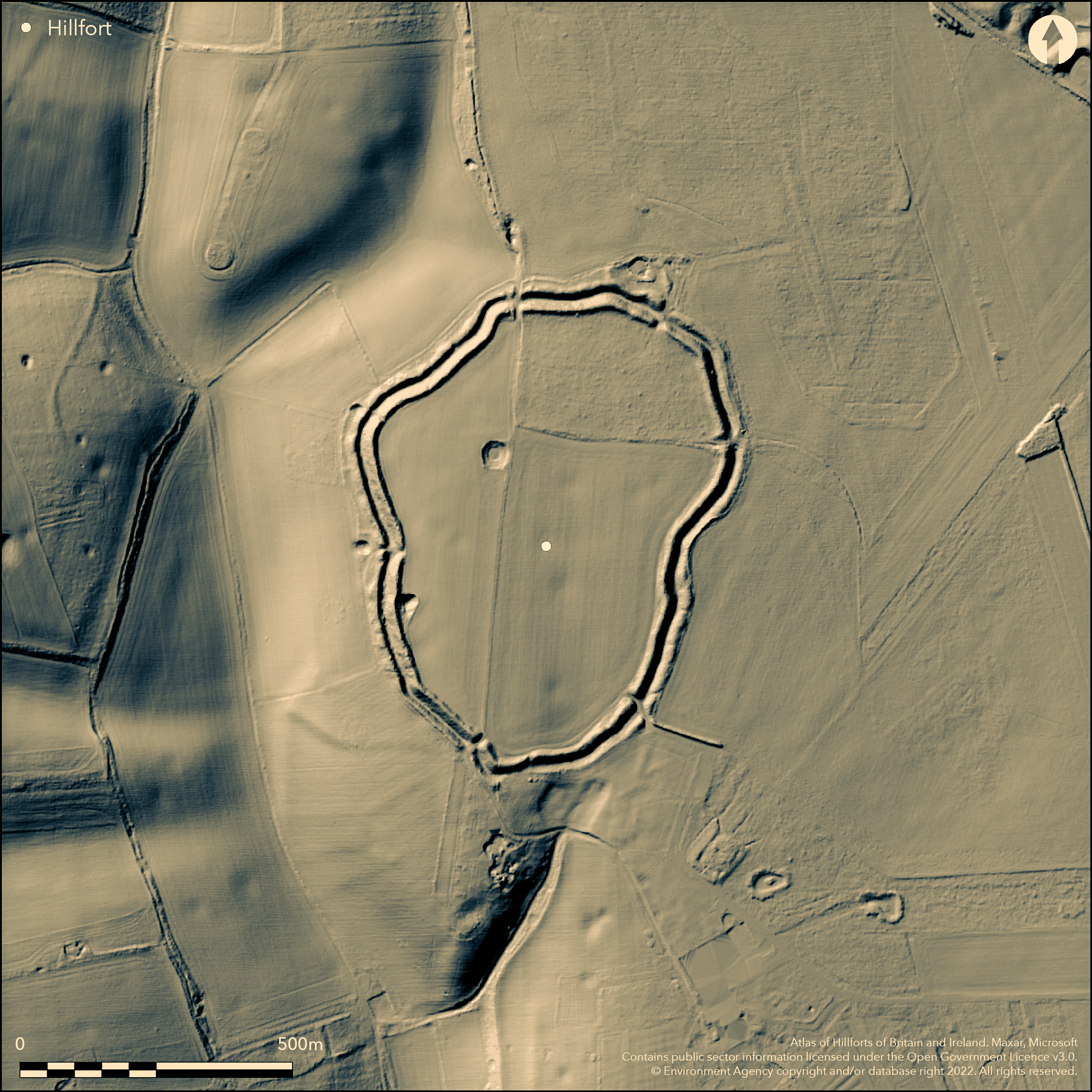
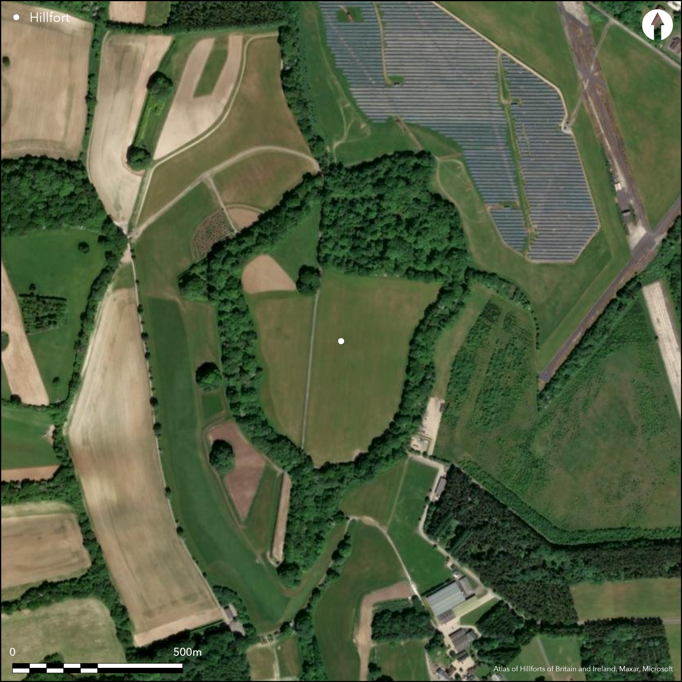
Large, oval, contour hillfort located at SW corner of small downland plateau with River Kennet to SW and Ermin Street to NE. Steep slopes to S; flat plateau to N and E. Two banks with medial ditch visible with possible buried outer ditch not determined. Measures 390m by 490m, with internal area 13.75ha. Bank running into E side of fort possibly boundary earthwork. Gap on NE with flanking earthwork on W probably original inturned entrance; other gaps modern. In S interior possible hut circle c. 12m diameter showing as cropmark. Unexcavated, but chance finds of possible Iron Age pottery 1977, 1980 and 1987 and Neolithic chipped and polished grey flint axe and Neolithic or later grey flint adze or chisel, both in Passmore Collection, Ashmolean Museum, Oxford. E side of fort part destroyed by WWII airfield and interior ploughed with overgrown wooded ramparts. On Ist Ed. OS map (1882).
Citizen Science: ✗
Reliability of Data: Confirmed
Reliability of Interpretation: Confirmed
X: -174367 Y: 6705870 (EPSG: 3857)
Longitude: -1.5663623832398705 Latitude: 51.47567332489111 (EPSG:4326)
Country: England; None
Current County or Unitary Authority: Wiltshire; West Berkshire
Historic County: Wiltshire; Berkshire
Current Parish/Community/Council/Townland: Ramsbury; Lambourn
E side of fort part destroyed by WWII airfield and interior ploughed with overgrown wooded ramparts. On Heritage at Risk Register (2015).
| Extant | ✓ |
| Cropmark | ✗ |
| Likely Destroyed | ✓ |
Cultivated interior with wooded and overgrown ramparts. WWII airfield.
| Woodland | ✓ |
| Commercial Forestry Plantation | ✗ |
| Parkland | ✗ |
| Pasture (Grazing) | ✓ |
| Arable | ✓ |
| Scrub/Bracken | ✓ |
| Bare Outcrop | ✗ |
| Heather/Moorland | ✗ |
| Heath | ✗ |
| Built-up | ✓ |
| Coastal Grassland | ✗ |
| Other | ✓ |
Large, oval, contour hillfort located at the SW corner of small downland plateau at 206m OD with the River Kennet to the SW and Ermin Street to the NE. Steep slopes to S and W and flat plateau to N and E.
| Contour Fort | ✓ |
| Partial Contour Fort | ✗ |
| Promontory Fort | ✗ |
| Hillslope Fort | ✗ |
| Level Terrain Fort | ✗ |
| Marsh Fort | ✗ |
| Multiple Enclosure Fort | ✗ |
| Hilltop | ✗ |
| Coastal Promontory | ✗ |
| Inland Promontory | ✗ |
| Valley Bottom | ✗ |
| Knoll/Hillock/Outcrop | ✗ |
| Ridge | ✗ |
| Cliff/Plateau-edge/Scarp | ✓ |
| Hillslope | ✗ |
| Lowland | ✗ |
| Spur | ✗ |
Dominant Topographic Feature: Downland plateau
| North | ✗ |
| Northeast | ✗ |
| East | ✗ |
| Southeast | ✗ |
| South | ✗ |
| Southwest | ✗ |
| West | ✗ |
| Northwest | ✗ |
| Level | ✓ |
Altitude: 206.0m
Greater part of site in Wiltshire; that to NE pre 1974 formerly in Berkshire, now in West Berkshire.
Boundary Type: County
Chance finds of possible Iron Age pottery.
Reliability: C - Low
| Pre 1200BC | ✗ |
| 1200BC - 800BC | ✗ |
| 800BC - 400BC | ✗ |
| 400BC - AD50 | ✓ |
| AD50 - AD400 | ✗ |
| AD400 - AD 800 | ✗ |
| Post AD800 | ✗ |
| Unknown | ✗ |
| Pre Hillfort: | None |
| Post Hillfort: | None |
| Artefactual: | Possible Iron Age pottery. |
On Ist Ed. OS map (1882). 1999-2000 RCHME aerial photograph interpretation as part of Lambourn Downs NMP.
| 1st Identified Map Depiction (1882): | OS map |
| Other (None): | RCHME aerial photograph interpretation as part of Lambourn Downs NMP. |
Unexcavated, but chance finds of possible Iron Age pottery 1977, 1980 and 1987 and Neolithic chipped and polished grey flint axe and Neolithic or later grey flint adze or chisel, both in Passmore Collection, Ashmolean Museum, Oxford. In S interior possible hut circle c. 12m diameter showing as cropmark.
None
| None | ✓ |
| Spring | ✗ |
| Stream | ✗ |
| Pool | ✗ |
| Flush | ✗ |
| Well | ✗ |
| Other | ✗ |
In S interior possible hut circle c. 12m diameter showing as cropmark.
| No Known Features | ✓ |
| Round Stone Structures | ✗ |
| Rectangular Stone Structures | ✗ |
| Curvilinear Platforms | ✗ |
| Other Roundhouse Evidence | ✗ |
| Pits | ✗ |
| Quarry Hollows | ✗ |
| Other | ✗ |
None
| No Known Excavation | ✓ |
| Pits | ✗ |
| Postholes | ✗ |
| Roundhouses | ✗ |
| Rectangular Structures | ✗ |
| Roads/Tracks | ✗ |
| Quarry Hollows | ✗ |
| Other | ✗ |
| Nothing Found | ✗ |
None
| No Known Geophysics | ✓ |
| Pits | ✗ |
| Roundhouses | ✗ |
| Rectangular Structures | ✗ |
| Roads/Tracks | ✗ |
| Quarry Hollows | ✗ |
| Other | ✗ |
| Nothing Found | ✗ |
Unexcavated, but chance finds of possoble Iron Age pottery 1977, 1980 and 1987 and Neolithic chipped and polished grey flint axe and Neolithic or later grey flint adze or chisel, both in Passmore Collection, Ashmolean Museum, Oxford.
| No Known Finds | ✗ |
| Pottery | ✓ |
| Metal | ✗ |
| Metalworking | ✗ |
| Human Bones | ✗ |
| Animal Bones | ✗ |
| Lithics | ✓ |
| Environmental | ✗ |
| Other | ✗ |
In S interior possible hut circle c. 12m diameter showing as cropmark.
| APs Not Checked | ✗ |
| None | ✗ |
| Roundhouses | ✓ |
| Rectangular Structures | ✗ |
| Pits | ✗ |
| Postholes | ✗ |
| Roads/Tracks | ✗ |
| Other | ✗ |
Overgrown and mutilated gap on NE with flanking earthwork on W probably original inturned entrance; Five other modern gaps, especially where county boundary passes through site on N and E.
| 6: | Five modern gaps, especially where county boundary passes through site on N and E. |
| 2: | Original entrance on NE side. |
Guard Chambers: ✗
Chevaux de Frise: ✗
| 1. In-turned (North east): | Overgrown and mutilated. |
Two banks with medial ditch visible with possible buried outer ditch not determined. Measures 390m by 490m. Bank running into E side of fort possibly boundary earthwork.
| Area 1: | 13.8ha. |
| Total: | 13.8ha. |
Total Footprint Area: Noneha.
None
| ✗ | None |
| ✓ | Part destroyed on E side. |
| NE Quadrant: | 2 |
| SE Quadrant: | 2 |
| SW Quadrant: | 2 |
| NW Quadrant: | 2 |
| Total: | 2 |
| Partial Univallate | ✗ |
| Univallate | ✗ |
| Partial Bivallate | ✗ |
| Bivallate | ✓ |
| Partial Multivallate | ✗ |
| Multivallate | ✗ |
| Unknown | ✗ |
| Partial Univallate | ✗ |
| Univallate | ✗ |
| Partial Bivallate | ✗ |
| Bivallate | ✗ |
| Partial Multivallate | ✗ |
| Multivallate | ✗ |
Possible chalk rubble/earthen bank.
| None | ✗ |
| Earthen Bank | ✓ |
| Stone Wall | ✗ |
| Rubble | ✓ |
| Wall-walk | ✗ |
| Evidence of Timber | ✗ |
| Vitrification | ✗ |
| Other Burning | ✗ |
| Palisade | ✗ |
| Counter Scarp Bank | ✗ |
| Berm | ✗ |
| Unfinished | ✗ |
| Other | ✗ |
None
| None | ✗ |
| Earthen Bank | ✗ |
| Stone Wall | ✗ |
| Murus Duplex | ✗ |
| Timber-framed | ✗ |
| Timber-laced | ✗ |
| Vitrification | ✗ |
| Other Burning | ✗ |
| Palisade | ✗ |
| Counter Scarp Bank | ✗ |
| Berm | ✗ |
| Unfinished | ✗ |
| No Known Excavation | ✓ |
| Other | ✗ |
| ✗ | None |
| ✓ | Medial ditch visible; possible outer ditch buried, but not determined. |
Number of Ditches: 2
| ✗ | None |
Ditchfield, P.H. and Page, W. 1906. The Victoria County History of Berkshire, 1, Haymarket: James Street, 260.
Pugh, R.B. and Crittall, E. 1957. A history of Wiltshire, 1.1, The Victoria History of the Counties of England, London: OUP, 269.
Atlas of Hillforts:
Wikidata:
This work is licensed under CC BY-SA 4.0![]()
![]()
![]() and should be cited as:
and should be cited as:
Lock, Gary and Ralston, Ian. 2024. Atlas of Hillforts of Britain and Ireland. Available at: https://hillforts.arch.ox.ac.uk
Document Version 1.1