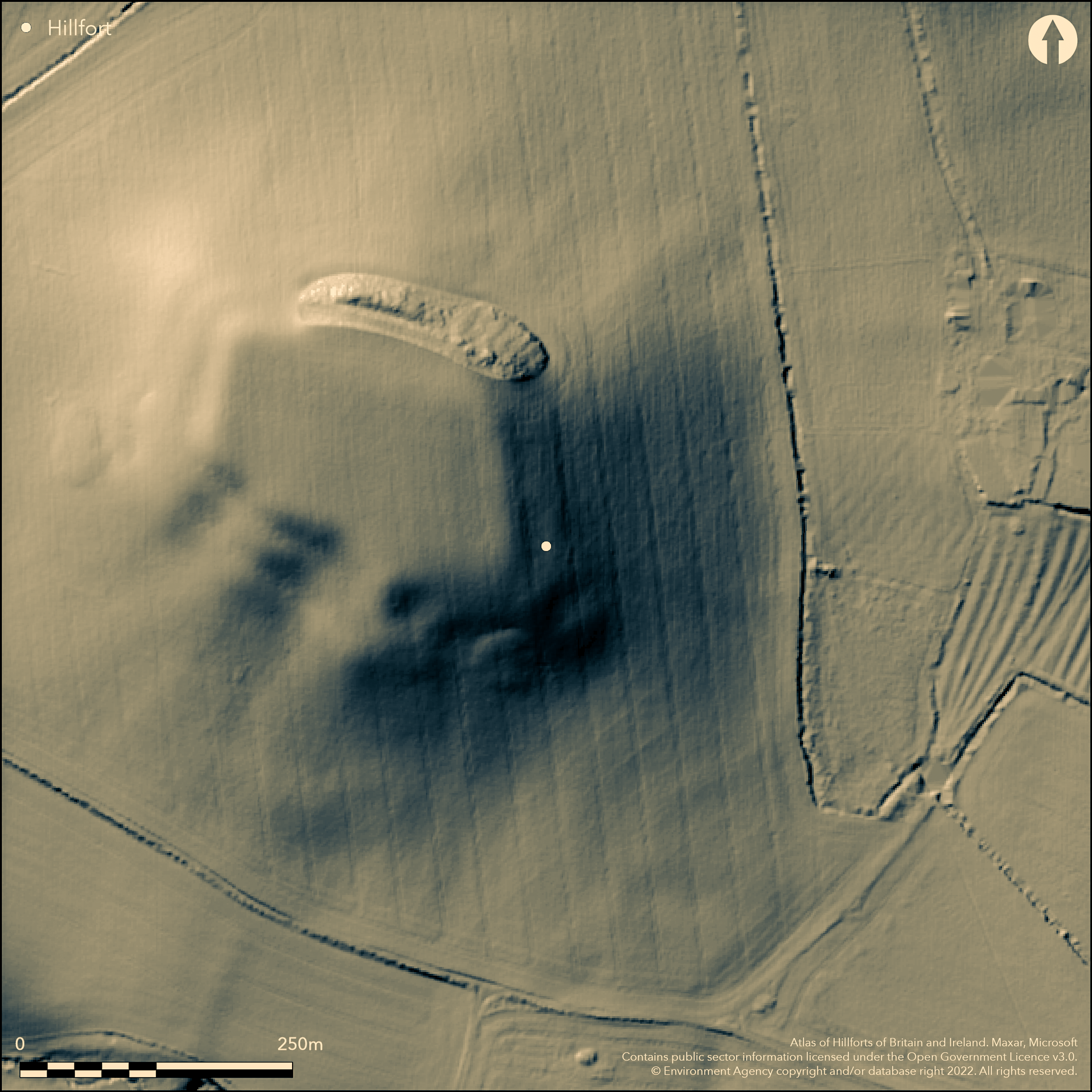
LiDAR 1m DTM Hillshade
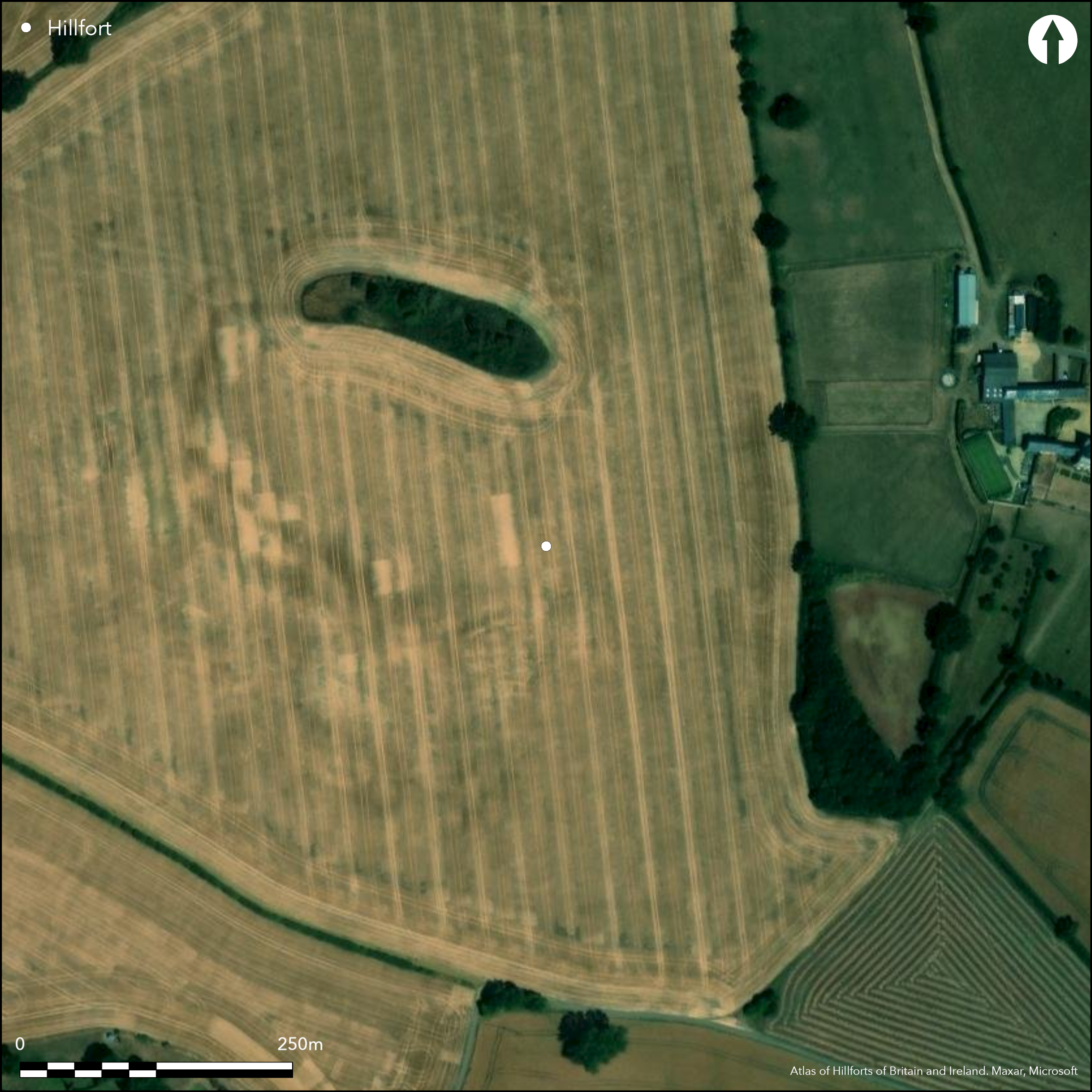
Satellite Imagery
LiDAR 1m DTM Hillshade
Satellite Imagery
Scroll left/right to view further images.
HER: Oxfordshire 1592 (MOX24)
NMR: SP 33 NE 4 (335052)
SM: 1006371
NGR: SP 3864 3889
X: 438750 Y: 238850 (OSGB36)
Four miles SW of Banbury, following the contours around a flat-topped hill with good views all around, an irregular oval shaped enclosing c.2.8ha. On the 1st Ed. OS map. The site has been severely ploughed and only a small fragment of rampart survives to the N. Univallate with a counterscarp bank to the N and E, possibly two banks and ditches plus a counterscarp bank to the S and W. No surface evidence for internal features, pits and material culture shown by excavation (Fowler 1960) of interior, ramparts and entrance. Pre-rampart palisaded enclosure (possibly early Iron Age), ramparts possible middle/late Iron Age, Romano-British re-use (3rd-4th centuries AD). Iron age open settlement downslope from hillfort.
Citizen Science: ✓
Reliability of Data: Confirmed
Reliability of Interpretation: Confirmed
X: -159898 Y: 6808566 (EPSG: 3857)
Longitude: -1.4363883787156344 Latitude: 52.046655806024866 (EPSG:4326)
Country: England
Current County or Unitary Authority: Oxfordshire
Historic County: Oxfordshire
Current Parish/Community/Council/Townland: Swalcliffe
None
| Extant | ✓ |
| Cropmark | ✗ |
| Likely Destroyed | ✗ |
Shown as upstanding multivallate on aerial photos of 1947, has since been flattened by ploughing except for small section of rampart under scrub on NE side.
| Woodland | ✗ |
| Commercial Forestry Plantation | ✗ |
| Parkland | ✗ |
| Pasture (Grazing) | ✗ |
| Arable | ✓ |
| Scrub/Bracken | ✓ |
| Bare Outcrop | ✗ |
| Heather/Moorland | ✗ |
| Heath | ✗ |
| Built-up | ✗ |
| Coastal Grassland | ✗ |
| Other | ✗ |
Follows the contours of an isolated hill
| Contour Fort | ✓ |
| Partial Contour Fort | ✗ |
| Promontory Fort | ✗ |
| Hillslope Fort | ✗ |
| Level Terrain Fort | ✗ |
| Marsh Fort | ✗ |
| Multiple Enclosure Fort | ✗ |
Follows the contours of an isolated hill
| Hilltop | ✓ |
| Coastal Promontory | ✗ |
| Inland Promontory | ✗ |
| Valley Bottom | ✗ |
| Knoll/Hillock/Outcrop | ✗ |
| Ridge | ✗ |
| Cliff/Plateau-edge/Scarp | ✗ |
| Hillslope | ✗ |
| Lowland | ✗ |
| Spur | ✗ |
Dominant Topographic Feature: On a prominent flat-topped hill, good views all around
| North | ✗ |
| Northeast | ✗ |
| East | ✗ |
| Southeast | ✗ |
| South | ✗ |
| Southwest | ✗ |
| West | ✗ |
| Northwest | ✗ |
| Level | ✓ |
Altitude: 171.0m
N/A
Initial palisaded enclosure probably early Iron Age, ramparts probably middle/late Iron Age, Romano-British re-use, pottery mainly 3rd-4th centuries AD.
Reliability: B - Medium
| Pre 1200BC | ✗ |
| 1200BC - 800BC | ✗ |
| 800BC - 400BC | ✓ |
| 400BC - AD50 | ✓ |
| AD50 - AD400 | ✓ |
| AD400 - AD 800 | ✗ |
| Post AD800 | ✗ |
| Unknown | ✗ |
| Pre Hillfort: | None |
| Post Hillfort: | None |
| Artefactual: | Pottery |
On 1st Edition OS map (1885-1890), in Plot 1705. Excavations by Oxford University Archaeological Society (P.J. Fowler) 1957-8, including geophysical survey, Fowler 1960. Ramparts, entrance and interior. 1978 - field walking by Sibford Gower Primary School.
| 1st Identified Written Reference (1705): | Plot |
| Other (1978): | field walking |
| 1st Identified Map Depiction (None): | 1st Ed OS |
| Excavation (None): | Fowler 1960. |
| Geophysical Survey (None): | Fowler 1960. |
Pits from excavation and geophysics, pottery and iron finds
Pond just outside SW rampart, shown on plan but now dry, stream c.400m away
| None | ✓ |
| Spring | ✗ |
| Stream | ✗ |
| Pool | ✗ |
| Flush | ✗ |
| Well | ✗ |
| Other | ✗ |
None
| No Known Features | ✓ |
| Round Stone Structures | ✗ |
| Rectangular Stone Structures | ✗ |
| Curvilinear Platforms | ✗ |
| Other Roundhouse Evidence | ✗ |
| Pits | ✗ |
| Quarry Hollows | ✗ |
| Other | ✗ |
Pits and postholes from excavation
| No Known Excavation | ✗ |
| Pits | ✓ |
| Postholes | ✓ |
| Roundhouses | ✗ |
| Rectangular Structures | ✗ |
| Roads/Tracks | ✗ |
| Quarry Hollows | ✗ |
| Other | ✗ |
| Nothing Found | ✗ |
Pits from geophysics
| No Known Geophysics | ✗ |
| Pits | ✓ |
| Roundhouses | ✗ |
| Rectangular Structures | ✗ |
| Roads/Tracks | ✗ |
| Quarry Hollows | ✗ |
| Other | ✗ |
| Nothing Found | ✗ |
Finds from excavation, pottery and iron including currency bar hoard
| No Known Finds | ✗ |
| Pottery | ✓ |
| Metal | ✓ |
| Metalworking | ✗ |
| Human Bones | ✗ |
| Animal Bones | ✓ |
| Lithics | ✗ |
| Environmental | ✗ |
| Other | ✗ |
None
| APs Not Checked | ✗ |
| None | ✓ |
| Roundhouses | ✗ |
| Rectangular Structures | ✗ |
| Pits | ✗ |
| Postholes | ✗ |
| Roads/Tracks | ✗ |
| Other | ✗ |
Appears to be an original entrance to the S, an oblique break through the inner rampart with an outwork bank running E-W
| 1: | None |
| 2: | None |
Guard Chambers: ✗
Chevaux de Frise: ✗
| 1. Outworks (South): | None |
| 1. Oblique (South): | None |
Univallate with a ditch and counterscarp bank to N and E, to S and W bivallate with two ditches and a counterscarp bank. Ploughed out except for small length NE
| Area 1: | 2.8ha. |
| Total: | 2.8ha. |
Total Footprint Area: Noneha.
Univallate with a ditch and counterscarp bank to N and E, to S and W bivallate with two ditches and a counterscarp bank.
| ✗ | None |
| ✓ | None |
| NE Quadrant: | 1 |
| SE Quadrant: | 2 |
| SW Quadrant: | 2 |
| NW Quadrant: | 1 |
| Total: | 2 |
| Partial Univallate | ✓ |
| Univallate | ✗ |
| Partial Bivallate | ✓ |
| Bivallate | ✗ |
| Partial Multivallate | ✗ |
| Multivallate | ✗ |
| Unknown | ✗ |
| Partial Univallate | ✗ |
| Univallate | ✗ |
| Partial Bivallate | ✗ |
| Bivallate | ✗ |
| Partial Multivallate | ✗ |
| Multivallate | ✗ |
Earthen bank with counterscarp bank
| None | ✗ |
| Earthen Bank | ✓ |
| Stone Wall | ✗ |
| Rubble | ✗ |
| Wall-walk | ✗ |
| Evidence of Timber | ✗ |
| Vitrification | ✗ |
| Other Burning | ✗ |
| Palisade | ✗ |
| Counter Scarp Bank | ✓ |
| Berm | ✗ |
| Unfinished | ✗ |
| Other | ✗ |
Rampart and counterscarp bank of piles clay
| None | ✗ |
| Earthen Bank | ✓ |
| Stone Wall | ✗ |
| Murus Duplex | ✗ |
| Timber-framed | ✗ |
| Timber-laced | ✗ |
| Vitrification | ✗ |
| Other Burning | ✗ |
| Palisade | ✗ |
| Counter Scarp Bank | ✓ |
| Berm | ✗ |
| Unfinished | ✗ |
| No Known Excavation | ✗ |
| Other | ✗ |
| ✗ | None |
| ✓ | One ditch to N and E, two to S and W |
Number of Ditches: 2
| ✗ | None |
Fowler, P.J. 1960. Excavations at Madmarston Camp, Swalcliffe, 1957-8. Oxoniensia, 25, 3-48.
Manning, P. and Leeds, E.T. 1921. An archaeological survey of Oxfordshire. London: Society of Antiquaries.
Page, W. (ed) 1907. The Victoria History of the County of Oxford, Vol II. London, 311.
Plot, R. 1705. The natural history of Oxfordshire, 341.
Atlas of Hillforts:
Wikidata:
This work is licensed under CC BY-SA 4.0![]()
![]()
![]() and should be cited as:
and should be cited as:
Lock, Gary and Ralston, Ian. 2024. Atlas of Hillforts of Britain and Ireland. Available at: https://hillforts.arch.ox.ac.uk
Document Version 1.1