LiDAR 1m DTM Hillshade
Satellite Imagery
LiDAR 1m DTM Hillshade
Satellite Imagery
Scroll left/right to view further images.
HER: Oxfordshire 7609 (MOX156)
NMR: SU 58 NW 1 (237555)
SM: 1006301
NGR: SU 5467 8617
X: 454750 Y: 186250 (OSGB36)
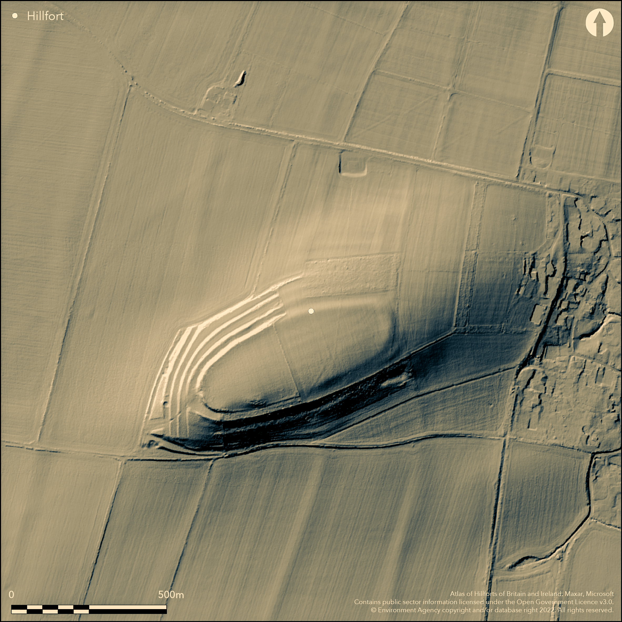
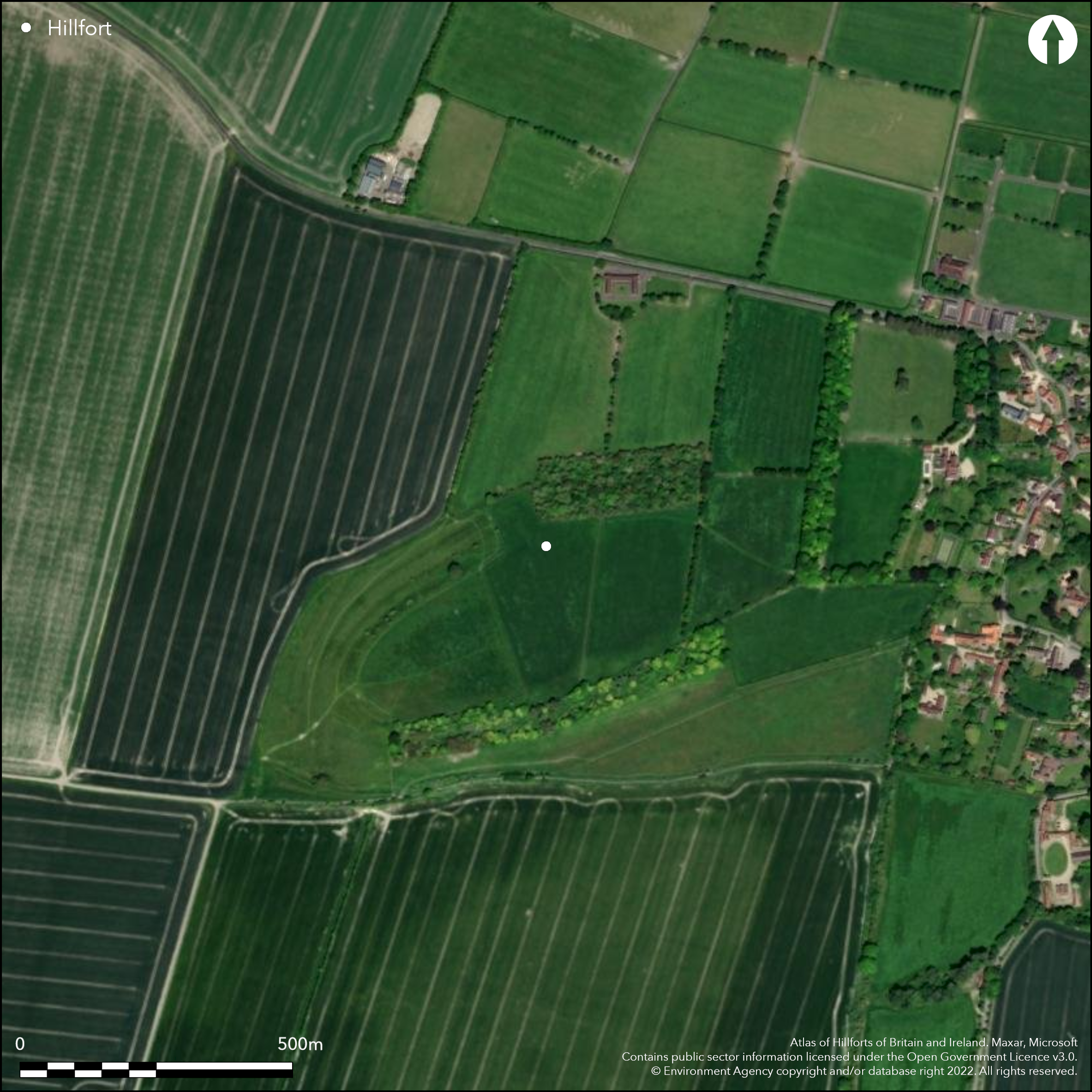
Between Blewbury and Aston Tirrold, a contour fort on a prominent isolated hill enclosing c.4.1ha. On 1st Ed. OS map (1885-1890). Probably originally univallate with a counterscarp bank for the entire circuit although now only traceable for the western half On the western slopes are a series of lynchets which are probably post-Iron Age, the rampart only survives as a negative lynchet around the top break of slope. Excavations (Collins 1947; 1952; Collins and Collins 1959; Harding 1976) have shown internal features and produced a three-phase interpretation of the ramparts:stockaded camp (7th-6th centuries BC); box rampart (6th-5th centuries BC); dump rampart (2nd-1st centuries BC), abandoned by the end of the 1st century BC. Original entrance at the W, reveted passage way and gateposts with horse burials. Limited Romano-British re-use, an Anglo-Saxon inhumation cemetery within the enclosure in the W.
Citizen Science: ✗
Reliability of Data: Confirmed
Reliability of Interpretation: Confirmed
X: -134852 Y: 6723179 (EPSG: 3857)
Longitude: -1.2113996986424165 Latitude: 51.572418703737235 (EPSG:4326)
Country: England; None
Current County or Unitary Authority: Oxfordshire
Historic County: Berkshire
Current Parish/Community/Council/Townland: Aston Upthorpe; Blewbury
None
| Extant | ✓ |
| Cropmark | ✗ |
| Likely Destroyed | ✗ |
Ramparts survive around north-western and south-western quadrants as lynchets on the top of the slope. Complicated to north and west by (later) field terraces. Eastern side of site ploughed down, some tree cover on south and north-east.
| Woodland | ✓ |
| Commercial Forestry Plantation | ✗ |
| Parkland | ✗ |
| Pasture (Grazing) | ✓ |
| Arable | ✗ |
| Scrub/Bracken | ✗ |
| Bare Outcrop | ✗ |
| Heather/Moorland | ✗ |
| Heath | ✗ |
| Built-up | ✗ |
| Coastal Grassland | ✗ |
| Other | ✗ |
Follows the contours of an isolated hill
| Contour Fort | ✓ |
| Partial Contour Fort | ✗ |
| Promontory Fort | ✗ |
| Hillslope Fort | ✗ |
| Level Terrain Fort | ✗ |
| Marsh Fort | ✗ |
| Multiple Enclosure Fort | ✗ |
Follows the contours of an isolated hill
| Hilltop | ✓ |
| Coastal Promontory | ✗ |
| Inland Promontory | ✗ |
| Valley Bottom | ✗ |
| Knoll/Hillock/Outcrop | ✗ |
| Ridge | ✗ |
| Cliff/Plateau-edge/Scarp | ✗ |
| Hillslope | ✗ |
| Lowland | ✗ |
| Spur | ✗ |
Dominant Topographic Feature: Isolated hill with good views all around
| North | ✗ |
| Northeast | ✗ |
| East | ✗ |
| Southeast | ✗ |
| South | ✗ |
| Southwest | ✗ |
| West | ✗ |
| Northwest | ✗ |
| Level | ✓ |
Altitude: 110.0m
Boundary Type: Parish/Townland
Three phases: stockaded camp (7th-6th centuries BC); box rampart (6th-5th centuries BC); dump rampart (2nd-1st centuries BC). Abandoned by the end of the 1st century BC.
Reliability: A - High
| Pre 1200BC | ✗ |
| 1200BC - 800BC | ✗ |
| 800BC - 400BC | ✓ |
| 400BC - AD50 | ✓ |
| AD50 - AD400 | ✗ |
| AD400 - AD 800 | ✗ |
| Post AD800 | ✗ |
| Unknown | ✗ |
| Pre Hillfort: | None |
| Post Hillfort: | None |
| Artefactual: | Pottery |
On 1st Ed. OS map (1885-1890). Excavations by A.E.P. and F.J. Collins between 1947 and 1953 (9 trenches in the western end, interior, entrance and ramparts). Re-excavation by D.W. Harding in 1967 (western end, entrance interior and ramparts).
| Excavation (1967): | see Harding 1976 |
| 1st Identified Map Depiction (None): | 1st Ed. OS |
| Excavation (None): | see Collins 1947; 1952; Collins and Collins 1959. |
Postholes, pits, round houses with a good suite of pottery and other material culture from excavations
None
| None | ✓ |
| Spring | ✗ |
| Stream | ✗ |
| Pool | ✗ |
| Flush | ✗ |
| Well | ✗ |
| Other | ✗ |
None
| No Known Features | ✓ |
| Round Stone Structures | ✗ |
| Rectangular Stone Structures | ✗ |
| Curvilinear Platforms | ✗ |
| Other Roundhouse Evidence | ✗ |
| Pits | ✗ |
| Quarry Hollows | ✗ |
| Other | ✗ |
None
| No Known Excavation | ✗ |
| Pits | ✓ |
| Postholes | ✓ |
| Roundhouses | ✓ |
| Rectangular Structures | ✗ |
| Roads/Tracks | ✓ |
| Quarry Hollows | ✗ |
| Other | ✓ |
| Nothing Found | ✗ |
None
| No Known Geophysics | ✓ |
| Pits | ✗ |
| Roundhouses | ✗ |
| Rectangular Structures | ✗ |
| Roads/Tracks | ✗ |
| Quarry Hollows | ✗ |
| Other | ✗ |
| Nothing Found | ✗ |
None
| No Known Finds | ✗ |
| Pottery | ✓ |
| Metal | ✓ |
| Metalworking | ✗ |
| Human Bones | ✓ |
| Animal Bones | ✓ |
| Lithics | ✗ |
| Environmental | ✗ |
| Other | ✗ |
None
| APs Not Checked | ✗ |
| None | ✓ |
| Roundhouses | ✗ |
| Rectangular Structures | ✗ |
| Pits | ✗ |
| Postholes | ✗ |
| Roads/Tracks | ✗ |
| Other | ✗ |
Western entrance (excavated), three phases, cobbled surface, timber passageway replaced by stone-lined passage in late phase. Unusual horse burials in the inner passage way.
| None: | Unknown, heavy tree cover over W half of site |
| 2: | Western entrance (excavated), three phases, cobbled surface, timber passageway replaced by stone-lined passage in late phase. Unusual horse burials in the inner passage way. |
Guard Chambers: ✗
Chevaux de Frise: ✗
| 1. Passage-way/Corridor (West): | Corridor entrance at W excavated |
Probably univallate with ditch and counterscarp bank. Little remains of the rampart, mainly as a negative lynchet around the W half, ploughed away in E half, ditches survive as flat terrace in the W. Series of post-Iron Age lynchets down-slope in the W.
| Area 1: | 4.1ha. |
| Total: | 4.1ha. |
Total Footprint Area: Noneha.
Probably univallate with ditch and counterscarp bank. Little remains of the rampart, mainly as a negative lynchet around the W half, ploughed away in E half, ditches survive as flat terrace in the W. Series of post-Iron Age lynchets down-slope in the W.
| ✗ | None |
| ✓ | From aerial photographs |
| NE Quadrant: | 1 |
| SE Quadrant: | 1 |
| SW Quadrant: | 1 |
| NW Quadrant: | 1 |
| Total: | 1 |
| Partial Univallate | ✗ |
| Univallate | ✓ |
| Partial Bivallate | ✗ |
| Bivallate | ✗ |
| Partial Multivallate | ✗ |
| Multivallate | ✗ |
| Unknown | ✗ |
| Partial Univallate | ✗ |
| Univallate | ✗ |
| Partial Bivallate | ✗ |
| Bivallate | ✗ |
| Partial Multivallate | ✗ |
| Multivallate | ✗ |
None
| None | ✗ |
| Earthen Bank | ✓ |
| Stone Wall | ✗ |
| Rubble | ✗ |
| Wall-walk | ✗ |
| Evidence of Timber | ✗ |
| Vitrification | ✗ |
| Other Burning | ✗ |
| Palisade | ✗ |
| Counter Scarp Bank | ✓ |
| Berm | ✗ |
| Unfinished | ✗ |
| Other | ✗ |
None
| None | ✗ |
| Earthen Bank | ✓ |
| Stone Wall | ✗ |
| Murus Duplex | ✗ |
| Timber-framed | ✓ |
| Timber-laced | ✓ |
| Vitrification | ✗ |
| Other Burning | ✗ |
| Palisade | ✗ |
| Counter Scarp Bank | ✓ |
| Berm | ✓ |
| Unfinished | ✗ |
| No Known Excavation | ✗ |
| Other | ✗ |
| ✗ | None |
| ✗ | Excavation shows main ditch to be c.2m wide, c.2m deep and flat-bottomed |
Number of Ditches: 1
| ✗ | None |
Collins, A.E.P. 1947, Excavations on Blewburton Hill, 1947. Berkshire Archaeol J, 50, 4-29.
Collins, A.E.P. 1952, Excavations on Blewburton Hill, 1948-9. Berkshire Archaeol J, 53, 21-64.
Collins, A.E.P. and Collins, F.J. 1959, Excavations on Blewburton Hill, Berks, 1953. Berkshire Archaeol J, 57, 52-73.
Harding, D.W. 1976. Blewburton Hill, Berkshire: Re-excavation and reappraisal, in Harding, D.W. (ed) Hillforts. Later prehistoric earthworks in Britain and Ireland. London: Academic Press, 133-146.
Atlas of Hillforts:
Wikidata:
This work is licensed under CC BY-SA 4.0![]()
![]()
![]() and should be cited as:
and should be cited as:
Lock, Gary and Ralston, Ian. 2024. Atlas of Hillforts of Britain and Ireland. Available at: https://hillforts.arch.ox.ac.uk
Document Version 1.1