LiDAR 1m DTM Hillshade
Satellite Imagery
LiDAR 1m DTM Hillshade
Satellite Imagery
Scroll left/right to view further images.
HER: Oxfordshire 4943 (MOX183)
NMR: SU 39 NE 4 (229424)
SM: 1006296
NGR: SU 3742 9620
X: 437450 Y: 196350 (OSGB36)
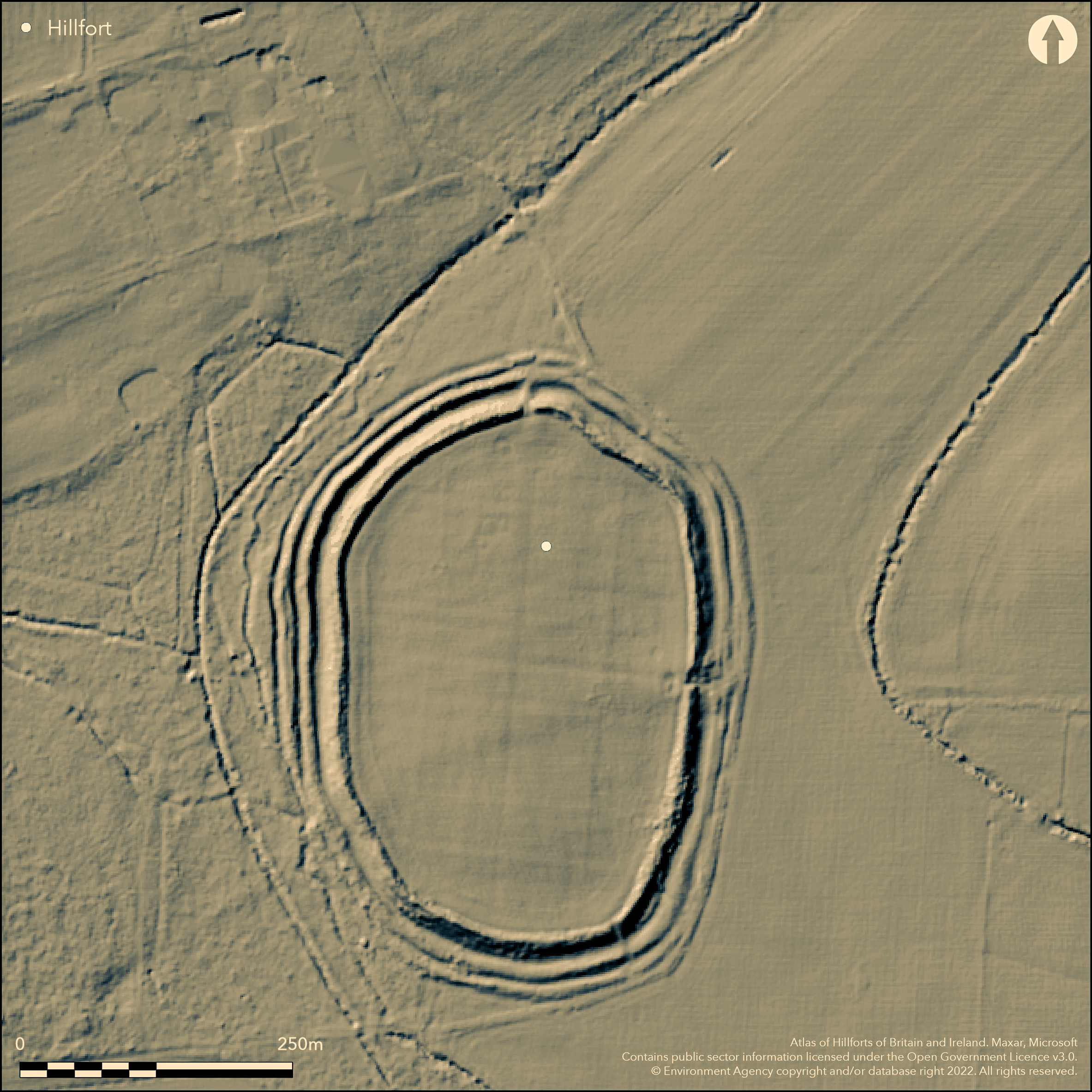
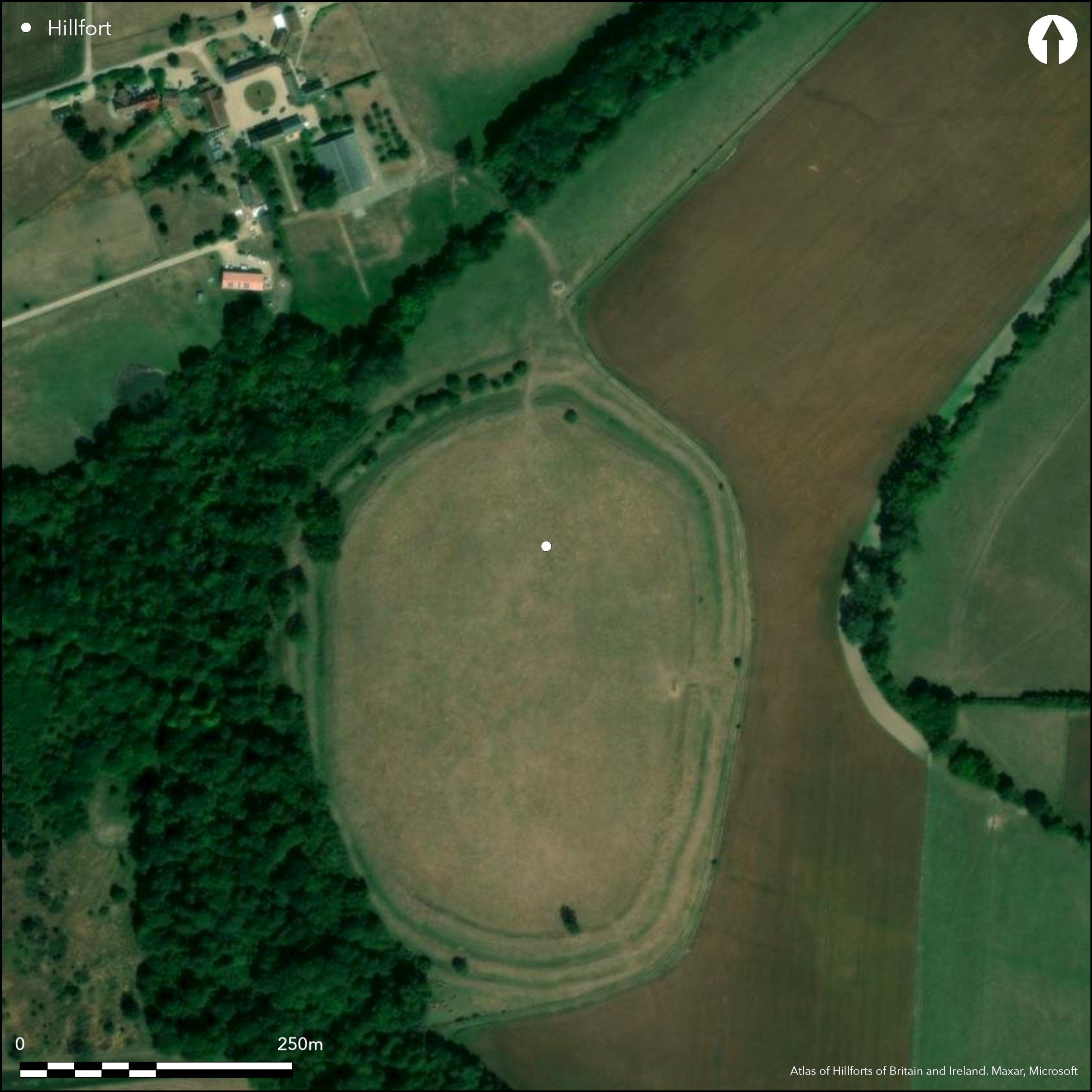
North of Charney Bassett, low-lying on a raised dry tongue of land within a wet and marshy area (as shown by Arkell 1939) with good views to the Ridgeway to the S. On 1st Ed. OS map (1885-1900). A regular oval-shaped site enclosing 4.6ha with three ramparts and two ditches between for the whole circuit although the outer rampart is probably a counterscarp bank. The outer rampart and counterscarp are are virtually gone on the E. Original entrance to E shown by excavation (Bradford 1940) to be a in-turned passageway with dry-stone wall revetting which continues along the outer face of the inner rampart, a cobbled roadway runs through the entrance. No excavation of the interior but aerial photography and geophysics (Wintle et. al. 2009) shows roundhouses and pits. Pottery from the excavation and subsequent surface collection (Hingley 1983) is dated to early and middle Iron Age. Possible small-scale Romano-British re-use.
Citizen Science: ✗
Reliability of Data: Confirmed
Reliability of Interpretation: Confirmed
X: -162519 Y: 6739714 (EPSG: 3857)
Longitude: -1.4599374381060186 Latitude: 51.66464024726273 (EPSG:4326)
Country: England
Current County or Unitary Authority: Oxfordshire
Historic County: Berkshire
Current Parish/Community/Council/Townland: Charney Bassett
None
| Extant | ✓ |
| Cropmark | ✗ |
| Likely Destroyed | ✗ |
Upstanding ramparts for the whole circuit although outer ramparts on the E side have gone, has been ploughed in the interior but now pasture, woodland along the W ramparts, patches of scrub in other areas, rampart damage due to animals
| Woodland | ✓ |
| Commercial Forestry Plantation | ✗ |
| Parkland | ✗ |
| Pasture (Grazing) | ✓ |
| Arable | ✗ |
| Scrub/Bracken | ✓ |
| Bare Outcrop | ✗ |
| Heather/Moorland | ✗ |
| Heath | ✗ |
| Built-up | ✗ |
| Coastal Grassland | ✗ |
| Other | ✗ |
Flat, low-lying within wet/marshy area (Arkell 1939)
| Contour Fort | ✗ |
| Partial Contour Fort | ✗ |
| Promontory Fort | ✗ |
| Hillslope Fort | ✗ |
| Level Terrain Fort | ✗ |
| Marsh Fort | ✓ |
| Multiple Enclosure Fort | ✗ |
Flat, low-lying within wet/marshy area (Arkell 1939)
| Hilltop | ✗ |
| Coastal Promontory | ✗ |
| Inland Promontory | ✗ |
| Valley Bottom | ✓ |
| Knoll/Hillock/Outcrop | ✗ |
| Ridge | ✗ |
| Cliff/Plateau-edge/Scarp | ✗ |
| Hillslope | ✗ |
| Lowland | ✗ |
| Spur | ✗ |
Dominant Topographic Feature: On dry tongue of land within wet/marshy area
| North | ✗ |
| Northeast | ✗ |
| East | ✗ |
| Southeast | ✗ |
| South | ✗ |
| Southwest | ✗ |
| West | ✗ |
| Northwest | ✗ |
| Level | ✓ |
Altitude: 72.0m
N/A
Early and middle Iron Age pottery from excavation and surface finds
Reliability: B - Medium
| Pre 1200BC | ✗ |
| 1200BC - 800BC | ✗ |
| 800BC - 400BC | ✓ |
| 400BC - AD50 | ✓ |
| AD50 - AD400 | ✗ |
| AD400 - AD 800 | ✗ |
| Post AD800 | ✗ |
| Unknown | ✗ |
| Pre Hillfort: | None |
| Post Hillfort: | None |
| Artefactual: | pottery |
On 1st Ed. OS map (1885-1900). Excavations in 1939 (Bradford 1940), rampart and E entrance. Surface finds (Hingley 1983). RCHME/EH survey, ref. no. 917381. Geophysical survey of interior and nearby cropmarks (Wintle et. al. 2009).
| Excavation (1939): | Bradford 1940 |
| Other (1939): | Environmental sampling, Arkell 1939. |
| Other (1983): | Surface survey, Hingley 1983. |
| Other (2003): | Visited by Hillfort Study Group |
| Geophysical Survey (2007): | Wintle et. al. 2009 |
| 1st Identified Map Depiction (None): | 1st Ed. OS |
| Earthwork Survey (None): | None |
No surface evidence, roundhouses and pits shown by geophysics, early and middle Iron Age pottery by excavation and surface survey
No obvious source inside but surrounded by wet marshland with many streams
| None | ✓ |
| Spring | ✗ |
| Stream | ✗ |
| Pool | ✗ |
| Flush | ✗ |
| Well | ✗ |
| Other | ✗ |
No surface features due to heavy ploughing of interior
| No Known Features | ✓ |
| Round Stone Structures | ✗ |
| Rectangular Stone Structures | ✗ |
| Curvilinear Platforms | ✗ |
| Other Roundhouse Evidence | ✗ |
| Pits | ✗ |
| Quarry Hollows | ✗ |
| Other | ✗ |
No excavation within the interior
| No Known Excavation | ✓ |
| Pits | ✗ |
| Postholes | ✗ |
| Roundhouses | ✗ |
| Rectangular Structures | ✗ |
| Roads/Tracks | ✗ |
| Quarry Hollows | ✗ |
| Other | ✗ |
| Nothing Found | ✗ |
Roundhouses, pits and a possible roadway shown by geophysics
| No Known Geophysics | ✗ |
| Pits | ✓ |
| Roundhouses | ✓ |
| Rectangular Structures | ✗ |
| Roads/Tracks | ✓ |
| Quarry Hollows | ✗ |
| Other | ✗ |
| Nothing Found | ✗ |
Pottery from excavation and field walking
| No Known Finds | ✗ |
| Pottery | ✓ |
| Metal | ✗ |
| Metalworking | ✗ |
| Human Bones | ✗ |
| Animal Bones | ✗ |
| Lithics | ✗ |
| Environmental | ✗ |
| Other | ✗ |
None
| APs Not Checked | ✓ |
| None | ✗ |
| Roundhouses | ✗ |
| Rectangular Structures | ✗ |
| Pits | ✗ |
| Postholes | ✗ |
| Roads/Tracks | ✗ |
| Other | ✗ |
Original E entrance excavated (Bradford 1940), passageway slightly inturned, dry-stone revetted, cobbled surface. Breaks to N and SE are modern.
| 3: | Breaks to N and SE are modern. |
| 2: | None |
Guard Chambers: ✗
Chevaux de Frise: ✗
| 1. Passage-way/Corridor (East): | Passageway and slightly inturned entrance at E, excavation shows dry-stone wall revetting and laid road |
Three ramparts and two ditches between, outer may be a counterscarp bank. Outer two ramparts destroyed on E side. Stone walling eroding from inner rampart confirmed as dry stone revetting outer wall by excavation (Bradford 1940).
| Area 1: | 4.6ha. |
| Total: | 4.6ha. |
Total Footprint Area: Noneha.
Three ramparts and two ditches between, outer may be a counterscarp bank. Outer two ramparts destroyed on E side. Stone walling eroding from inner rampart confirmed as dry stone revetting outer wall by excavation (Bradford 1940).
| ✗ | None |
| ✓ | None |
| NE Quadrant: | 2 |
| SE Quadrant: | 2 |
| SW Quadrant: | 2 |
| NW Quadrant: | 2 |
| Total: | 2 |
| Partial Univallate | ✗ |
| Univallate | ✗ |
| Partial Bivallate | ✗ |
| Bivallate | ✓ |
| Partial Multivallate | ✗ |
| Multivallate | ✗ |
| Unknown | ✗ |
| Partial Univallate | ✗ |
| Univallate | ✗ |
| Partial Bivallate | ✗ |
| Bivallate | ✗ |
| Partial Multivallate | ✗ |
| Multivallate | ✗ |
Inner rampart shows eroding dry stone walling outer face and loose stone
| None | ✗ |
| Earthen Bank | ✓ |
| Stone Wall | ✓ |
| Rubble | ✓ |
| Wall-walk | ✗ |
| Evidence of Timber | ✗ |
| Vitrification | ✗ |
| Other Burning | ✗ |
| Palisade | ✗ |
| Counter Scarp Bank | ✓ |
| Berm | ✗ |
| Unfinished | ✗ |
| Other | ✗ |
Excavation showed dry stone outer revetting walling for inner rampart
| None | ✗ |
| Earthen Bank | ✓ |
| Stone Wall | ✓ |
| Murus Duplex | ✗ |
| Timber-framed | ✗ |
| Timber-laced | ✗ |
| Vitrification | ✗ |
| Other Burning | ✗ |
| Palisade | ✗ |
| Counter Scarp Bank | ✓ |
| Berm | ✗ |
| Unfinished | ✗ |
| No Known Excavation | ✗ |
| Other | ✗ |
| ✓ | Straight joint in revetting dry stone wall of inner rampart suggests gang working (Bradford 1940) |
| ✓ | Two ditches for whole circuit between three ramparts |
Number of Ditches: 2
| ✗ | None |
Bradford, J. 1940. The excavation of Cherbury Camp, 1939. An interim report. Oxoniensia, 5, 13-20.
Arkell, W. 1939. The site of Cherbury Camp. Oxoniensia, 4, 196-7.
Hingley, R. 1983. Charney Bassett: Cherbury Camp. S Midlands Archaeol, 13, 123-5.
Wintle, W., Hawes, J and Boyer K. 2009. Geophysical survey at and near Cherbury Camp. S Midlands Archaeol, 39, 67-71.
Atlas of Hillforts:
Wikidata:
This work is licensed under CC BY-SA 4.0![]()
![]()
![]() and should be cited as:
and should be cited as:
Lock, Gary and Ralston, Ian. 2024. Atlas of Hillforts of Britain and Ireland. Available at: https://hillforts.arch.ox.ac.uk
Document Version 1.1