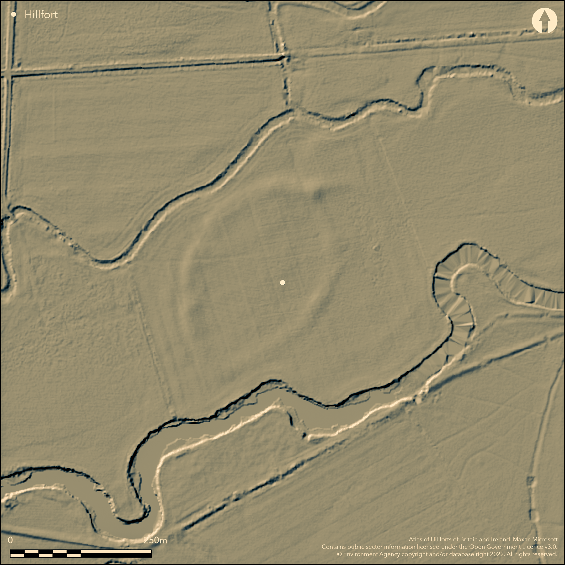
LiDAR 1m DTM Hillshade
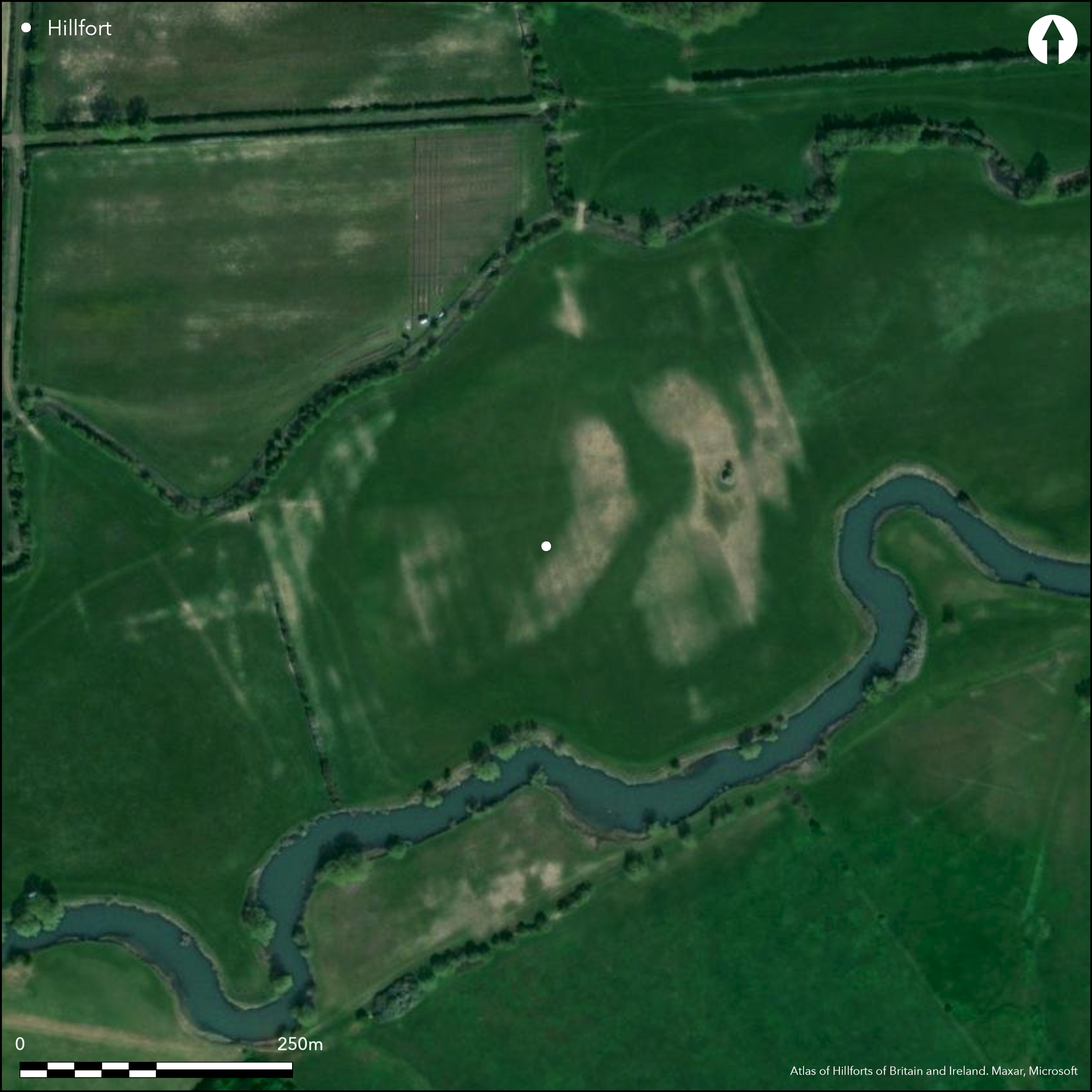
Satellite Imagery
LiDAR 1m DTM Hillshade
Satellite Imagery
Scroll left/right to view further images.
HER: Oxfordshire 2426 (MOX204)
NMR: SP 30 SW 14 (767712)
SM: 1013417
NGR: SP 3089 0037
X: 430885 Y: 200345 (OSGB36)
SE of Clanfield on a flat floodplain island between the River Thames and the Burroway Brook. A univallate roughly circular enclosure with a single ditch of 2ha internal area now only surviving as a low bank due to ploughing, identified from aerial photography. Two entrances, one to the NW with a possible outwork one to the NE which leads into a small rectangular annex with a further entrance on its NE side. Small scale excavations (Lambrick 1984; 2009) have shown the rampart to be timber-framed and to have been extensively burnt, internal features including roundhouses and pits are suggested by aerial photography. The site is poorly dated but pottery from the excavations suggests early and middle Iron Age.
Citizen Science: ✗
Reliability of Data: Confirmed
Reliability of Interpretation: Confirmed
X: -173046 Y: 6746234 (EPSG: 3857)
Longitude: -1.554502728739175 Latitude: 51.70095774904396 (EPSG:4326)
Country: England
Current County or Unitary Authority: Oxfordshire
Historic County: Oxfordshire
Current Parish/Community/Council/Townland: Clanfield
None
| Extant | ✓ |
| Cropmark | ✗ |
| Likely Destroyed | ✗ |
Rampart survives as a low bank, ditch visible on aerial photographs as are some internal features. Under arable cultivation and pasture.
| Woodland | ✗ |
| Commercial Forestry Plantation | ✗ |
| Parkland | ✗ |
| Pasture (Grazing) | ✗ |
| Arable | ✓ |
| Scrub/Bracken | ✗ |
| Bare Outcrop | ✗ |
| Heather/Moorland | ✗ |
| Heath | ✗ |
| Built-up | ✗ |
| Coastal Grassland | ✗ |
| Other | ✗ |
On the flat floodplain between the River Thames and the Burroway Brook, close to both.
| Contour Fort | ✗ |
| Partial Contour Fort | ✗ |
| Promontory Fort | ✗ |
| Hillslope Fort | ✗ |
| Level Terrain Fort | ✓ |
| Marsh Fort | ✗ |
| Multiple Enclosure Fort | ✗ |
On the flat floodplain between the River Thames and the Burroway Brook, close to both.
| Hilltop | ✗ |
| Coastal Promontory | ✗ |
| Inland Promontory | ✗ |
| Valley Bottom | ✓ |
| Knoll/Hillock/Outcrop | ✗ |
| Ridge | ✗ |
| Cliff/Plateau-edge/Scarp | ✗ |
| Hillslope | ✗ |
| Lowland | ✗ |
| Spur | ✗ |
Dominant Topographic Feature: Dominates the floodplain
| North | ✗ |
| Northeast | ✗ |
| East | ✗ |
| Southeast | ✗ |
| South | ✗ |
| Southwest | ✗ |
| West | ✗ |
| Northwest | ✗ |
| Level | ✓ |
Altitude: 68.0m
N/A
Small amounts of Iron Age pottery from excavations, possibly early and middle Iron Age.
Reliability: B - Medium
| Pre 1200BC | ✗ |
| 1200BC - 800BC | ✗ |
| 800BC - 400BC | ✓ |
| 400BC - AD50 | ✓ |
| AD50 - AD400 | ✗ |
| AD400 - AD 800 | ✗ |
| Post AD800 | ✗ |
| Unknown | ✗ |
| Pre Hillfort: | None |
| Post Hillfort: | None |
| Artefactual: | Small amounts of Iron Age pottery from excavations, possibly early and middle Iron Age. |
Known from aerial photographs. Small scale amateur excavations in 1962 (unpublished) across the ditch, small scale evaluation excavation in 1983 (Lambrick 1984) comprised two trenches, one in the interior and one across the bank (Lambrick 2009).
| Excavation (1962): | Clanfield Historical Society, unpublished |
| Excavation (1983): | Lambrick 1984 |
Aerial photography suggests roundhouses, pits and gullies. Excavation has shown a posthole.
On the floodplain of the River Thames and close to it.
| None | ✓ |
| Spring | ✗ |
| Stream | ✗ |
| Pool | ✗ |
| Flush | ✗ |
| Well | ✗ |
| Other | ✗ |
None
| No Known Features | ✓ |
| Round Stone Structures | ✗ |
| Rectangular Stone Structures | ✗ |
| Curvilinear Platforms | ✗ |
| Other Roundhouse Evidence | ✗ |
| Pits | ✗ |
| Quarry Hollows | ✗ |
| Other | ✗ |
Posthole
| No Known Excavation | ✗ |
| Pits | ✗ |
| Postholes | ✓ |
| Roundhouses | ✗ |
| Rectangular Structures | ✗ |
| Roads/Tracks | ✗ |
| Quarry Hollows | ✗ |
| Other | ✗ |
| Nothing Found | ✗ |
None
| No Known Geophysics | ✓ |
| Pits | ✗ |
| Roundhouses | ✗ |
| Rectangular Structures | ✗ |
| Roads/Tracks | ✗ |
| Quarry Hollows | ✗ |
| Other | ✗ |
| Nothing Found | ✗ |
Small amounts of pottery from excavations.
| No Known Finds | ✗ |
| Pottery | ✓ |
| Metal | ✗ |
| Metalworking | ✗ |
| Human Bones | ✗ |
| Animal Bones | ✗ |
| Lithics | ✗ |
| Environmental | ✗ |
| Other | ✗ |
Roundhouse and pits from aerial photography
| APs Not Checked | ✗ |
| None | ✗ |
| Roundhouses | ✓ |
| Rectangular Structures | ✗ |
| Pits | ✓ |
| Postholes | ✗ |
| Roads/Tracks | ✗ |
| Other | ✗ |
Two entrances, NE a simple gap into an annex, NW a simple gap with possible outwork, both known mainly from aerial photography
| 2: | None |
| 2: | None |
Guard Chambers: ✗
Chevaux de Frise: ✗
| 1. Simple Gap (North east): | simple gap via an annex |
| 2. Outworks (North west): | simple gap with possible outwork |
| 2. Simple Gap (North west): | None |
Univallate with ditch for entire circuit.
| Area 1: | 2.0ha. |
| Total: | 2.0ha. |
Total Footprint Area: Noneha.
None
| ✗ | None |
| ✓ | None |
| NE Quadrant: | 1 |
| SE Quadrant: | 1 |
| SW Quadrant: | 1 |
| NW Quadrant: | 1 |
| Total: | 1 |
| Partial Univallate | ✗ |
| Univallate | ✓ |
| Partial Bivallate | ✗ |
| Bivallate | ✗ |
| Partial Multivallate | ✗ |
| Multivallate | ✗ |
| Unknown | ✗ |
| Partial Univallate | ✗ |
| Univallate | ✗ |
| Partial Bivallate | ✗ |
| Bivallate | ✗ |
| Partial Multivallate | ✗ |
| Multivallate | ✗ |
Bank survives to c1m high in places, ploughed.
| None | ✗ |
| Earthen Bank | ✓ |
| Stone Wall | ✗ |
| Rubble | ✗ |
| Wall-walk | ✗ |
| Evidence of Timber | ✗ |
| Vitrification | ✗ |
| Other Burning | ✗ |
| Palisade | ✗ |
| Counter Scarp Bank | ✗ |
| Berm | ✗ |
| Unfinished | ✗ |
| Other | ✗ |
A single rampart which excavation has shownt to contain a timber frame constructed on a corduroy of timbers on the old ground surface, rampart material mainly clay. The whole structure was burnt.
| None | ✗ |
| Earthen Bank | ✓ |
| Stone Wall | ✗ |
| Murus Duplex | ✗ |
| Timber-framed | ✓ |
| Timber-laced | ✗ |
| Vitrification | ✗ |
| Other Burning | ✓ |
| Palisade | ✗ |
| Counter Scarp Bank | ✗ |
| Berm | ✗ |
| Unfinished | ✗ |
| No Known Excavation | ✗ |
| Other | ✗ |
| ✗ | None |
| ✓ | Single ditch shown to be c.5m wide, 2m deep flat bottomed by excavation (Lambrick 2009). |
Number of Ditches: 1
| ✓ | Small rectangular annex into which the NE entrance leads from the main enclosure, measures approx. 70m by 40m, simple gap entrance on the E to the outside. |
Sturdy, G. and Case, H.J. 1961-2. Archaeological notes. Oxoniensia, 26-7, 336-9.
Lambrick, G. 1984. Clanfield: Burroway. S Midlands Archaeol, 14, 104-5.
Lambrick, G. 2009. Thames Through Time. The archaeology of the gravel terraces of the upper and middle Thames. Late prehistory 1500 BC - AD 50. Oxford: Oxford Archaeology, Thames Valley Landscapes Monograph No. 29, 356-7.
Atlas of Hillforts:
Wikidata:
This work is licensed under CC BY-SA 4.0![]()
![]()
![]() and should be cited as:
and should be cited as:
Lock, Gary and Ralston, Ian. 2024. Atlas of Hillforts of Britain and Ireland. Available at: https://hillforts.arch.ox.ac.uk
Document Version 1.1