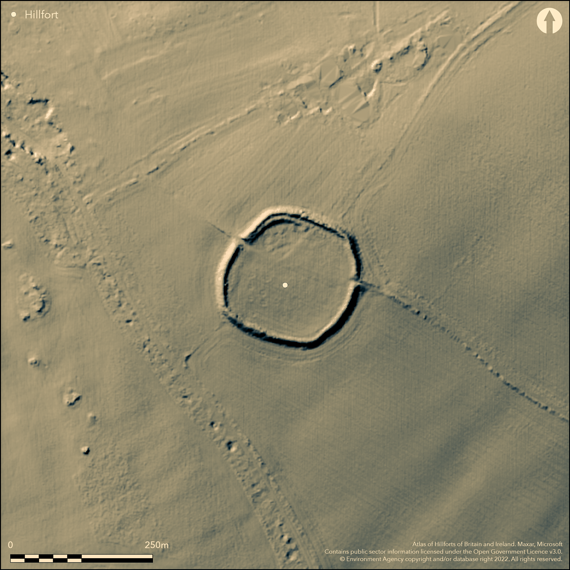
LiDAR 1m DTM Hillshade
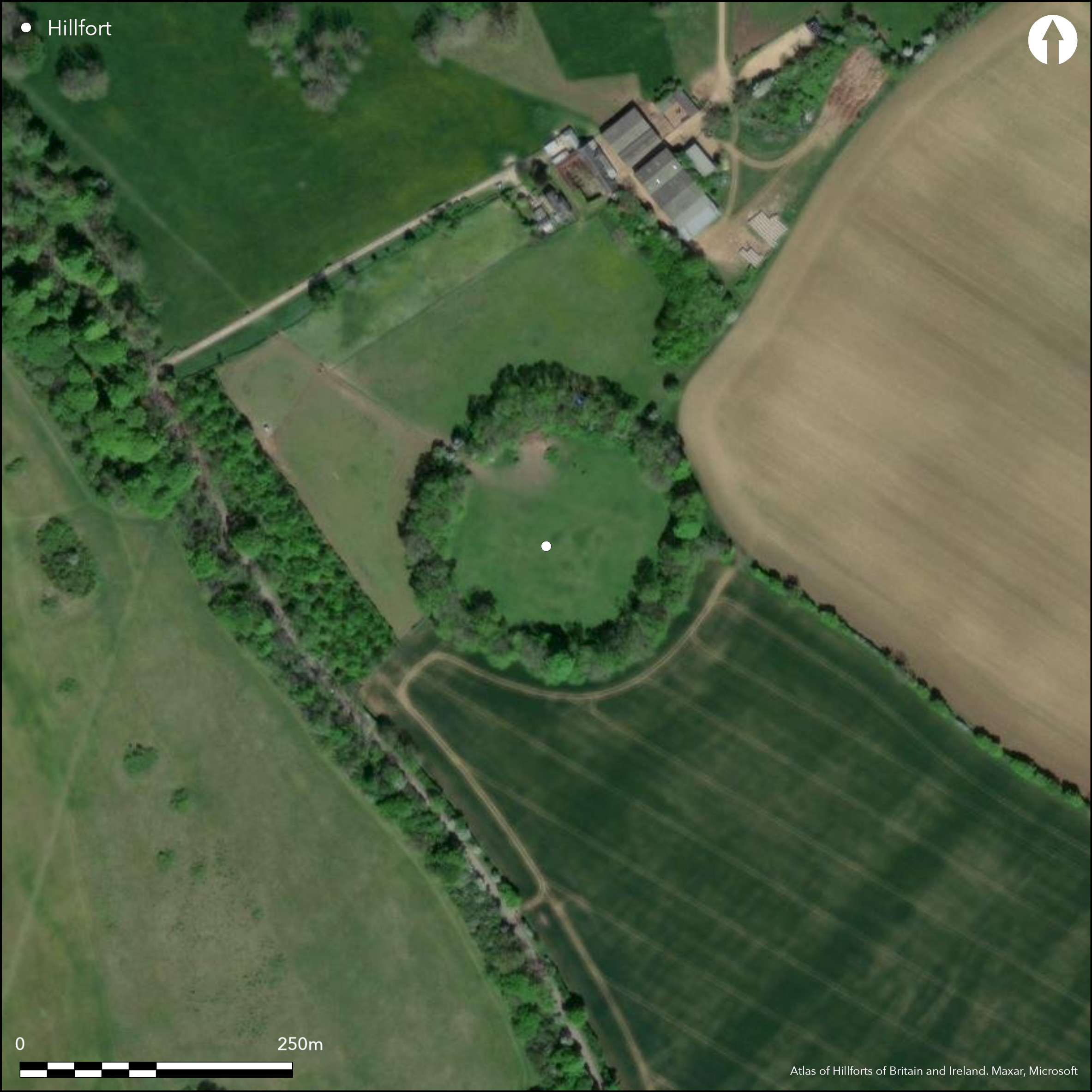
Satellite Imagery
LiDAR 1m DTM Hillshade
Satellite Imagery
Scroll left/right to view further images.
HER: Oxfordshire 1468 (MOX240)
NMR: SP 22 NE 4 (332469)
SM: 1008402
NGR: SP 2586 2823
X: 425848 Y: 228224 (OSGB36)
W of Chipping Norton, a circular enclosure located on a flat plateau with good views. On the 1st Ed. OS map (1885-1900). Univallate for the entire circuit enclosing c.1.4ha, two probably original entrances both simple gaps c. 3.5m wide at SE and NW. Small-scale excavations have shown the rampart to be faced with dry-stone walling and rubble filled, faces show eroding from the ramparts still which survive to c.4m high in places and are up to 14m wide. Possibly no ditch (Lang 2009) although suggestion of one on the E where it is 14m wide. The ramparts are suffering from tree damage, the interior has been ploughed. Limited excavation evidence and recent geophysical survey show occupation features in the interior. Pottery from the excavations (Price 1881; Leeds 1931; Sutton 1966) suggest it is early Iron Age.
Citizen Science: ✓
Reliability of Data: Confirmed
Reliability of Interpretation: Confirmed
X: -180929 Y: 6791428 (EPSG: 3857)
Longitude: -1.6253134371230122 Latitude: 51.951870337981674 (EPSG:4326)
Country: England
Current County or Unitary Authority: Oxfordshire
Historic County: Gloucestershire
Current Parish/Community/Council/Townland: Chastleton
None
| Extant | ✓ |
| Cropmark | ✗ |
| Likely Destroyed | ✗ |
Upstanding bank for complete circuit with stonework eroding, some signs of a filled in ditch. Rampart is tree covered, interior has been ploughed in the past as are the fields around the site, interior now pastur.
| Woodland | ✓ |
| Commercial Forestry Plantation | ✗ |
| Parkland | ✗ |
| Pasture (Grazing) | ✓ |
| Arable | ✓ |
| Scrub/Bracken | ✗ |
| Bare Outcrop | ✗ |
| Heather/Moorland | ✗ |
| Heath | ✗ |
| Built-up | ✗ |
| Coastal Grassland | ✗ |
| Other | ✗ |
A univallate fort on a raised level plateau.
| Contour Fort | ✗ |
| Partial Contour Fort | ✗ |
| Promontory Fort | ✗ |
| Hillslope Fort | ✗ |
| Level Terrain Fort | ✓ |
| Marsh Fort | ✗ |
| Multiple Enclosure Fort | ✗ |
| Hilltop | ✗ |
| Coastal Promontory | ✗ |
| Inland Promontory | ✗ |
| Valley Bottom | ✗ |
| Knoll/Hillock/Outcrop | ✗ |
| Ridge | ✗ |
| Cliff/Plateau-edge/Scarp | ✗ |
| Hillslope | ✗ |
| Lowland | ✓ |
| Spur | ✗ |
Dominant Topographic Feature: High point with good views of surrounding landscape
| North | ✗ |
| Northeast | ✗ |
| East | ✗ |
| Southeast | ✗ |
| South | ✗ |
| Southwest | ✗ |
| West | ✗ |
| Northwest | ✗ |
| Level | ✓ |
Altitude: 240.0m
N/A
Early Iron Age from excavations (Price 1881; Leeds 1931; Sutton 1966)
Reliability: B - Medium
| Pre 1200BC | ✗ |
| 1200BC - 800BC | ✗ |
| 800BC - 400BC | ✓ |
| 400BC - AD50 | ✗ |
| AD50 - AD400 | ✗ |
| AD400 - AD 800 | ✗ |
| Post AD800 | ✗ |
| Unknown | ✗ |
| Pre Hillfort: | None |
| Post Hillfort: | None |
| Artefactual: | Pottery from excavations |
On the 1st Ed. OS map (1885-1900). Excavations (Price 1881) a section across the rampart, (Leeds 1931), concentrated on the ramparts. Geophysical survey of the interior (Lang 2009).
| Excavation (1881): | Price 1881 |
| Geophysical Survey (2006): | Lang |
| 1st Identified Map Depiction (None): | 1st Ed. OS |
| Excavation (None): | Leeds 1932 |
No features show on the surface, minimal excavation has suggested occupation with cut features and hearths, geophysical survey mentions occupation features.
None
| None | ✓ |
| Spring | ✗ |
| Stream | ✗ |
| Pool | ✗ |
| Flush | ✗ |
| Well | ✗ |
| Other | ✗ |
None
| No Known Features | ✓ |
| Round Stone Structures | ✗ |
| Rectangular Stone Structures | ✗ |
| Curvilinear Platforms | ✗ |
| Other Roundhouse Evidence | ✗ |
| Pits | ✗ |
| Quarry Hollows | ✗ |
| Other | ✗ |
Postholes and hearths close to the rampart
| No Known Excavation | ✗ |
| Pits | ✗ |
| Postholes | ✓ |
| Roundhouses | ✗ |
| Rectangular Structures | ✗ |
| Roads/Tracks | ✗ |
| Quarry Hollows | ✗ |
| Other | ✓ |
| Nothing Found | ✗ |
Pits
| No Known Geophysics | ✗ |
| Pits | ✓ |
| Roundhouses | ✗ |
| Rectangular Structures | ✗ |
| Roads/Tracks | ✗ |
| Quarry Hollows | ✗ |
| Other | ✗ |
| Nothing Found | ✗ |
Pottery, worked bone
| No Known Finds | ✗ |
| Pottery | ✓ |
| Metal | ✗ |
| Metalworking | ✗ |
| Human Bones | ✗ |
| Animal Bones | ✓ |
| Lithics | ✗ |
| Environmental | ✗ |
| Other | ✓ |
None
| APs Not Checked | ✓ |
| None | ✗ |
| Roundhouses | ✗ |
| Rectangular Structures | ✗ |
| Pits | ✗ |
| Postholes | ✗ |
| Roads/Tracks | ✗ |
| Other | ✗ |
Two probable original entrances, opposed, NW and SE, both simple gaps c.3.5m wide.
| 2: | None |
| 2: | None |
Guard Chambers: ✗
Chevaux de Frise: ✗
| 1. Simple Gap (South east): | SW simple gap c.3.5m wide |
| 2. Simple Gap (North west): | NW simple gap c.3.5m wide |
A single rampart for the whole circuit, probably dry-stone revetting walls and rubble infill c.14m wide and still 4m high at the W but averaging c.2m, stone eroding from the surface and shown by excavation. Signs of a single filled in ditch, best on E where it is c.14m wide,
| Area 1: | 1.4ha. |
| Total: | 1.4ha. |
Total Footprint Area: Noneha.
None
| ✗ | None |
| ✓ | None |
| NE Quadrant: | 1 |
| SE Quadrant: | 1 |
| SW Quadrant: | 1 |
| NW Quadrant: | 1 |
| Total: | 1 |
| Partial Univallate | ✗ |
| Univallate | ✓ |
| Partial Bivallate | ✗ |
| Bivallate | ✗ |
| Partial Multivallate | ✗ |
| Multivallate | ✗ |
| Unknown | ✗ |
| Partial Univallate | ✗ |
| Univallate | ✗ |
| Partial Bivallate | ✗ |
| Bivallate | ✗ |
| Partial Multivallate | ✗ |
| Multivallate | ✗ |
Stone and dry-stone walling eroding from banks, especially at NW entrance
| None | ✗ |
| Earthen Bank | ✓ |
| Stone Wall | ✓ |
| Rubble | ✓ |
| Wall-walk | ✗ |
| Evidence of Timber | ✗ |
| Vitrification | ✗ |
| Other Burning | ✗ |
| Palisade | ✗ |
| Counter Scarp Bank | ✗ |
| Berm | ✗ |
| Unfinished | ✗ |
| Other | ✗ |
Revetting dry-stone walls with rubble infill.
| None | ✗ |
| Earthen Bank | ✓ |
| Stone Wall | ✓ |
| Murus Duplex | ✗ |
| Timber-framed | ✗ |
| Timber-laced | ✗ |
| Vitrification | ✗ |
| Other Burning | ✗ |
| Palisade | ✗ |
| Counter Scarp Bank | ✗ |
| Berm | ✗ |
| Unfinished | ✗ |
| No Known Excavation | ✗ |
| Other | ✗ |
| ✗ | None |
| ✓ | A single ditch now filled but visible at E where it is c.14m wide. |
Number of Ditches: 1
| ✗ | None |
Lang, A.T.O. 2009. The Iron Age archaeology of the Upper Thames and North Oxfordshire region, with special reference to the eastern Cotswolds. Unpublished DPhil thesis, University of Oxford.
Leeds, E.T. 1931. Chastleton Camp, Oxfordshire, a hill-fort of the Early Iron Age. Antiq J, 11, 382-98.
Manning, P. and Leeds, E.T. 1921. An archaeological survey of Oxfordshire. London: Society of Antiquaries.
Page, W. (ed) 1907. The Victoria History of the County of Oxford, Vol II. London, 212-3..
Price, J.E. 1881. Chastleton Camp: Moreton in the Marsh. J Anthropological Institute, X, 124-7.
Sutton, J.E.G. 1966. Iron-Age hill-forts and some other earthworks in Oxfordshire, Oxoniensia, 31, 28-42.
Atlas of Hillforts:
Wikidata:
This work is licensed under CC BY-SA 4.0

 and should be cited as:
Lock, Gary and Ralston, Ian. 2024. Atlas of Hillforts of Britain and Ireland. Available at: https://hillforts.arch.ox.ac.uk
Document Version 1.1