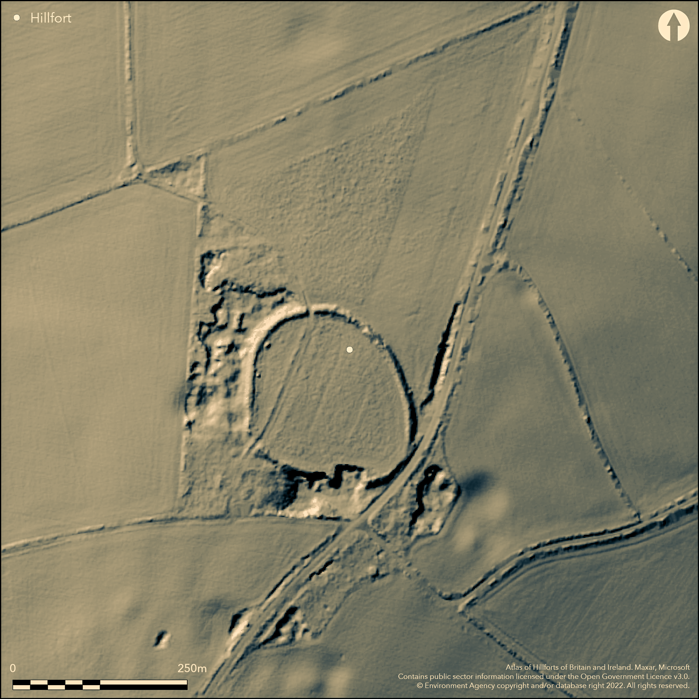
LiDAR 1m DTM Hillshade
Satellite Imagery
LiDAR 1m DTM Hillshade
Satellite Imagery
Scroll left/right to view further images.
HER: Oxfordshire 2302 (MOX305)
NMR: SP 22 SE 12 (332631)
SM: 1015412
NGR: SP 2993 2142
X: 429950 Y: 221450 (OSGB36)
Four miles S of Chipping Norton on one side of the top of a prominent gentle hill with good views, overlooking the Evenlode Valley. On the 1st Ed. OS map, in Plot 1705.. A univallate fort of 1.7ha, in the N and NE an earthen bank with some rubble, earthwork c.1.75m high to N and NE, c.12m wide, excavation (Bayne 1957) shows the rampart to have dry-stone front and rear revetting faces with rubble infill. A suggestion that the rampart may have a second phase dump construction. Single ditch shown by excavation to be U-shaped, c.2m deep and c.12m wide, may be re-cut, survives best in the W. Original entrance to N, c.16m wide, a simple gap, now a farm track, other breaks not original. Tree cover over much of the rampart which has been removed and damaged to the S by quarrying and road building. Dating is based on pottery from the excavation, Iron Age. Saxon spear heads found in the interior.
Citizen Science: ✓
Reliability of Data: Confirmed
Reliability of Interpretation: Confirmed
X: -174350 Y: 6780398 (EPSG: 3857)
Longitude: -1.566215088279362 Latitude: 51.89076199187774 (EPSG:4326)
Country: England
Current County or Unitary Authority: Oxfordshire
Historic County: Oxfordshire
Current Parish/Community/Council/Townland: Lyneham
None
| Extant | ✓ |
| Cropmark | ✗ |
| Likely Destroyed | ✗ |
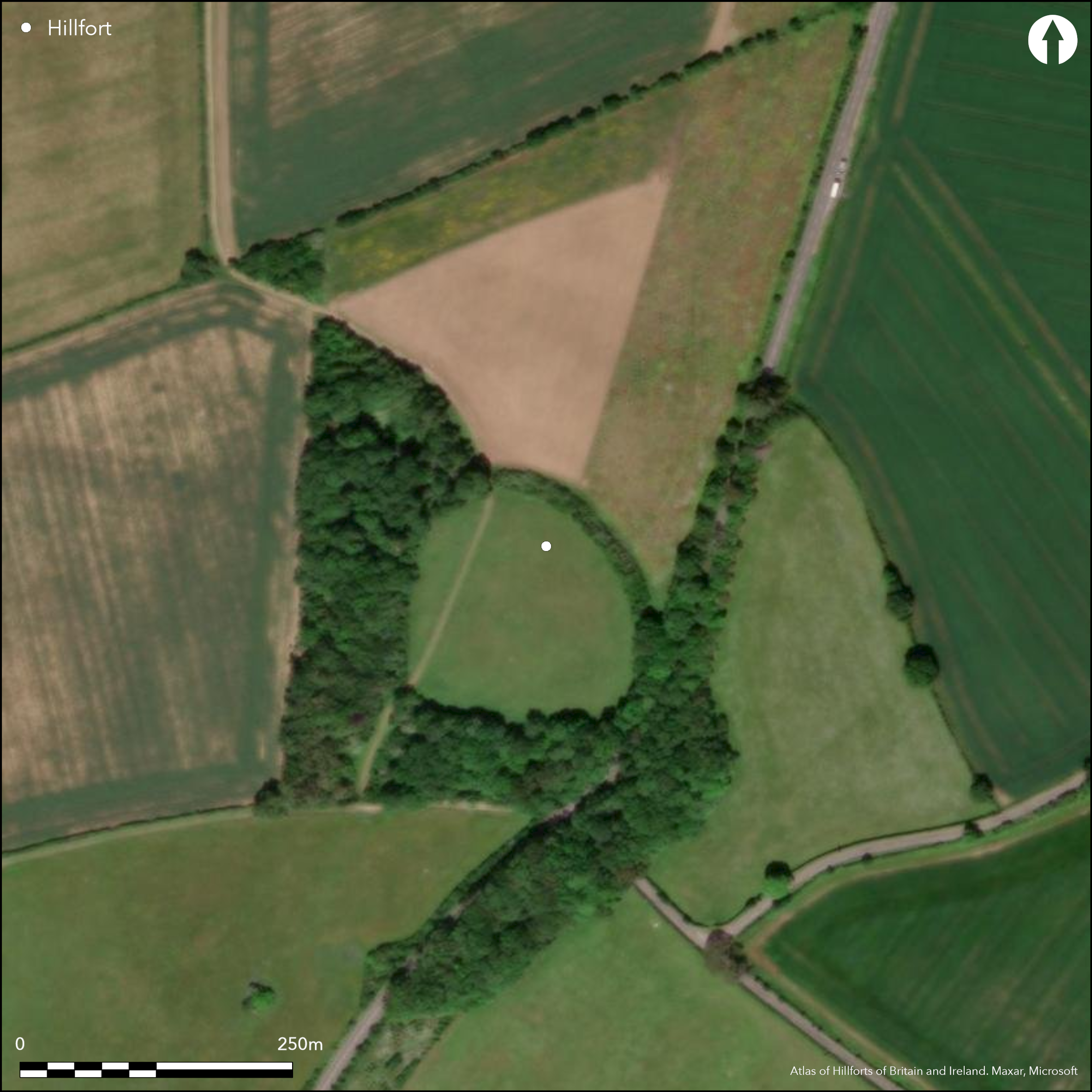
Single rampart upstanding for whole circuit except for a length at the S due to quarrying and being cut by the main road, A361. Whole circuit covered by trees, more extensive woodlands to W and S, ditch visible to N and W, interior has been ploughed but now pasture.
| Woodland | ✓ |
| Commercial Forestry Plantation | ✗ |
| Parkland | ✗ |
| Pasture (Grazing) | ✓ |
| Arable | ✗ |
| Scrub/Bracken | ✗ |
| Bare Outcrop | ✗ |
| Heather/Moorland | ✗ |
| Heath | ✗ |
| Built-up | ✗ |
| Coastal Grassland | ✗ |
| Other | ✗ |
On one side of the top of a prominent gentle hill with good views, overlooking the Evenlode Valley, partially follows the contours.
| Contour Fort | ✗ |
| Partial Contour Fort | ✓ |
| Promontory Fort | ✗ |
| Hillslope Fort | ✗ |
| Level Terrain Fort | ✗ |
| Marsh Fort | ✗ |
| Multiple Enclosure Fort | ✗ |
| Hilltop | ✓ |
| Coastal Promontory | ✗ |
| Inland Promontory | ✗ |
| Valley Bottom | ✗ |
| Knoll/Hillock/Outcrop | ✗ |
| Ridge | ✗ |
| Cliff/Plateau-edge/Scarp | ✗ |
| Hillslope | ✗ |
| Lowland | ✗ |
| Spur | ✗ |
Dominant Topographic Feature: Prominent but gentle hill with good views in all directions overlooking the Evenlode Valley
| North | ✗ |
| Northeast | ✗ |
| East | ✗ |
| Southeast | ✗ |
| South | ✗ |
| Southwest | ✗ |
| West | ✗ |
| Northwest | ✗ |
| Level | ✓ |
Altitude: 200.0m
N/A
Pottery from excavation (Bayne 1957), unspecific Iron Age, surface finds of Saxon spearheads (mentioned in HER)
Reliability: B - Medium
| Pre 1200BC | ✗ |
| 1200BC - 800BC | ✗ |
| 800BC - 400BC | ✓ |
| 400BC - AD50 | ✓ |
| AD50 - AD400 | ✗ |
| AD400 - AD 800 | ✗ |
| Post AD800 | ✗ |
| Unknown | ✗ |
| Pre Hillfort: | None |
| Post Hillfort: | None |
| Artefactual: | pottery from excavation |
On the 1st Ed. OS map. In Plot 1705. Minor excavations in 1956 by Oxford University Archaeological Society (Bayne 1957), across rampart and ditch. Geophysical survey 2006 (mentioned in HER).
| 1st Identified Written Reference (1705): | Plot |
| Excavation (1956): | Bayne 1957 |
| Geophysical Survey (2006): | mentioned in HER |
| 1st Identified Map Depiction (None): | 1st Ed. OS |
No excavation of interior, no surface features, pits suggested by geophysics.
Overlooks the River Evenlode valley.
| None | ✓ |
| Spring | ✗ |
| Stream | ✗ |
| Pool | ✗ |
| Flush | ✗ |
| Well | ✗ |
| Other | ✗ |
None
| No Known Features | ✓ |
| Round Stone Structures | ✗ |
| Rectangular Stone Structures | ✗ |
| Curvilinear Platforms | ✗ |
| Other Roundhouse Evidence | ✗ |
| Pits | ✗ |
| Quarry Hollows | ✗ |
| Other | ✗ |
None
| No Known Excavation | ✓ |
| Pits | ✗ |
| Postholes | ✗ |
| Roundhouses | ✗ |
| Rectangular Structures | ✗ |
| Roads/Tracks | ✗ |
| Quarry Hollows | ✗ |
| Other | ✗ |
| Nothing Found | ✗ |
Possible pits on geophysics
| No Known Geophysics | ✗ |
| Pits | ✓ |
| Roundhouses | ✗ |
| Rectangular Structures | ✗ |
| Roads/Tracks | ✗ |
| Quarry Hollows | ✗ |
| Other | ✗ |
| Nothing Found | ✗ |
Pottery, animal bones, worked bone from excavations.
| No Known Finds | ✗ |
| Pottery | ✓ |
| Metal | ✗ |
| Metalworking | ✗ |
| Human Bones | ✗ |
| Animal Bones | ✓ |
| Lithics | ✗ |
| Environmental | ✗ |
| Other | ✓ |
None
| APs Not Checked | ✓ |
| None | ✗ |
| Roundhouses | ✗ |
| Rectangular Structures | ✗ |
| Pits | ✗ |
| Postholes | ✗ |
| Roads/Tracks | ✗ |
| Other | ✗ |
Original entrance to N, c.16m wide, simple, now farm track, other breaks not original.
| None: | Unknown |
| 2: | None |
Guard Chambers: ✗
Chevaux de Frise: ✗
| 1. Simple Gap (North): | Simple gap to N, |
Single rampart and ditch, missing to the S due to quarrying and road building. In the N and NE earthen bank with some rubble, earthwork c.1.75m high to N and NE, c.12m wide, excavation shows the rampart to have dry-stone front and rear revetting faces with rubble infill. Single ditch shown by excavation to be U-shaped, c.2m deep and c.12m wide, may be re-cut.
| Area 1: | 1.7ha. |
| Total: | 1.7ha. |
Total Footprint Area: Noneha.
None
| ✗ | None |
| ✗ | Destroyed to S by quarrying and road building. |
| NE Quadrant: | None |
| SE Quadrant: | None |
| SW Quadrant: | None |
| NW Quadrant: | None |
| Total: | None |
| Partial Univallate | ✗ |
| Univallate | ✗ |
| Partial Bivallate | ✗ |
| Bivallate | ✗ |
| Partial Multivallate | ✗ |
| Multivallate | ✗ |
| Unknown | ✓ |
| Partial Univallate | ✗ |
| Univallate | ✗ |
| Partial Bivallate | ✗ |
| Bivallate | ✗ |
| Partial Multivallate | ✗ |
| Multivallate | ✗ |
Earthen bank with some rubble, earthwork c.1.75m high to N and NE, c.12m wide,
| None | ✗ |
| Earthen Bank | ✓ |
| Stone Wall | ✓ |
| Rubble | ✓ |
| Wall-walk | ✗ |
| Evidence of Timber | ✗ |
| Vitrification | ✗ |
| Other Burning | ✗ |
| Palisade | ✗ |
| Counter Scarp Bank | ✗ |
| Berm | ✗ |
| Unfinished | ✗ |
| Other | ✗ |
Excavation shows the rampart to have dry-stone front and rear revetting faces with rubble infill. Suggested single phase but may be two-phase with later dump rampart (HER).
| None | ✗ |
| Earthen Bank | ✓ |
| Stone Wall | ✓ |
| Murus Duplex | ✗ |
| Timber-framed | ✗ |
| Timber-laced | ✗ |
| Vitrification | ✗ |
| Other Burning | ✗ |
| Palisade | ✗ |
| Counter Scarp Bank | ✗ |
| Berm | ✗ |
| Unfinished | ✗ |
| No Known Excavation | ✗ |
| Other | ✗ |
| ✗ | None |
| ✓ | Single ditch shown by excavation to be U-shaped, c.2m deep and c.12m wide, may be re-cut. Survives best in the W. |
Number of Ditches: 1
| ✗ | None |
Bayne, N. 1957. Excavations at Lyneham Camp, Lyneham, Oxon. Oxoniensia, 22, 1-11.
Manning, P. and Leeds, E.T. 1921. An archaeological survey of Oxfordshire. London: Society of Antiquaries.
Page, W. (ed) 1907. The Victoria History of the County of Oxford, Vol II. London, 315.
Plot, R. 1705. The natural history of Oxfordshire, 343.
Atlas of Hillforts:
Wikidata:
This work is licensed under CC BY-SA 4.0![]()
![]()
![]() and should be cited as:
and should be cited as:
Lock, Gary and Ralston, Ian. 2024. Atlas of Hillforts of Britain and Ireland. Available at: https://hillforts.arch.ox.ac.uk
Document Version 1.1