LiDAR 1m DTM Hillshade
Satellite Imagery
LiDAR 1m DTM Hillshade
Satellite Imagery
Scroll left/right to view further images.
HER: Oxfordshire 1448 (MOX292)
NMR: SP 21 NW 2 (332307)
SM: 1014558
NGR: SP 22874 19543
X: 422885 Y: 219555 (OSGB36)
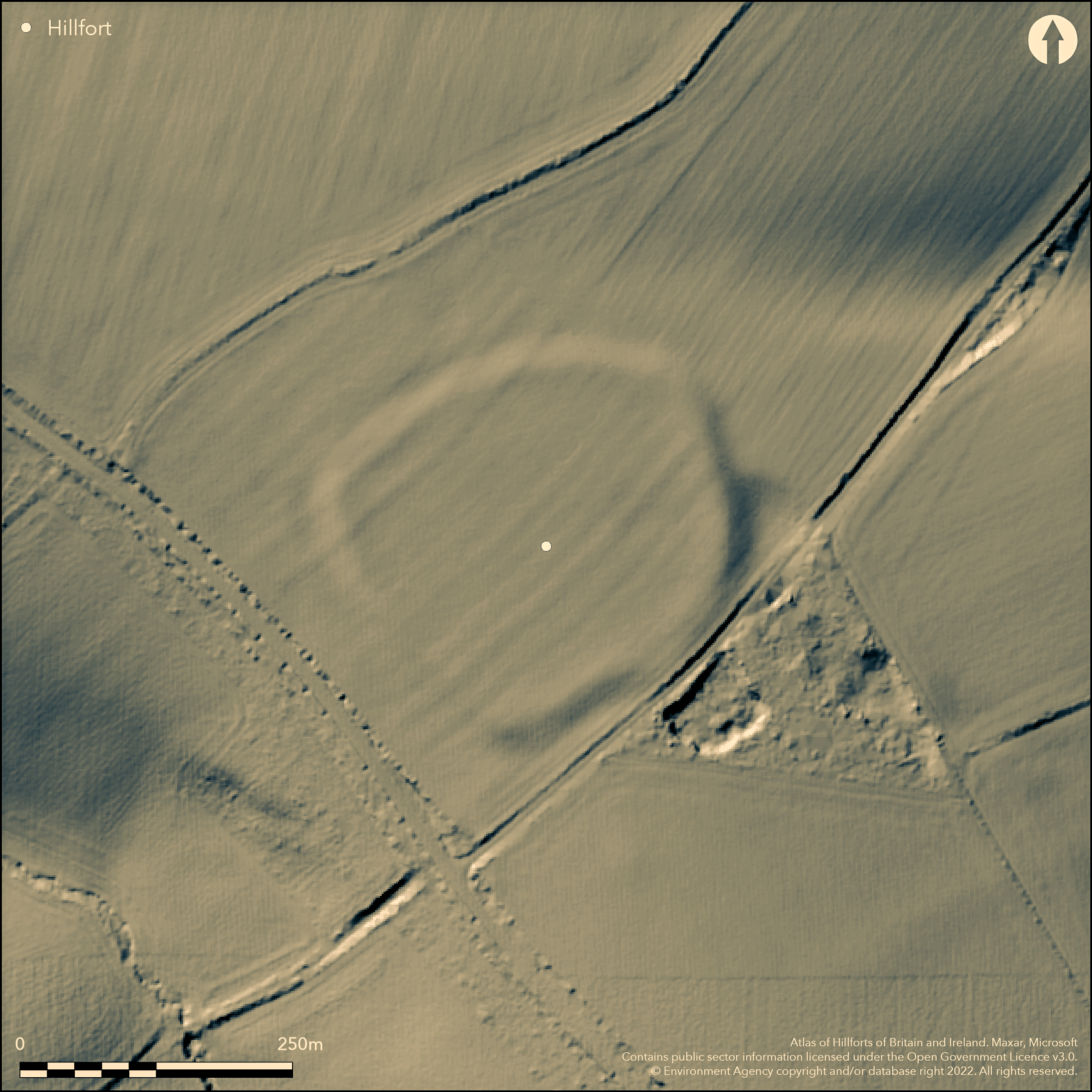
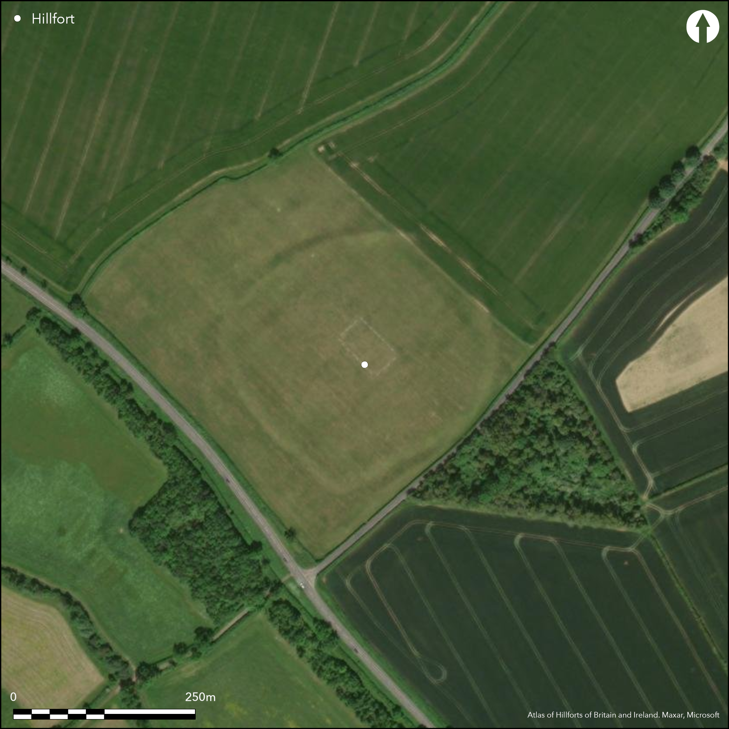
SW of Idbury, on the E side of a hill/ridge with good views to E, S and W. On the 1st Ed. OS map, in Plot (1705). Univallate with a single ditch for entire circuit, roughly oval enclosing 3.5ha. Whole site is severely ploughed out but visible on aerial photographs, the bank surviving to c.10m wide and 0.4m high maximum, ditch c15m wide. Many limestone slabs follow the line of the ramparts on the surface suggesting stone revetting. A possible short length of counterscarp bank shows on the aerial photograph at the N but unconfirmed. S single entrance on the NW, appears to be in-turned. Minimal investigations but Iron Age and Romano-British pottery, metalwork and bone reported as surface finds within and around the hillfort.
Citizen Science: ✗
Reliability of Data: Confirmed
Reliability of Interpretation: Confirmed
X: -185792 Y: 6777385 (EPSG: 3857)
Longitude: -1.6690002530197108 Latitude: 51.87405784314186 (EPSG:4326)
Country: England
Current County or Unitary Authority: Oxfordshire
Historic County: Gloucestershire
Current Parish/Community/Council/Townland: Idbury
None
| Extant | ✗ |
| Cropmark | ✓ |
| Likely Destroyed | ✗ |
Virtually ploughed away, rampart to a maximum of 0.4m high
| Woodland | ✗ |
| Commercial Forestry Plantation | ✗ |
| Parkland | ✗ |
| Pasture (Grazing) | ✗ |
| Arable | ✓ |
| Scrub/Bracken | ✗ |
| Bare Outcrop | ✗ |
| Heather/Moorland | ✗ |
| Heath | ✗ |
| Built-up | ✗ |
| Coastal Grassland | ✗ |
| Other | ✗ |
On a E side of hilltop/ridge with steep slopes to W and lesser slopes to E and S.
| Contour Fort | ✗ |
| Partial Contour Fort | ✓ |
| Promontory Fort | ✗ |
| Hillslope Fort | ✗ |
| Level Terrain Fort | ✗ |
| Marsh Fort | ✗ |
| Multiple Enclosure Fort | ✗ |
| Hilltop | ✓ |
| Coastal Promontory | ✗ |
| Inland Promontory | ✗ |
| Valley Bottom | ✗ |
| Knoll/Hillock/Outcrop | ✗ |
| Ridge | ✗ |
| Cliff/Plateau-edge/Scarp | ✗ |
| Hillslope | ✗ |
| Lowland | ✗ |
| Spur | ✗ |
Dominant Topographic Feature: Good views to E, S and W
| North | ✗ |
| Northeast | ✗ |
| East | ✗ |
| Southeast | ✗ |
| South | ✗ |
| Southwest | ✗ |
| West | ✗ |
| Northwest | ✗ |
| Level | ✓ |
Altitude: 198.0m
N/A
Iron Age and Romano-British pottery, surface finds.
Reliability: C - Low
| Pre 1200BC | ✗ |
| 1200BC - 800BC | ✗ |
| 800BC - 400BC | ✓ |
| 400BC - AD50 | ✓ |
| AD50 - AD400 | ✗ |
| AD400 - AD 800 | ✗ |
| Post AD800 | ✗ |
| Unknown | ✗ |
| Pre Hillfort: | None |
| Post Hillfort: | None |
| Artefactual: | surface finds of Iron Age pottery |
| Morphology/Earthwork/Typology: | Hillfort morphology and setting |
On the 1st Ed. OS map, in Plot (1705)
| 1st Identified Written Reference (1705): | Plot |
| 1st Identified Map Depiction (None): | 1st Ed. OS |
No evidence for internal features. Only surface finds of Iron Age and Romano-British pottery, metalwork and (animal?) bone found within and around the enclosure.
Possible water hole shows on aerial photograph outside the entrance at the NW
| None | ✓ |
| Spring | ✗ |
| Stream | ✗ |
| Pool | ✗ |
| Flush | ✗ |
| Well | ✗ |
| Other | ✗ |
None
| No Known Features | ✓ |
| Round Stone Structures | ✗ |
| Rectangular Stone Structures | ✗ |
| Curvilinear Platforms | ✗ |
| Other Roundhouse Evidence | ✗ |
| Pits | ✗ |
| Quarry Hollows | ✗ |
| Other | ✗ |
None
| No Known Excavation | ✓ |
| Pits | ✗ |
| Postholes | ✗ |
| Roundhouses | ✗ |
| Rectangular Structures | ✗ |
| Roads/Tracks | ✗ |
| Quarry Hollows | ✗ |
| Other | ✗ |
| Nothing Found | ✗ |
None
| No Known Geophysics | ✓ |
| Pits | ✗ |
| Roundhouses | ✗ |
| Rectangular Structures | ✗ |
| Roads/Tracks | ✗ |
| Quarry Hollows | ✗ |
| Other | ✗ |
| Nothing Found | ✗ |
None
| No Known Finds | ✗ |
| Pottery | ✓ |
| Metal | ✓ |
| Metalworking | ✗ |
| Human Bones | ✗ |
| Animal Bones | ✓ |
| Lithics | ✗ |
| Environmental | ✗ |
| Other | ✗ |
None
| APs Not Checked | ✓ |
| None | ✗ |
| Roundhouses | ✗ |
| Rectangular Structures | ✗ |
| Pits | ✗ |
| Postholes | ✗ |
| Roads/Tracks | ✗ |
| Other | ✗ |
A single entrance shows on aerial photography at the NW, looks to be slightly in-turned
| None: | None |
| 2: | None |
Guard Chambers: ✗
Chevaux de Frise: ✗
| 1. In-turned (North west): | Slightly in-turned |
Univallate with a single ditch for the entire circuit, bank now c.10m wide and 0.4m high maximum, ditch c15m wide. many limestone slabs follow the line of the ramparts on the surface suggesting stone revetting. A possible short length of counterscarp bank shows on the aerial photograph at the N but unconfirmed.
| Area 1: | 3.5ha. |
| Total: | 3.5ha. |
Total Footprint Area: Noneha.
None
| ✗ | None |
| ✓ | Possible counterscarp bank to NW but uncertain |
| NE Quadrant: | 1 |
| SE Quadrant: | 1 |
| SW Quadrant: | 1 |
| NW Quadrant: | 1 |
| Total: | 1 |
| Partial Univallate | ✗ |
| Univallate | ✓ |
| Partial Bivallate | ✗ |
| Bivallate | ✗ |
| Partial Multivallate | ✗ |
| Multivallate | ✗ |
| Unknown | ✗ |
| Partial Univallate | ✗ |
| Univallate | ✗ |
| Partial Bivallate | ✗ |
| Bivallate | ✗ |
| Partial Multivallate | ✗ |
| Multivallate | ✗ |
None
| None | ✗ |
| Earthen Bank | ✓ |
| Stone Wall | ✓ |
| Rubble | ✗ |
| Wall-walk | ✗ |
| Evidence of Timber | ✗ |
| Vitrification | ✗ |
| Other Burning | ✗ |
| Palisade | ✗ |
| Counter Scarp Bank | ✗ |
| Berm | ✗ |
| Unfinished | ✗ |
| Other | ✗ |
None
| None | ✓ |
| Earthen Bank | ✗ |
| Stone Wall | ✗ |
| Murus Duplex | ✗ |
| Timber-framed | ✗ |
| Timber-laced | ✗ |
| Vitrification | ✗ |
| Other Burning | ✗ |
| Palisade | ✗ |
| Counter Scarp Bank | ✗ |
| Berm | ✗ |
| Unfinished | ✗ |
| No Known Excavation | ✗ |
| Other | ✗ |
| ✗ | None |
| ✓ | None |
Number of Ditches: 1
| ✗ | None |
Manning, P. and Leeds, E.T. 1921. An archaeological survey of Oxfordshire. London: Society of Antiquaries.
Page, W. (ed) 1907. The Victoria History of the County of Oxford, Vol II. London, 315.
Plot, R. 1705. The natural history of Oxfordshire, 341.
Sutton, J.E.G. 1966. Iron-Age hill-forts and some other earthworks in Oxfordshire, Oxoniensia, 31, 28-42.
Steane, J. 1981. Idbury. S Midlands Archaeol, 79.
Atlas of Hillforts:
Wikidata:
This work is licensed under CC BY-SA 4.0![]()
![]()
![]() and should be cited as:
and should be cited as:
Lock, Gary and Ralston, Ian. 2024. Atlas of Hillforts of Britain and Ireland. Available at: https://hillforts.arch.ox.ac.uk
Document Version 1.1