LiDAR 1m DTM Hillshade
Satellite Imagery
LiDAR 1m DTM Hillshade
Satellite Imagery
Scroll left/right to view further images.
HER: Worcestershire MWR121 (WSM00339); Dudley 3252
NMR: SO 98 SW 4 (118705)
SM: 1003820
NGR: SO 9190 8170
X: 391872 Y: 281744 (OSGB36)
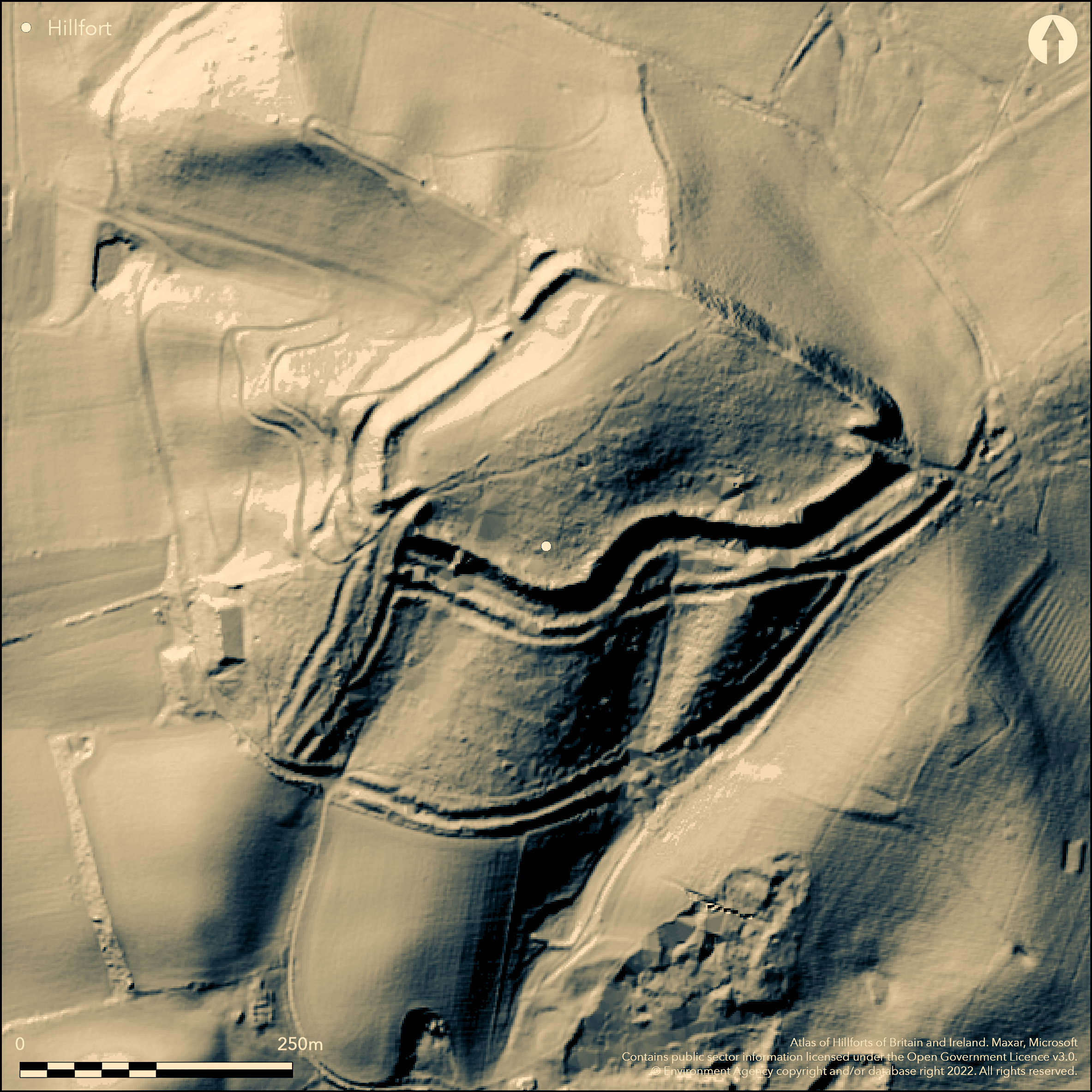
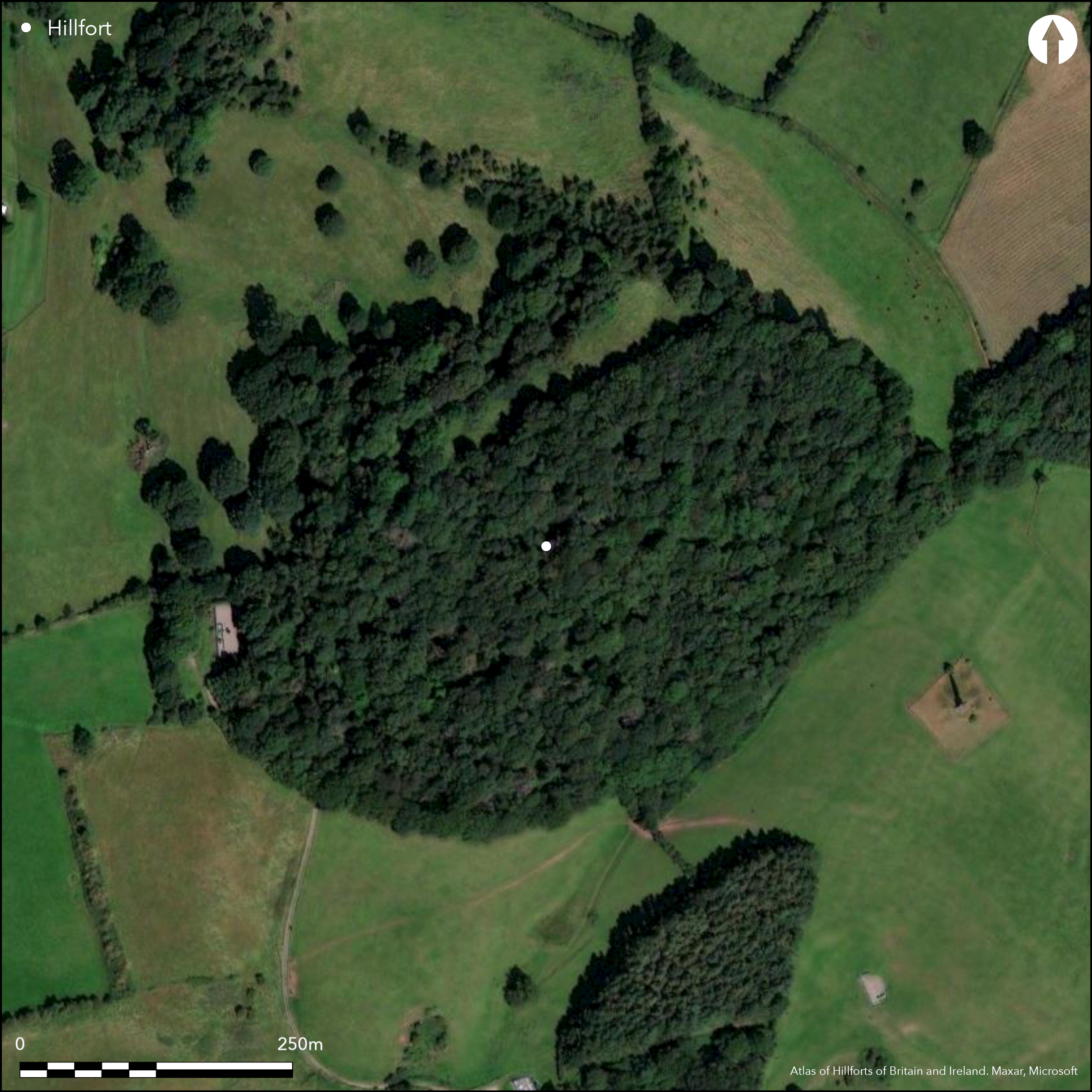
Mulivallate, strong and complex fort following more or less closely the irregular outline of the hill. Located at the extreme W end of the Clent Hills, where the range abruptly ends and overlooking the River Stour valley. On 1st Ed OS map (1885-1900). The site commands the wide Worcestershire Plain to the S and W. Generally follows the contours of the hill, the NE side is weakest with a single scarp. To the NW there is a double rampart with ditch and this increases in size southwards until it develops into triple ramparts, beyond which, at the SW angle, the innermost rampart in-turns to form a well-marked entrance. From here the banks increase in complexity to form a fourth and outer rampart. At this point, it has been suggested that this rampart forms an annexe of c. 5.5ha at the E angle, to be contained within the main body of the site. This is now disputed. Ramparts are best preserved on the S, the outer some 10m wide and 2.3m high, with a ditch 10m wide and c. 1.2m deep. To the N the inner ditch is silted and outer bank reduced to a lynchet type slope. The main, and heavily inturned, entrance is on the NE side. Old hollow-way, 2m deep, some 80m S of hillfort, mistaken for outworks. Small excavation of ten trial trenches in 1884.
Citizen Science: ✗
Reliability of Data: Confirmed
Reliability of Interpretation: Confirmed
X: -236108 Y: 6878905 (EPSG: 3857)
Longitude: -2.1209928146227943 Latitude: 52.43358062621529 (EPSG:4326)
Country: England; England
Current County or Unitary Authority: Worcestershire; West Midlands
Historic County: Worcestershire; Staffordshire
Current Parish/Community/Council/Townland: Hagley; Dudley
Fair in places. On Heritage at Risk Register (2015).
| Extant | ✓ |
| Cropmark | ✗ |
| Likely Destroyed | ✗ |
Built up areas nearby.
| Woodland | ✓ |
| Commercial Forestry Plantation | ✗ |
| Parkland | ✗ |
| Pasture (Grazing) | ✗ |
| Arable | ✗ |
| Scrub/Bracken | ✓ |
| Bare Outcrop | ✗ |
| Heather/Moorland | ✗ |
| Heath | ✗ |
| Built-up | ✗ |
| Coastal Grassland | ✗ |
| Other | ✗ |
Contour hillfort located at the extreme W end of the Clent Hills, where the range abruptly ends and overlooking the River Stour valley. The site commands the wide Worcestershire Plain to the S and W.
| Contour Fort | ✓ |
| Partial Contour Fort | ✗ |
| Promontory Fort | ✗ |
| Hillslope Fort | ✗ |
| Level Terrain Fort | ✗ |
| Marsh Fort | ✗ |
| Multiple Enclosure Fort | ✗ |
| Hilltop | ✓ |
| Coastal Promontory | ✗ |
| Inland Promontory | ✗ |
| Valley Bottom | ✗ |
| Knoll/Hillock/Outcrop | ✗ |
| Ridge | ✗ |
| Cliff/Plateau-edge/Scarp | ✗ |
| Hillslope | ✗ |
| Lowland | ✗ |
| Spur | ✗ |
Dominant Topographic Feature: Hill top
| North | ✗ |
| Northeast | ✗ |
| East | ✗ |
| Southeast | ✗ |
| South | ✗ |
| Southwest | ✗ |
| West | ✗ |
| Northwest | ✗ |
| Level | ✓ |
Altitude: 213.0m
The boundary between Worcs. and the West Midlands runs SW-NE through the hillfort and bounds the enclosure in the NE. The region has undergone several historic county changes - Worcestershire to 1966; Staffordshire 1966-1974; West Midlands 1974 onwards. Dudley now effectively a unitary.
Boundary Type: County
Two bronze rings found in excavation, now lost, one identified by British Museum as early Iron Age terret. Silver coin of Augustus (Tiberius), found at NE gate. Roman coins found nearby. All suggest possible Iron Age and Romano-British dates.
Reliability: C - Low
| Pre 1200BC | ✗ |
| 1200BC - 800BC | ✗ |
| 800BC - 400BC | ✓ |
| 400BC - AD50 | ✓ |
| AD50 - AD400 | ✓ |
| AD400 - AD 800 | ✗ |
| Post AD800 | ✗ |
| Unknown | ✗ |
| Pre Hillfort: | None |
| Post Hillfort: | None |
| Artefactual: | Bronze early Iron Age rings. |
| Other: | WWII recording. |
On 1st Ed OS map (1885-1900). Small excavation of ten trial trenches by E. B Marten in 1884. WWII details recorded in the CBA 'Defence of Britain Project', 1995-2002. WWII details under separate Monument No 1428065 and SAM No 1005900.
| Excavation (1884): | Directed by E.B. Marten. |
| Other (1923): | Scheduled |
| 1st Identified Map Depiction (None): | 1st Ed OS |
| Other (None): | CBA 'Defence of Britain Project'. |
Two bronze rings found in excavation, now lost, one identified by British Museum as early Iron Age terret. Silver coin of Augustus (Tiberius), found at NE gate. Roman coins found nearby.
None
| None | ✓ |
| Spring | ✗ |
| Stream | ✗ |
| Pool | ✗ |
| Flush | ✗ |
| Well | ✗ |
| Other | ✗ |
None
| No Known Features | ✓ |
| Round Stone Structures | ✗ |
| Rectangular Stone Structures | ✗ |
| Curvilinear Platforms | ✗ |
| Other Roundhouse Evidence | ✗ |
| Pits | ✗ |
| Quarry Hollows | ✗ |
| Other | ✗ |
1884 excavation - no details.
| No Known Excavation | ✗ |
| Pits | ✗ |
| Postholes | ✗ |
| Roundhouses | ✗ |
| Rectangular Structures | ✗ |
| Roads/Tracks | ✗ |
| Quarry Hollows | ✗ |
| Other | ✓ |
| Nothing Found | ✗ |
None
| No Known Geophysics | ✓ |
| Pits | ✗ |
| Roundhouses | ✗ |
| Rectangular Structures | ✗ |
| Roads/Tracks | ✗ |
| Quarry Hollows | ✗ |
| Other | ✗ |
| Nothing Found | ✗ |
Two bronze rings found in excavation, now lost, one identified by British Museum as early Iron Age terret. Silver coin of Augustus (Tiberius), found at NE gate. Roman coins found nearby.
| No Known Finds | ✗ |
| Pottery | ✗ |
| Metal | ✓ |
| Metalworking | ✗ |
| Human Bones | ✗ |
| Animal Bones | ✗ |
| Lithics | ✗ |
| Environmental | ✗ |
| Other | ✓ |
None
| APs Not Checked | ✓ |
| None | ✗ |
| Roundhouses | ✗ |
| Rectangular Structures | ✗ |
| Pits | ✗ |
| Postholes | ✗ |
| Roads/Tracks | ✗ |
| Other | ✗ |
Both the NE and SW entrances are heavily inturned. A winding track, bounded by ditches to the SW entrance is probably modern. The track to the NE entrance could be original, but has not been investigated.
| 2: | None |
| 2: | None |
Guard Chambers: ✗
Chevaux de Frise: ✗
| 1. In-turned (South west): | Heavily inturned. |
| 2. In-turned (North east): | Heavily inturned |
NE side is weakest with a single scarp. To the NW there is a double rampart with ditch and this increases in size S'wards until it develops into triple ramparts, beyond which, at the SW angle, the innermost rampart inturns to form a well-marked entrance. From here the banks increase in complexity to form a fourth and outer rampart.
| Area 1: | 2.9ha. |
| Total: | 2.9ha. |
Total Footprint Area: Noneha.
None
| ✗ | None |
| ✓ | None |
| NE Quadrant: | 1 |
| SE Quadrant: | 4 |
| SW Quadrant: | 3 |
| NW Quadrant: | 2 |
| Total: | 4 |
| Partial Univallate | ✓ |
| Univallate | ✗ |
| Partial Bivallate | ✓ |
| Bivallate | ✗ |
| Partial Multivallate | ✓ |
| Multivallate | ✗ |
| Unknown | ✗ |
| Partial Univallate | ✗ |
| Univallate | ✗ |
| Partial Bivallate | ✗ |
| Bivallate | ✗ |
| Partial Multivallate | ✗ |
| Multivallate | ✗ |
None
| None | ✗ |
| Earthen Bank | ✓ |
| Stone Wall | ✗ |
| Rubble | ✗ |
| Wall-walk | ✗ |
| Evidence of Timber | ✗ |
| Vitrification | ✗ |
| Other Burning | ✗ |
| Palisade | ✗ |
| Counter Scarp Bank | ✗ |
| Berm | ✗ |
| Unfinished | ✗ |
| Other | ✗ |
None
| None | ✓ |
| Earthen Bank | ✗ |
| Stone Wall | ✗ |
| Murus Duplex | ✗ |
| Timber-framed | ✗ |
| Timber-laced | ✗ |
| Vitrification | ✗ |
| Other Burning | ✗ |
| Palisade | ✗ |
| Counter Scarp Bank | ✗ |
| Berm | ✗ |
| Unfinished | ✗ |
| No Known Excavation | ✗ |
| Other | ✗ |
| ✗ | None |
| ✓ | Possibly three ditches. Ramparts are best preserved on the S, the outer with a ditch 10m wide and c. 1.2m deep. To the N the inner ditch is silted and outer bank reduced to a lynchet type slope. |
Number of Ditches: 3
| ✗ | A possible annexe of 5.5ha to the S within the main body of the hillfort is now questioned. |
Cooper, M. and Woodiwiss, S. 1993. Assessment of the effect of the proposed Kidderminster Bypass on the setting of Wychbury Camp, Unpublished report, Archaeological Service - Worcestershire County Council. Archaeological Service - Hereford and Worcester County Council, 163.
Page, W. and Willis-Bund, J.W. (eds) 1924. Victoria History of the Counties of England: a history of the County of Worcestershire, Vol IV, 424, 494, London: St Catherine Press.
Atlas of Hillforts:
Wikidata:
This work is licensed under CC BY-SA 4.0![]()
![]()
![]() and should be cited as:
and should be cited as:
Lock, Gary and Ralston, Ian. 2024. Atlas of Hillforts of Britain and Ireland. Available at: https://hillforts.arch.ox.ac.uk
Document Version 1.1