LiDAR 1m DTM Hillshade
Satellite Imagery
LiDAR 1m DTM Hillshade
Satellite Imagery
Scroll left/right to view further images.
HER: Worcestershire MWR404 (WSM00815)
NMR: SO 96 SE 2 (118403)
SM: None
NGR: SO9542 6445
X: 395370 Y: 264418 (OSGB36)
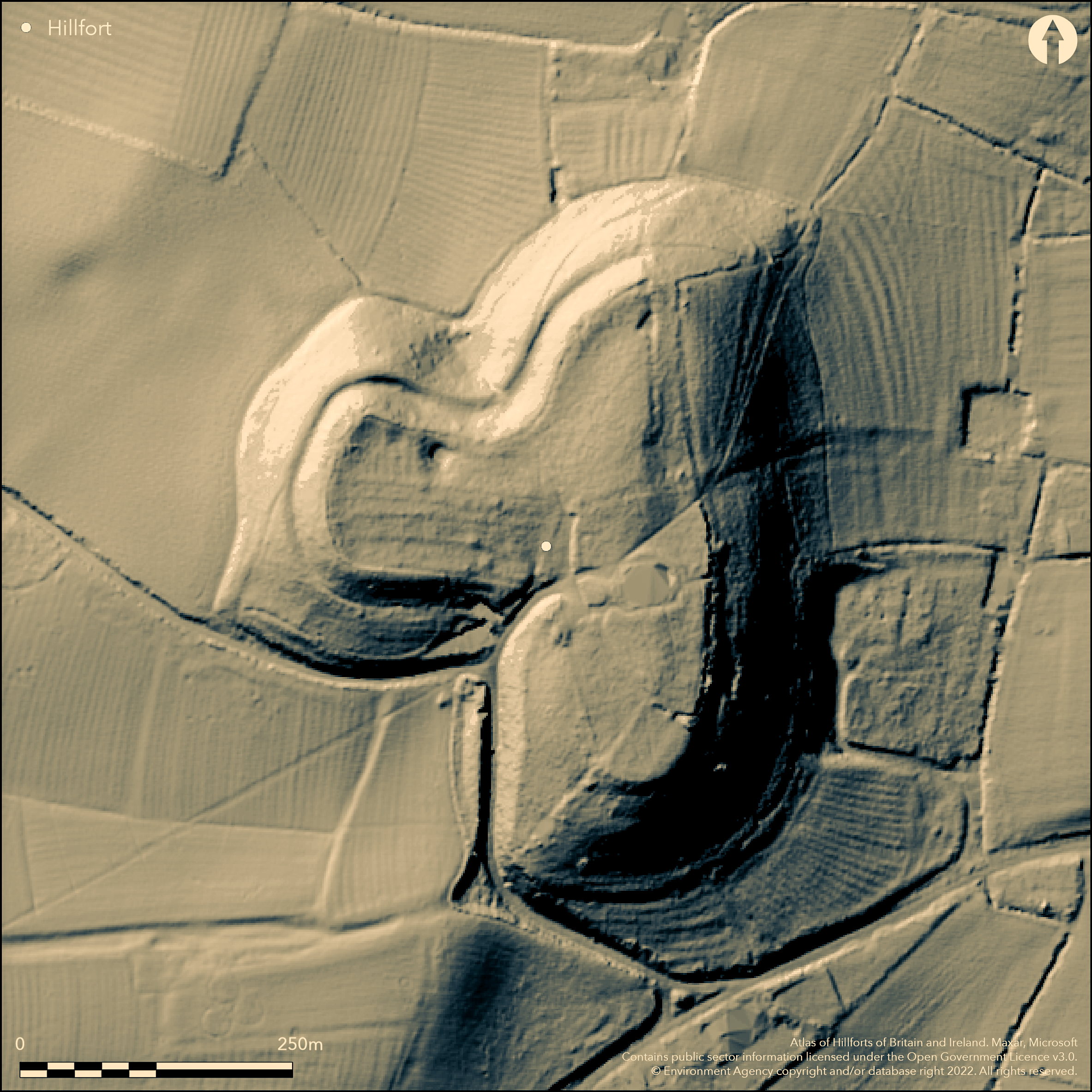
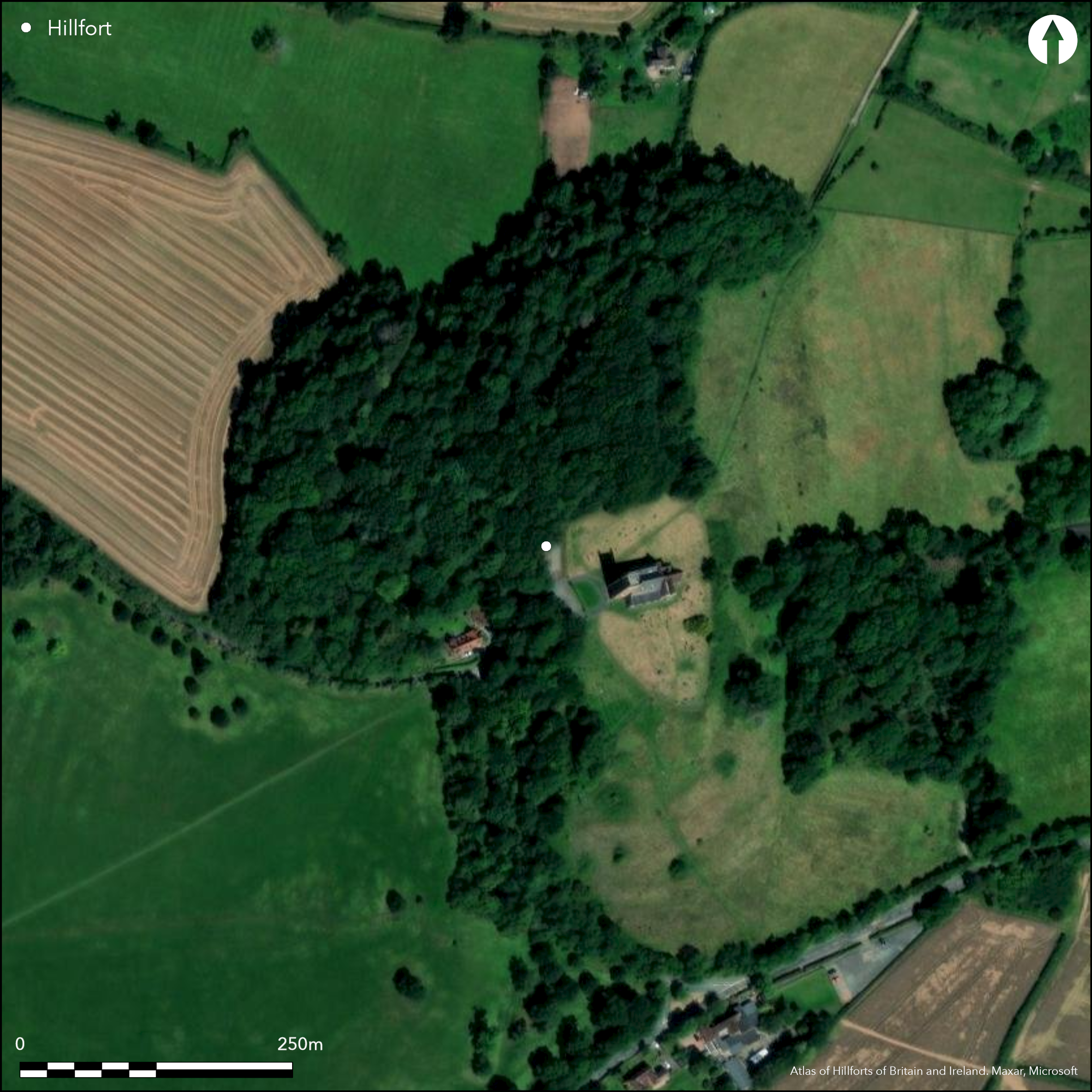
Recent work on the earthworks, around the summit of Church Hill, Hanbury, including stray finds and excavation of part of a roundhouse, suggest possible contour hillfort site. A detailed plan has been produced, but the exact line of the earthworks difficult to determine because of the 13th/15th century church and its renovation material and earthmoving on site. The church has a modern ha ha, with the earthworks beyond on the E side and are traceable in the wood to the N and W. This could be the line of an earlier enclosure, or could be a later Saxon monastic boundary. Two Iron Age coins were found in vicinity of site and in 1998 a small excavation found to SW of churchyard remains of a roundhouse and associated pottery of Iron Age date, with environmental material. Possible unspecified Roman activity has been suggested.
Citizen Science: ✗
Reliability of Data: Unconfirmed
Reliability of Interpretation: Unconfirmed
X: -230353 Y: 6850522 (EPSG: 3857)
Longitude: -2.069296970894138 Latitude: 52.27785565595676 (EPSG:4326)
Country: England
Current County or Unitary Authority: Worcestershire
Historic County: Worcestershire
Current Parish/Community/Council/Townland: Hanbury
Earthworks possibly upstanding in places.
| Extant | ✓ |
| Cropmark | ✗ |
| Likely Destroyed | ✗ |
Parish church on site.
| Woodland | ✓ |
| Commercial Forestry Plantation | ✗ |
| Parkland | ✗ |
| Pasture (Grazing) | ✗ |
| Arable | ✗ |
| Scrub/Bracken | ✓ |
| Bare Outcrop | ✗ |
| Heather/Moorland | ✗ |
| Heath | ✗ |
| Built-up | ✓ |
| Coastal Grassland | ✗ |
| Other | ✗ |
Contour fort located on summit of Church Hill, Hanbury.
| Contour Fort | ✓ |
| Partial Contour Fort | ✗ |
| Promontory Fort | ✗ |
| Hillslope Fort | ✗ |
| Level Terrain Fort | ✗ |
| Marsh Fort | ✗ |
| Multiple Enclosure Fort | ✗ |
| Hilltop | ✓ |
| Coastal Promontory | ✗ |
| Inland Promontory | ✗ |
| Valley Bottom | ✗ |
| Knoll/Hillock/Outcrop | ✗ |
| Ridge | ✗ |
| Cliff/Plateau-edge/Scarp | ✗ |
| Hillslope | ✗ |
| Lowland | ✗ |
| Spur | ✗ |
Dominant Topographic Feature: Hill top.
| North | ✗ |
| Northeast | ✗ |
| East | ✗ |
| Southeast | ✗ |
| South | ✗ |
| Southwest | ✗ |
| West | ✗ |
| Northwest | ✗ |
| Level | ✓ |
Altitude: 105.0m
N/A
Chance finds of siilver Iron Age coin and Roman coins in 1861, Iron Age pottery.
Reliability: C - Low
| Pre 1200BC | ✗ |
| 1200BC - 800BC | ✗ |
| 800BC - 400BC | ✗ |
| 400BC - AD50 | ✓ |
| AD50 - AD400 | ✗ |
| AD400 - AD 800 | ✗ |
| Post AD800 | ✗ |
| Unknown | ✗ |
| Pre Hillfort: | None |
| Post Hillfort: | None |
| Artefactual: | Iron Age and Roman coins. |
Salvage recording 1994. Small trench opened in 1998 in advance of graveyard extension. 2000 Watching Brief in hillfort interior found no evidence earlier than post-medieval.
| Other (1994): | Salvage recording. |
| Excavation (1998): | Small trench opened by Hereford and Worcester County Council Archaeology Service. |
| Other (2000): | Watching Brief, Birmingham University Field Archaeology Unit. |
Chance finds of Iron Age coins. Iron Age pottery from excavations, roundhouse.
Any water supply for the fort not determined, but possible as later monastery will have had an internal water supply.
| None | ✗ |
| Spring | ✗ |
| Stream | ✗ |
| Pool | ✗ |
| Flush | ✗ |
| Well | ✗ |
| Other | ✓ |
None
| No Known Features | ✓ |
| Round Stone Structures | ✗ |
| Rectangular Stone Structures | ✗ |
| Curvilinear Platforms | ✗ |
| Other Roundhouse Evidence | ✗ |
| Pits | ✗ |
| Quarry Hollows | ✗ |
| Other | ✗ |
Possible roundhouse evidence from 1998 excavations.
| No Known Excavation | ✗ |
| Pits | ✗ |
| Postholes | ✗ |
| Roundhouses | ✓ |
| Rectangular Structures | ✗ |
| Roads/Tracks | ✗ |
| Quarry Hollows | ✗ |
| Other | ✗ |
| Nothing Found | ✗ |
None
| No Known Geophysics | ✓ |
| Pits | ✗ |
| Roundhouses | ✗ |
| Rectangular Structures | ✗ |
| Roads/Tracks | ✗ |
| Quarry Hollows | ✗ |
| Other | ✗ |
| Nothing Found | ✗ |
Chance finds of silver Iron Age coin and Roman coins. Iron Age pottery.
| No Known Finds | ✗ |
| Pottery | ✓ |
| Metal | ✗ |
| Metalworking | ✗ |
| Human Bones | ✗ |
| Animal Bones | ✗ |
| Lithics | ✗ |
| Environmental | ✗ |
| Other | ✓ |
None
| APs Not Checked | ✓ |
| None | ✗ |
| Roundhouses | ✗ |
| Rectangular Structures | ✗ |
| Pits | ✗ |
| Postholes | ✗ |
| Roads/Tracks | ✗ |
| Other | ✗ |
No entrance defined at present..
| 0: | None |
| 2: | None |
Guard Chambers: ✗
Chevaux de Frise: ✗
Detailed plan has been produced, but the exact line of the earthworks difficult to determine because of the 13th/15th century church and its renovation material and earthmoving on site. The church has a modern ha ha, with the earthworks beyond on the E side and are traceable in the wood to the N and W. This could be the line of an earlier enclosure, or could be a later Saxon monastic boundary.
| Area 1: | Noneha. |
| Total: | Noneha. |
Total Footprint Area: Noneha.
None
| ✗ | Area not defined at present.. |
| ✗ | Although planned, exact line of enclosure cannot be specified yet. |
| NE Quadrant: | 0 |
| SE Quadrant: | 0 |
| SW Quadrant: | 0 |
| NW Quadrant: | 0 |
| Total: | 0 |
| Partial Univallate | ✗ |
| Univallate | ✗ |
| Partial Bivallate | ✗ |
| Bivallate | ✗ |
| Partial Multivallate | ✗ |
| Multivallate | ✗ |
| Unknown | ✓ |
| Partial Univallate | ✗ |
| Univallate | ✗ |
| Partial Bivallate | ✗ |
| Bivallate | ✗ |
| Partial Multivallate | ✗ |
| Multivallate | ✗ |
None
| None | ✓ |
| Earthen Bank | ✗ |
| Stone Wall | ✗ |
| Rubble | ✗ |
| Wall-walk | ✗ |
| Evidence of Timber | ✗ |
| Vitrification | ✗ |
| Other Burning | ✗ |
| Palisade | ✗ |
| Counter Scarp Bank | ✗ |
| Berm | ✗ |
| Unfinished | ✗ |
| Other | ✗ |
None
| None | ✓ |
| Earthen Bank | ✗ |
| Stone Wall | ✗ |
| Murus Duplex | ✗ |
| Timber-framed | ✗ |
| Timber-laced | ✗ |
| Vitrification | ✗ |
| Other Burning | ✗ |
| Palisade | ✗ |
| Counter Scarp Bank | ✗ |
| Berm | ✗ |
| Unfinished | ✗ |
| No Known Excavation | ✗ |
| Other | ✗ |
| ✗ | None |
| ✗ | Not specified at present. |
Number of Ditches: None
| ✗ | None |
Cook, M.J. 1998. Evaluation of land at St Mary's Church, Hanbury, Hereford and Worcester County Council Archaeology Service, Report No 678.
Dyer, C. 1991. Hanbury: Settlement & Society in a Woodland Landscape, Dept of English Local History Occasional Papers.
Atlas of Hillforts:
Wikidata:
This work is licensed under CC BY-SA 4.0![]()
![]()
![]() and should be cited as:
and should be cited as:
Lock, Gary and Ralston, Ian. 2024. Atlas of Hillforts of Britain and Ireland. Available at: https://hillforts.arch.ox.ac.uk
Document Version 1.1