LiDAR 1m DTM Hillshade
Satellite Imagery
LiDAR 1m DTM Hillshade
Satellite Imagery
Scroll left/right to view further images.
HER: Worcestershire MWR905 (WSM01874)
NMR: SP 07 NE 2 (328850)
SM: 1005294
NGR: SP095779
X: 409530 Y: 277903 (OSGB36)
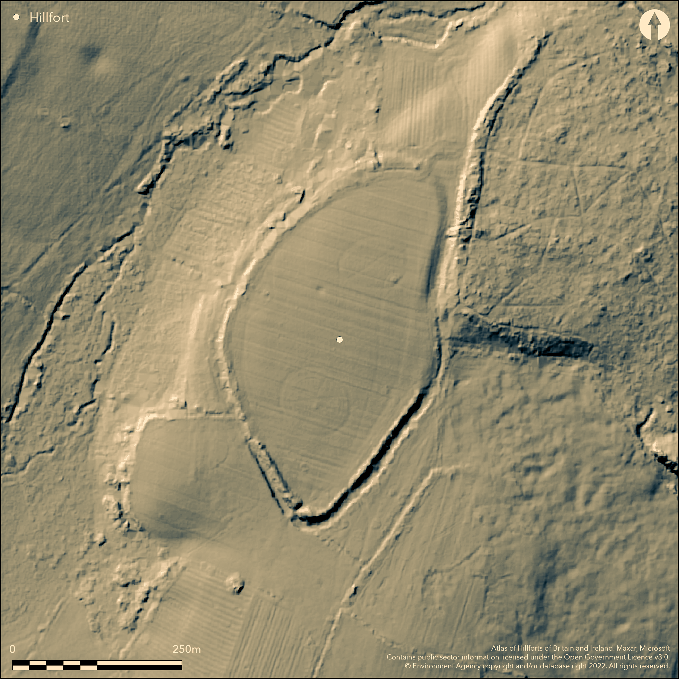
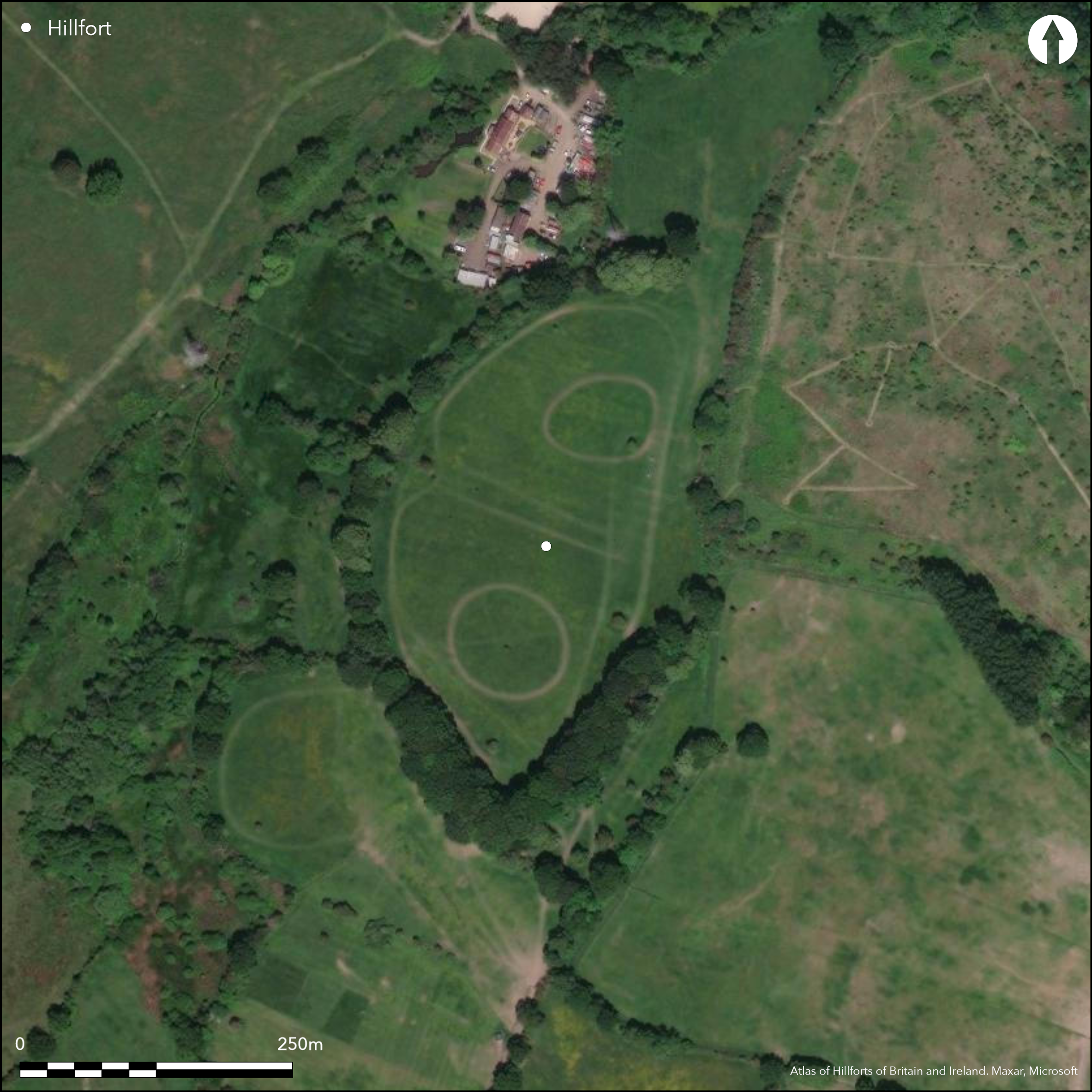
Oval, possibly univallate, contour hillfort sited on summit of gravel-capped hill overlooking left bank of River Cole. Topography important in location, as surrounded on three sides by valleys and possibly surrounded by marshy ground before drained, giving additional defence. Oval in shape, with internal area c. 4ha. Only remnants of ramparts remain to S and N, but just visible. Possibly multivallate in past, with massive inner defences and ditch, further bank, about half the size of inner,and third bank on W. Ditch confirmed by excavation, further ditches may now be buried features if formerly multivallate. Possible flattened berm. 1831 records show hillfort was traceable throughout, but by 1882 only intact for c. 100m at S end with only few remnants on N. Much of ramparts thrown into ditch c. 1865-71. Excavated by new field club of Birmingham Archaeological Society 1960's (Director M. Archibald), who sectioned rampart showing possible timber revetment. Resistivity and radar surveys in 2000 by University of Bradford Archaeological Services to determine interior structure of the earthen ramparts and banks. WWII Home Guard site. Entrances to N and S. On 1st Ed. OS map (1885-1900). Undated.
Citizen Science: ✗
Reliability of Data: Confirmed
Reliability of Interpretation: Confirmed
X: -207207 Y: 6872599 (EPSG: 3857)
Longitude: -1.8613708877342512 Latitude: 52.39902972487549 (EPSG:4326)
Country: England
Current County or Unitary Authority: Worcestershire
Historic County: Warwickshire
Current Parish/Community/Council/Townland: Wythall
1831 records show that the hillfort was traceable throughout, but by 1882 it was only only intact for c. 100m at the S end with only a few remnants on the N. Now, remnants only survive, but traceable with effort. Site used by 24th Warwickshire Home Guard in WWII as part of Birmingham defences. Old reclaimed quarry to NE.
| Extant | ✓ |
| Cropmark | ✗ |
| Likely Destroyed | ✗ |
Interior grazed pasture with banks mostly wooded with mature trees. Old quarry. Very near, and surrounded by, built-up areas.
| Woodland | ✓ |
| Commercial Forestry Plantation | ✗ |
| Parkland | ✗ |
| Pasture (Grazing) | ✓ |
| Arable | ✗ |
| Scrub/Bracken | ✗ |
| Bare Outcrop | ✗ |
| Heather/Moorland | ✗ |
| Heath | ✗ |
| Built-up | ✗ |
| Coastal Grassland | ✗ |
| Other | ✓ |
Contour hillfort sited on the summit of a gravel-capped hill overlooking the River Cole. The contours level off on the W side into a ditch.
| Contour Fort | ✓ |
| Partial Contour Fort | ✗ |
| Promontory Fort | ✗ |
| Hillslope Fort | ✗ |
| Level Terrain Fort | ✗ |
| Marsh Fort | ✗ |
| Multiple Enclosure Fort | ✗ |
| Hilltop | ✓ |
| Coastal Promontory | ✗ |
| Inland Promontory | ✗ |
| Valley Bottom | ✗ |
| Knoll/Hillock/Outcrop | ✗ |
| Ridge | ✗ |
| Cliff/Plateau-edge/Scarp | ✗ |
| Hillslope | ✗ |
| Lowland | ✗ |
| Spur | ✗ |
Dominant Topographic Feature: Gravel-capped hill overlooking the River Cole.
| North | ✗ |
| Northeast | ✗ |
| East | ✗ |
| Southeast | ✗ |
| South | ✗ |
| Southwest | ✗ |
| West | ✗ |
| Northwest | ✗ |
| Level | ✓ |
Altitude: 150.0m
N/A
None
Reliability: D - None
| Pre 1200BC | ✗ |
| 1200BC - 800BC | ✗ |
| 800BC - 400BC | ✗ |
| 400BC - AD50 | ✗ |
| AD50 - AD400 | ✗ |
| AD400 - AD 800 | ✗ |
| Post AD800 | ✗ |
| Unknown | ✓ |
| Pre Hillfort: | None |
| Post Hillfort: | Site used by 24th Warwickshire Home Guard in WWII as part of Birmingham defences. Old reclaimed quarry to NE. |
On 1st Ed. OS map (1885-1900). Excavated by new field club of Birmingham Archaeological Society in 1960's (Director M. Archibald). Resistivity and radar surveys in 2000 by University of Bradford Archaeological Services.
| Geophysical Survey (2000): | University of Bradford Archaeological Services to determine interior structure of earthen ramparts and banks. |
| 1st Identified Map Depiction (None): | 1st Ed OS. |
| Excavation (None): | Excavated by new field club of BAS. |
None
Water was confirmed in the ditch on SW side in 1872.
| None | ✗ |
| Spring | ✗ |
| Stream | ✗ |
| Pool | ✗ |
| Flush | ✗ |
| Well | ✗ |
| Other | ✓ |
None
| No Known Features | ✓ |
| Round Stone Structures | ✗ |
| Rectangular Stone Structures | ✗ |
| Curvilinear Platforms | ✗ |
| Other Roundhouse Evidence | ✗ |
| Pits | ✗ |
| Quarry Hollows | ✗ |
| Other | ✗ |
None
| No Known Excavation | ✓ |
| Pits | ✗ |
| Postholes | ✗ |
| Roundhouses | ✗ |
| Rectangular Structures | ✗ |
| Roads/Tracks | ✗ |
| Quarry Hollows | ✗ |
| Other | ✗ |
| Nothing Found | ✗ |
None
| No Known Geophysics | ✓ |
| Pits | ✗ |
| Roundhouses | ✗ |
| Rectangular Structures | ✗ |
| Roads/Tracks | ✗ |
| Quarry Hollows | ✗ |
| Other | ✗ |
| Nothing Found | ✗ |
None
| No Known Finds | ✓ |
| Pottery | ✗ |
| Metal | ✗ |
| Metalworking | ✗ |
| Human Bones | ✗ |
| Animal Bones | ✗ |
| Lithics | ✗ |
| Environmental | ✗ |
| Other | ✗ |
None
| APs Not Checked | ✓ |
| None | ✗ |
| Roundhouses | ✗ |
| Rectangular Structures | ✗ |
| Pits | ✗ |
| Postholes | ✗ |
| Roads/Tracks | ✗ |
| Other | ✗ |
Entrances possibly at S and N - type undefined. Possible SE causeway.
| 2: | None |
| 2: | None |
Guard Chambers: ✗
Chevaux de Frise: ✗
| 1. Simple Gap (South): | Form undefined. Simple gap default. |
| 2. Simple Gap (North): | Form undefined. Simple gap default. |
Only remnants of ramparts remain to S and N, but the enclosure can be traced around with some effort. Some earlier descriptions suggest that the fort, which now appears univallate, may have been multivallate in the past, with massive inner defences and ditch, a further bank, about half the size of the inner and a third bank to the W side. Ditch confirmed by excavation, but further ditches may now be buried features if, indeed , the enclosure is multivallate. There is some evidence for a flattened berm, in addition to the ramparts and ditch.
| Area 1: | 4.0ha. |
| Total: | 4.0ha. |
Total Footprint Area: Noneha.
None
| ✗ | None |
| ✗ | The total are estimated from 1872 records of Burgess. |
| NE Quadrant: | 2 |
| SE Quadrant: | 2 |
| SW Quadrant: | 3 |
| NW Quadrant: | 3 |
| Total: | 3 |
| Partial Univallate | ✗ |
| Univallate | ✗ |
| Partial Bivallate | ✓ |
| Bivallate | ✗ |
| Partial Multivallate | ✓ |
| Multivallate | ✗ |
| Unknown | ✗ |
| Partial Univallate | ✗ |
| Univallate | ✗ |
| Partial Bivallate | ✗ |
| Bivallate | ✗ |
| Partial Multivallate | ✗ |
| Multivallate | ✗ |
Heights of banks vary above ditch from c. just over 1m to c. 3.5m. Evidence of a flattened berm.
| None | ✗ |
| Earthen Bank | ✓ |
| Stone Wall | ✓ |
| Rubble | ✗ |
| Wall-walk | ✗ |
| Evidence of Timber | ✗ |
| Vitrification | ✗ |
| Other Burning | ✗ |
| Palisade | ✗ |
| Counter Scarp Bank | ✗ |
| Berm | ✓ |
| Unfinished | ✗ |
| Other | ✗ |
Section through ramparts showed of coarse gravel and clay. Probable holes of timber revetment at front plus retaining turfed wall behind. Resistivity and radar surveys in 2000 by University of Bradford Archaeological Services to determine interior structure of the earthen ramparts and banks.
| None | ✗ |
| Earthen Bank | ✓ |
| Stone Wall | ✓ |
| Murus Duplex | ✗ |
| Timber-framed | ✗ |
| Timber-laced | ✗ |
| Vitrification | ✗ |
| Other Burning | ✗ |
| Palisade | ✗ |
| Counter Scarp Bank | ✗ |
| Berm | ✗ |
| Unfinished | ✗ |
| No Known Excavation | ✗ |
| Other | ✗ |
| ✗ | None |
| ✓ | Shallow V-shaped ditch outside rampart with evidence of re-cutting c. 4.5m wide and nearly 2m deep. Ditch confirmed by excavation, but further ditches may now be buried features if, indeed, the enclosure is multivallate. |
Number of Ditches: 1
| ✗ | None |
Anon 1960. Note, West Midland Annual Archaeological Newsheet (CBA Group 8), 3/1960/2.
Debney, J. 2001. An investigation of the detection of structure in earthen banks and ramparts by geophysical means, Unpublished monograph.
Windle, B.C.A. and Willis-Bund, J.W. (eds) 1901.Victoria History of the Counties of England: a history of the County of Worcestershire, 1, 392-97, London: St Catherine Press.
Atlas of Hillforts:
Wikidata:
This work is licensed under CC BY-SA 4.0![]()
![]()
![]() and should be cited as:
and should be cited as:
Lock, Gary and Ralston, Ian. 2024. Atlas of Hillforts of Britain and Ireland. Available at: https://hillforts.arch.ox.ac.uk
Document Version 1.1