LiDAR 1m DTM Hillshade
Satellite Imagery
LiDAR 1m DTM Hillshade
Satellite Imagery
Scroll left/right to view further images.
HER: Worcestershire MWR1571 (WSM03943)
NMR: SO 94 SE 6 (11805)
SM: 1005331
NGR: SO957402
X: 395755 Y: 240233 (OSGB36)
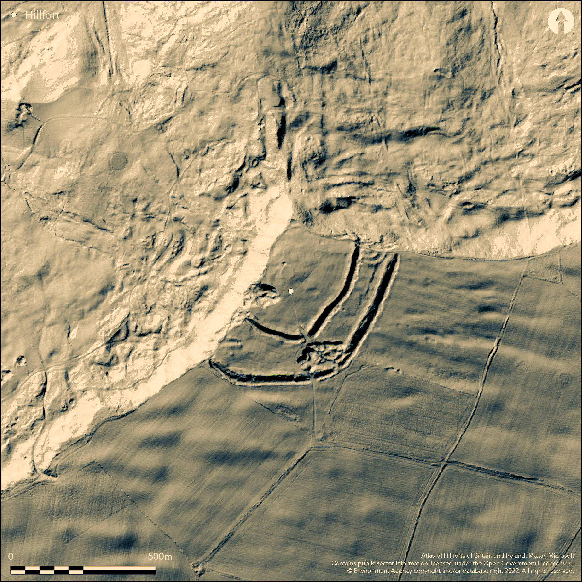
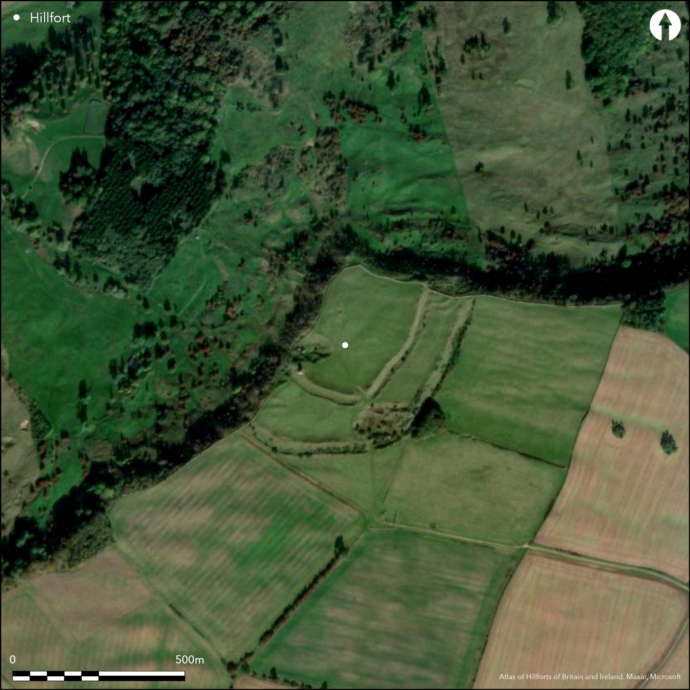
Famous multivallate promontory hillfort , strategically located at the NW end of Bredon Hill directly overlooking sharp bends of the River Avon. Two ramparts cut off the promontory with precipitous slopes of the hill to the NW defending the site. The hillfort is thus triangular in shape enclosing 7.1ha. Outer rampart 13.5m wide and 2.4m high has a V-shaped rock-cut ditch 10m wide and 4.5m deep with a 6.3m berm. The bank has a sloping rear and revetted dry-stone wall front. Inner rampart of glacis construction, with V-shaped ditch, is 33m wide and 11m high and probably had a timber breastwork. Excavation of SE inturned entrance (Hencken 1938) showed a phased construction: simple in Phase I, more complex in Phase II, and a possible two further entrances added later in Phase III. Skeletons found in the entrance have been C14 dated to 170-50 cal BC (Hurst and Western 2012). Excavation also found a circular hut behind the rampart with six postholes defining a porch. Finds included a fluted spearhead, of European parallel of c. 2nd century BC, and Iron Age pottery. Grazed upland pasture. Well-preserved. On 1st Ed OS map (1885-1900).
Citizen Science: ✓
Reliability of Data: Confirmed
Reliability of Interpretation: Confirmed
X: -229690 Y: 6811058 (EPSG: 3857)
Longitude: -2.063344368207263 Latitude: 52.060420815210996 (EPSG:4326)
Country: England; None
Current County or Unitary Authority: Worcestershire
Historic County: Gloucestershire
Current Parish/Community/Council/Townland: Eckington; Great Comberton; Kemerton
Well-preserved.
| Extant | ✓ |
| Cropmark | ✗ |
| Likely Destroyed | ✗ |
Grazed upland pasture. SSSI.
| Woodland | ✗ |
| Commercial Forestry Plantation | ✗ |
| Parkland | ✗ |
| Pasture (Grazing) | ✓ |
| Arable | ✗ |
| Scrub/Bracken | ✗ |
| Bare Outcrop | ✗ |
| Heather/Moorland | ✗ |
| Heath | ✗ |
| Built-up | ✗ |
| Coastal Grassland | ✗ |
| Other | ✗ |
Promontory hillfort , strategically located at the NW end of Bredon Hill directly overlooking sharp bends of the River Avon
| Contour Fort | ✗ |
| Partial Contour Fort | ✗ |
| Promontory Fort | ✓ |
| Hillslope Fort | ✗ |
| Level Terrain Fort | ✗ |
| Marsh Fort | ✗ |
| Multiple Enclosure Fort | ✗ |
| Hilltop | ✗ |
| Coastal Promontory | ✗ |
| Inland Promontory | ✓ |
| Valley Bottom | ✗ |
| Knoll/Hillock/Outcrop | ✗ |
| Ridge | ✗ |
| Cliff/Plateau-edge/Scarp | ✗ |
| Hillslope | ✗ |
| Lowland | ✗ |
| Spur | ✗ |
Dominant Topographic Feature: Precipitous scarp of Bredon Hill.
| North | ✗ |
| Northeast | ✗ |
| East | ✗ |
| Southeast | ✗ |
| South | ✗ |
| Southwest | ✗ |
| West | ✗ |
| Northwest | ✗ |
| Level | ✓ |
Altitude: 285.0m
Boundary Type: Parish/Townland
Iron Age pottery and 2nd century BC spearhead. Skeletons found in entrance passage way C14 dated to 170-50 cal BC (Hurst and Western 2012).
Reliability: B - Medium
| Pre 1200BC | ✗ |
| 1200BC - 800BC | ✗ |
| 800BC - 400BC | ✗ |
| 400BC - AD50 | ✓ |
| AD50 - AD400 | ✗ |
| AD400 - AD 800 | ✗ |
| Post AD800 | ✗ |
| Unknown | ✗ |
| Pre Hillfort: | None |
| Post Hillfort: | None |
| Artefactual: | Iron Age pottery and 2nd century BC spearhead. |
| C14: | Skeletons. |
On 1st Ed OS map (1885-1900). Excavations by B.C.A. Windle 1905 and T.C. Hencken 1935-37. Air photograph interpretation RCHME - Air Photography Programme 1992-96. General site interpretation.
| Excavation (1905): | Director B.C.A. Windle. |
| Other (1970): | Visited by Hillfort Study Group |
| 1st Identified Map Depiction (None): | 1st Ed OS. |
| Excavation (None): | Director T.C. Hencken. |
| Other (None): | Air photograph interpretation RCHME - Air Photography Programme. General site interpretation. |
Hencken (1938) found 'massacre' of c. 60 mutilated adult males outside inner gate. Weapons and burnt material indicate a fierce struggle. Also Iron Age pottery, metal items, human and animal bone and other artefacts and material found in the excavations.
None
| None | ✓ |
| Spring | ✗ |
| Stream | ✗ |
| Pool | ✗ |
| Flush | ✗ |
| Well | ✗ |
| Other | ✗ |
None
| No Known Features | ✓ |
| Round Stone Structures | ✗ |
| Rectangular Stone Structures | ✗ |
| Curvilinear Platforms | ✗ |
| Other Roundhouse Evidence | ✗ |
| Pits | ✗ |
| Quarry Hollows | ✗ |
| Other | ✗ |
Excavation also found a circular hut behind the rampart with six postholes defining a porch.
| No Known Excavation | ✗ |
| Pits | ✗ |
| Postholes | ✓ |
| Roundhouses | ✓ |
| Rectangular Structures | ✗ |
| Roads/Tracks | ✗ |
| Quarry Hollows | ✗ |
| Other | ✓ |
| Nothing Found | ✗ |
None
| No Known Geophysics | ✓ |
| Pits | ✗ |
| Roundhouses | ✗ |
| Rectangular Structures | ✗ |
| Roads/Tracks | ✗ |
| Quarry Hollows | ✗ |
| Other | ✗ |
| Nothing Found | ✗ |
Hencken (1938) found 'massacre' of c. 60 mutilated adult males outside inner gate. Weapons and burnt material indicate a fierce struggle. Iron Age pottery, metal items, weapons, human and animal bone found in the excavations.
| No Known Finds | ✗ |
| Pottery | ✓ |
| Metal | ✓ |
| Metalworking | ✓ |
| Human Bones | ✓ |
| Animal Bones | ✓ |
| Lithics | ✓ |
| Environmental | ✓ |
| Other | ✓ |
1992-1996 Air photograph interpretation RCHME - Air Photography Programme. General site interpretation.
| APs Not Checked | ✗ |
| None | ✗ |
| Roundhouses | ✗ |
| Rectangular Structures | ✗ |
| Pits | ✗ |
| Postholes | ✗ |
| Roads/Tracks | ✗ |
| Other | ✓ |
Possible central SE position. Excavation has shown a phased construction: simple in Phase I, more complex in Phase II, with a 40m passageway with revetted walls between inturns and evidence of timber bridge over, and a possible two further entrances added later at the rampart ends near the cliffs, in Phase III.
| 3: | None |
| 2: | The exact position of these entrances has not been determined but central entrance possibly to SE. |
Guard Chambers: ✗
Chevaux de Frise: ✗
| 1. In-turned (South east): | Possible central SE position. Revetted walls between inturns. |
| 1. Passage-way/Corridor (South east): | 40m passageway with revetted walls between inturns and evidence of timber bridge over, |
Two ramparts cut off the promontory with precipitous slopes of the hill to the NW defending the site. The hillfort is thus triangular in shape, Outer rampart 13.5m wide and 2.4m high has a V-shaped rock-cut ditch 10m wide and 4.5m deep with a 6.3m berm. The bank has a sloping rear and revetted drystone wall front. Inner rampart of glacis construction, with V-shaped ditch, is 33m wide and 11m high and probably had a timber breastwork.
| Area 1: | 7.1ha. |
| Total: | 7.1ha. |
Total Footprint Area: Noneha.
None
| ✓ | Three phases to site. |
| ✗ | None |
| NE Quadrant: | 2 |
| SE Quadrant: | 2 |
| SW Quadrant: | 2 |
| NW Quadrant: | 0 |
| Total: | 2 |
| Partial Univallate | ✗ |
| Univallate | ✗ |
| Partial Bivallate | ✓ |
| Bivallate | ✗ |
| Partial Multivallate | ✗ |
| Multivallate | ✗ |
| Unknown | ✗ |
| Partial Univallate | ✗ |
| Univallate | ✗ |
| Partial Bivallate | ✗ |
| Bivallate | ✗ |
| Partial Multivallate | ✗ |
| Multivallate | ✗ |
None
| None | ✗ |
| Earthen Bank | ✓ |
| Stone Wall | ✓ |
| Rubble | ✗ |
| Wall-walk | ✗ |
| Evidence of Timber | ✗ |
| Vitrification | ✗ |
| Other Burning | ✗ |
| Palisade | ✗ |
| Counter Scarp Bank | ✗ |
| Berm | ✓ |
| Unfinished | ✗ |
| Other | ✗ |
Rampart details all from excavation. Inner rampart probably had a timber breastwork. 6.3m berm.
| None | ✗ |
| Earthen Bank | ✓ |
| Stone Wall | ✓ |
| Murus Duplex | ✗ |
| Timber-framed | ✓ |
| Timber-laced | ✗ |
| Vitrification | ✗ |
| Other Burning | ✗ |
| Palisade | ✗ |
| Counter Scarp Bank | ✗ |
| Berm | ✓ |
| Unfinished | ✗ |
| No Known Excavation | ✗ |
| Other | ✗ |
| ✗ | None |
| ✓ | Two V-shaped ditches, outer rock-cut. |
Number of Ditches: 2
| ✗ | None |
Brown, I.W. 2009. Beacons in the landscape. The hillforts of England and Wales, Oxord: Windgather Press/Oxbow, 103 and various.
Hencken T.C. 1938: The excavation of the Iron Age camp on Bredon Hill, Gloucestershire, 1935-37, Archaeol J, 05, 1-111.
Hurst, D. and Western, G. 2012. New light on Kemerton Camp. Royal Archaeological Institute Newsletter, 43, 6-7.
Windle, B.C.A. and Willis-Bund, J.W. (eds) 1901. Victoria History of the Counties of England: a history of the County of Worcestershire, 1.
Atlas of Hillforts:
Wikidata:
This work is licensed under CC BY-SA 4.0![]()
![]()
![]() and should be cited as:
and should be cited as:
Lock, Gary and Ralston, Ian. 2024. Atlas of Hillforts of Britain and Ireland. Available at: https://hillforts.arch.ox.ac.uk
Document Version 1.1