
LiDAR 1m DTM Hillshade
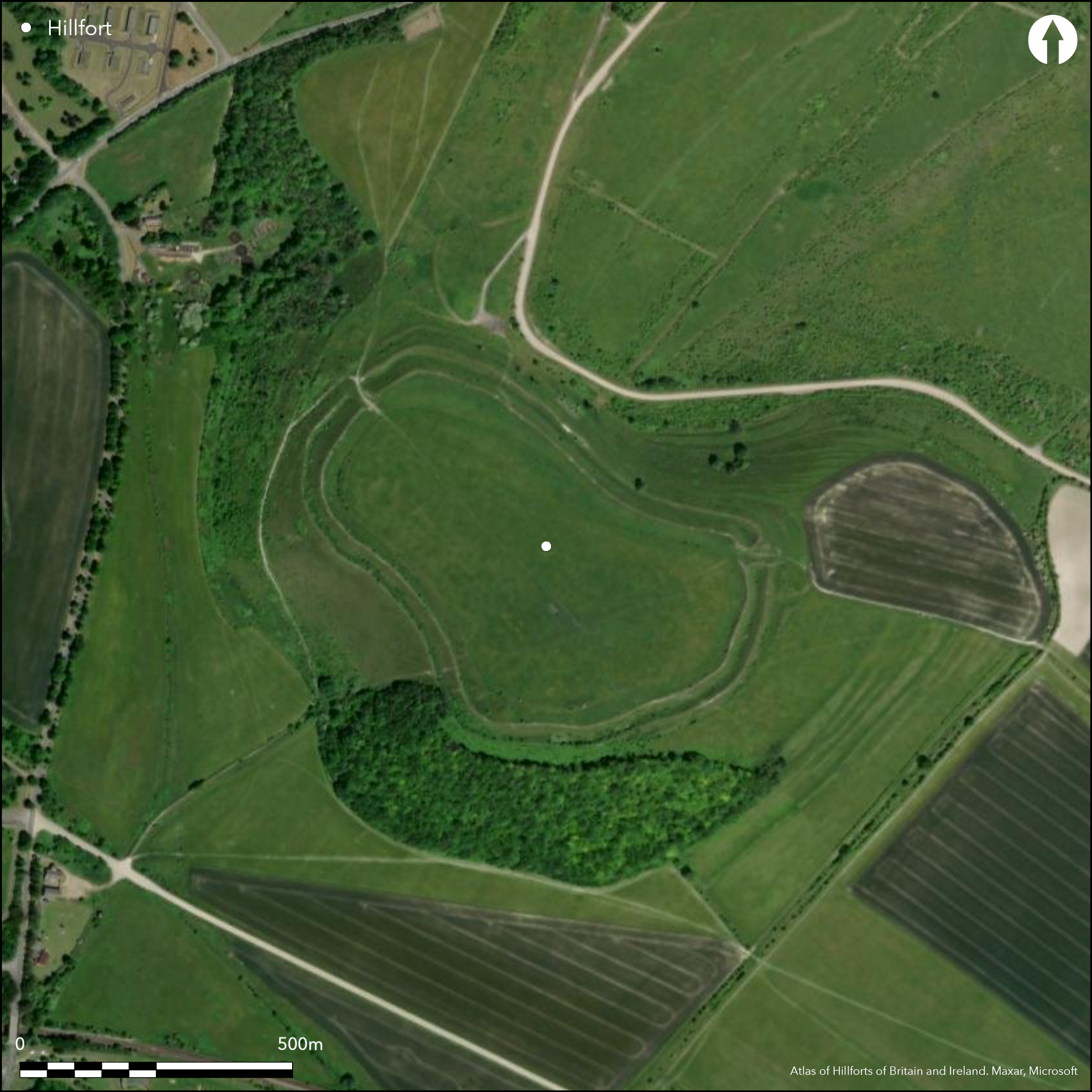
Satellite Imagery
LiDAR 1m DTM Hillshade
Satellite Imagery
Scroll left/right to view further images.
HER: Wiltshire and Swindon MWI858 (None)
NMR: ST 84 NE 4 (207399)
SM: 1010195
NGR: ST89854565
X: 389852 Y: 145653 (OSGB36)
Large, dominant and well-preserved, contour hillfort of 9.7 ha sited at S end of chalk spur, a S extension of Salisbury Plain. Strategically sited where valley of River Wylye widens to W giving access to lower lying ares of clay and Reading Beds. . Paired with Scratchbury (Atlas No 0411) 1km to SW separated by Middle Hill and located in Ministry of Defence Salisbury Training Area. Very steep surrounding slopes W and S, steep on E, moderate on N along ridge, defensive circuit reflecting this topography. Internal area 9.7ha. Defences consist of inner rampart and ditch and counterscarp bank, apart from NW also protected by two additional ramparts and ditches. To S and E base of outer rampart indistinguishable from steep natural scarp. Lynchet within enclosure runs parallel to inner rampart. Two strip lynchets on NE and SE slopes below the hillfort to c. 2m high. In S angle of enclosure three bowl barrows between inner rampart and internal lynchet. Two original entrances, to NW, 6m to 8m wide, to E, 5m to 6m wide. Trench dug for cistern pipe from highest point of interior to NW entrance 1922. Pits found, some intersecting each other, containing early Iron Age pottery, animal remains, quernstones, metalwork and iron hoops (parts of chariot wheel). Rescue work carried out by Ministry of Works in 1957 also recovered Iron Age pottery. Roman finds, mainly coins, found plough layer within interior, but no Roman features recorded during the excavations. Traces of 'Celtic' fields pre-dating ramparts in interior show site much settled by time hillfort constructed, and earlier activity also proved with bowl barrows on site. Interior long cultivated, but now rough upland pasture. On Ist Ed. OS map (1887)
Citizen Science: ✓
Reliability of Data: Confirmed
Reliability of Interpretation: Confirmed
X: -238967 Y: 6658513 (EPSG: 3857)
Longitude: -2.1466765621823862 Latitude: 51.20993537324019 (EPSG:4326)
Country: England
Current County or Unitary Authority: Wiltshire
Historic County: Wiltshire
Current Parish/Community/Council/Townland: Warminster
Good rampart condition, but interior long under cultivation in past obscured and obliterated features.
| Extant | ✓ |
| Cropmark | ✗ |
| Likely Destroyed | ✗ |
Interior long under cultivation, lynchet running immediately behind inner rampart result of soil accumulation from this cultivation, but present day land use rough upland pasture, SSSI.
| Woodland | ✗ |
| Commercial Forestry Plantation | ✗ |
| Parkland | ✗ |
| Pasture (Grazing) | ✓ |
| Arable | ✗ |
| Scrub/Bracken | ✗ |
| Bare Outcrop | ✗ |
| Heather/Moorland | ✗ |
| Heath | ✗ |
| Built-up | ✗ |
| Coastal Grassland | ✗ |
| Other | ✗ |
Large, dominant and well-preserved contour hillfort sited at S end of chalk spur, a S extension of Salisbury Plain. Strategically sited where valley of River Wylye widens to W giving access to lower lying ares of clay and Reading Beds. Very steep surrounding slopes W and S, steep on E, moderate on N along ridge, the defensive circuit reflecting this topography.
| Contour Fort | ✓ |
| Partial Contour Fort | ✗ |
| Promontory Fort | ✗ |
| Hillslope Fort | ✗ |
| Level Terrain Fort | ✗ |
| Marsh Fort | ✗ |
| Multiple Enclosure Fort | ✗ |
Located at the southern end of a chalk spur projecting from the southern edge of the Marlborough Downs massif and overlooking the vale below. Strategically sited where the valley of the River Wylye widens to the west. Important acccess point.
| Hilltop | ✗ |
| Coastal Promontory | ✗ |
| Inland Promontory | ✗ |
| Valley Bottom | ✗ |
| Knoll/Hillock/Outcrop | ✗ |
| Ridge | ✗ |
| Cliff/Plateau-edge/Scarp | ✗ |
| Hillslope | ✗ |
| Lowland | ✗ |
| Spur | ✓ |
Dominant Topographic Feature: Chalk spur
| North | ✗ |
| Northeast | ✗ |
| East | ✗ |
| Southeast | ✗ |
| South | ✗ |
| Southwest | ✗ |
| West | ✗ |
| Northwest | ✗ |
| Level | ✓ |
Altitude: 208.0m
N/A
Middle to late Iron Age (post 300 BC) or Romano-British on basis of artefacts recovered from mound overlain by tail of inner rampart, glass bead being dated to post 300 BC and finds from pits within interior.
Reliability: B - Medium
| Pre 1200BC | ✗ |
| 1200BC - 800BC | ✗ |
| 800BC - 400BC | ✗ |
| 400BC - AD50 | ✓ |
| AD50 - AD400 | ✗ |
| AD400 - AD 800 | ✗ |
| Post AD800 | ✗ |
| Unknown | ✗ |
| Pre Hillfort: | None |
| Post Hillfort: | None |
| Artefactual: | On basis of artefacts recovered from mound overlain by tail of inner rampart, glass bead being dated to post 300BC and finds from pits within interior. |
In Aubrey's Monumenta Britannica (1665-1693). On Ist Ed. OS map (1887). Partial excavations in the 19th century - no details. Trench for cistern pipe from summit to NW entrance, published by Maud Cunnington 1923. Rescue work carried out by Ministry of Works in 1957. Undated measured survey RCHME: South Wiltshire Project, ref. no. 831573. Undated field survey RCHME: Salisbury Plain Training Area, ref. no. 888341.1996 evaluation South Range Road - Gifford and Partners. 1998 Measured survey E of Battlesbury Bowl - Wessex Archaeology. 1887 OS 2,500 map.
| 1st Identified Map Depiction (1887): | OS 2,500 map. |
| Excavation (1922): | Published by M.E. Cunnington. |
| Excavation (1957): | Rescue work carried out by Ministry of Works. |
| Other (1984): | Visit by Hillfort Study Group |
| Other (1996): | Evaluation South Range Road - Gifford and Partners. |
| Other (1998): | Measured survey E of Battlesbury Bowl - Wessex Archaeology. |
| 1st Identified Written Reference (None): | In Aubrey's Monumenta Britannica. |
| Earthwork Survey (None): | Measured survey RCHME: South Wiltshire Project. |
| Earthwork Survey (None): | Field survey RCHME: Salisbury Plain Training Area. |
| Excavation (None): | Partial excavations - no details. |
In S angle of the enclosure three bowl barrows between inner rampart and internal lynchet. Pits found, some intersecting each other, containing early Iron Age pottery, animal remains, quernstones, metalwork and iron hoops (parts of chariot wheel). Rescue work carried out by Ministry of Works in 1957 also recovered Iron Age pottery. Roman finds, mainly coins, found plough layer within interior, but no Roman features recorded during the excavations. An Iron Age inhumation cemetery near the NW entrance. Several human skeletons, skulls and part of a horse skeleton have been found at various times. Aerial Photographs suggest possible field system in interior.
None
| None | ✓ |
| Spring | ✗ |
| Stream | ✗ |
| Pool | ✗ |
| Flush | ✗ |
| Well | ✗ |
| Other | ✗ |
In S angle of the enclosure three bowl barrows between inner rampart and internal lynchet.
| No Known Features | ✗ |
| Round Stone Structures | ✗ |
| Rectangular Stone Structures | ✗ |
| Curvilinear Platforms | ✗ |
| Other Roundhouse Evidence | ✗ |
| Pits | ✗ |
| Quarry Hollows | ✗ |
| Other | ✓ |
Nine storage pits found by Cunnington 1922. Partial excavation in the 1950's revealed traces of postholes and pits. An inhumation cemetery near the NW entrance. In S angle of the enclosure three bowl barrows between inner rampart and internal lynchet. Partial excavations in the 19th century produced a primary cremation and two secondary skeletons in one, a cremation in another and no finds in the other, its status being questioned.
| No Known Excavation | ✗ |
| Pits | ✓ |
| Postholes | ✓ |
| Roundhouses | ✗ |
| Rectangular Structures | ✗ |
| Roads/Tracks | ✗ |
| Quarry Hollows | ✗ |
| Other | ✓ |
| Nothing Found | ✗ |
None
| No Known Geophysics | ✓ |
| Pits | ✗ |
| Roundhouses | ✗ |
| Rectangular Structures | ✗ |
| Roads/Tracks | ✗ |
| Quarry Hollows | ✗ |
| Other | ✗ |
| Nothing Found | ✗ |
Pits found, some intersecting each other, containing Iron Age and Romano-British pottery, animal remains, quernstones, metalwork and iron hoops (parts of chariot wheel). Rescue work carried out by Ministry of Works in 1957 also recovered Iron Age pottery. Roman finds, mainly coins, found plough layer within interior, but no Roman features recorded during the excavations. An inhumation cemetery near the NW entrance. Several human skeletons, skulls and part of a horse skeleton have been found at various times.
| No Known Finds | ✗ |
| Pottery | ✓ |
| Metal | ✓ |
| Metalworking | ✓ |
| Human Bones | ✓ |
| Animal Bones | ✓ |
| Lithics | ✓ |
| Environmental | ✗ |
| Other | ✓ |
Aerial Photographs suggest possible field system in interior.
| APs Not Checked | ✗ |
| None | ✗ |
| Roundhouses | ✗ |
| Rectangular Structures | ✗ |
| Pits | ✗ |
| Postholes | ✗ |
| Roads/Tracks | ✗ |
| Other | ✓ |
Two original entrances - NW corner, 6m to 8m wide, and due E 5m to 6m wide. NW has inturned gap flanked by sub-rectangular platform externally upon which is circular mound. E has flanked way 40m in length with external hornwork or façade.
| 2: | None |
| 2: | None |
Guard Chambers: ✗
Chevaux de Frise: ✗
| 1. Hornwork (East): | Flanked way 40m in length with external hornwork or façade. |
| 1. Passage-way/Corridor (East): | Flanked way 40m in length. |
| 2. In-turned (North west): | None |
| 2. Other Forms (North west): | Flanked by sub-rectangular platform externally upon which is circular mound. |
Defences consist of inner rampart and ditch and outer counterscarp. NW also protected by two additional ramparts and ditches. To S and E base of outer rampart indistinguishable from steep natural scarp.
| Area 1: | 9.7ha. |
| Total: | 9.7ha. |
Total Footprint Area: Noneha.
None
| ✗ | None |
| ✓ | None |
| NE Quadrant: | 1 |
| SE Quadrant: | 1 |
| SW Quadrant: | 1 |
| NW Quadrant: | 3 |
| Total: | 3 |
| Partial Univallate | ✓ |
| Univallate | ✗ |
| Partial Bivallate | ✗ |
| Bivallate | ✗ |
| Partial Multivallate | ✓ |
| Multivallate | ✗ |
| Unknown | ✗ |
| Partial Univallate | ✗ |
| Univallate | ✗ |
| Partial Bivallate | ✗ |
| Bivallate | ✗ |
| Partial Multivallate | ✗ |
| Multivallate | ✗ |
None
| None | ✗ |
| Earthen Bank | ✓ |
| Stone Wall | ✗ |
| Rubble | ✗ |
| Wall-walk | ✗ |
| Evidence of Timber | ✗ |
| Vitrification | ✗ |
| Other Burning | ✗ |
| Palisade | ✗ |
| Counter Scarp Bank | ✓ |
| Berm | ✗ |
| Unfinished | ✗ |
| Other | ✗ |
None
| None | ✗ |
| Earthen Bank | ✗ |
| Stone Wall | ✗ |
| Murus Duplex | ✗ |
| Timber-framed | ✗ |
| Timber-laced | ✗ |
| Vitrification | ✗ |
| Other Burning | ✗ |
| Palisade | ✗ |
| Counter Scarp Bank | ✗ |
| Berm | ✗ |
| Unfinished | ✗ |
| No Known Excavation | ✓ |
| Other | ✗ |
| ✗ | None |
| ✓ | One ditch, apart from NW where additional ditches. |
Number of Ditches: 3
| ✗ | None |
Cunnington, M.E. 1923. Pits in Battlesbury Camp. Wiltshire Archaeol Natur Hist Mag, 42, 368-73.
McOmish, D., Field, D. and Brown, G. 2002: The Field Archaeology of the Salisbury Plain Training Area. London: HMSO, 74-79.
Pugh, R.B. and Crittall, E. 1957. A history of Wiltshire, 1.1, The Victoria History of the Counties of England, London: OUP, 270.
Atlas of Hillforts:
Wikidata:
This work is licensed under CC BY-SA 4.0![]()
![]()
![]() and should be cited as:
and should be cited as:
Lock, Gary and Ralston, Ian. 2024. Atlas of Hillforts of Britain and Ireland. Available at: https://hillforts.arch.ox.ac.uk
Document Version 1.1