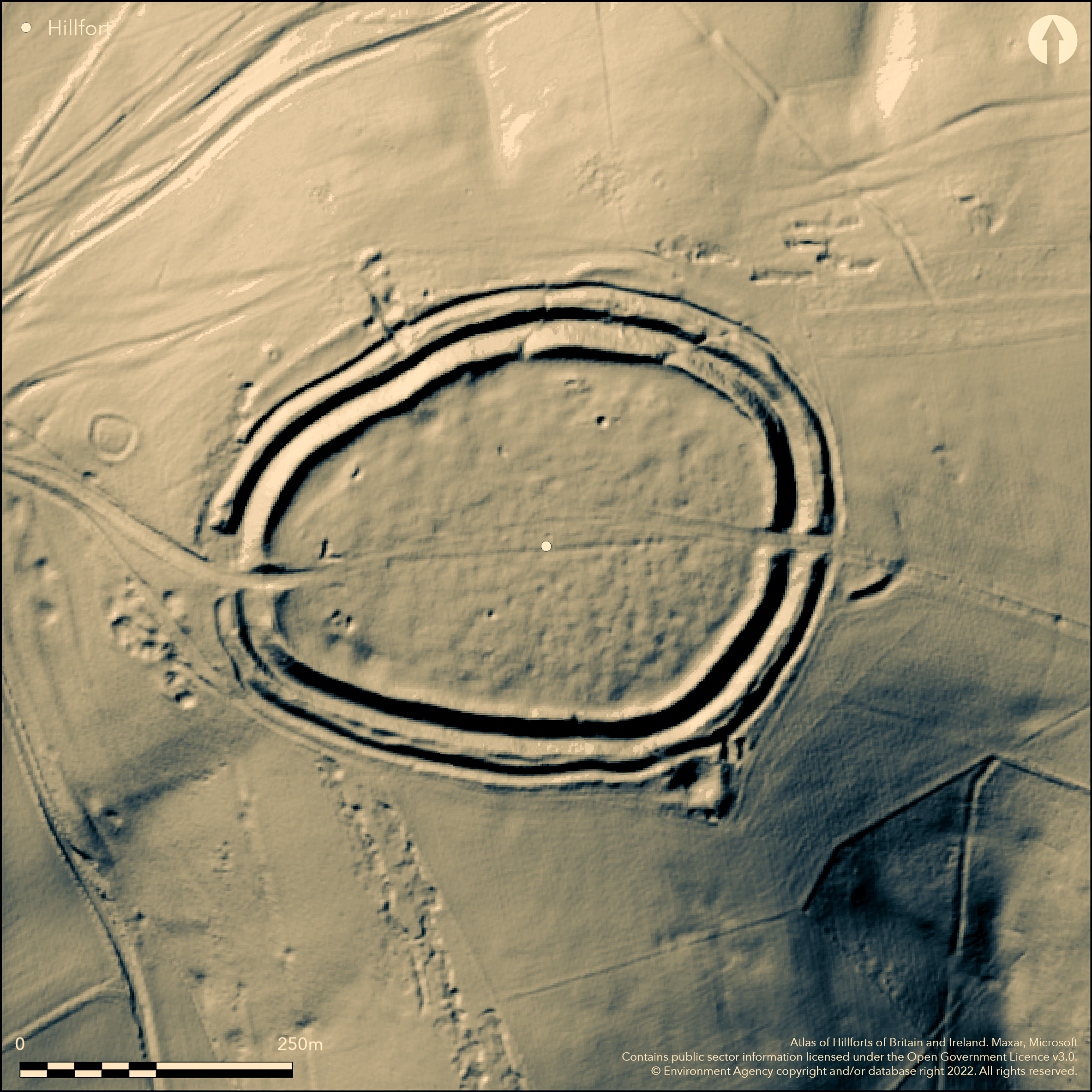
LiDAR 1m DTM Hillshade
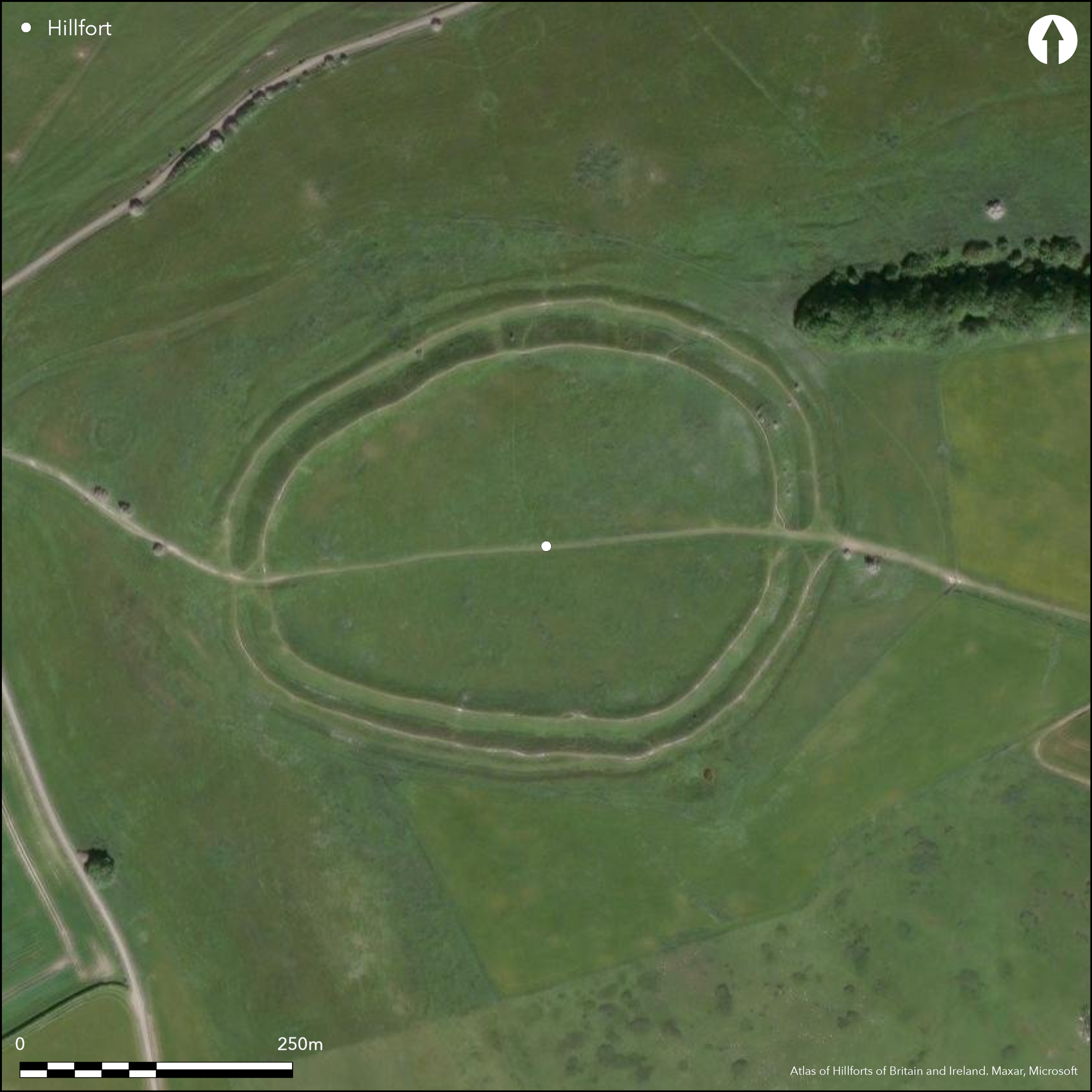
Satellite Imagery
LiDAR 1m DTM Hillshade
Satellite Imagery
Scroll left/right to view further images.
HER: Wiltshire and Swindon MWI15208 (None)
NMR: SU 17 NW 8 (221369)
SM: 1014557
NGR: SU14937628
X: 414933 Y: 176285 (OSGB36)
Fine and massive, bivallate, contour hillfort in commanding strategic position at W end of W-facing promontory on Barbury Down (Marlborough Downs) at N end of River Og valley just S of ancient Ridgeway. Opposite to Liddington Castle (Atlas No 0388). Now part of the Barbury Castle Country Park. Possibly overlies earlier hilltop enclosure. Defences of at least two phases, as outwork cut and overlain by outer rampart, with two concentric rings of banks and ditches enclosing c. 4.5ha. Inner bank c. 10m wide, with level rampart top 5m wide and up to 3m high from interior. Substantial inner ditch, constructed by digging into natural slope and building up the rampart, 24m wide and up to 10m below top of rampart. Outer rampart 15m wide with 7.5m wide top and up to 3.5m high. Outer ditch narrower at c. 10m wide and 3m deep. To N counterscarp much disturbed by quarrying. Numerous slight earthwork features in the interior with considerable sub-surface. 42 hut circles confirmed. Small early excavations only, English Heritage geophysical survey (Payne et al 2006), RCHME earthwork survey. Damaged, but generally ramparts in good condition. Iron Age and Roman surface pottery finds. So-called 'blacksmith's hoard' found in 19th century previously dated to 200-50 BC by MacGregor and Simpson (1963) now thought to be late Roman votive deposit. Anglo-Saxon finds and inhumation on site. Good upland pasture. WWII damage. On Ist Ed. OS map (1886).
Citizen Science: ✗
Reliability of Data: Confirmed
Reliability of Interpretation: Confirmed
X: -198855 Y: 6707586 (EPSG: 3857)
Longitude: -1.7863462308616394 Latitude: 51.4852721067709 (EPSG:4326)
Country: England; None
Current County or Unitary Authority: Wiltshire
Historic County: Wiltshire
Current Parish/Community/Council/Townland: Ogbourne St Andrew; Wroughton
Within Barbury Castle Country Park. WWII damage by US soldiers when W entrance widened and bombing and slit trenches in interior. Trig point on inner rampart N of E entrance. Counterscarp to N much disturbed by quarrying. Generally, however, ramparts in good condition. Post medieval dew pond on SE rampart.
| Extant | ✓ |
| Cropmark | ✗ |
| Likely Destroyed | ✗ |
Good upland pasture free of restriction. Bombing and slit trenches in interior. Trig point. Quarrying.
| Woodland | ✗ |
| Commercial Forestry Plantation | ✗ |
| Parkland | ✗ |
| Pasture (Grazing) | ✓ |
| Arable | ✗ |
| Scrub/Bracken | ✗ |
| Bare Outcrop | ✗ |
| Heather/Moorland | ✗ |
| Heath | ✗ |
| Built-up | ✗ |
| Coastal Grassland | ✗ |
| Other | ✓ |
Massive bivallate contour hillfort in fine and commanding strategic position at W end of W-facing promontory on Barbury Down (Marlborough Downs), at N end of River Og valley just S of ancient Ridgeway.
| Contour Fort | ✓ |
| Partial Contour Fort | ✗ |
| Promontory Fort | ✗ |
| Hillslope Fort | ✗ |
| Level Terrain Fort | ✗ |
| Marsh Fort | ✗ |
| Multiple Enclosure Fort | ✗ |
Located on a prominent spur of the Marlborough Downs at the northen end of the River Og valley, a major routeway, and just south of the original ancient Ridgeway route. Similar situation to Liddington Castle.
| Hilltop | ✗ |
| Coastal Promontory | ✗ |
| Inland Promontory | ✓ |
| Valley Bottom | ✗ |
| Knoll/Hillock/Outcrop | ✗ |
| Ridge | ✗ |
| Cliff/Plateau-edge/Scarp | ✗ |
| Hillslope | ✗ |
| Lowland | ✗ |
| Spur | ✗ |
Dominant Topographic Feature: W-facing downland promontory.
| North | ✗ |
| Northeast | ✗ |
| East | ✗ |
| Southeast | ✗ |
| South | ✗ |
| Southwest | ✗ |
| West | ✗ |
| Northwest | ✗ |
| Level | ✓ |
Altitude: 265.0m
Track through E-W entrances of hillfort marks parish boundary between Ogbourne St Andrew and Wroughton.
Boundary Type: Parish/Townland
Iron Age and Romano-British pottery finds. Military digging 1939-45 exposed early and middle Iron Age pottery. Possibly enclosure early to middle Iron Age to early 1st millennium AD date. Many pits suggest long period of density of occupation.
Reliability: B - Medium
| Pre 1200BC | ✗ |
| 1200BC - 800BC | ✗ |
| 800BC - 400BC | ✓ |
| 400BC - AD50 | ✓ |
| AD50 - AD400 | ✗ |
| AD400 - AD 800 | ✗ |
| Post AD800 | ✗ |
| Unknown | ✗ |
| Pre Hillfort: | None |
| Post Hillfort: | None |
| Artefactual: | Iron Age and Romano-British pottery. Military digging 1939-45 exposed early and middle Iron Age pottery. |
In Aubrey's Monumenta Britannica (1665-1693). On Ist Ed. OS map (1886). Excavation by Reverend H. Harris 1870-5. Small pit dug A.D. Passmore 1933. Military digging 1939-45. Geophysical survey for Wessex Hillforts Project 1996. An earthwork survey by the RCHME in 1998 recorded many features.
| 1st Identified Map Depiction (1886): | OS map. |
| Excavation (1933): | A.D. Passmore. |
| Geophysical Survey (1996): | Wessex Hillforts Project. |
| Earthwork Survey (1998): | RCHME measured survey (M. Bowden). |
| Other (2003): | Visited by Hillfort Study Group |
| Other (2009): | EH Barbury Castle Environs Aerial Photographic Survey and Analysis Project. |
| 1st Identified Written Reference (None): | In Aubrey's Monumenta Britannica. |
| Excavation (None): | Rev H. Harris. |
| Excavation (None): | Military digging. |
Two small excavations with no details. Geophysical survey showed considerable interior features, many probably prehistoric. Six sub-surface hut circles to add to the 35 surface identified. Former possibly earlier occupation. Few chance finds dateable to early or middle Iron Age. Military digging 1939-45 exposed early and middle Iron Age pottery. "Blacksmith's' hoard of iron tools found in 19th century previously dated to 200-50BC by MacGregor and Simpson (1963) now thought to be late Roman votive deposit.
None
| None | ✓ |
| Spring | ✗ |
| Stream | ✗ |
| Pool | ✗ |
| Flush | ✗ |
| Well | ✗ |
| Other | ✗ |
One slight mound may indicate barrow cemetery outside to W may have extended into fort. 35 hut circles to add to six from geophysical survey.
| No Known Features | ✗ |
| Round Stone Structures | ✗ |
| Rectangular Stone Structures | ✗ |
| Curvilinear Platforms | ✓ |
| Other Roundhouse Evidence | ✗ |
| Pits | ✗ |
| Quarry Hollows | ✗ |
| Other | ✓ |
Two small excavations with no details.
| No Known Excavation | ✗ |
| Pits | ✗ |
| Postholes | ✗ |
| Roundhouses | ✗ |
| Rectangular Structures | ✗ |
| Roads/Tracks | ✗ |
| Quarry Hollows | ✗ |
| Other | ✗ |
| Nothing Found | ✓ |
Wessex Hillforts Project survey found considerable interior features, many probably prehistoric. Six sub-surface hut circles to add to the 35 surface identified. Former possibly earlier occupation. Many pits suggesting long period of occupation.
| No Known Geophysics | ✗ |
| Pits | ✓ |
| Roundhouses | ✓ |
| Rectangular Structures | ✗ |
| Roads/Tracks | ✗ |
| Quarry Hollows | ✗ |
| Other | ✗ |
| Nothing Found | ✗ |
Military digging 1939-45 exposed early and middle Iron Age pottery. Few chance finds dateable to early or middle Iron Age. So-called 'Blacksmith's hoard' found in 19th century previously dated to 200-50 BC by MacGregor and Simpson (1963) now thought to be late Roman votive deposit.
| No Known Finds | ✗ |
| Pottery | ✓ |
| Metal | ✓ |
| Metalworking | ✗ |
| Human Bones | ✗ |
| Animal Bones | ✗ |
| Lithics | ✗ |
| Environmental | ✗ |
| Other | ✗ |
None
| APs Not Checked | ✓ |
| None | ✗ |
| Roundhouses | ✗ |
| Rectangular Structures | ✗ |
| Pits | ✗ |
| Postholes | ✗ |
| Roads/Tracks | ✗ |
| Other | ✗ |
Two original entrances, situated to the E and W of the enclosure. The entrances both measure c. 10m wide and cross natural causeways left when ditches built. The E entrance defended by right-angled outwork extending out from main earthworks. This measures c. 7m wide and has become infilled due to cultivation over past 100 years. The forework outside the E entrance sits at an angle to main ramparts and has been cut by the outer ditch, suggesting it could have been re-used as an outwork.
| 2: | Two entrances form public access. |
| 2: | Two original entrances, situated to the E and W. |
Guard Chambers: ✗
Chevaux de Frise: ✗
| 1. Outworks (East): | Significant outwork with causeway across ditch. |
| 2. Passage-way/Corridor (West): | Passage through ramparts with causeway across ditch. |
Defences are of at least two phases, as outwork cut and overlain by outer rampart, with two concentric rings of banks and ditches enclosing c. 4.5ha. Inner bank c. 10m wide with level rampart top 5m wide and up to 3m high from interior. Substantial inner ditch, constructed by digging into natural slope and building up rampart, 24m wide and up to 10m below top of rampart. Outer rampart 15m wide with 7.5m wide top and up to 3.5m high. Outer ditch narrower at c. 10m wide and 3m deep. To N counterscarp much disturbed by quarrying.
| Area 1: | 4.5ha. |
| Total: | 4.5ha. |
Total Footprint Area: Noneha.
None
| ✓ | Defences of at least two phases, as outwork cut and overlain by outer rampart, with two concentric rings of banks and ditches enclosing. |
| ✓ | None |
| NE Quadrant: | 2 |
| SE Quadrant: | 2 |
| SW Quadrant: | 2 |
| NW Quadrant: | 2 |
| Total: | 2 |
| Partial Univallate | ✗ |
| Univallate | ✗ |
| Partial Bivallate | ✗ |
| Bivallate | ✓ |
| Partial Multivallate | ✗ |
| Multivallate | ✗ |
| Unknown | ✗ |
| Partial Univallate | ✗ |
| Univallate | ✓ |
| Partial Bivallate | ✗ |
| Bivallate | ✗ |
| Partial Multivallate | ✗ |
| Multivallate | ✗ |
Possible earthen and rubble bank. To N counterscarp much disturbed by quarrying.
| None | ✗ |
| Earthen Bank | ✓ |
| Stone Wall | ✗ |
| Rubble | ✓ |
| Wall-walk | ✗ |
| Evidence of Timber | ✗ |
| Vitrification | ✗ |
| Other Burning | ✗ |
| Palisade | ✗ |
| Counter Scarp Bank | ✓ |
| Berm | ✗ |
| Unfinished | ✗ |
| Other | ✗ |
None
| None | ✗ |
| Earthen Bank | ✗ |
| Stone Wall | ✗ |
| Murus Duplex | ✗ |
| Timber-framed | ✗ |
| Timber-laced | ✗ |
| Vitrification | ✗ |
| Other Burning | ✗ |
| Palisade | ✗ |
| Counter Scarp Bank | ✗ |
| Berm | ✗ |
| Unfinished | ✗ |
| No Known Excavation | ✓ |
| Other | ✗ |
| ✗ | None |
| ✓ | Concentric ring of ditches. Inner substantial, outer narrower. |
Number of Ditches: 2
| ✗ | None |
Bowden M. 2005. The middle Iron Age on the Marlborough Downs, in eds G. Brown, D. Field and D. McOmish, The Avebury landscape, Oxford: Oxbow Books, 156-63.
McQueen, M. 2009. Barbury Castle Environs: air photo survey and analysis: special project report, Archaeology Report No 81-2009.
MacGregor, M. and and Simpson, D.D.A. 1963. A group of iron objects from Barbury Castle, Wilts, Wiltshire Archaeol Natur Hist Mag, 58, 394-402.
Payne, A., Corney, M. and Cunliffe, B. 2006. The Wessex Hillforts Project. Extensive survey of hillfort interiors in Cenral Southern England, London: English Heritage, 98-103.
Pugh, R.B. and Crittall, E. 1957. A history of Wiltshire, 1.1, The Victoria History of the Counties of England, London: OUP, 94, 268.
Atlas of Hillforts:
Wikidata:
This work is licensed under CC BY-SA 4.0

 and should be cited as:
Lock, Gary and Ralston, Ian. 2024. Atlas of Hillforts of Britain and Ireland. Available at: https://hillforts.arch.ox.ac.uk
Document Version 1.1