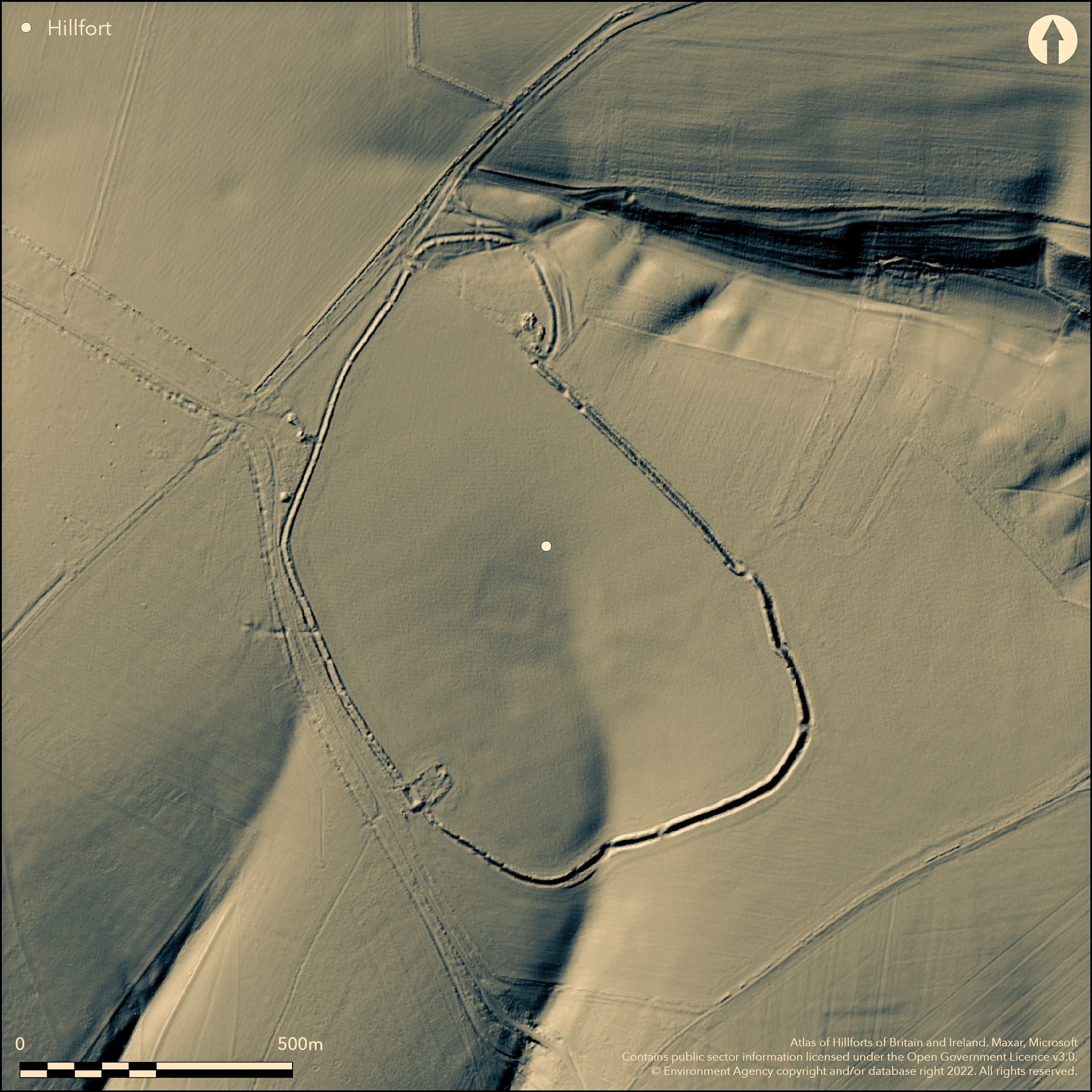
LiDAR 1m DTM Hillshade
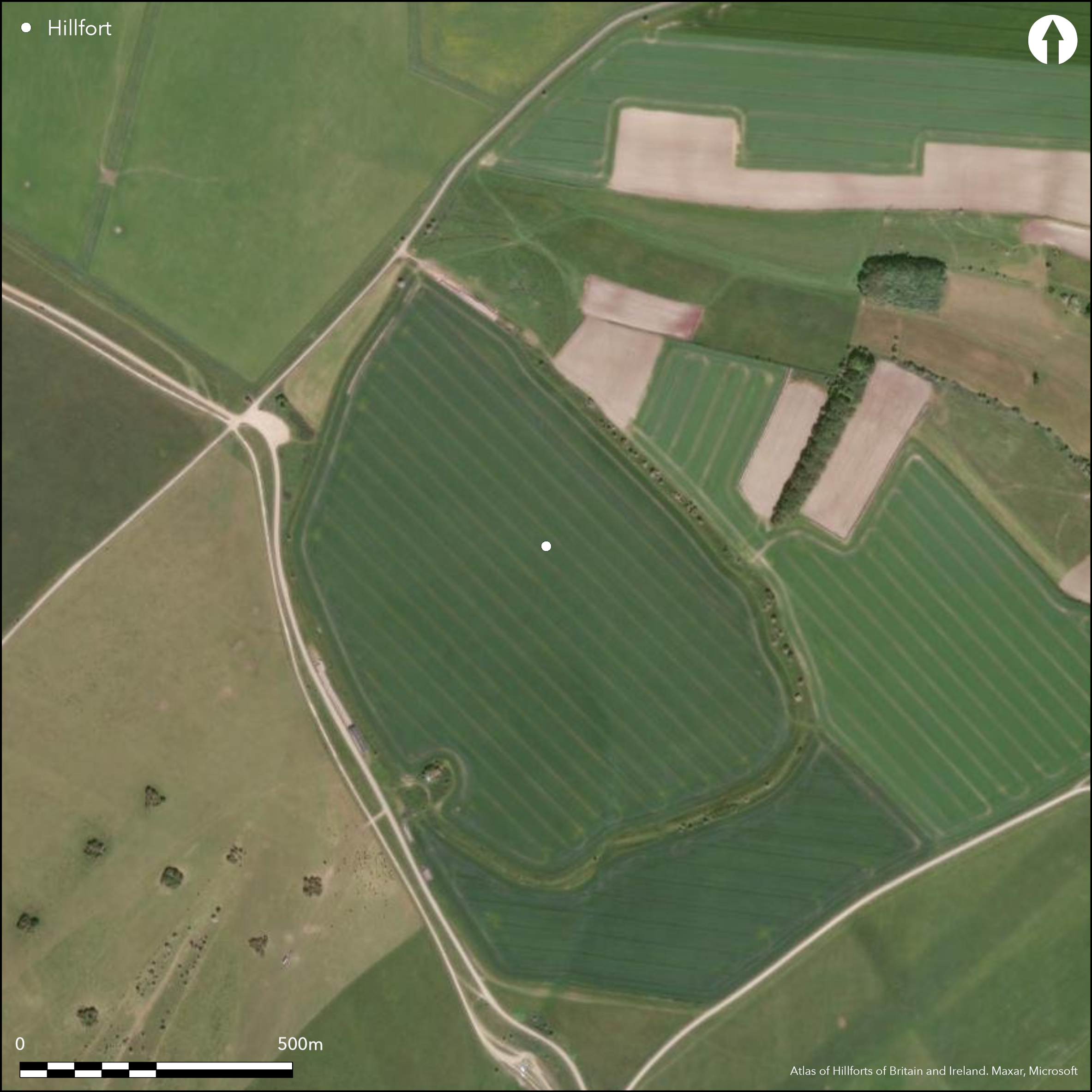
Satellite Imagery
LiDAR 1m DTM Hillshade
Satellite Imagery
Scroll left/right to view further images.
HER: Wiltshire and Swindon MWI13888 (None)
NMR: SU 15 SW 5 (220402)
SM: 1010074
NGR: SU11585356
X: 411584 Y: 153560 (OSGB36)
Very large partial contour univallate hillfort of 27.5 ha located on level plateau on NE edge of the Plain overlooking valley of the River Avon. Poor defensive position exacerbated by enclosure sweeping down into shallow combe to S, where the entrance is sited with spring nearby. Sits on junction of linear boundaries - at least three from W and another to S from the entrance. Largest hillfort in Ministry of Defence Salisbury Training Area. Seems incomplete, with lengths of bank and ditch separated by gaps c. 1m wide. Internally there are two complex irregular enclosures and ditches, and possible Viereckschanze (later prehistoric/Romano British ritual enclosure) in the centre of the site, all now obliterated by ploughing. Site boundary follows contours, except on NE side where semi-circular annexe includes upper end of a coombe. Similarly, along S side hillfort defences dip to accommodate a steep hollow. Single bank and external ditch, best preserved on E and S sides, where rampart reaches 2.5m-3m above ditch bottom, 2m-3.5m in width up to 1.5m deep. Defences on W side less substantial and suggestions made that unfinished. However damage here possibly agricultural or result of three trackways on Andrews and Dury's map of 1773. Annexe defined by single bank 3m-4m wide and to 1.5m high, with ditch 1-2m wide and 0.5m deep, both damaged. Within its interior, number of platforms, terraces and linear features perhaps later. However, circular platform c. 4m diameter partially enclosed by bank 1m wide and c. 0.3m high, may be original. Linear ditched features (trackways/holloways), contiguous with annexe, and 50m to NE remains of field system. Unusual shape of annexe problematical, possibly part of an original oval enclosure, but as not complete circuit from air questionable and annexe possibly contemporary with rest of hillfort. Three gaps in circuit, one original, the others corresponding with two of trackways depicted in Andrews and Dury's map 1773. Excavation by Cunnington and Cunnington (1913) confirmed that the ditch was continuous at both points. Middle to late Iron Age pottery found. Cunningtons' excavations referred to pits excavated as 'pit dwellings'. Also T-shaped 'hypercaust' hearths on side of ditch. Downland pasture. Stable but damaged condition. On 1st Ed. OS map (1887).
Citizen Science: ✗
Reliability of Data: Confirmed
Reliability of Interpretation: Confirmed
X: -204306 Y: 6671153 (EPSG: 3857)
Longitude: -1.835312684634963 Latitude: 51.28101156005919 (EPSG:4326)
Country: England
Current County or Unitary Authority: Wiltshire
Historic County: Wiltshire
Current Parish/Community/Council/Townland: Upavon
Damaged, but stable condition. Interior features obliterated by past ploughing. On Heritage at Risk Register (2015).
| Extant | ✓ |
| Cropmark | ✗ |
| Likely Destroyed | ✗ |
Downland pasture.
| Woodland | ✗ |
| Commercial Forestry Plantation | ✗ |
| Parkland | ✗ |
| Pasture (Grazing) | ✓ |
| Arable | ✗ |
| Scrub/Bracken | ✗ |
| Bare Outcrop | ✗ |
| Heather/Moorland | ✗ |
| Heath | ✗ |
| Built-up | ✗ |
| Coastal Grassland | ✗ |
| Other | ✗ |
Large univallate hillfort located on level plateau on NE edge of the Plain overlooking valley of the River Avon. Poor defensive position exacerbated by the enclosure sweeping down into a shallow coombe to S where the entrance is sited with spring nearby.
| Contour Fort | ✗ |
| Partial Contour Fort | ✓ |
| Promontory Fort | ✗ |
| Hillslope Fort | ✗ |
| Level Terrain Fort | ✗ |
| Marsh Fort | ✗ |
| Multiple Enclosure Fort | ✗ |
Located on a level plateau on the north-eastern edge of the massif overlooking the valley of the River Avon. Poor defensive position exacerbated by the enclosure sweeping down into a shallow coombe to the south where the entrance is sited with spring nearby. Sits on the junction of linear boundaries - at least three from the west and another to the south from the entrance. In the Ministry of Defence Salisbury Training Area.
| Hilltop | ✗ |
| Coastal Promontory | ✗ |
| Inland Promontory | ✗ |
| Valley Bottom | ✗ |
| Knoll/Hillock/Outcrop | ✗ |
| Ridge | ✗ |
| Cliff/Plateau-edge/Scarp | ✓ |
| Hillslope | ✗ |
| Lowland | ✗ |
| Spur | ✗ |
Dominant Topographic Feature: Level plateau
| North | ✗ |
| Northeast | ✗ |
| East | ✗ |
| Southeast | ✗ |
| South | ✗ |
| Southwest | ✗ |
| West | ✗ |
| Northwest | ✓ |
| Level | ✗ |
Altitude: 168.0m
N/A
Middle to late Iron Age 'bead-rim' pottery from excavation.
Reliability: B - Medium
| Pre 1200BC | ✗ |
| 1200BC - 800BC | ✗ |
| 800BC - 400BC | ✗ |
| 400BC - AD50 | ✓ |
| AD50 - AD400 | ✗ |
| AD400 - AD 800 | ✗ |
| Post AD800 | ✗ |
| Unknown | ✗ |
| Pre Hillfort: | None |
| Post Hillfort: | None |
| Artefactual: | Middle to late Iron Age 'bead-rim' pottery. |
In Aubrey's Monumenta Britannica (1665-1693). Andrews and Dury's Topographical Map of Wiltshire 1773. On Ist Ed. OS map (1887). Planned by Colt Hoare early 19th century. Excavation by B.H. Cunnington and M.E. Cunnington 1909-12. RCHME measured survey, ref. no. 888341: Salisbury Plain MOD Training Area, undated.
| 1st Identified Map Depiction (1773): | Andrews and Dury's Topographical Map of Wiltshire. |
| Other (1810): | Planned by R.C. Colt Hoare. |
| Other (1887): | OS map |
| Other (1924): | Aerial photographs by O.G.S. Crawford and A. Keiller. |
| 1st Identified Written Reference (None): | In Aubrey's Monumenta Britannica. |
| Excavation (None): | B.H. Cunnington and M.E. Cunnington. |
| Other (None): | RCHME measured survey: Salisbury Plain MOD Training Area. |
Pits. Middle to late Iron Age 'bead-rim' pottery. Human remains, including skulls. Spindle whorls and loom weights, quern pieces, slingstones, hammerstones and oyster shells. Iron objects, including tools. Roman coins from Claudius I (AD 41-54) to Constantine II (AD 317-337) and other Roman items, including Samian ware fragment. Late Bronze Age metalwork, including palstave and bronze stud found in immediate vicinity of hillfort.
Enclosure sweeps down into shallow combe on S where entrance sited with spring nearby. Unusual plan of site seems to favour stock control downslope to spring.
| None | ✓ |
| Spring | ✗ |
| Stream | ✗ |
| Pool | ✗ |
| Flush | ✗ |
| Well | ✗ |
| Other | ✗ |
Early Iron Age pits.
| No Known Features | ✗ |
| Round Stone Structures | ✗ |
| Rectangular Stone Structures | ✗ |
| Curvilinear Platforms | ✗ |
| Other Roundhouse Evidence | ✗ |
| Pits | ✓ |
| Quarry Hollows | ✗ |
| Other | ✗ |
Cunningtons' excavations referred to pits excavated as 'pit dwellings'. Also T-shaped 'hypercaust' hearths on side of ditch.
| No Known Excavation | ✗ |
| Pits | ✓ |
| Postholes | ✗ |
| Roundhouses | ✗ |
| Rectangular Structures | ✗ |
| Roads/Tracks | ✗ |
| Quarry Hollows | ✗ |
| Other | ✓ |
| Nothing Found | ✗ |
None
| No Known Geophysics | ✓ |
| Pits | ✗ |
| Roundhouses | ✗ |
| Rectangular Structures | ✗ |
| Roads/Tracks | ✗ |
| Quarry Hollows | ✗ |
| Other | ✗ |
| Nothing Found | ✗ |
Middle to late Iron Age 'bead-rim' pottery. Human remains, including skulls. Spindle whorls and loom weights, quern pieces, slingstones, hammerstones and oyster shells. Iron objects, including tools. `Roman coins from Claudius I (AD 41-54) to Constantine II (AD 317-337) and other Roman items, including Samian ware fragment. Late Bronze Age metalwork, including palstave and bronze stud found in immediate vicinity of hillfort.
| No Known Finds | ✗ |
| Pottery | ✓ |
| Metal | ✓ |
| Metalworking | ✗ |
| Human Bones | ✓ |
| Animal Bones | ✗ |
| Lithics | ✓ |
| Environmental | ✓ |
| Other | ✗ |
None
| APs Not Checked | ✓ |
| None | ✗ |
| Roundhouses | ✗ |
| Rectangular Structures | ✗ |
| Pits | ✗ |
| Postholes | ✗ |
| Roads/Tracks | ✗ |
| Other | ✗ |
Gaps in circuit on N, S, E, W, that to S thought original. Of two of the trackways depicted on Andrews and Dury's map 1773, excavation by Cunnington confirmed that the ditch was continuous at both points.
| 7: | Gaps to N, S, E and W. |
| 2: | Entrance to S downslope into a shallow combe original. |
Guard Chambers: ✗
Chevaux de Frise: ✗
| 1. Simple Gap (South): | None |
Site boundary follows contours, except on NE side where semi-circular annexe includes upper end of a combe. Similarly, along the S side, hillfort defences dip to accommodate a steep hollow. Single bank and external ditch, best preserved on E and S sides, where rampart reaches 2.5m-3m above ditch bottom, -3.5m in width up to 1.5m deep. Defences on W side less substantial and suggestions made that unfinished. However damage here possibly agricultural or result of three trackways on Andrews and Dury's map of 1773.
| Area 1: | 27.5ha. |
| Total: | 27.5ha. |
Total Footprint Area: Noneha.
None
| ✗ | None |
| ✓ | None |
| NE Quadrant: | 1 |
| SE Quadrant: | 1 |
| SW Quadrant: | 1 |
| NW Quadrant: | 1 |
| Total: | 1 |
| Partial Univallate | ✗ |
| Univallate | ✓ |
| Partial Bivallate | ✗ |
| Bivallate | ✗ |
| Partial Multivallate | ✗ |
| Multivallate | ✗ |
| Unknown | ✗ |
| Partial Univallate | ✗ |
| Univallate | ✗ |
| Partial Bivallate | ✗ |
| Bivallate | ✗ |
| Partial Multivallate | ✗ |
| Multivallate | ✗ |
Site seems incomplete, with lengths of bank and ditch separated by gaps c. 1m wide.
| None | ✗ |
| Earthen Bank | ✗ |
| Stone Wall | ✗ |
| Rubble | ✗ |
| Wall-walk | ✗ |
| Evidence of Timber | ✗ |
| Vitrification | ✗ |
| Other Burning | ✗ |
| Palisade | ✗ |
| Counter Scarp Bank | ✗ |
| Berm | ✗ |
| Unfinished | ✓ |
| Other | ✗ |
None
| None | ✗ |
| Earthen Bank | ✓ |
| Stone Wall | ✓ |
| Murus Duplex | ✗ |
| Timber-framed | ✗ |
| Timber-laced | ✗ |
| Vitrification | ✗ |
| Other Burning | ✗ |
| Palisade | ✗ |
| Counter Scarp Bank | ✗ |
| Berm | ✗ |
| Unfinished | ✗ |
| No Known Excavation | ✗ |
| Other | ✗ |
| ✗ | None |
| ✓ | None |
Number of Ditches: 1
| ✓ | Site boundary follows contours, except on NE side where semi-circular annexe includes upper end of a coombe. |
Colt Hoare, R.C. 1810. The Ancient History of Wiltshire, 1, London: Miller.
Cunnington, B. H. and Cunnington, M.E. 1913. Casterley Camp excavations, Wiltshire Archaeol Natur Hist Mag, 38, 53-105.
Feacham, R.W. 1971. Unfinished hillforts, in eds Hill, D. and Jesson, M., The Iron Age and its hillforts, Southampton: Millbrook Press, 19-40.
McOmish, D., Field, D. and Brown, G. 2002: The Field Archaeology of the Salisbury Plain Training Area. London: HMSO
Pugh, R.B. and Crittall, E. 1957. A history of Wiltshire, 1.1, The Victoria History of the Counties of England, London: OUP, 115, 270.
Atlas of Hillforts:
Wikidata:
This work is licensed under CC BY-SA 4.0![]()
![]()
![]() and should be cited as:
and should be cited as:
Lock, Gary and Ralston, Ian. 2024. Atlas of Hillforts of Britain and Ireland. Available at: https://hillforts.arch.ox.ac.uk
Document Version 1.1