LiDAR 1m DTM Hillshade
Satellite Imagery
LiDAR 1m DTM Hillshade
Satellite Imagery
Scroll left/right to view further images.
HER: Wiltshire and Swindon MWI7285 (None)
NMR: SU 05 NE 14 (215210)
SM: None
NGR: SU09275554
X: 409274 Y: 155543 (OSGB36)
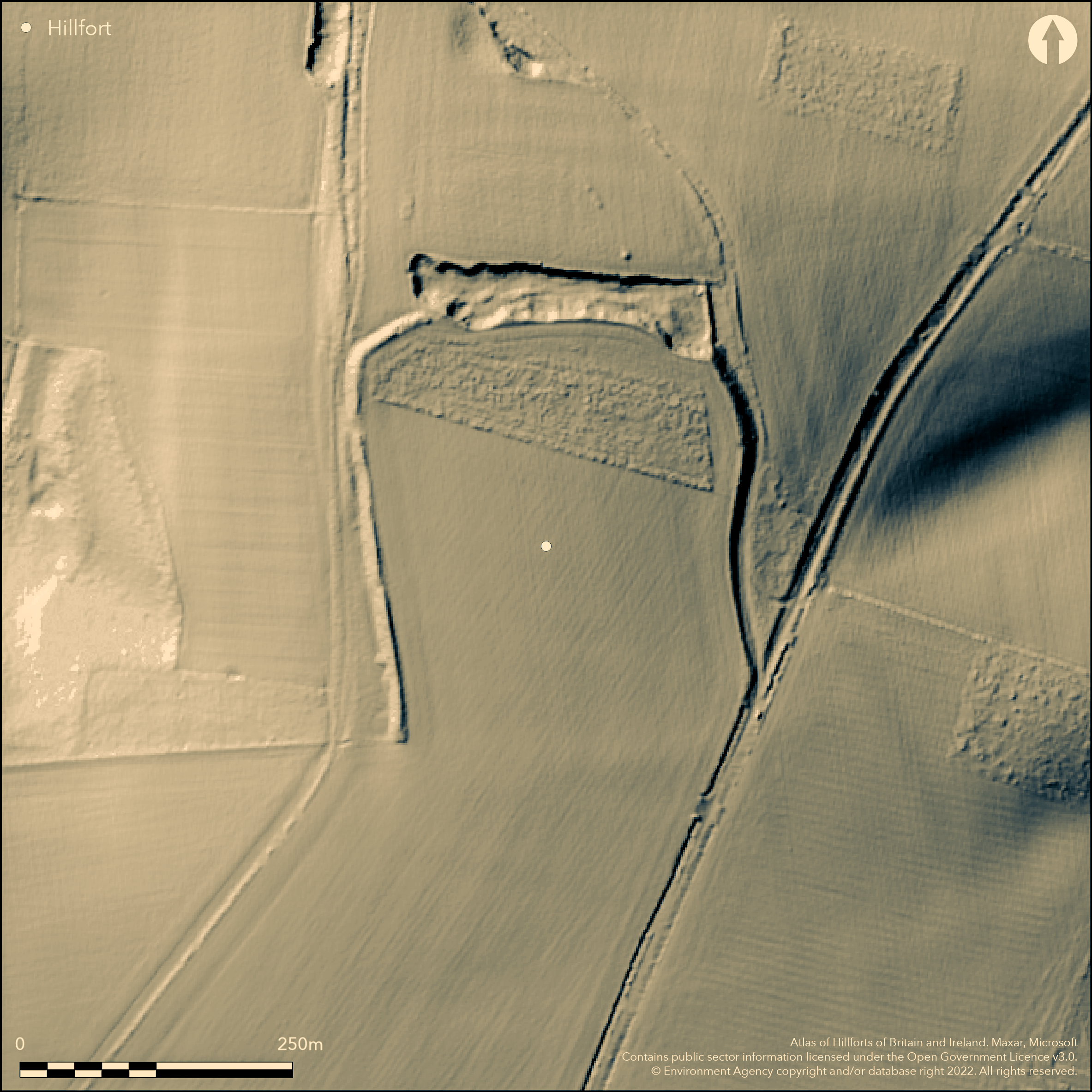
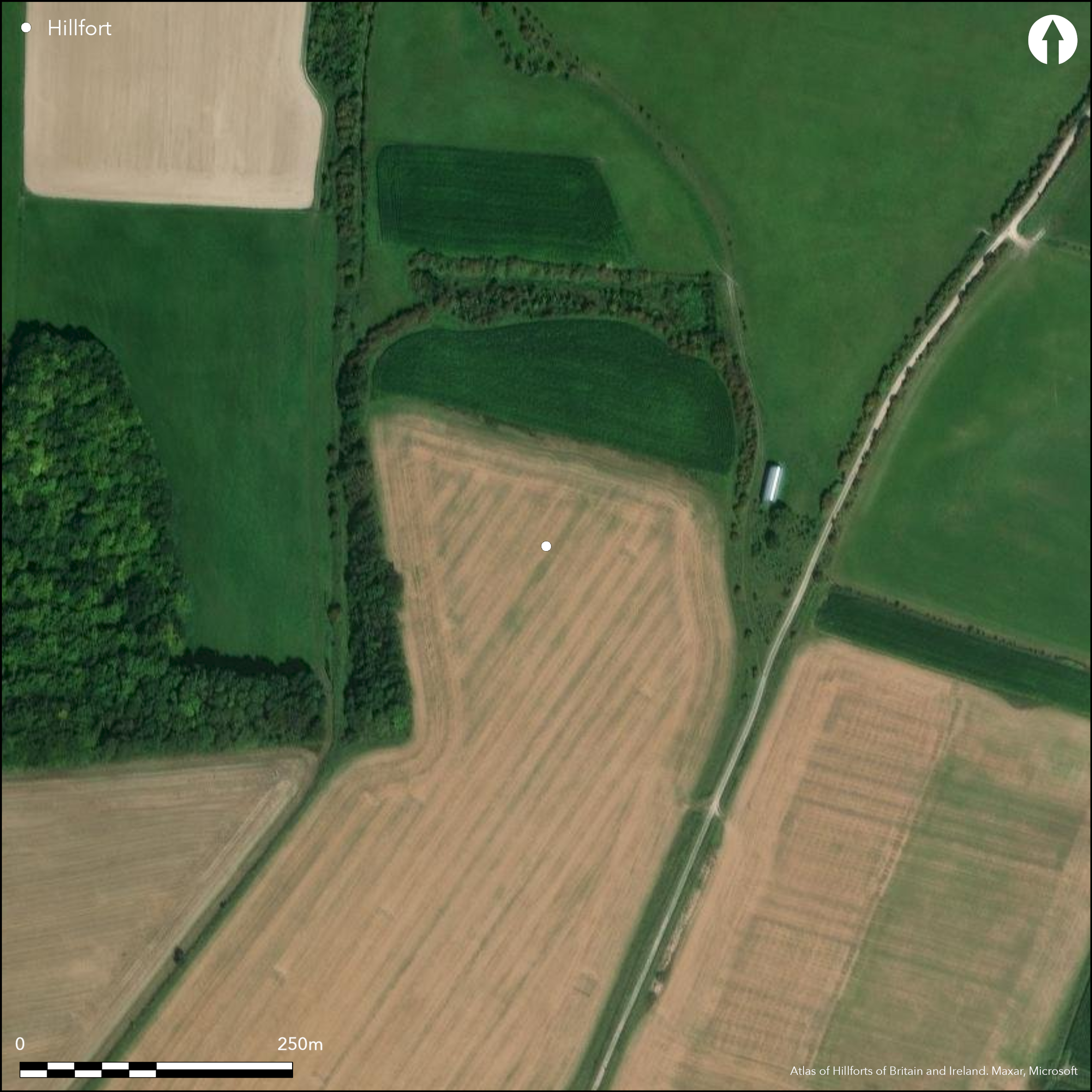
Hillslope enclosure situated on N-facing slope on Wilsford Hill, overlooking the Vale of Pewsey. Thought to be an Iron Age enclosure or hillfort never completed, or slighted, but remains also suggested as medieval or post-medieval hollow way/quarries leading from downs edge to Vale of Pewsey (McOmish et al 2002, 81). W side best preserved with inner bank 8m wide, 1.2m high and external ditch 4m wide and up to 0.4m deep which has an outer bank, 4m wide, and 5m high. The ditch and outer bank are fragmentary. N and E defined by simple scarp, increasing in height from 2m to a maximum 5m at the NE corner, suggesting c. 5ha enclosed. Excavation 1800-10 by W. Cunnington Sen. with no evidence of occupation. Old chalk quarry at N end. If site was enclosure no traces on the ground or on aerial photographs of S side. No entrance gaps visible in existing earthworks. Interior has been in arable cultivation. No interior features recorded as cropmarks on aerial photographs. Two dark marks in centre of enclosure, recorded on 1945 aerial photographs, may be relatively modern. On Ist Ed. OS map (1886-87).
Citizen Science: ✗
Reliability of Data: Confirmed
Reliability of Interpretation: Unconfirmed
X: -207987 Y: 6674334 (EPSG: 3857)
Longitude: -1.868382046287325 Latitude: 51.29888449624888 (EPSG:4326)
Country: England
Current County or Unitary Authority: Wiltshire
Historic County: Wiltshire
Current Parish/Community/Council/Townland: Wilsford
Any interior features lost to plough. Old chalk quarry at N end.
| Extant | ✓ |
| Cropmark | ✗ |
| Likely Destroyed | ✓ |
Cultivated. Quarry.
| Woodland | ✗ |
| Commercial Forestry Plantation | ✗ |
| Parkland | ✗ |
| Pasture (Grazing) | ✗ |
| Arable | ✓ |
| Scrub/Bracken | ✗ |
| Bare Outcrop | ✗ |
| Heather/Moorland | ✗ |
| Heath | ✗ |
| Built-up | ✗ |
| Coastal Grassland | ✗ |
| Other | ✓ |
Hillslope enclosure situated on N-facing slope on Wilsford Hill, overlooking the Vale of Pewsey.
| Contour Fort | ✗ |
| Partial Contour Fort | ✗ |
| Promontory Fort | ✗ |
| Hillslope Fort | ✓ |
| Level Terrain Fort | ✗ |
| Marsh Fort | ✗ |
| Multiple Enclosure Fort | ✗ |
Sited on the northern escarpment edge of Wilsford Hill within the Salisbury Plain Training Area.
| Hilltop | ✗ |
| Coastal Promontory | ✗ |
| Inland Promontory | ✗ |
| Valley Bottom | ✗ |
| Knoll/Hillock/Outcrop | ✗ |
| Ridge | ✗ |
| Cliff/Plateau-edge/Scarp | ✗ |
| Hillslope | ✓ |
| Lowland | ✗ |
| Spur | ✗ |
Dominant Topographic Feature: N-facing slope on Wilsford Hill.
| North | ✓ |
| Northeast | ✗ |
| East | ✗ |
| Southeast | ✗ |
| South | ✗ |
| Southwest | ✗ |
| West | ✗ |
| Northwest | ✗ |
| Level | ✗ |
Altitude: 180.0m
N/A
None
Reliability: D - None
| Pre 1200BC | ✗ |
| 1200BC - 800BC | ✗ |
| 800BC - 400BC | ✗ |
| 400BC - AD50 | ✗ |
| AD50 - AD400 | ✗ |
| AD400 - AD 800 | ✗ |
| Post AD800 | ✗ |
| Unknown | ✓ |
| Pre Hillfort: | None |
| Post Hillfort: | None |
On Ist Ed. OS map (1886-87). Excavation 1800-10 by W. Cunnington Sen. with no evidence of occupation. English Heritage survey and investigation as part of Marden Environs NMP 2008-09.
| Excavation (None): | W. Cunnington Sen. |
| 1st Identified Map Depiction (None): | OS map. |
| Other (None): | Hatfield Earthworks, Marden, Wiltshire, EH survey and investigation. |
Site regularly photographed since 1940's showing no interior features. Two dark marks in centre of enclosure, recorded on 1945 aerial photographs, may be relatively modern. Excavation 1800-10 by W. Cunnington Sen. with no evidence of occupation.
None
| None | ✓ |
| Spring | ✗ |
| Stream | ✗ |
| Pool | ✗ |
| Flush | ✗ |
| Well | ✗ |
| Other | ✗ |
None
| No Known Features | ✓ |
| Round Stone Structures | ✗ |
| Rectangular Stone Structures | ✗ |
| Curvilinear Platforms | ✗ |
| Other Roundhouse Evidence | ✗ |
| Pits | ✗ |
| Quarry Hollows | ✗ |
| Other | ✗ |
Excavation 1800-10 by W. Cunnington Sen. with no evidence of occupation.
| No Known Excavation | ✗ |
| Pits | ✗ |
| Postholes | ✗ |
| Roundhouses | ✗ |
| Rectangular Structures | ✗ |
| Roads/Tracks | ✗ |
| Quarry Hollows | ✗ |
| Other | ✗ |
| Nothing Found | ✓ |
None
| No Known Geophysics | ✓ |
| Pits | ✗ |
| Roundhouses | ✗ |
| Rectangular Structures | ✗ |
| Roads/Tracks | ✗ |
| Quarry Hollows | ✗ |
| Other | ✗ |
| Nothing Found | ✗ |
None
| No Known Finds | ✓ |
| Pottery | ✗ |
| Metal | ✗ |
| Metalworking | ✗ |
| Human Bones | ✗ |
| Animal Bones | ✗ |
| Lithics | ✗ |
| Environmental | ✗ |
| Other | ✗ |
Site regularly photographed since 1940's showing no interior featureas. Two dark marks in centre of enclosure, recorded on 1945 aerial photographs, may be relatively modern.
| APs Not Checked | ✗ |
| None | ✓ |
| Roundhouses | ✗ |
| Rectangular Structures | ✗ |
| Pits | ✗ |
| Postholes | ✗ |
| Roads/Tracks | ✗ |
| Other | ✗ |
No entrance gaps visible in existing earthworks.
| 0: | None |
| 2: | None |
Guard Chambers: ✗
Chevaux de Frise: ✗
W side best preserved with inner bank 8m wide, 1.2m high and external ditch 4m wide and up to 0.4m deep which has an outer bank, 4m wide, and 5m high. The ditch and outer bank are fragmentary. North and East defined by simple scarp, increasing in height from 2m to a maximum 5m at the NE corner. No traces on the ground or on aerial photographs of S side.
| Area 1: | 5.0ha. |
| Total: | 5.0ha. |
Total Footprint Area: Noneha.
None
| ✗ | None |
| ✗ | No traces on the ground or on aerial photographs of S side. |
| NE Quadrant: | 1 |
| SE Quadrant: | 0 |
| SW Quadrant: | 2 |
| NW Quadrant: | 2 |
| Total: | 2 |
| Partial Univallate | ✓ |
| Univallate | ✗ |
| Partial Bivallate | ✓ |
| Bivallate | ✗ |
| Partial Multivallate | ✗ |
| Multivallate | ✗ |
| Unknown | ✗ |
| Partial Univallate | ✗ |
| Univallate | ✗ |
| Partial Bivallate | ✗ |
| Bivallate | ✗ |
| Partial Multivallate | ✗ |
| Multivallate | ✗ |
None
| None | ✗ |
| Earthen Bank | ✓ |
| Stone Wall | ✗ |
| Rubble | ✗ |
| Wall-walk | ✗ |
| Evidence of Timber | ✗ |
| Vitrification | ✗ |
| Other Burning | ✗ |
| Palisade | ✗ |
| Counter Scarp Bank | ✗ |
| Berm | ✗ |
| Unfinished | ✗ |
| Other | ✗ |
None
| None | ✗ |
| Earthen Bank | ✗ |
| Stone Wall | ✗ |
| Murus Duplex | ✗ |
| Timber-framed | ✗ |
| Timber-laced | ✗ |
| Vitrification | ✗ |
| Other Burning | ✗ |
| Palisade | ✗ |
| Counter Scarp Bank | ✗ |
| Berm | ✗ |
| Unfinished | ✗ |
| No Known Excavation | ✓ |
| Other | ✗ |
| ✗ | None |
| ✓ | None |
Number of Ditches: 1
| ✗ | None |
Field, D., Martin, L. and Winton, H. 2009. The Hatfield Earthworks, Marden, Wiltshire: survey and investigation, Centre for Archaeology Report No 96-2009.
Hoare, R.C. 1812. Ancient Wiltshire South, 177.
McOmish, D., Field, D. and Brown, G. 2002. The Field Archaeology of Salisbury Plain Training Area, Swindon: English Heritage, 81.
Pugh, R.B. and Crittall, E. 1957. A history of Wiltshire, 1.1, The Victoria History of the Counties of England, London: OUP, 270.
Atlas of Hillforts:
Wikidata:
This work is licensed under CC BY-SA 4.0![]()
![]()
![]() and should be cited as:
and should be cited as:
Lock, Gary and Ralston, Ian. 2024. Atlas of Hillforts of Britain and Ireland. Available at: https://hillforts.arch.ox.ac.uk
Document Version 1.1