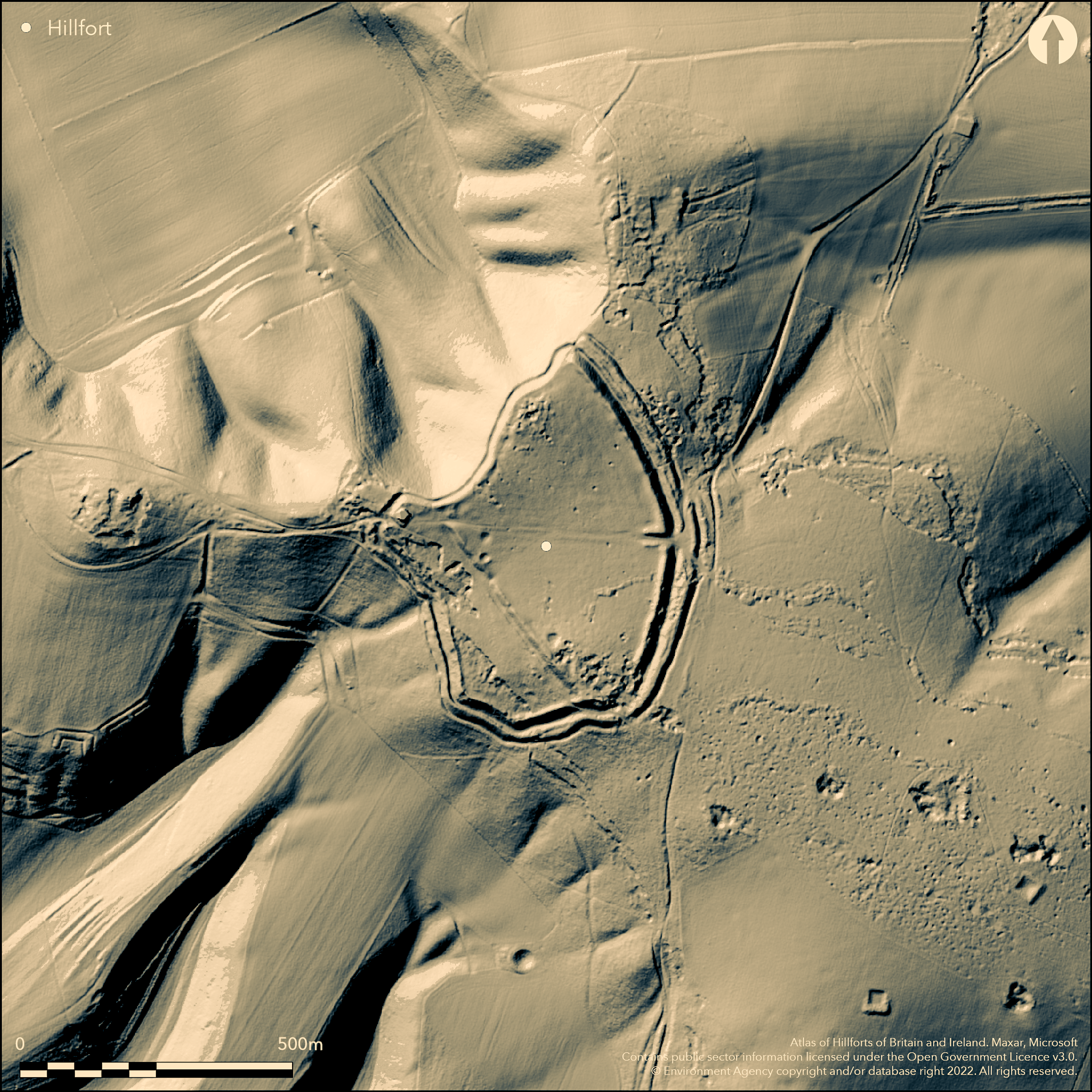
LiDAR 1m DTM Hillshade
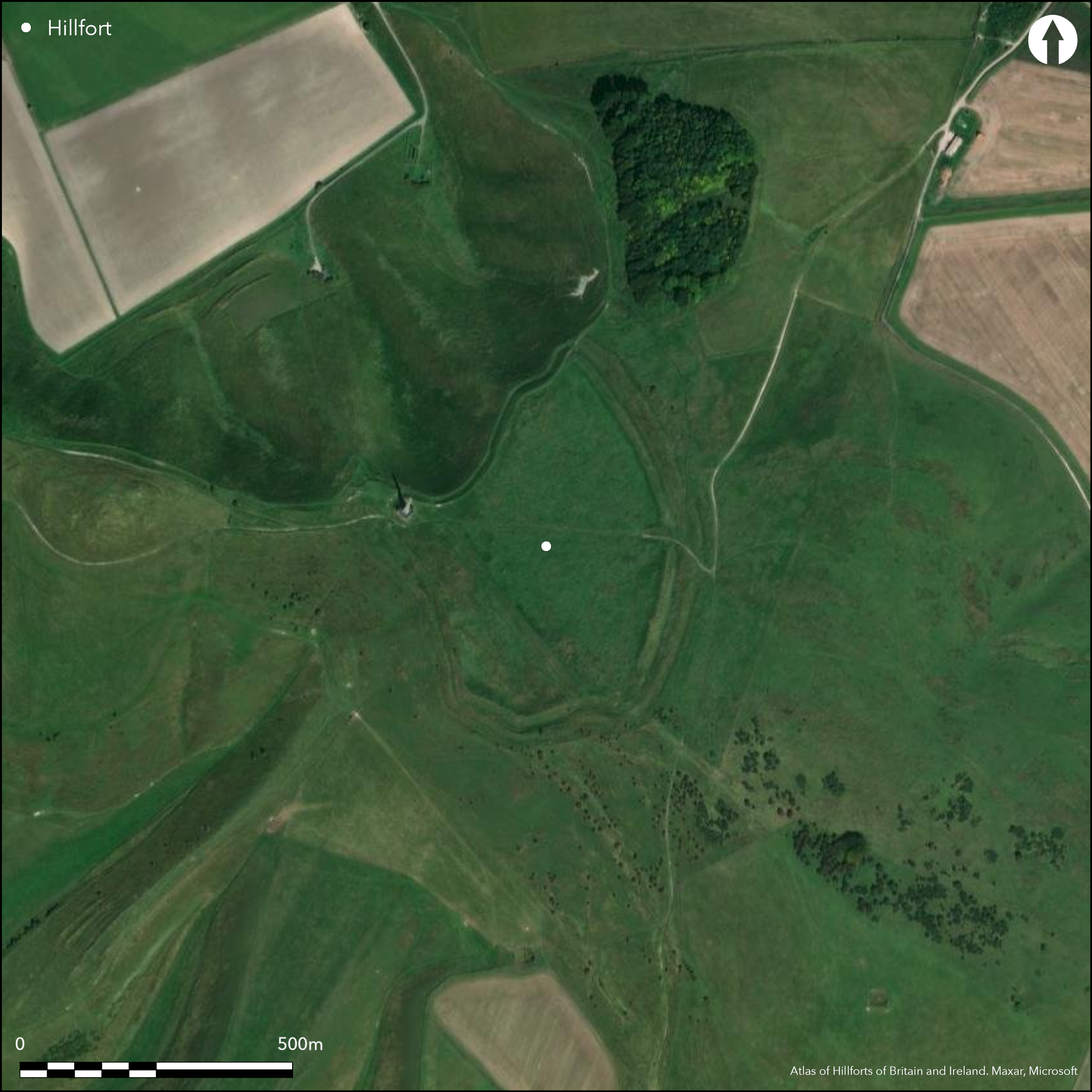
Satellite Imagery
LiDAR 1m DTM Hillshade
Satellite Imagery
Scroll left/right to view further images.
HER: Wiltshire and Swindon MWI8196 (None)
NMR: SU 06 NW 27 (215900)
SM: 1018611
NGR: SU 0490 6920
X: 404939 Y: 169280 (OSGB36)
Fine and massive, poorly understood, partial contour fort with curious triangular shape occupying Upper Chalk plateau top of Cherhill Hill and extending part-way down the W side to incorporate a false crest. Encloses 8ha. Bivallate except on N.W. where perimeter follows steep escarpment with poor bank, scarp and berm. On W outer ditch consists of pits separated by causeways of undisturbed ground. On E outer rampart constructed by heaping material from the ditch on E. and W, resulting in low bank of upcast on each side of broad top. Broad rampart and weak narrow ditch with a series of 'stepped' levels. These factors suggests outer rampart not finished. Site possibly constructed originally in Bronze Age as hilltop enclosure of bank and ditch surrounding c. 6ha, then enlarged to form present hillfort. Interior bisected by NW-SE bank following edge of plateau, formed from upcast of scarping with very weak narrow ditch on lower W ending short of escarpment. This may represent a boundary ditch pre-dating construction. Original inturned entrance on the E. flanked by outer rampart or barbican, with another possible entrance on SE. Break in NW recent or possibly greatly damaged original. Flint digging eroded much of interior of W enclosure and part of S rampart. No trace of habitation within fort apart from a depression, 10m. across and 0.4m. deep which may be possible hut site. Uncertain whether cross bank represents a Phase I stage in construction or later, although 2004 topographical survey suggested indeed Phase I and area to SW extension. English Heritage magnetometer survey as part of Wessex Hillforts Project in 1996 revealed an internal ditch dividing the N third of the hillfort from the remainder. This may represent a boundary ditch. In the N and E sectors of the fort, up to 20 faintly visible circular anomalies may indicate the positions of round timber buildings defined by outer ring-gullies. Scattered among these structures are more than 150 pits (Payne et al 2006). Lansdowne Monument erected in 1845 to commemorate Sir William Petty at NW corner. N of fort is the Cherhill White Horse, cut in 1780 by Dr C. Alsop of Calne in the style of the artist Stubbs. On 1st Ed OS map (1886).
Citizen Science: ✗
Reliability of Data: Confirmed
Reliability of Interpretation: Confirmed
X: -214888 Y: 6696365 (EPSG: 3857)
Longitude: -1.9303736539637983 Latitude: 51.422459026974664 (EPSG:4326)
Country: England
Current County or Unitary Authority: Wiltshire
Historic County: Wiltshire
Current Parish/Community/Council/Townland: Cherhill
Flint digging has eroded much of interior of W enclosure and part of S rampart. Lansdowne Monument at NW corner. A full topographic survey was carried out in advance of repair works to erosion scars at various points around the ramparts 2004.
| Extant | ✓ |
| Cropmark | ✗ |
| Likely Destroyed | ✓ |
Downland pasture.
| Woodland | ✗ |
| Commercial Forestry Plantation | ✗ |
| Parkland | ✗ |
| Pasture (Grazing) | ✓ |
| Arable | ✗ |
| Scrub/Bracken | ✗ |
| Bare Outcrop | ✗ |
| Heather/Moorland | ✗ |
| Heath | ✗ |
| Built-up | ✗ |
| Coastal Grassland | ✗ |
| Other | ✗ |
Fine and massive, poorly understood, bivallate and partial contour fort with curious triangular shape occupying Upper Chalk plateau top of Cherhill Hill and extending part-way down the W side to incorporate a false crest.
| Contour Fort | ✗ |
| Partial Contour Fort | ✓ |
| Promontory Fort | ✗ |
| Hillslope Fort | ✗ |
| Level Terrain Fort | ✗ |
| Marsh Fort | ✗ |
| Multiple Enclosure Fort | ✗ |
Fine strategic position to control both downland and vale resources on the escarpment edge of Cherhill Down (on Marlborough Downs), above the Cherhill Down White Horse at the headwaters of the River Marden, a tributary of the Somerset Avon. Curious shape partly dictated by topography and linear ditches (late Bronze Age) which approach the site from several directions and seem to influence the line of the ramparts. Parallels with Casterley Camp and Alfred's Castle (Brown et al 2005, 159).
| Hilltop | ✓ |
| Coastal Promontory | ✗ |
| Inland Promontory | ✗ |
| Valley Bottom | ✗ |
| Knoll/Hillock/Outcrop | ✗ |
| Ridge | ✗ |
| Cliff/Plateau-edge/Scarp | ✗ |
| Hillslope | ✗ |
| Lowland | ✗ |
| Spur | ✗ |
Dominant Topographic Feature: Plateau hill top.
| North | ✗ |
| Northeast | ✗ |
| East | ✗ |
| Southeast | ✗ |
| South | ✗ |
| Southwest | ✗ |
| West | ✗ |
| Northwest | ✓ |
| Level | ✗ |
Altitude: 250.0m
N/A
Site possibly constructed originally in Bronze Age as hilltop enclosure of bank and ditch surrounding c. 6ha, then enlarged to form hillfort. Iron Age pottery, haematite coated ware, loom weights, mullers, weaving comb, querns, metal objects from excavations.
Reliability: C - Low
| Pre 1200BC | ✗ |
| 1200BC - 800BC | ✗ |
| 800BC - 400BC | ✓ |
| 400BC - AD50 | ✓ |
| AD50 - AD400 | ✗ |
| AD400 - AD 800 | ✗ |
| Post AD800 | ✗ |
| Unknown | ✗ |
| Pre Hillfort: | None |
| Post Hillfort: | None |
| Artefactual: | None |
In Aubrey's Monumenta Britannica (1665-1693). On 1st Ed OS map (1886). Various 19th century excavations. Pits excavated 1875 by W. Cunnington. Excavation D.G. Blackford 1939. Geophysical survey part of Wessex Hillforts Project 1996. Measured survey M. Bowden 2004.
| Excavation (1858): | W. Cunnington. |
| Excavation (1875): | W. Cunninngton. |
| 1st Identified Map Depiction (1886): | OS map. |
| Excavation (1890): | W.C. Plenderleath. |
| Excavation (1939): | D.G. Blackford. |
| Geophysical Survey (1996): | Payne et al 2006 |
| Geophysical Survey (1996): | Wessex Hillforts Project. |
| Earthwork Survey (2004): | A full topographic survey was carried out in advance of repair works to erosion scars at various points around the ramparts, M. Bowden. |
| 1st Identified Written Reference (None): | In Aubrey's Monumenta Britannica. |
| Earthwork Survey (None): | E.H. Bowden. |
Magnetometer survey in 1996 revealed an internal ditch dividing N third of hillfort from remainder. Survey revealed ditches, ring gullies and pits. Iron Age pottery, haematite coated ware, loom weights, mullers, weaving comb, querns, metal objects, Roman coins of Domitian-Magnus Maximus. Pits excavated, first 1875 by Cunnington, and others after. Magnetometer survey in 1996 revealed internal ditch dividing the N third of the hillfort from remainder, possibly boundary ditch. In N and E sectors up to 20 faintly visible circular anomalies may indicate positions of round timber buildings defined by outer ring-gullies. Scattered among these structures are more than 150 pits.
None
| None | ✓ |
| Spring | ✗ |
| Stream | ✗ |
| Pool | ✗ |
| Flush | ✗ |
| Well | ✗ |
| Other | ✗ |
None
| No Known Features | ✓ |
| Round Stone Structures | ✗ |
| Rectangular Stone Structures | ✗ |
| Curvilinear Platforms | ✗ |
| Other Roundhouse Evidence | ✗ |
| Pits | ✗ |
| Quarry Hollows | ✗ |
| Other | ✗ |
Pits excavated, first 1875 by Cunnington, and others after. Magnetometer survey in 1996 revealed internal ditch dividing the N third of the hillfort from remainder, possibly boundary ditch. In N and E sectors up to 20 faintly visible circular anomalies may indicate positions of round timber buildings defined by outer ring-gullies. Scattered among these structures are more than 150 pits.
| No Known Excavation | ✗ |
| Pits | ✓ |
| Postholes | ✗ |
| Roundhouses | ✓ |
| Rectangular Structures | ✗ |
| Roads/Tracks | ✗ |
| Quarry Hollows | ✗ |
| Other | ✓ |
| Nothing Found | ✗ |
Magnetometer survey in 1996 revealed an internal ditch dividing N third of hillfort from remainder. Survey revealed ditches, ring gullies and pits.
| No Known Geophysics | ✗ |
| Pits | ✓ |
| Roundhouses | ✓ |
| Rectangular Structures | ✗ |
| Roads/Tracks | ✗ |
| Quarry Hollows | ✗ |
| Other | ✓ |
| Nothing Found | ✗ |
Iron Age pottery, haematite coated ware, loom weights, mullers, weaving comb, querns, metal objects, Roman coins of Domitian-Magnus Maximus.
| No Known Finds | ✗ |
| Pottery | ✓ |
| Metal | ✓ |
| Metalworking | ✗ |
| Human Bones | ✗ |
| Animal Bones | ✗ |
| Lithics | ✓ |
| Environmental | ✗ |
| Other | ✓ |
None
| APs Not Checked | ✓ |
| None | ✗ |
| Roundhouses | ✗ |
| Rectangular Structures | ✗ |
| Pits | ✗ |
| Postholes | ✗ |
| Roads/Tracks | ✗ |
| Other | ✗ |
To E inner bank turns in to form an entrance which is protected by a outer bank or barbican. Possible original entrance on SE corner. Modern gaps to W. Break in NW recent or possibly greatly damaged original.
| 4: | Modern gaps to W. Break in NW recent or possibly greatly damaged original. |
| 2: | To E inner bank turns in to form an entrance which is protected by a outer bank or barbican. |
Guard Chambers: ✗
Chevaux de Frise: ✗
| 1. In-turned (East): | With outer bank or barbican. |
| 1. Barbican (East): | Protected by a outer bank or barbican. |
| 2. Simple Gap (South east): | Possible original entrance. |
Bivallate except on NW where perimeter follows steep escarpment with poor bank, scarp and berm. On W outer ditch consists of pits separated by causeways of undisturbed ground. On E outer rampart constructed by heaping material from the ditch on E. and W., resulting in low bank of upcast on each side of broad top. Broad rampart and weak narrow ditch with a series of 'stepped' levels. these factors suggests outer rampart not finished.
| Area 1: | 6.0ha. |
| Area 2: | 8.0ha. |
| Total: | 8.0ha. |
Total Footprint Area: Noneha.
None
| ✓ | Possible phased construction. Site possibly constructed originally in Bronze Age as hilltop enclosure of bank and ditch surrounding c. 6ha, then enlarged to form present hillfort. |
| ✓ | None |
| NE Quadrant: | 2 |
| SE Quadrant: | 2 |
| SW Quadrant: | 2 |
| NW Quadrant: | 1 |
| Total: | 2 |
| Partial Univallate | ✓ |
| Univallate | ✗ |
| Partial Bivallate | ✓ |
| Bivallate | ✗ |
| Partial Multivallate | ✗ |
| Multivallate | ✗ |
| Unknown | ✗ |
| Partial Univallate | ✗ |
| Univallate | ✓ |
| Partial Bivallate | ✗ |
| Bivallate | ✗ |
| Partial Multivallate | ✗ |
| Multivallate | ✗ |
None
| None | ✗ |
| Earthen Bank | ✓ |
| Stone Wall | ✗ |
| Rubble | ✗ |
| Wall-walk | ✗ |
| Evidence of Timber | ✗ |
| Vitrification | ✗ |
| Other Burning | ✗ |
| Palisade | ✗ |
| Counter Scarp Bank | ✗ |
| Berm | ✓ |
| Unfinished | ✗ |
| Other | ✗ |
Excavations generally confined to pits.
| None | ✗ |
| Earthen Bank | ✗ |
| Stone Wall | ✗ |
| Murus Duplex | ✗ |
| Timber-framed | ✗ |
| Timber-laced | ✗ |
| Vitrification | ✗ |
| Other Burning | ✗ |
| Palisade | ✗ |
| Counter Scarp Bank | ✗ |
| Berm | ✗ |
| Unfinished | ✗ |
| No Known Excavation | ✓ |
| Other | ✗ |
| ✗ | None |
| ✓ | None |
Number of Ditches: 1
| ✗ | None |
Bowden M. 2004. Oldbury Castle Hillfort, Wiltshire, Unpublished report AI/31/2004.
Bowden, M. 2005. The middle Iron Age on the Marlborough Downs, in eds G. Brown, D. Field and D. McOmish, The Avebury landscape, Oxford: Oxbow Books, 156-63.
Cunnington, H. 1871. Oldbury Camp, Wiltshire, Wiltshire Archaeol Natur Hist Mag, 28, 277.
Cunnington, W. 1893: Notes on food vessels from Oldbury Hill, Wiltshire Archaeol Natur Hist Mag, 33, 131-38.
Darvill, T., Stamper, P. and Timby, J. 2002: England an archaeological guide. Oxford: OUP, 402-03.
Payne, A., Corney, M. and Cunliffe, B. 2006. The Wessex Hillforts Project. Extensive survey of hillfort interiors in Cenral Southern England, London: English Heritage, 123-27.
Atlas of Hillforts:
Wikidata:
This work is licensed under CC BY-SA 4.0

 and should be cited as:
Lock, Gary and Ralston, Ian. 2024. Atlas of Hillforts of Britain and Ireland. Available at: https://hillforts.arch.ox.ac.uk
Document Version 1.1