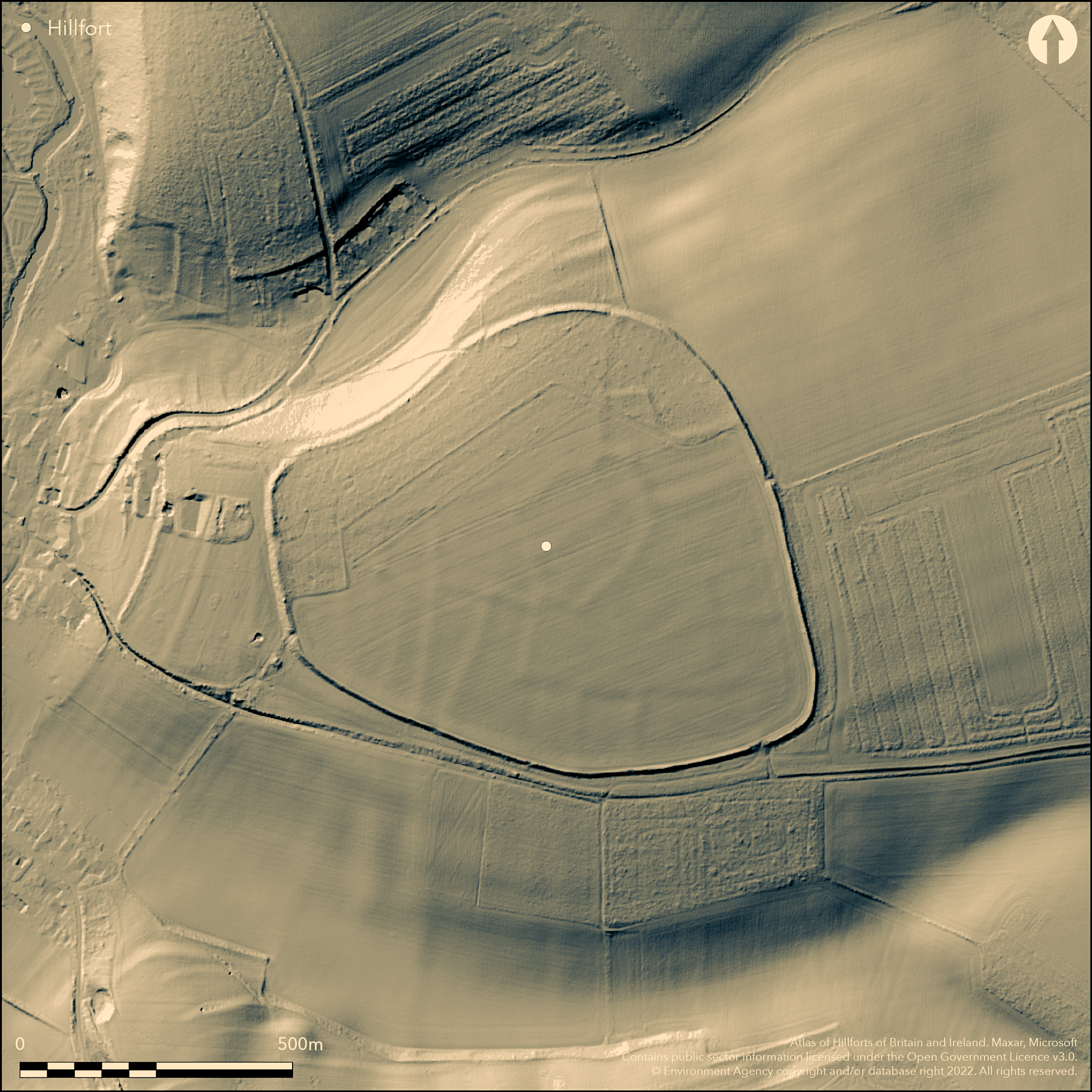
LiDAR 1m DTM Hillshade
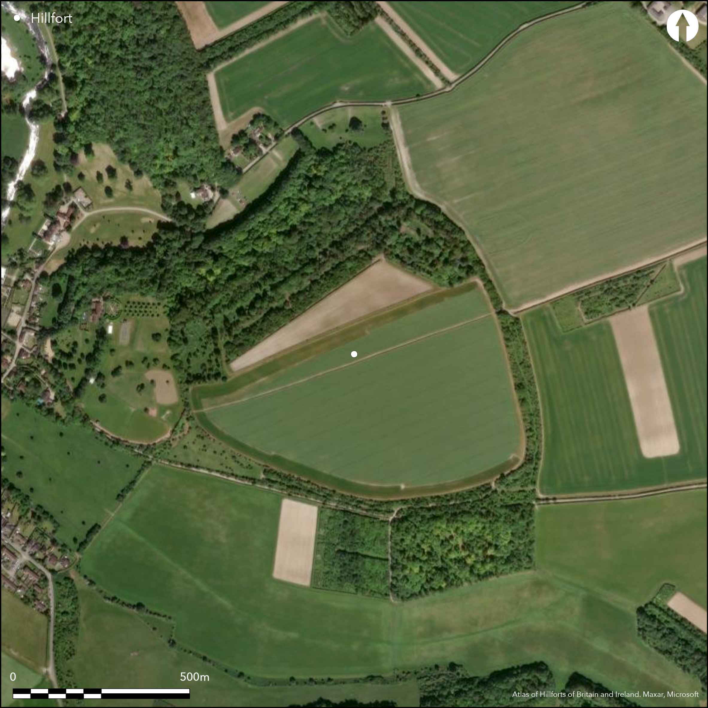
Satellite Imagery
LiDAR 1m DTM Hillshade
Satellite Imagery
Scroll left/right to view further images.
HER: Wiltshire and Swindon MWI10612 (None)
NMR: SU 13 NW 9 (218235)
SM: 1005677
NGR: SU14323829
X: 414320 Y: 138294 (OSGB36)
Very large, univallate, partial contour fort (bank cuts across contours on E) located on prominent downland spur above E bank of River Avon. Domed interior. Steep surrounding slopes to W and S, level entry on E. Single rampart rampart and ditch encloses 26ha, now slight bank/scarp for most of circuit, best on N where reach 3.9m high. Fragmentary on E to 1.6m max. Ditch entirely levelled/filled-in now buried feature. Only original entrance on E side, clearly shown on Philip Crocker's plan of site in Colt Hoare (1812). Other gaps modern, including that on NW the result of 18th/19th century landscaping of interior. Iron Age sherds found in the rampart on S. Part-wooded and cultivated enclosed area divided up by field system, visible on aerial photographs, and in important area for associated field systems, which could be significant in location. Possible that interior field system could indicate later use as farmstead. Small excavation by W. Cunnington Sen.1800-10. On Ist Ed. OS map (1871-78).
Citizen Science: ✗
Reliability of Data: Confirmed
Reliability of Interpretation: Confirmed
X: -200007 Y: 6646748 (EPSG: 3857)
Longitude: -1.7966899702355088 Latitude: 51.143677375043964 (EPSG:4326)
Country: England
Current County or Unitary Authority: Wiltshire
Historic County: Wiltshire
Current Parish/Community/Council/Townland: Durnford
Ramparts now slight bank/scarp for most of circuit, best on N. Fragmentary on E. Cultivated interior. Ditched entirely levelled/filled in now buried feature. On Heritage at Risk Register (2015).
| Extant | ✓ |
| Cropmark | ✗ |
| Likely Destroyed | ✗ |
Woodland on far N; cultivated/pasture on remainder.
| Woodland | ✓ |
| Commercial Forestry Plantation | ✗ |
| Parkland | ✗ |
| Pasture (Grazing) | ✓ |
| Arable | ✗ |
| Scrub/Bracken | ✗ |
| Bare Outcrop | ✗ |
| Heather/Moorland | ✗ |
| Heath | ✗ |
| Built-up | ✗ |
| Coastal Grassland | ✗ |
| Other | ✗ |
Very large, univallate, partial contour fort (bank cuts across contours on E) located on prominent downland spur above E bank of River Avon. Domed interior. Steep surrounding slopes to W and S, level entry on E.
| Contour Fort | ✗ |
| Partial Contour Fort | ✓ |
| Promontory Fort | ✗ |
| Hillslope Fort | ✗ |
| Level Terrain Fort | ✗ |
| Marsh Fort | ✗ |
| Multiple Enclosure Fort | ✗ |
Located on the edge of the downs on a spur in a strategic position immediately above the River Avon in an area of significant field systems.
| Hilltop | ✗ |
| Coastal Promontory | ✗ |
| Inland Promontory | ✗ |
| Valley Bottom | ✗ |
| Knoll/Hillock/Outcrop | ✗ |
| Ridge | ✗ |
| Cliff/Plateau-edge/Scarp | ✗ |
| Hillslope | ✗ |
| Lowland | ✗ |
| Spur | ✓ |
Dominant Topographic Feature: Downland spur.
| North | ✗ |
| Northeast | ✗ |
| East | ✓ |
| Southeast | ✗ |
| South | ✗ |
| Southwest | ✗ |
| West | ✗ |
| Northwest | ✗ |
| Level | ✗ |
Altitude: 110.0m
N/A
Iron Age sherds found in the rampart on S.
Reliability: C - Low
| Pre 1200BC | ✗ |
| 1200BC - 800BC | ✗ |
| 800BC - 400BC | ✗ |
| 400BC - AD50 | ✓ |
| AD50 - AD400 | ✗ |
| AD400 - AD 800 | ✗ |
| Post AD800 | ✗ |
| Unknown | ✗ |
| Pre Hillfort: | None |
| Post Hillfort: | None |
| Artefactual: | Iron Age sherds found in the rampart on S. |
On Ist Ed. OS map (1871-78). In Aubrey's Monumenta Britannica (1665-1693). Excavation 1800-10 by W. Cunnington Sen. Measured survey RCHME indated. Aerial photograph interpretation, EH Stonehenge Mapping Programme. Earliest identified map reference Andrews and Dury Map of Wiltshire 1773. Earliest written reference 1649 Ogbury Camp is 'downe called Oakebery', no further details.
| 1st Identified Written Reference (1649): | Ogbury Camp is 'downe called Oakebery', no further details |
| 1st Identified Map Depiction (1812): | Philip Crocker's plan of site in Colt Hoare (1812). |
| Other (1984): | Visited by Hillfort Study Group |
| Other (2001): | Aerial Photograph Interpretation , EH: Stonehenge WHS Mapping Programme. |
| Excavation (None): | W. Cunnington Sen. |
| Other (None): | OS map. |
| Other (None): | Measured survey RCHME. |
Cunnington excavation showed no features. Iron Age sherds found in the rampart on S. Interior divided up by field system, visible on aerial photographs, and in important area for associated field systems, which could be significant in location. Colt Hoare excavation showed no features.
None
| None | ✓ |
| Spring | ✗ |
| Stream | ✗ |
| Pool | ✗ |
| Flush | ✗ |
| Well | ✗ |
| Other | ✗ |
None
| No Known Features | ✓ |
| Round Stone Structures | ✗ |
| Rectangular Stone Structures | ✗ |
| Curvilinear Platforms | ✗ |
| Other Roundhouse Evidence | ✗ |
| Pits | ✗ |
| Quarry Hollows | ✗ |
| Other | ✗ |
Cunnington excavation showed no features.
| No Known Excavation | ✗ |
| Pits | ✗ |
| Postholes | ✗ |
| Roundhouses | ✗ |
| Rectangular Structures | ✗ |
| Roads/Tracks | ✗ |
| Quarry Hollows | ✗ |
| Other | ✗ |
| Nothing Found | ✓ |
None
| No Known Geophysics | ✓ |
| Pits | ✗ |
| Roundhouses | ✗ |
| Rectangular Structures | ✗ |
| Roads/Tracks | ✗ |
| Quarry Hollows | ✗ |
| Other | ✗ |
| Nothing Found | ✗ |
Iron Age sherds found in the rampart on S.
| No Known Finds | ✗ |
| Pottery | ✓ |
| Metal | ✗ |
| Metalworking | ✗ |
| Human Bones | ✗ |
| Animal Bones | ✗ |
| Lithics | ✗ |
| Environmental | ✗ |
| Other | ✗ |
Interior divided up by field system, visible on aerial photographs, and in important area for associated field systems, which could be significant in location.
| APs Not Checked | ✗ |
| None | ✗ |
| Roundhouses | ✗ |
| Rectangular Structures | ✗ |
| Pits | ✗ |
| Postholes | ✗ |
| Roads/Tracks | ✗ |
| Other | ✓ |
Only original entrance on E side, clearly shown on Philip Crocker's plan of site in Colt Hoare (1812). 5 other gaps modern, including that on NW the result of 18th/19th century landscaping of interior.
| 6: | None |
| 2: | None |
Guard Chambers: ✗
Chevaux de Frise: ✗
| 1. Simple Gap (East): | None |
Single rampart rampart now slight bank/scarp for most of circuit, best on N where reach 3.9m high. Fragmentary on E to 1.6m max. Ditch entirely levelled/filled-in now buried feature.
| Area 1: | 26.0ha. |
| Total: | 26.0ha. |
Total Footprint Area: Noneha.
None
| ✗ | None |
| ✓ | None |
| NE Quadrant: | 1 |
| SE Quadrant: | 1 |
| SW Quadrant: | 1 |
| NW Quadrant: | 1 |
| Total: | 1 |
| Partial Univallate | ✗ |
| Univallate | ✓ |
| Partial Bivallate | ✗ |
| Bivallate | ✗ |
| Partial Multivallate | ✗ |
| Multivallate | ✗ |
| Unknown | ✗ |
| Partial Univallate | ✗ |
| Univallate | ✗ |
| Partial Bivallate | ✗ |
| Bivallate | ✗ |
| Partial Multivallate | ✗ |
| Multivallate | ✗ |
None
| None | ✗ |
| Earthen Bank | ✓ |
| Stone Wall | ✗ |
| Rubble | ✗ |
| Wall-walk | ✗ |
| Evidence of Timber | ✗ |
| Vitrification | ✗ |
| Other Burning | ✗ |
| Palisade | ✗ |
| Counter Scarp Bank | ✗ |
| Berm | ✗ |
| Unfinished | ✗ |
| Other | ✗ |
None
| None | ✗ |
| Earthen Bank | ✗ |
| Stone Wall | ✗ |
| Murus Duplex | ✗ |
| Timber-framed | ✗ |
| Timber-laced | ✗ |
| Vitrification | ✗ |
| Other Burning | ✗ |
| Palisade | ✗ |
| Counter Scarp Bank | ✗ |
| Berm | ✗ |
| Unfinished | ✗ |
| No Known Excavation | ✓ |
| Other | ✗ |
| ✗ | None |
| ✓ | The ditch is completely levelled/filled-in now buried feature. |
Number of Ditches: 1
| ✗ | None |
Hoare, R.C. 1812. The ancient history of South Wiltshire, Vol 1, London: William Miller, 219-20, (re-published 1975, Wakefield: EP publishing).
Pugh, R.B. and Crittall, E. eds 1957. A history of Wiltshire, 1.1, The Victoria history of the counties of England, Oxford: OUP, 65, 265.
Atlas of Hillforts:
Wikidata:
This work is licensed under CC BY-SA 4.0

 and should be cited as:
Lock, Gary and Ralston, Ian. 2024. Atlas of Hillforts of Britain and Ireland. Available at: https://hillforts.arch.ox.ac.uk
Document Version 1.1