LiDAR 1m DTM Hillshade
Satellite Imagery
LiDAR 1m DTM Hillshade
Satellite Imagery
Scroll left/right to view further images.
HER: Wiltshire and Swindon MWI14758 (None)
NMR: SU 16 SE 6 (220993)
SM: 1065676
NGR: SU17406397
X: 417401 Y: 163970 (OSGB36)
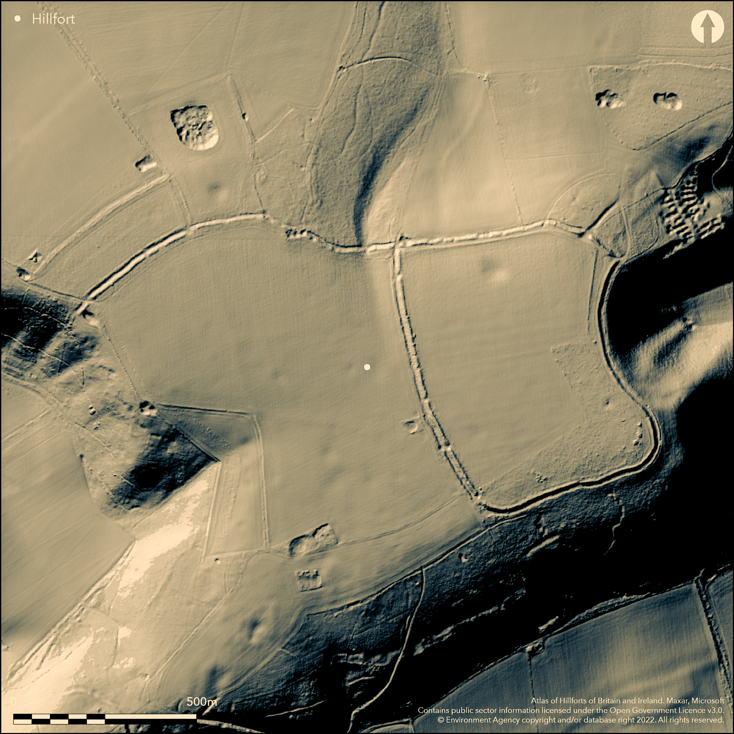
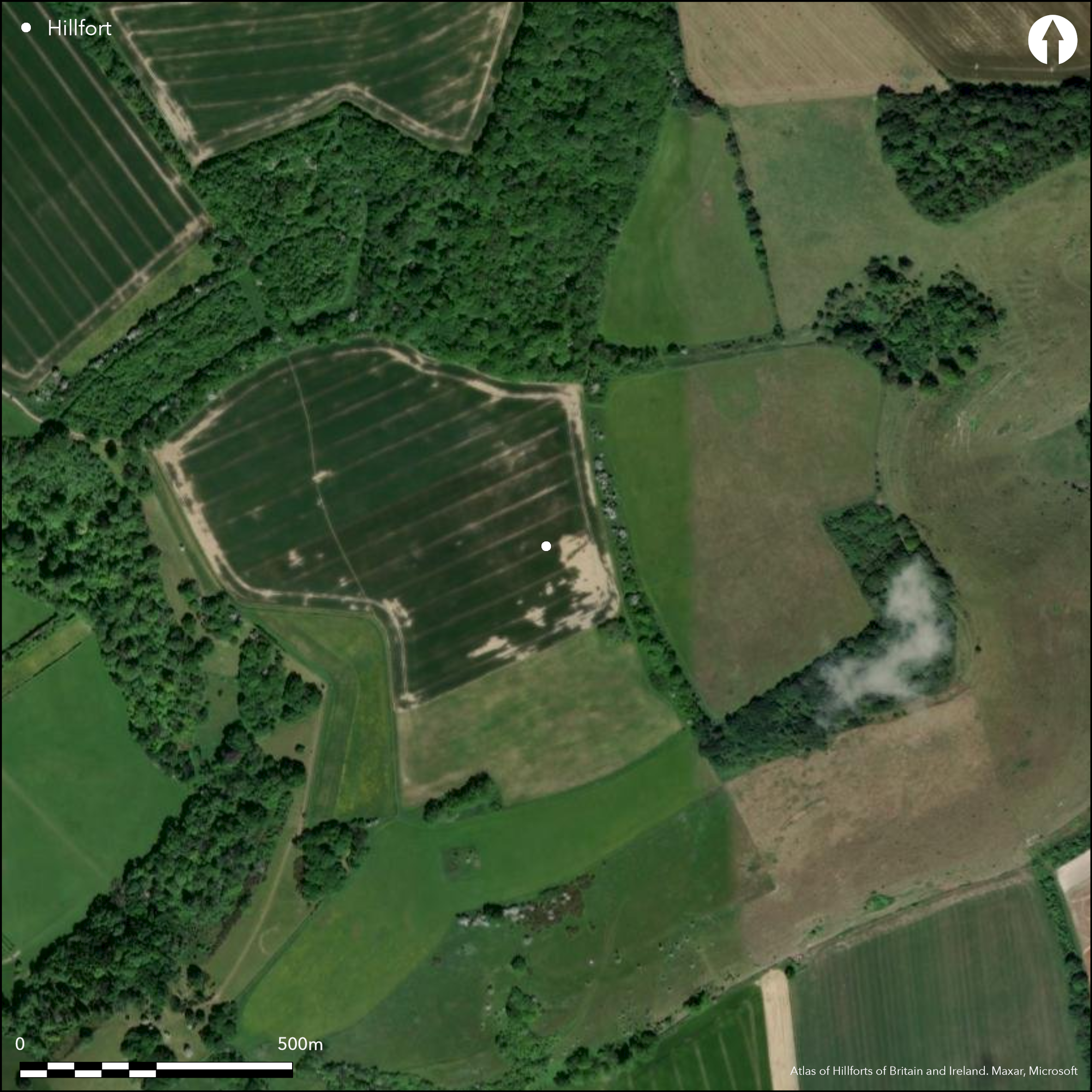
Large, univallate, partial contour hillfort located on the steep downland spur of Martinsell Hill jutting out into Vale of Pewsey and just to NW of Giant's Grave. Rectilinear in shape comprises single rampart and ditch 2.8m-3.2m high with outer ditch 1m deep, enclosing 13ha. Numerous modern breaks occur around the circuit, but those at NE and SW are probably original entrances. NE entrance damaged by later hollow way running c. 70m to NE. Here ditch has outer bank 1m high running c. 60m on either side of entrance. To E ditch fades into terrace on which modern boundary bank, re-forming at SW angle where another entrance damaged by later trackway. The NW angle mutilated by quarry and outer ditch destroyed on N. Called 'Maetelmesburg' in 8th century. Has been called 'hilltop enclosure' by Bowden (2005, 159). Geophysical survey showed little internal activity (Payne et al 2006), but numerous Iron Age and Roman chance finds in fort and nearby suggest that detailed excavation of fort could yield results. Under cultivation and part woodland to NE and SE. On Ist Ed. OS map (1886-87).
Citizen Science: ✓
Reliability of Data: Confirmed
Reliability of Interpretation: Confirmed
X: -194965 Y: 6687802 (EPSG: 3857)
Longitude: -1.7514045214423544 Latitude: 51.374469518906594 (EPSG:4326)
Country: England; None
Current County or Unitary Authority: Wiltshire
Historic County: Wiltshire
Current Parish/Community/Council/Townland: Milton Libourne; Pewsey; Savernake
Numerous modern gaps in defences. Entrances damaged and NW angle mutilated by quarry and outer ditch destroyed on N.
| Extant | ✓ |
| Cropmark | ✗ |
| Likely Destroyed | ✗ |
Under cultivation and part woodland to NE and SE. Quarry.
| Woodland | ✓ |
| Commercial Forestry Plantation | ✗ |
| Parkland | ✗ |
| Pasture (Grazing) | ✗ |
| Arable | ✓ |
| Scrub/Bracken | ✗ |
| Bare Outcrop | ✗ |
| Heather/Moorland | ✗ |
| Heath | ✗ |
| Built-up | ✗ |
| Coastal Grassland | ✗ |
| Other | ✓ |
Large, univallate, partial contour hillfort located on the steep downland spur of Martinsell Hill jutting out into Vale of Pewsey and just to NW of Giant's Grave.
| Contour Fort | ✗ |
| Partial Contour Fort | ✓ |
| Promontory Fort | ✗ |
| Hillslope Fort | ✗ |
| Level Terrain Fort | ✗ |
| Marsh Fort | ✗ |
| Multiple Enclosure Fort | ✗ |
Sited on the steep spur of Martinsell Hill jutting out into the Vale of Pewsey and just to the north-east of Giant's Grave.
| Hilltop | ✗ |
| Coastal Promontory | ✗ |
| Inland Promontory | ✗ |
| Valley Bottom | ✗ |
| Knoll/Hillock/Outcrop | ✗ |
| Ridge | ✗ |
| Cliff/Plateau-edge/Scarp | ✗ |
| Hillslope | ✗ |
| Lowland | ✗ |
| Spur | ✓ |
Dominant Topographic Feature: Steep downland spur.
| North | ✗ |
| Northeast | ✗ |
| East | ✗ |
| Southeast | ✗ |
| South | ✗ |
| Southwest | ✗ |
| West | ✗ |
| Northwest | ✓ |
| Level | ✗ |
Altitude: 289.0m
Three parishes
Boundary Type: Parish/Townland
Probable Iron Age date. Numerous Iron Age and Roman chance finds nearby suggest that detailed excavation of fort could yield results.
Reliability: C - Low
| Pre 1200BC | ✗ |
| 1200BC - 800BC | ✗ |
| 800BC - 400BC | ✗ |
| 400BC - AD50 | ✓ |
| AD50 - AD400 | ✗ |
| AD400 - AD 800 | ✗ |
| Post AD800 | ✗ |
| Unknown | ✗ |
| Pre Hillfort: | None |
| Post Hillfort: | None |
| Artefactual: | Chance finds nearby. |
Called 13th century 'Mattelsore'. In Aubrey's Monumenta Britannica (1665-1693). On Ist Ed. OS map (1886-87). Sketch Plan A.J. Hubbard 1907. Watching Brief 1976. English Heritage Wessex Hillforts Project Payne et al 2006. Called 'Maetelmesburg' in 8th century.
| Other (1907): | Sketch Plan A.J. Hubbard. |
| Other (1976): | Watching Brief - no archaeology. |
| Other (1976): | Watching Brief. |
| Geophysical Survey (1996): | Wessex Hillforts Project. |
| 1st Identified Written Reference (None): | Called 13th century 'Mattelsore'. |
| Other (None): | In Aubrey's Monumenta Britannica. |
| 1st Identified Map Depiction (None): | OS 2,500 map. |
| 1st Identified Written Reference (None): | Called 'Maetelmesburg' in 8th century. |
Iron Age sherds, including fragments of haematite-coated bowls and stamped, incised and finger decorated wares and Roman sherds including 1st and 2nd century Samian and Savernake wares and some 3rd and 4th century fragments of ampulla, and part of red deer antler from rampart . Also coin of Cunobelin and Eppaticus nearby. Iron Age sherds found by Meyrick in quantity outside fort to W and NE and three Romano-British sherds just to W. Geophysical survey showed little internal activity (Payne et al 2006).
None
| None | ✓ |
| Spring | ✗ |
| Stream | ✗ |
| Pool | ✗ |
| Flush | ✗ |
| Well | ✗ |
| Other | ✗ |
None
| No Known Features | ✓ |
| Round Stone Structures | ✗ |
| Rectangular Stone Structures | ✗ |
| Curvilinear Platforms | ✗ |
| Other Roundhouse Evidence | ✗ |
| Pits | ✗ |
| Quarry Hollows | ✗ |
| Other | ✗ |
None
| No Known Excavation | ✓ |
| Pits | ✗ |
| Postholes | ✗ |
| Roundhouses | ✗ |
| Rectangular Structures | ✗ |
| Roads/Tracks | ✗ |
| Quarry Hollows | ✗ |
| Other | ✗ |
| Nothing Found | ✗ |
Geophysical survey showed little internal activity (Payne et al 2006).
| No Known Geophysics | ✗ |
| Pits | ✗ |
| Roundhouses | ✗ |
| Rectangular Structures | ✗ |
| Roads/Tracks | ✗ |
| Quarry Hollows | ✗ |
| Other | ✗ |
| Nothing Found | ✓ |
Chance finds of Iron Age sherds, including fragments of haematite-coated bowls and stamped, incised and finger decorated wares and Roman sherds including 1st and 2nd century Samian and Savernake wares and some 3rd and 4th century fragments of ampulla, and part of red deer antler from rampart. Also coin of Cunobelin and Eppaticus nearby. Iron Age sherds also found by Meyrick in quantity outside fort to W and NE and three Romano-British sherds just to W.
| No Known Finds | ✗ |
| Pottery | ✓ |
| Metal | ✗ |
| Metalworking | ✗ |
| Human Bones | ✗ |
| Animal Bones | ✓ |
| Lithics | ✗ |
| Environmental | ✗ |
| Other | ✗ |
None
| APs Not Checked | ✓ |
| None | ✗ |
| Roundhouses | ✗ |
| Rectangular Structures | ✗ |
| Pits | ✗ |
| Postholes | ✗ |
| Roads/Tracks | ✗ |
| Other | ✗ |
Numerous modern breaks occur around the circuit, but those at NE and SW are probably original entrances. NE entrance damaged by later hollow way running c. 70m to NE. Here ditch has outer bank 1m high running c. 60m on either side of entrance. To E ditch fades into terrace on which modern boundary bank, re-forming at SW angle where another entrance damaged by later trackway. The
| 15: | Numerous modern breaks on N and W sides. |
| 2: | None |
Guard Chambers: ✗
Chevaux de Frise: ✗
| 1. Simple Gap (North east): | Damaged by later hollow way. |
| 1. Outworks (North east): | Ditch has outer bank 1m high running c. 60m on either side of entrance. |
| 2. Simple Gap (South west): | Damage by later trackway. |
Rectilinear in shape comprises single rampart and ditch 2.8m-3.2m high with outer ditch 1m deep. Ditch at NE entrance has outer bank 1m high running c. 60m on either side of entrance. To E ditch fades into terrace on which modern boundary bank, re-forming at SW angle where another entrance damaged by later trackway. The NW angle mutilated by quarry and outer ditch destroyed on N.
| Area 1: | 13.0ha. |
| Total: | 13.0ha. |
Total Footprint Area: Noneha.
None
| ✗ | None |
| ✓ | None |
| NE Quadrant: | 1 |
| SE Quadrant: | 1 |
| SW Quadrant: | 1 |
| NW Quadrant: | 1 |
| Total: | 1 |
| Partial Univallate | ✗ |
| Univallate | ✓ |
| Partial Bivallate | ✗ |
| Bivallate | ✗ |
| Partial Multivallate | ✗ |
| Multivallate | ✗ |
| Unknown | ✗ |
| Partial Univallate | ✗ |
| Univallate | ✗ |
| Partial Bivallate | ✗ |
| Bivallate | ✗ |
| Partial Multivallate | ✗ |
| Multivallate | ✗ |
None
| None | ✗ |
| Earthen Bank | ✓ |
| Stone Wall | ✗ |
| Rubble | ✗ |
| Wall-walk | ✗ |
| Evidence of Timber | ✗ |
| Vitrification | ✗ |
| Other Burning | ✗ |
| Palisade | ✗ |
| Counter Scarp Bank | ✗ |
| Berm | ✗ |
| Unfinished | ✗ |
| Other | ✗ |
None
| None | ✗ |
| Earthen Bank | ✗ |
| Stone Wall | ✗ |
| Murus Duplex | ✗ |
| Timber-framed | ✗ |
| Timber-laced | ✗ |
| Vitrification | ✗ |
| Other Burning | ✗ |
| Palisade | ✗ |
| Counter Scarp Bank | ✗ |
| Berm | ✗ |
| Unfinished | ✗ |
| No Known Excavation | ✓ |
| Other | ✗ |
| ✗ | None |
| ✓ | None |
Number of Ditches: 1
| ✗ | None |
Bowden, M. 2005. The middle Iron Age on the Marlborough Downs, in eds G. Brown, D. Field and D. McOmish, The Avebury landscape, Oxford: Oxbow Books, 156-63.
Payne, A., Corney, M. and Cunliffe, B. 2006. The Wessex Hillforts Project. Extensive survey of hillfort interiors in Cenral Southern England, London: English Heritage, 118-23.
Pugh, R.B. and Crittall, E. eds 1957. A history of Wiltshire, 1.1, The Victoria history of the counties of England, Oxford: OUP, 180.
Atlas of Hillforts:
Wikidata:
This work is licensed under CC BY-SA 4.0![]()
![]()
![]() and should be cited as:
and should be cited as:
Lock, Gary and Ralston, Ian. 2024. Atlas of Hillforts of Britain and Ireland. Available at: https://hillforts.arch.ox.ac.uk
Document Version 1.1