LiDAR 1m DTM Hillshade
Satellite Imagery
LiDAR 1m DTM Hillshade
Satellite Imagery
Scroll left/right to view further images.
HER: Wiltshire and Swindon MWI3858 (None)
NMR: ST 94 SW 1 (211396)
SM: 1010213
NGR: ST91284424
X: 391280 Y: 144242 (OSGB36)
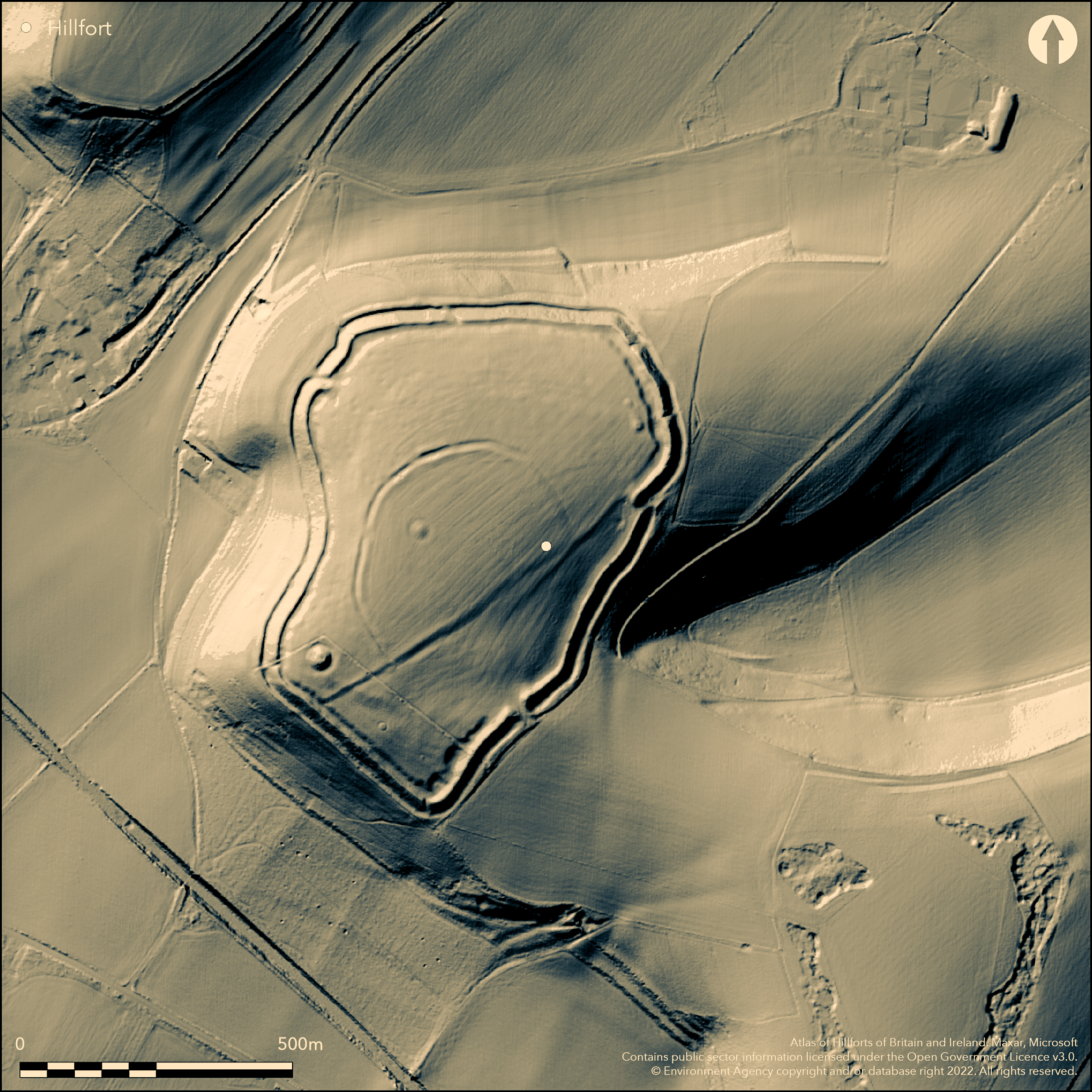
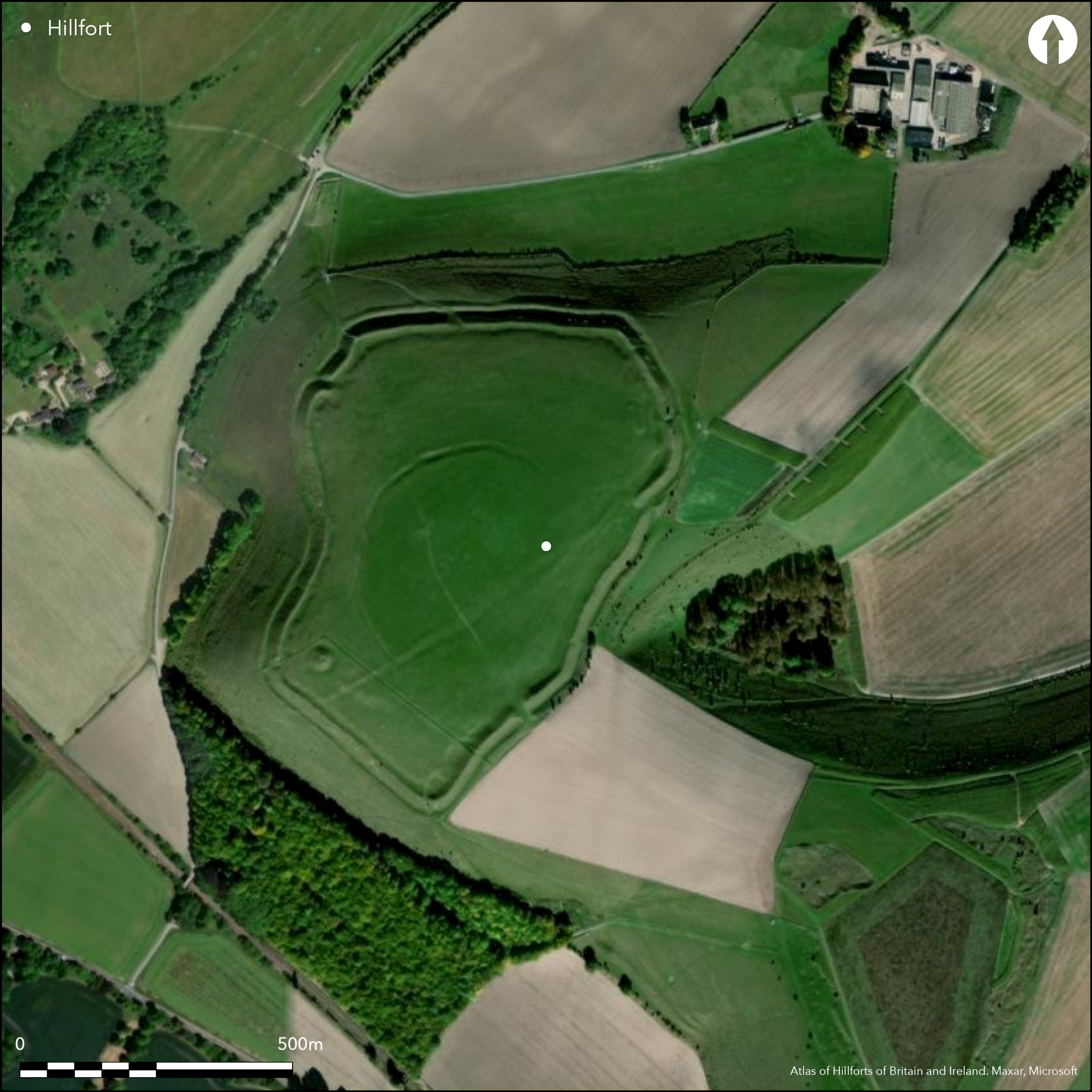
Large, univallate, contour hillfort located on the Upper Chalk at the S edge of the Salisbury Plain Chalk Massif with extensive views overlooking the lower Wylye Valley to the S. Defences cut off the site from rest of the chalk spur, similar to that at Battlesbury (Atlas No 0386) located 1km to the NE, separated only by Middle Hill. In MOD Salisbury Plain Training Area. Very steep on W and SW sides. Steep on N and NE with level to moderate sloping to SE above steep-sided combe cutting into hillside on E. Interior area 17ha. Defined by single bank with external ditch, best preserved on W where rampart stands to height of c. 6m above ditch bottom and c. 15m wide at base. Ditch c. 5m-8m wide and up to 1m deep. Elsewhere, hillfort defined by bank 3m-6m in height above ditch bottom, the ditch being c. 4m-6m wide and up to 0.5m deep. On E side ditch absent and replaced by ledge c. 3m-8m wide. Crest of rampart undulating, mirrored in the ditch, possibly suggesting gang working. Quarry scoop behind rampart and many circular and curvilinear depressions possibly structures. Three main entrances in E, SE and NW, all probably original. SE, and simplest, single gap of c. 20m between rampart and ditch terminals, E and NW off-set at 7m and 15m gap respectively. Several small depressions by NW entrance possibly hut sites. D-shaped enclosure in the centre hillfort previously interpreted as Neolithic causewayed enclosure due to interrupted nature and the discovery of jade and flint axes. Excavations by W.F. Grimes subsequently shown this to be Iron Age, with Iron Age pottery in the primary fill, and interruptions probably result of post medieval ploughing, with only one well-defined lynchet visible. Much of N and W of interior densely settled and c.100 probable structures identified, surviving mainly as circular hollows c. 5m-10m diameter up to 0.6m deep. Six round barrows on hill (one at highest point) and in 1804 Roman bronze spoon found. Roman pottery also recorded by Colt Hoare (1812). Downland pasture. Good condition. On Ist Ed. OS map (1887).
Citizen Science: ✓
Reliability of Data: Confirmed
Reliability of Interpretation: Confirmed
X: -236687 Y: 6656263 (EPSG: 3857)
Longitude: -2.1261990295979896 Latitude: 51.19727137714082 (EPSG:4326)
Country: England
Current County or Unitary Authority: Wiltshire
Historic County: Wiltshire
Current Parish/Community/Council/Townland: Norton Bavant
Good condition. SSSI.
| Extant | ✓ |
| Cropmark | ✗ |
| Likely Destroyed | ✗ |
Downland pasture.
| Woodland | ✗ |
| Commercial Forestry Plantation | ✗ |
| Parkland | ✗ |
| Pasture (Grazing) | ✓ |
| Arable | ✗ |
| Scrub/Bracken | ✗ |
| Bare Outcrop | ✗ |
| Heather/Moorland | ✗ |
| Heath | ✗ |
| Built-up | ✗ |
| Coastal Grassland | ✗ |
| Other | ✗ |
Large, univallate, contour hillfort located on the Upper Chalk at the S edge of the Salisbury Plain Chalk Massif, with extensive views overlooking the lower Wylye Valley to the S. Domed interior. Very steep on W and SW sides. Steep on N and NE with level to moderate sloping to SE above steep-sided combe cutting into hillside on E.
| Contour Fort | ✓ |
| Partial Contour Fort | ✗ |
| Promontory Fort | ✗ |
| Hillslope Fort | ✗ |
| Level Terrain Fort | ✗ |
| Marsh Fort | ✗ |
| Multiple Enclosure Fort | ✗ |
Located on a downland spur above the River Wylye
| Hilltop | ✓ |
| Coastal Promontory | ✗ |
| Inland Promontory | ✗ |
| Valley Bottom | ✗ |
| Knoll/Hillock/Outcrop | ✗ |
| Ridge | ✗ |
| Cliff/Plateau-edge/Scarp | ✗ |
| Hillslope | ✗ |
| Lowland | ✗ |
| Spur | ✗ |
Dominant Topographic Feature: Hill top
| North | ✗ |
| Northeast | ✗ |
| East | ✗ |
| Southeast | ✗ |
| South | ✗ |
| Southwest | ✗ |
| West | ✗ |
| Northwest | ✗ |
| Level | ✓ |
Altitude: 196.0m
N/A
Iron Age pottery found in interior enclosure.
Reliability: B - Medium
| Pre 1200BC | ✗ |
| 1200BC - 800BC | ✗ |
| 800BC - 400BC | ✓ |
| 400BC - AD50 | ✓ |
| AD50 - AD400 | ✗ |
| AD400 - AD 800 | ✗ |
| Post AD800 | ✗ |
| Unknown | ✗ |
| Pre Hillfort: | None |
| Post Hillfort: | None |
| Artefactual: | Iron Age pottery found in interior enclosure. |
In Aubrey's Monumenta Britannica (1665-1693). On Ist Ed. OS map (1887). Excavation W Cunnington Sen 1800-10. Excavation by W.F. Grimes 1957. Measured survey RCHME: South Wiltshire Project, ref. no. 831573. RCHME field survey Salisbury Plain Training Area, ref. no. 888341. LiDAR plan (Citizen Science)
| 1st Identified Map Depiction (1887): | OS map |
| Excavation (1957): | W.F. Grimes |
| Other (1984): | Visit by Hillfort Study Group |
| 1st Identified Written Reference (None): | Aubrey's Monumenta Britannica. |
| Excavation (None): | W. Cunnington Sen. |
| Other (None): | Measured survey RCHME: South Wiltshire Project. |
| Other (None): | RCHME field survey Salisbury Plain Training Area. |
| LiDAR Survey (None): | Citizen Science |
Quarry scoop behind rampart and many circular and curvilinear depressions possibly structures. Excavations by W.F. Grimes found Iron Age pottery in the primary fill of interior enclosure. 1804 Roman bronze spoon found. Roman pottery was also recorded by Colt Hoare.
None
| None | ✓ |
| Spring | ✗ |
| Stream | ✗ |
| Pool | ✗ |
| Flush | ✗ |
| Well | ✗ |
| Other | ✗ |
Quarry scoop behind rampart. Much of N and W of interior densely settled and c.100 probable structures identified, surviving mainly as circular and curvilinear hollows or depressions c. 5m-10m diameter up to 0.6m deep.
| No Known Features | ✗ |
| Round Stone Structures | ✗ |
| Rectangular Stone Structures | ✗ |
| Curvilinear Platforms | ✓ |
| Other Roundhouse Evidence | ✓ |
| Pits | ✗ |
| Quarry Hollows | ✓ |
| Other | ✗ |
Excavations by W.F. Grimes found Iron Age pottery in the primary fill of interior enclosure.
| No Known Excavation | ✗ |
| Pits | ✗ |
| Postholes | ✗ |
| Roundhouses | ✗ |
| Rectangular Structures | ✗ |
| Roads/Tracks | ✗ |
| Quarry Hollows | ✗ |
| Other | ✓ |
| Nothing Found | ✗ |
None
| No Known Geophysics | ✓ |
| Pits | ✗ |
| Roundhouses | ✗ |
| Rectangular Structures | ✗ |
| Roads/Tracks | ✗ |
| Quarry Hollows | ✗ |
| Other | ✗ |
| Nothing Found | ✗ |
Excavations by W.F. Grimes found Iron Age pottery in the primary fill of interior enclosure. 1804 Roman bronze spoon found. Roman pottery was also recorded by Colt Hoare.
| No Known Finds | ✗ |
| Pottery | ✓ |
| Metal | ✓ |
| Metalworking | ✗ |
| Human Bones | ✗ |
| Animal Bones | ✗ |
| Lithics | ✗ |
| Environmental | ✗ |
| Other | ✗ |
None
| APs Not Checked | ✓ |
| None | ✗ |
| Roundhouses | ✗ |
| Rectangular Structures | ✗ |
| Pits | ✗ |
| Postholes | ✗ |
| Roads/Tracks | ✗ |
| Other | ✗ |
Three main entrances in E, SE and NW, all probably original. SE, and simplest, single gap of c. 20m between rampart and ditch terminals, E and NW off-set at 7m and 15m gap respectively. Rectangular platform immediately within S terminal of NW entrance. Location and unusual morphology suggests possible guard chamber. 5 other breaks.
| 8: | Desk estimated eight gaps. |
| 2: | None |
Guard Chambers: ✓
Chevaux de Frise: ✗
| 1. Oblique (North west): | Offset 15m wide entrance with possible guard chamber. |
| 1. Recesses/Guard Chambers (North west): | Possible. Location and unusual morphology suggests possible guard chamber. |
| 2. Oblique (East): | Offset 7m wide. |
| 3. Simple Gap (South east): | 20m wide. |
Defined by single bank with external ditch, best preserved on W where rampart stands to height of c. 6m above ditch bottom and c. 15m wide at base. Ditch c. 5m-8m wide and up to 1m deep. Elsewhere, hillfort defined by bank 3m-6m in height above ditch bottom, the ditch being c. 4m-6m wide and up to 0.5m deep. On E side ditch absent and replaced by ledge c. 3m-8m wide. Crest of rampart undulating, mirrored in the ditch, possibly suggesting gang working. Quarry scoop behind rampart and many circular and curvilinear depressions possibly structures.
| Area 1: | 17.0ha. |
| Total: | 17.0ha. |
Total Footprint Area: Noneha.
None
| ✗ | None |
| ✓ | None |
| NE Quadrant: | 1 |
| SE Quadrant: | 1 |
| SW Quadrant: | 1 |
| NW Quadrant: | 1 |
| Total: | 1 |
| Partial Univallate | ✗ |
| Univallate | ✓ |
| Partial Bivallate | ✗ |
| Bivallate | ✗ |
| Partial Multivallate | ✗ |
| Multivallate | ✗ |
| Unknown | ✗ |
| Partial Univallate | ✗ |
| Univallate | ✗ |
| Partial Bivallate | ✗ |
| Bivallate | ✗ |
| Partial Multivallate | ✗ |
| Multivallate | ✗ |
On E side ditch absent and replaced by ledge c. 3m-8m wide.
| None | ✗ |
| Earthen Bank | ✓ |
| Stone Wall | ✗ |
| Rubble | ✗ |
| Wall-walk | ✗ |
| Evidence of Timber | ✗ |
| Vitrification | ✗ |
| Other Burning | ✗ |
| Palisade | ✗ |
| Counter Scarp Bank | ✗ |
| Berm | ✗ |
| Unfinished | ✗ |
| Other | ✓ |
Interruptions probably result of post medieval ploughing, with only one well-defined lynchet visible.
| None | ✗ |
| Earthen Bank | ✗ |
| Stone Wall | ✗ |
| Murus Duplex | ✗ |
| Timber-framed | ✗ |
| Timber-laced | ✗ |
| Vitrification | ✗ |
| Other Burning | ✗ |
| Palisade | ✗ |
| Counter Scarp Bank | ✗ |
| Berm | ✗ |
| Unfinished | ✗ |
| No Known Excavation | ✗ |
| Other | ✓ |
| ✓ | Crest of rampart undulating, mirrored in the ditch, possibly suggesting gang working. |
| ✓ | Ditch c. 5m-8m wide and up to 1m deep at best. |
Number of Ditches: 1
| ✗ | None |
Hoare, R.C. 1812. The ancient history of South Wiltshire, Vol 1, London: William Miller, 219-20, (re-published 1975, Wakefield: EP publishing).
Pugh, R.B. and Crittall, E. eds 1957. A history of Wiltshire, 1.1, The Victoria history of the counties of England, Oxford: OUP, 93, 269.
Atlas of Hillforts:
Wikidata:
This work is licensed under CC BY-SA 4.0![]()
![]()
![]() and should be cited as:
and should be cited as:
Lock, Gary and Ralston, Ian. 2024. Atlas of Hillforts of Britain and Ireland. Available at: https://hillforts.arch.ox.ac.uk
Document Version 1.1