LiDAR 1m DTM Hillshade
Satellite Imagery
LiDAR 1m DTM Hillshade
Satellite Imagery
Scroll left/right to view further images.
HER: Wiltshire and Swindon MWI4383 (None)
NMR: ST 95 SW 1 (211829)
SM: 1013399
NGR: ST90115163
X: 390119 Y: 151638 (OSGB36)
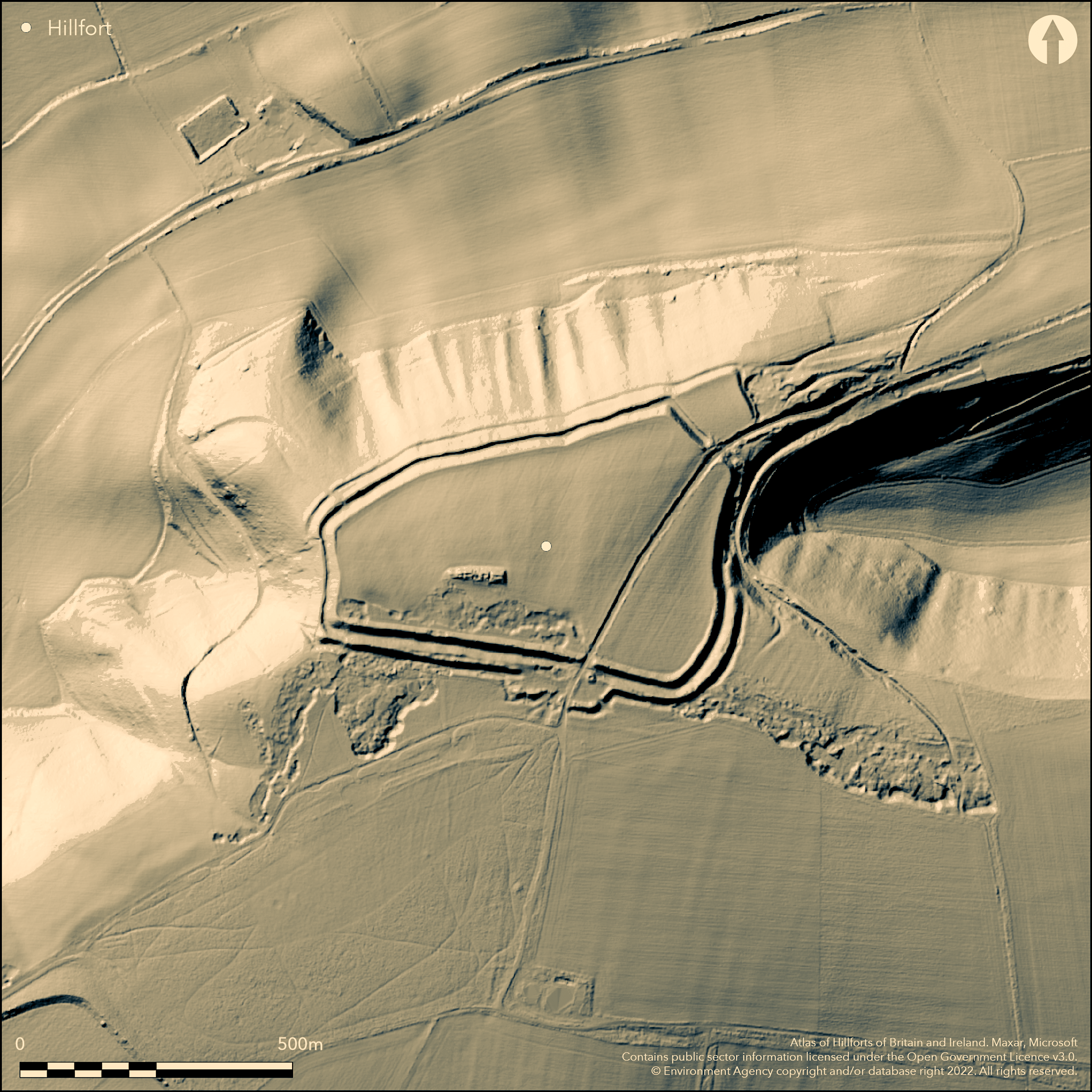
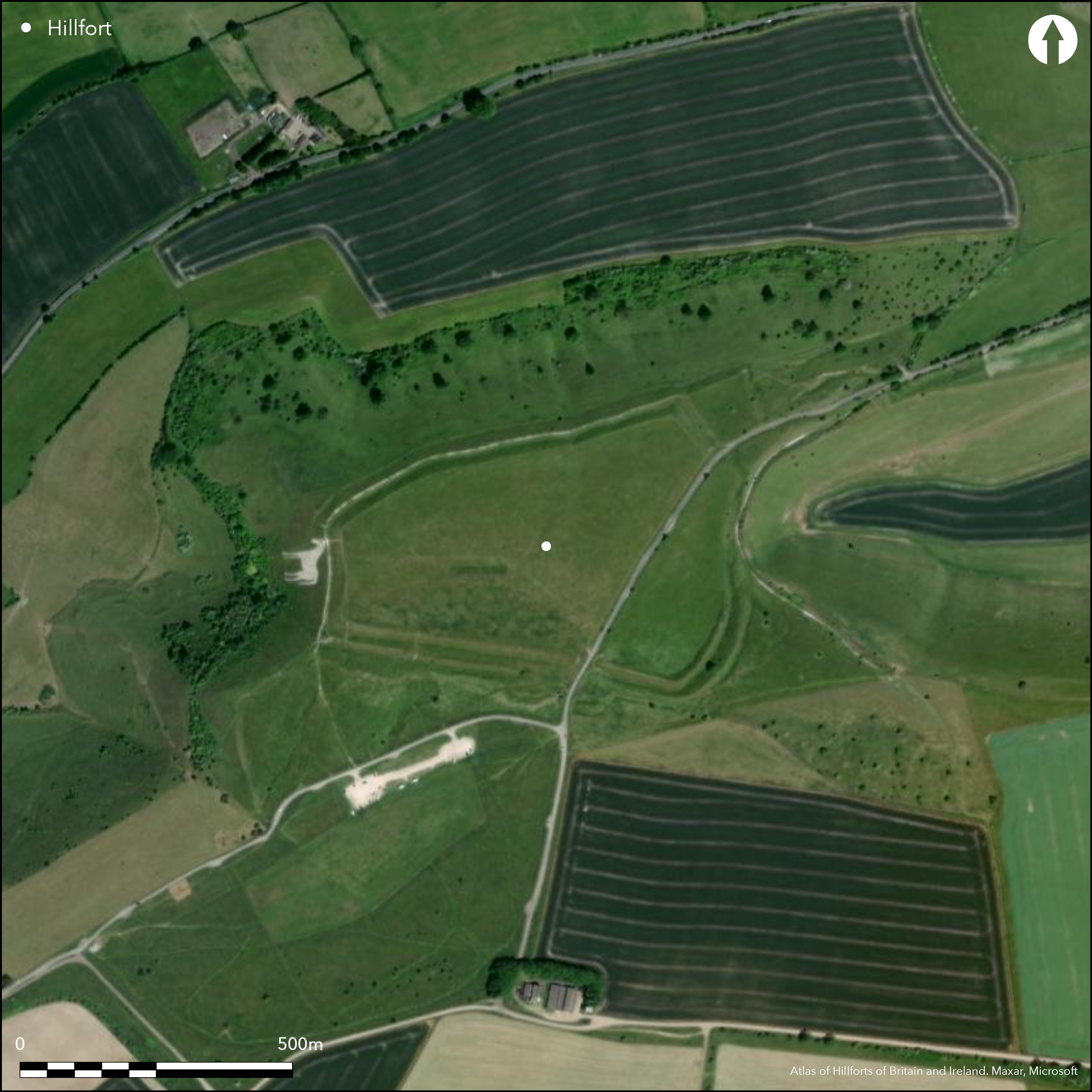
Bivallate contour hillfort located on Bratton Down at W edge of Salisbury Plain escarpment overlooking upper Avon valley. Precipitous slopes to N, very steep to W and level to moderate to S. Very steep sided combe on E. Two circuits of ditch and bank enclose a pentagonal area of 9.3ha, measuring internally 430m E-W by 120m at W end and 300m to E end. Short W side and the long N side stand on crest of steep escarpment slopes and ditches are stepped one above the other, the rampart slopes rising 5m and 6m above base of ditches, defences here 30m wide. S side of hillfort and S half of E side cross Bratton Down with two ramparts of about equal height and 30m wide. N half of the E side crosses head of a re-entrant valley where outer rampart and ditch much destroyed by quarrying, landslips and farm track. Short NE side straddles narrow steep-sided ridge up which runs the Port Way, passing through possible original entrance, here two ramparts separated to form small annexe, with outer ditch all but removed by quarrying. Port Way exits the fort on the S via another possible entrance. Quarrying also in interior. 'Excavated' by Jeffery Whittaker prior to 1775, one of the earliest archaeological investigations in Wiltshire. Little information as to what was found but possible odd sherds and quern stone. Roman and Saxon coins also found in vicinity. Excavation of fine Neolithic long barrow on summit of hill found two adult inhumations. Built in earthen tradition, with timber chamber at E end. Famous Westbury White Horse, hill figure, oldest of Wiltshire's white horses, first documented in 1742 and recut by Lord Abingdon in 1778, lies below W side of the hillfort. Downland pasture. On Ist Ed. OS map (1887).
Citizen Science: ✗
Reliability of Data: Confirmed
Reliability of Interpretation: Confirmed
X: -238560 Y: 6668083 (EPSG: 3857)
Longitude: -2.1430210289321154 Latitude: 51.263757389840464 (EPSG:4326)
Country: England
Current County or Unitary Authority: Wiltshire
Historic County: Wiltshire
Current Parish/Community/Council/Townland: Bratton
N half of the E side crosses head of re-entrant valley where the outer rampart and ditch have been largely destroyed by quarrying or landslips and the construction of farm track. Quarrying has, in the past, also taken place within parts of the interior.
| Extant | ✓ |
| Cropmark | ✗ |
| Likely Destroyed | ✗ |
Downland pasture. Quarrying.
| Woodland | ✗ |
| Commercial Forestry Plantation | ✗ |
| Parkland | ✗ |
| Pasture (Grazing) | ✓ |
| Arable | ✗ |
| Scrub/Bracken | ✗ |
| Bare Outcrop | ✗ |
| Heather/Moorland | ✗ |
| Heath | ✗ |
| Built-up | ✗ |
| Coastal Grassland | ✗ |
| Other | ✓ |
Bivallate, contour hillfort located on Bratton Down at the W edge of Salisbury Plain escarpment overlooking upper Avon valley. Precipitous slopes to N, very steep to W and level to moderate to S. Very steep sided combe on E.
| Contour Fort | ✓ |
| Partial Contour Fort | ✗ |
| Promontory Fort | ✗ |
| Hillslope Fort | ✗ |
| Level Terrain Fort | ✗ |
| Marsh Fort | ✗ |
| Multiple Enclosure Fort | ✗ |
Sited on a north-west facing downland spur
| Hilltop | ✗ |
| Coastal Promontory | ✗ |
| Inland Promontory | ✗ |
| Valley Bottom | ✗ |
| Knoll/Hillock/Outcrop | ✗ |
| Ridge | ✗ |
| Cliff/Plateau-edge/Scarp | ✓ |
| Hillslope | ✗ |
| Lowland | ✗ |
| Spur | ✓ |
Dominant Topographic Feature: Downland spur edge.
| North | ✗ |
| Northeast | ✗ |
| East | ✗ |
| Southeast | ✗ |
| South | ✗ |
| Southwest | ✗ |
| West | ✗ |
| Northwest | ✗ |
| Level | ✓ |
Altitude: 230.0m
N/A
Probably Iron Age based on morphology.
Reliability: D - None
| Pre 1200BC | ✗ |
| 1200BC - 800BC | ✗ |
| 800BC - 400BC | ✓ |
| 400BC - AD50 | ✓ |
| AD50 - AD400 | ✗ |
| AD400 - AD 800 | ✗ |
| Post AD800 | ✗ |
| Unknown | ✗ |
| Pre Hillfort: | None |
| Post Hillfort: | None |
| Morphology/Earthwork/Typology: | Estimated. |
In Aubrey's Monumenta Britannica (1665-1693). On Ist Ed. OS map (1887). Excavation by Jeffery Whittaker prior to 1775 - no details. RCHME field survey: Salisbury Plain Training Area, ref. no. 888341. 2004, 2007, 2010, various Watching Briefs for erection of fences and gate posts. 2004 revealed base of N rampart, otherwise 2007, 2010 no evidence of S entrance.
| 1st Identified Map Depiction (1887): | OS map. |
| 1st Identified Written Reference (None): | Aubrey's Monumenta Britannica. |
| Earthwork Survey (None): | RCHME field survey: Salisbury Plain Training Area. |
| Other (None): | Various Watching Briefs. |
| Excavation (None): | Jeffery Whittaker. |
Little information as to what was found in excavation, but possible odd sherds and quern stone. Roman and Saxon coins also found in vicinity. Neolithic long barrow excavated. Found two adult inhumations. Built in earthen tradition, with timber chamber at E end. Traces of side ditches visible.
None
| None | ✓ |
| Spring | ✗ |
| Stream | ✗ |
| Pool | ✗ |
| Flush | ✗ |
| Well | ✗ |
| Other | ✗ |
Neolithic long barrow.
| No Known Features | ✓ |
| Round Stone Structures | ✗ |
| Rectangular Stone Structures | ✗ |
| Curvilinear Platforms | ✗ |
| Other Roundhouse Evidence | ✗ |
| Pits | ✗ |
| Quarry Hollows | ✗ |
| Other | ✗ |
Excavation of fine Neolithic long barrow on summit of hill found two adult inhumations. Built in earthen tradition, with timber chamber at E end. Traces of side ditches visible.
| No Known Excavation | ✗ |
| Pits | ✗ |
| Postholes | ✗ |
| Roundhouses | ✗ |
| Rectangular Structures | ✗ |
| Roads/Tracks | ✗ |
| Quarry Hollows | ✗ |
| Other | ✓ |
| Nothing Found | ✗ |
None
| No Known Geophysics | ✓ |
| Pits | ✗ |
| Roundhouses | ✗ |
| Rectangular Structures | ✗ |
| Roads/Tracks | ✗ |
| Quarry Hollows | ✗ |
| Other | ✗ |
| Nothing Found | ✗ |
Little information as to what was found in excavation but possible odd sherds and quern stone. Roman and Saxon coins also found in vicinity.
| No Known Finds | ✗ |
| Pottery | ✓ |
| Metal | ✗ |
| Metalworking | ✗ |
| Human Bones | ✗ |
| Animal Bones | ✗ |
| Lithics | ✓ |
| Environmental | ✗ |
| Other | ✓ |
None
| APs Not Checked | ✓ |
| None | ✗ |
| Roundhouses | ✗ |
| Rectangular Structures | ✗ |
| Pits | ✗ |
| Postholes | ✗ |
| Roads/Tracks | ✗ |
| Other | ✗ |
Short NE side straddles narrow steep-sided ridge up which runs the Port Way, passing through possible original passageway entrance, here two ramparts separated to form small annexe, with outer ditch all but removed by quarrying. Port Way exits the fort on the S via another possible passageway entrance.
| 2: | None |
| 2: | None |
Guard Chambers: ✗
Chevaux de Frise: ✗
| 1. Passage-way/Corridor (North east): | Port Way passes through. |
| 2. Passage-way/Corridor (South): | Possible. Port Way passes through. |
Short W side and the long N side stand on crest of steep escarpment slopes and ditches are stepped one above the other, the rampart slopes rising 5m and 6m above base of ditches, defences here 30m wide. S side of hillfort and S half of E side cross Bratton Down with two ramparts of about equal height and 30m wide. N half of the E side crosses head of a re-entrant valley where outer rampart and ditch much destroyed by quarrying, landslips and farm track. Short NE side straddles narrow steep-sided ridge up which runs the Port Way, passing through possible original entrance. Here two ramparts separated to form small annexe, with outer ditch nearly removed by quarrying.
| Area 1: | 9.3ha. |
| Total: | 9.3ha. |
Total Footprint Area: Noneha.
None
| ✗ | None |
| ✓ | None |
| NE Quadrant: | 2 |
| SE Quadrant: | 2 |
| SW Quadrant: | 2 |
| NW Quadrant: | 2 |
| Total: | 2 |
| Partial Univallate | ✗ |
| Univallate | ✗ |
| Partial Bivallate | ✗ |
| Bivallate | ✓ |
| Partial Multivallate | ✗ |
| Multivallate | ✗ |
| Unknown | ✗ |
| Partial Univallate | ✗ |
| Univallate | ✗ |
| Partial Bivallate | ✗ |
| Bivallate | ✗ |
| Partial Multivallate | ✗ |
| Multivallate | ✗ |
None
| None | ✗ |
| Earthen Bank | ✓ |
| Stone Wall | ✗ |
| Rubble | ✗ |
| Wall-walk | ✗ |
| Evidence of Timber | ✗ |
| Vitrification | ✗ |
| Other Burning | ✗ |
| Palisade | ✗ |
| Counter Scarp Bank | ✗ |
| Berm | ✗ |
| Unfinished | ✗ |
| Other | ✗ |
None
| None | ✗ |
| Earthen Bank | ✗ |
| Stone Wall | ✗ |
| Murus Duplex | ✗ |
| Timber-framed | ✗ |
| Timber-laced | ✗ |
| Vitrification | ✗ |
| Other Burning | ✗ |
| Palisade | ✗ |
| Counter Scarp Bank | ✗ |
| Berm | ✗ |
| Unfinished | ✗ |
| No Known Excavation | ✓ |
| Other | ✗ |
| ✗ | None |
| ✓ | Two circuits of ditch damaged and lost in places. |
Number of Ditches: 2
| ✓ | Short NE side straddles narrow steep-sided ridge up which runs the Port Way, passing through possible original entrance. Here two ramparts separated to form small annexe, with outer ditch all but removed by quarrying. |
Cobham Resource Consultants 1989. Bratton Camp and Westbury white horse:, a report for English Heritage, 1-47.
Darvill, T., Stamper, P. and Timby, J. 2002. England an archaeological guide. Oxford: OUP, 378-79.
English Heritage 2004. Heritage Unlocked: Guide to free sites in Bristol, Gloucestershire and Wiltshire, English Heritage, 66-7.
Newman, P. 1997. Lost Gods of Albion. Stroud: Sutton Publishing.
Pugh, R.B. and Crittall, E. eds 1957. A history of Wiltshire, 1.1, The Victoria history of the counties of England, Oxford: OUP, 45, 263.
Atlas of Hillforts:
Wikidata:
This work is licensed under CC BY-SA 4.0![]()
![]()
![]() and should be cited as:
and should be cited as:
Lock, Gary and Ralston, Ian. 2024. Atlas of Hillforts of Britain and Ireland. Available at: https://hillforts.arch.ox.ac.uk
Document Version 1.1