LiDAR 1m DTM Hillshade
Satellite Imagery
LiDAR 1m DTM Hillshade
Satellite Imagery
Scroll left/right to view further images.
HER: Wiltshire and Swindon MWI (None)
NMR: SU 26 NE 5 (224649)
SM: 1013400
NGR: SU27896597
X: 427893 Y: 165971 (OSGB36)
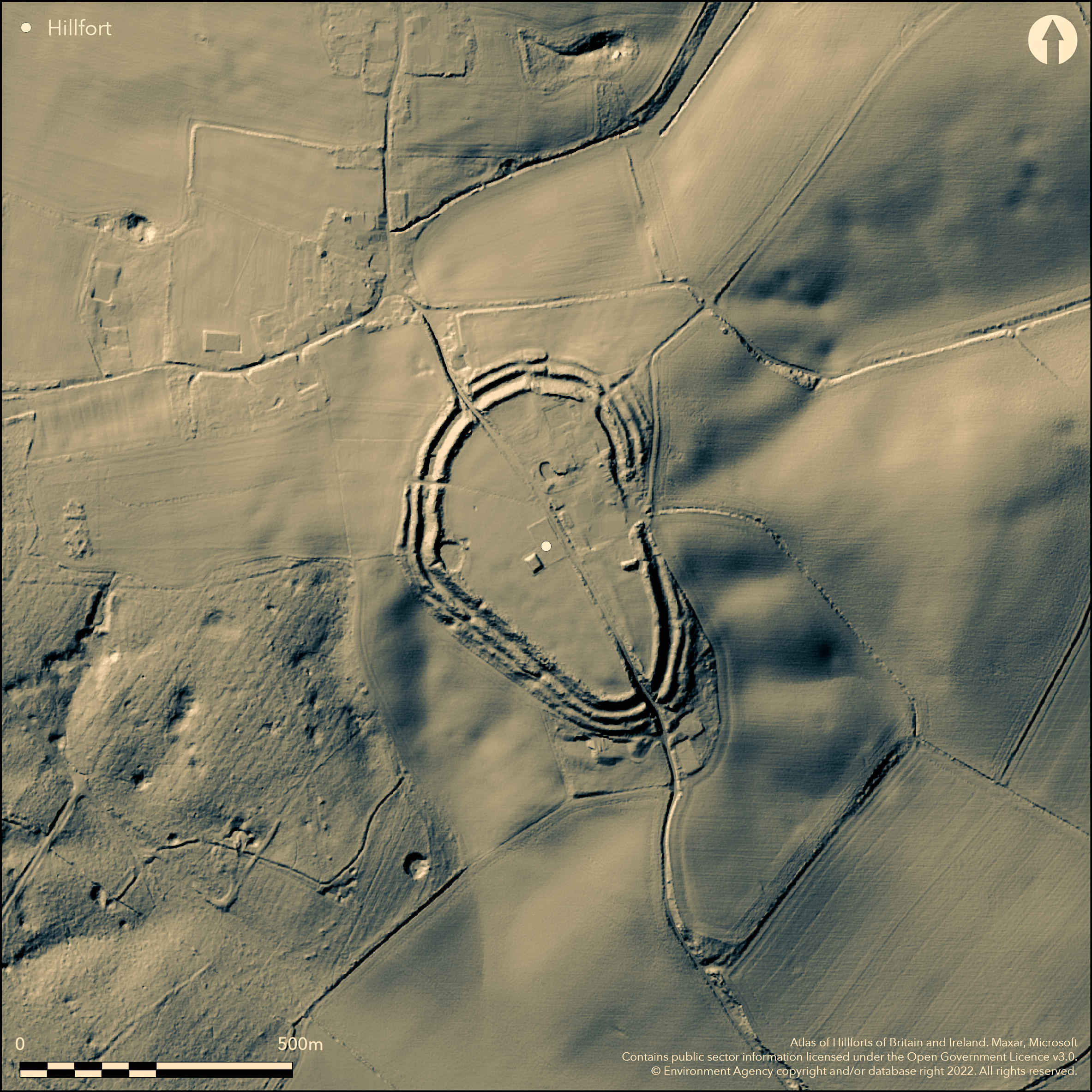
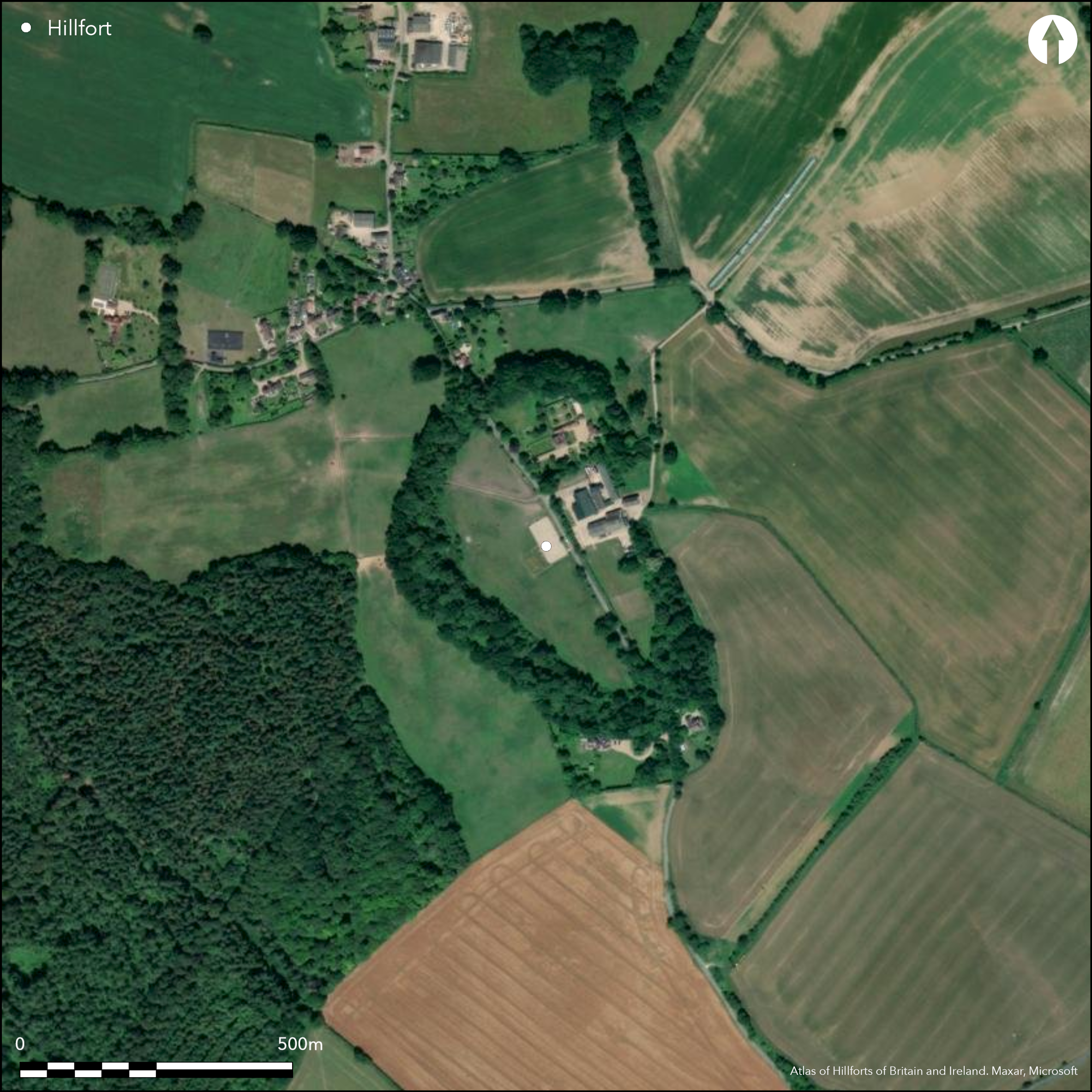
Remains of multivallate oval-shaped contour hillfort situated on low hill immediately S of Chisbury, enclosing 5.7ha. Remains medieval Chapel of St Martin lie on the E side of fort on line of defences and Manor Farm house located in the NE interior. Two, and in places three, circuits of ramparts, as spread banks to 0.3m in height and some over 50m in overall width. The external dimensions c. 450m NW-SE by 325m NE-SW. Bisected by modern road utilising gaps in the NW and SE sides, possibly through original entrances, especially that on the E which is shown on Andrews and Dury's map of 1773 with a hollow way leading to it. Ramparts also broken by several other gaps for access to the buildings which currently lie within fort; most to E of road, including the widest containing the chapel. Small excavation prior to building works. Chance finds of Iron Age pottery, urns, bronze swords, decorated harness mount. Possible storage pits. Recent finds from immediately outside the fort include coins and other objects of Roman date. The chapel interpreted as either chapel of ease to the parish church of Great Bedwyn or a free chapel of the Hampshire abbey of St Denys. Site generally well-preserved, despite buildings. On 1st Ed OS map (1877-82).
Citizen Science: ✗
Reliability of Data: Confirmed
Reliability of Interpretation: Confirmed
X: -178168 Y: 6690937 (EPSG: 3857)
Longitude: -1.6005122394142797 Latitude: 51.39204499896324 (EPSG:4326)
Country: England
Current County or Unitary Authority: Wiltshire
Historic County: Wiltshire
Current Parish/Community/Council/Townland: Little Bewyn
Remains medieval Chapel of St Martin lie on the E side of fort on line of defences and Manor Farm house located in the NE interior and road passes through site NW to SE. Despite this, generally well-preserved.
| Extant | ✓ |
| Cropmark | ✗ |
| Likely Destroyed | ✗ |
Pasture. Chapel remains, farmhouse and road.
| Woodland | ✗ |
| Commercial Forestry Plantation | ✗ |
| Parkland | ✗ |
| Pasture (Grazing) | ✓ |
| Arable | ✗ |
| Scrub/Bracken | ✗ |
| Bare Outcrop | ✗ |
| Heather/Moorland | ✗ |
| Heath | ✗ |
| Built-up | ✓ |
| Coastal Grassland | ✗ |
| Other | ✓ |
Remains of multivallate, oval-shape,d contour hillfort situated on low hill immediately S of Chisbury.
| Contour Fort | ✓ |
| Partial Contour Fort | ✗ |
| Promontory Fort | ✗ |
| Hillslope Fort | ✗ |
| Level Terrain Fort | ✗ |
| Marsh Fort | ✗ |
| Multiple Enclosure Fort | ✗ |
Downland site high above the River Kennet and east of Savernake Forest
| Hilltop | ✓ |
| Coastal Promontory | ✗ |
| Inland Promontory | ✗ |
| Valley Bottom | ✗ |
| Knoll/Hillock/Outcrop | ✗ |
| Ridge | ✗ |
| Cliff/Plateau-edge/Scarp | ✗ |
| Hillslope | ✗ |
| Lowland | ✗ |
| Spur | ✗ |
Dominant Topographic Feature: Low hill.
| North | ✗ |
| Northeast | ✗ |
| East | ✗ |
| Southeast | ✗ |
| South | ✗ |
| Southwest | ✗ |
| West | ✗ |
| Northwest | ✗ |
| Level | ✓ |
Altitude: 176.0m
N/A
Chance finds of late Iron Age pottery, silver coin of Verica, bronze swords? and decorated harness mount indicate late iron Age to Roman-British use of site.
Reliability: C - Low
| Pre 1200BC | ✗ |
| 1200BC - 800BC | ✗ |
| 800BC - 400BC | ✗ |
| 400BC - AD50 | ✓ |
| AD50 - AD400 | ✓ |
| AD400 - AD 800 | ✗ |
| Post AD800 | ✗ |
| Unknown | ✗ |
| Pre Hillfort: | None |
| Post Hillfort: | None |
| Artefactual: | Finds late Iron Age pottery, siver coin of Verica, bronze swords? and decorated harness mount. |
In Aubrey's Monumenta Britannica (1665-1693). Described by Colt Hoare 1819. On 1st Ed OS map (1877-82). On Shown on Andrews and Dury's map of Wiltshire 1773. 1931 laying of water pipe finds in interior. Prior building works excavation, Wiltshire Rescue Archaeology Project. English Heritage Savernake Forest NMP Project, 2001-08.
| 1st Identified Map Depiction (1773): | Andrew and Dury's Map of Wiltshire. |
| Other (1931): | Laying of water pipe finds. |
| Excavation (1988): | Prior building works, Wiltshire Rescue Archaeology Project. |
| 1st Identified Written Reference (None): | Aubrey's Monumenta Britannica. |
| Other (None): | OS map. |
| LiDAR Survey (None): | English Heritage Savernake Forest NMP Project. |
Small 1988 excavation for building works found post-medieval layers only. LiDar survey found trackway (visible as raised linear bank) in NW quadrant to NW entrance. In SE quadrant two banks, but whether Iron Age or later unclear. Finds late Iron Age pottery, silver coin of Verica, bronze swords and decorated harness mount. Possible storage pits.
None
| None | ✓ |
| Spring | ✗ |
| Stream | ✗ |
| Pool | ✗ |
| Flush | ✗ |
| Well | ✗ |
| Other | ✗ |
Possible storage pits, but unconfirmed.
| No Known Features | ✗ |
| Round Stone Structures | ✗ |
| Rectangular Stone Structures | ✗ |
| Curvilinear Platforms | ✗ |
| Other Roundhouse Evidence | ✗ |
| Pits | ✗ |
| Quarry Hollows | ✗ |
| Other | ✗ |
Small 1988 excavation for building works found post-medieval layers only.
| No Known Excavation | ✗ |
| Pits | ✗ |
| Postholes | ✗ |
| Roundhouses | ✗ |
| Rectangular Structures | ✗ |
| Roads/Tracks | ✗ |
| Quarry Hollows | ✗ |
| Other | ✓ |
| Nothing Found | ✗ |
None
| No Known Geophysics | ✓ |
| Pits | ✗ |
| Roundhouses | ✗ |
| Rectangular Structures | ✗ |
| Roads/Tracks | ✗ |
| Quarry Hollows | ✗ |
| Other | ✗ |
| Nothing Found | ✗ |
Chance finds late Iron Age pottery, siver coin of Verica, Possibly bronze swords and decorated harness mount. Water pipe laying 1931 found non-context Iron Age wheel-made bead rim and pre-Belgic pottery, early Iron Age sherds, and fragments of Samian ware bowl, long non-socketed spearhead (lost), two long swords and c. six urns.
| No Known Finds | ✗ |
| Pottery | ✓ |
| Metal | ✓ |
| Metalworking | ✗ |
| Human Bones | ✗ |
| Animal Bones | ✗ |
| Lithics | ✗ |
| Environmental | ✗ |
| Other | ✓ |
LiDar survey found trackway (visible as raised linear bank) in NW quadrant to NW entrance. In SE quadrant two banks, but whether Iron Age or later unclear. Possible storage pits?
| APs Not Checked | ✗ |
| None | ✗ |
| Roundhouses | ✗ |
| Rectangular Structures | ✗ |
| Pits | ✓ |
| Postholes | ✗ |
| Roads/Tracks | ✓ |
| Other | ✓ |
Bisected by modern road utilising gaps in the NW and SE sides, possibly through original entrances, especially that on the E which is shown on Andrews and Dury's map of 1773 with a hollow way leading to it.
| None: | Numerous total breaks in ramparts not determined. Ramparts broken by gaps for access to the buildings which currently lie within fort; most to E of road, including the widest containing the chapel. |
| 2: | None |
Guard Chambers: ✗
Chevaux de Frise: ✗
| 1. Simple Gap (North west): | None |
| 2. Simple Gap (South east): | None |
| 2. Hollow Way (South east): | Shown on Andrews and Dury's map of 1773 with a hollow way leading to it. |
Two, and in places three circuits of ramparts, as spread banks to 0.3m in height and some over 50m in overall width. The external dimensions c. 450m NW-SE by 325m NE-SW.
| Area 1: | 5.7ha. |
| Total: | 5.7ha. |
Total Footprint Area: Noneha.
None
| ✗ | None |
| ✗ | None |
| NE Quadrant: | 3 |
| SE Quadrant: | 2 |
| SW Quadrant: | 2 |
| NW Quadrant: | 3 |
| Total: | 3 |
| Partial Univallate | ✗ |
| Univallate | ✗ |
| Partial Bivallate | ✓ |
| Bivallate | ✗ |
| Partial Multivallate | ✓ |
| Multivallate | ✗ |
| Unknown | ✗ |
| Partial Univallate | ✗ |
| Univallate | ✗ |
| Partial Bivallate | ✗ |
| Bivallate | ✗ |
| Partial Multivallate | ✗ |
| Multivallate | ✗ |
None
| None | ✗ |
| Earthen Bank | ✓ |
| Stone Wall | ✗ |
| Rubble | ✗ |
| Wall-walk | ✗ |
| Evidence of Timber | ✗ |
| Vitrification | ✗ |
| Other Burning | ✗ |
| Palisade | ✗ |
| Counter Scarp Bank | ✗ |
| Berm | ✗ |
| Unfinished | ✗ |
| Other | ✗ |
None
| None | ✗ |
| Earthen Bank | ✗ |
| Stone Wall | ✗ |
| Murus Duplex | ✗ |
| Timber-framed | ✗ |
| Timber-laced | ✗ |
| Vitrification | ✗ |
| Other Burning | ✗ |
| Palisade | ✗ |
| Counter Scarp Bank | ✗ |
| Berm | ✗ |
| Unfinished | ✗ |
| No Known Excavation | ✓ |
| Other | ✗ |
| ✗ | None |
| ✓ | Number of ditches not determined excatly, but now buried features. Possibly three. |
Number of Ditches: 3
| ✗ | None |
Colt Hoare, R.C. 1819. The ancient history of Wiltshire, II, 13-14.
Crutchley S., Small F. and Bowden M. 2009. Savernake Forest: a report for the National Mapping Programme, Centre for Archaeology Report No 29-2009.
Pugh, R.B. and Crittall, E. eds 1957. A history of Wiltshire, 1.1, The Victoria history of the counties of England, Oxford: OUP, 83, 267.
Atlas of Hillforts:
Wikidata:
This work is licensed under CC BY-SA 4.0![]()
![]()
![]() and should be cited as:
and should be cited as:
Lock, Gary and Ralston, Ian. 2024. Atlas of Hillforts of Britain and Ireland. Available at: https://hillforts.arch.ox.ac.uk
Document Version 1.1