LiDAR 1m DTM Hillshade
Satellite Imagery
LiDAR 1m DTM Hillshade
Satellite Imagery
Scroll left/right to view further images.
HER: Wiltshire and Swindon MWI431956 (None)
NMR: SU 35 NW 3 (228452)
SM: 1005682
NGR: SU31955650
X: 431946 Y: 156527 (OSGB36)
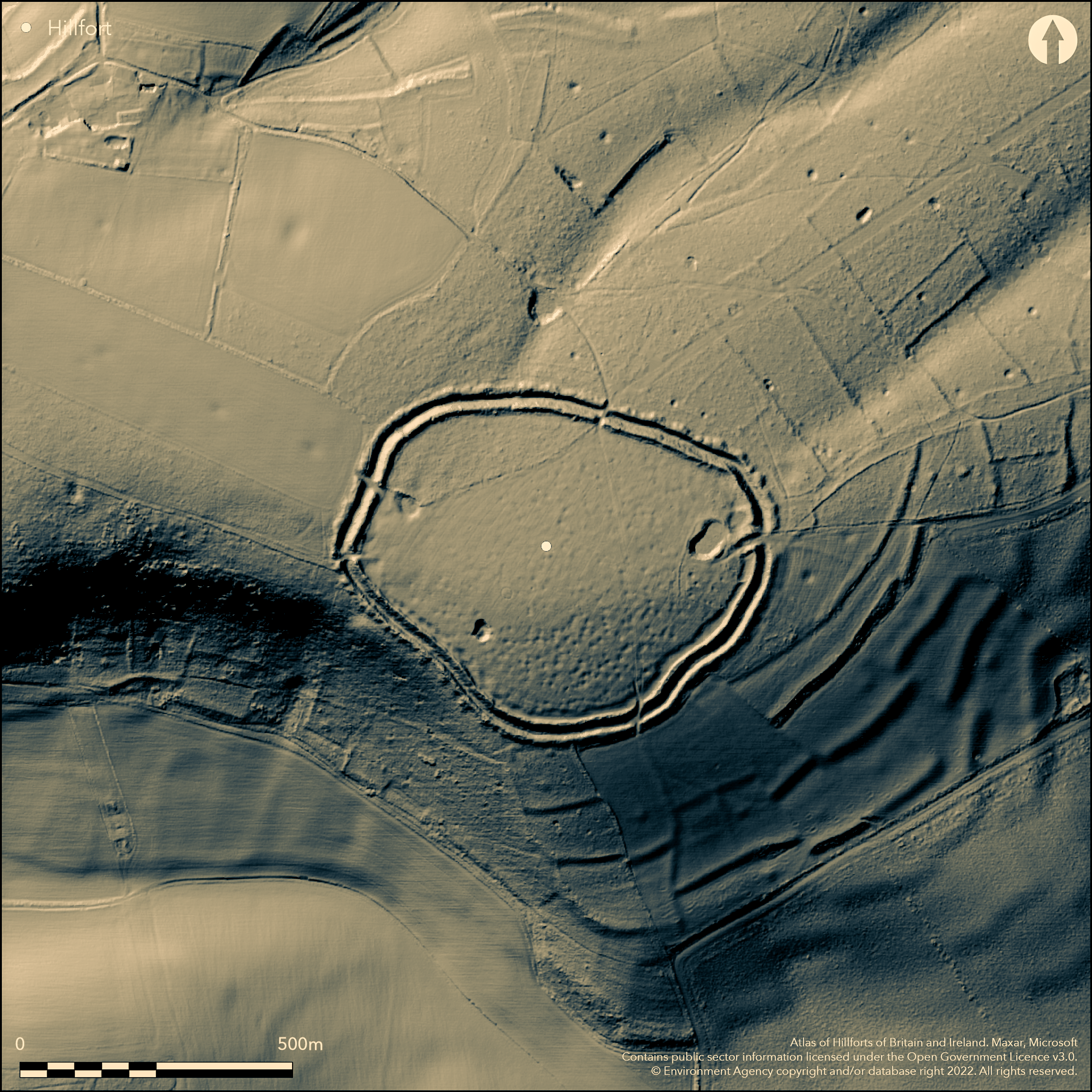
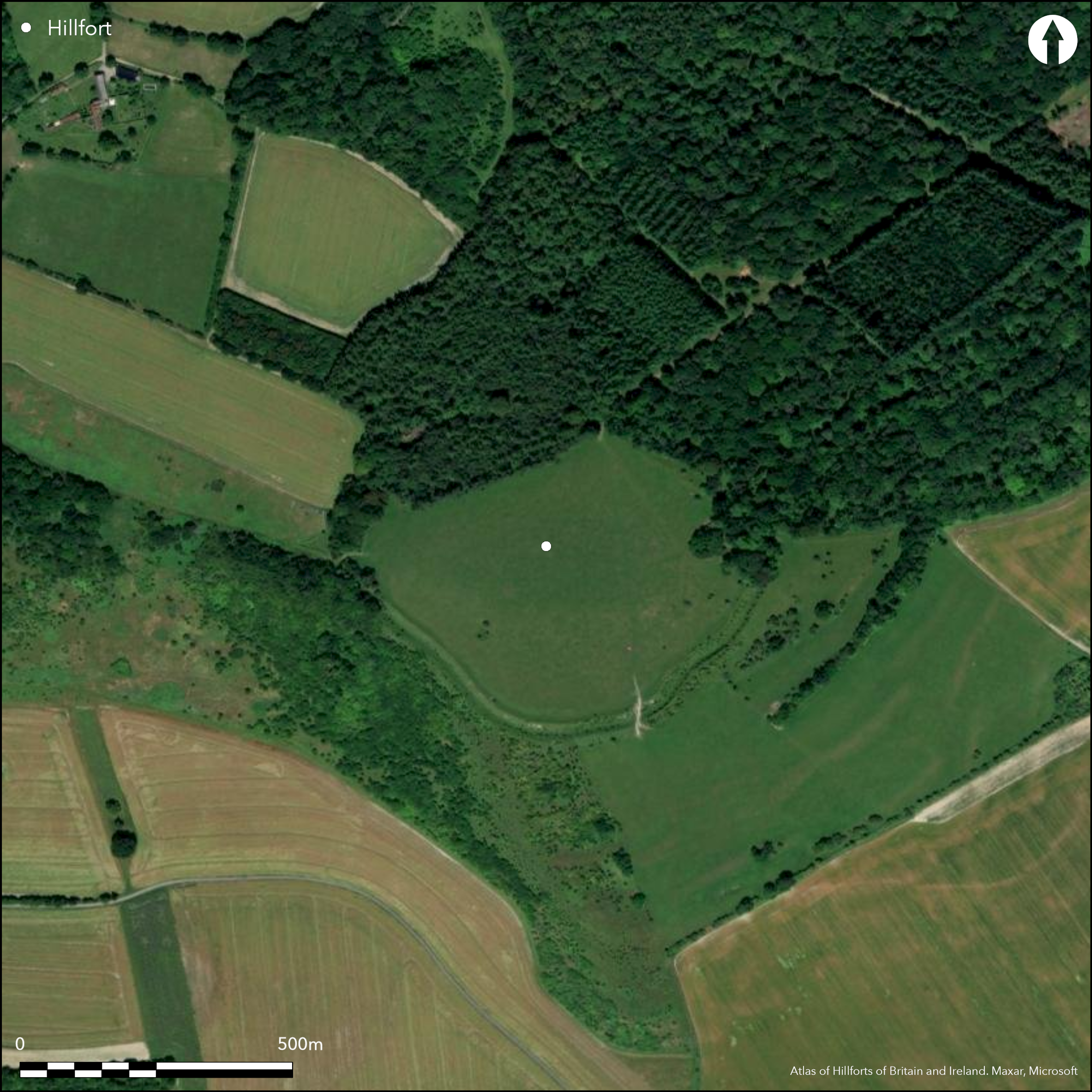
Large, univallate, partial contour hillfort, oval in plan, sited on S side of prominent downland ridge of Haydown Hill, with commanding views in all directions. Measures 430m by 330m, with interior area 10.5ha. Massive rampart, ditch and counterscarp, with interior quarry ditch on all S side. Fine inturned E entrance with four other indeterminate entrances. Surface evidence of hollows in interior, 1m to 4m in diameter and up to 0.5m deep, suggesting possible pits and or hut platforms as mapped by Ordnance Survey, but the geophysical survey showed little evidence apart from a few pits (Payne et al 2006). Fieldwork by Nichol 2001 found burnt flint, water worn pebble (perhaps slingstone), sherd of pottery of fine sandy fabric. Iron Age sherds found by Grinsell and Meyrick. Notable Celtic fields in vicinity and well-developed block of prehistoric fields, best on E and S slopes of hill, with lynchets seemingly overlain by hillfort counterscarp, so possibly pre-dating it. Site ploughed in past, but now permanent pasture. N ramparts wooded. On Ist Ed. OS map (1880).
Citizen Science: ✗
Reliability of Data: Confirmed
Reliability of Interpretation: Confirmed
X: -171778 Y: 6675764 (EPSG: 3857)
Longitude: -1.5431074601212689 Latitude: 51.30691533488524 (EPSG:4326)
Country: England
Current County or Unitary Authority: Wiltshire
Historic County: Wiltshire
Current Parish/Community/Council/Townland: Tidcombe and Fosbury
On Heritage at Risk Register (2015).
| Extant | ✓ |
| Cropmark | ✗ |
| Likely Destroyed | ✗ |
Site ploughed in past, but now permanent pasture. N ramparts wooded.
| Woodland | ✓ |
| Commercial Forestry Plantation | ✗ |
| Parkland | ✗ |
| Pasture (Grazing) | ✓ |
| Arable | ✓ |
| Scrub/Bracken | ✗ |
| Bare Outcrop | ✗ |
| Heather/Moorland | ✗ |
| Heath | ✗ |
| Built-up | ✗ |
| Coastal Grassland | ✗ |
| Other | ✗ |
Large, bivallate, partial contour hillfort, oval in plan, sited on S side of prominent downland ridge of Haydown HIll, with commanding views in all directions.
| Contour Fort | ✗ |
| Partial Contour Fort | ✓ |
| Promontory Fort | ✗ |
| Hillslope Fort | ✗ |
| Level Terrain Fort | ✗ |
| Marsh Fort | ✗ |
| Multiple Enclosure Fort | ✗ |
Downland hillslope fort facing south-east on Haydown Hill, very steeply sloping to the south-west and steeply sloping to the south-east.
| Hilltop | ✗ |
| Coastal Promontory | ✗ |
| Inland Promontory | ✗ |
| Valley Bottom | ✗ |
| Knoll/Hillock/Outcrop | ✗ |
| Ridge | ✓ |
| Cliff/Plateau-edge/Scarp | ✗ |
| Hillslope | ✗ |
| Lowland | ✗ |
| Spur | ✗ |
Dominant Topographic Feature: Prominent dowland ridge.
| North | ✗ |
| Northeast | ✗ |
| East | ✗ |
| Southeast | ✓ |
| South | ✗ |
| Southwest | ✗ |
| West | ✗ |
| Northwest | ✗ |
| Level | ✗ |
Altitude: 254.0m
N/A
Dating conjecture and no real evidence of date - Iron Age sherds found.
Reliability: C - Low
| Pre 1200BC | ✗ |
| 1200BC - 800BC | ✗ |
| 800BC - 400BC | ✗ |
| 400BC - AD50 | ✓ |
| AD50 - AD400 | ✗ |
| AD400 - AD 800 | ✗ |
| Post AD800 | ✗ |
| Unknown | ✗ |
| Pre Hillfort: | None |
| Post Hillfort: | None |
| Artefactual: | Iron Age sherds. |
On Ist Ed. OS map (1880). Geophysical survey as part of Wessex Hillfort Project 1996. Fieldwork and report by M. Nichol during 2001 gives the history of the site.
| 1st Identified Map Depiction (1880): | OS map. |
| Geophysical Survey (1996): | Wessex Hillforts Project. |
| Other (2001): | Fieldwork and report by M. Nichol. |
Quarry hollows along S side interior. Surface evidence of hollows in interior, 1m to 4m in diameter and up to 0.5m deep, possible pits and or hut platforms,as mapped by Ordnance Survey, but the geophysical survey showed little evidence apart from a few pits. Iron Age sherds, burnt flint, water-worn pebble (perhaps slingstone), sherd of pottery of fine sandy fabric.
Pond at E extremity of hillfort.
| None | ✗ |
| Spring | ✗ |
| Stream | ✗ |
| Pool | ✓ |
| Flush | ✗ |
| Well | ✗ |
| Other | ✗ |
Quarry hollows along S side interior. Surface evidence of hollows in interior, 1m to 4m in diameter and up to 0.5m deep, suggesting possible pits and or hut platforms as mapped by Ordnance Survey, but the geophysical survey showed little evidence apart from a few pits.
| No Known Features | ✗ |
| Round Stone Structures | ✗ |
| Rectangular Stone Structures | ✗ |
| Curvilinear Platforms | ✓ |
| Other Roundhouse Evidence | ✗ |
| Pits | ✓ |
| Quarry Hollows | ✓ |
| Other | ✓ |
None
| No Known Excavation | ✓ |
| Pits | ✗ |
| Postholes | ✗ |
| Roundhouses | ✗ |
| Rectangular Structures | ✗ |
| Roads/Tracks | ✗ |
| Quarry Hollows | ✗ |
| Other | ✗ |
| Nothing Found | ✗ |
Surface evidence of hollows in interior, 1m to 4m in diameter and up to 0.5m deep, suggesting possible pits and or hut platforms as mapped by Ordnance Survey, but the geophysical survey showed little evidence apart from a few pits.
| No Known Geophysics | ✗ |
| Pits | ✓ |
| Roundhouses | ✗ |
| Rectangular Structures | ✗ |
| Roads/Tracks | ✗ |
| Quarry Hollows | ✗ |
| Other | ✓ |
| Nothing Found | ✗ |
Iron Age sherds, burnt flint, water-worn pebble (perhaps slingstone), sherd of pottery of fine sandy fabric.
| No Known Finds | ✗ |
| Pottery | ✓ |
| Metal | ✗ |
| Metalworking | ✗ |
| Human Bones | ✗ |
| Animal Bones | ✗ |
| Lithics | ✓ |
| Environmental | ✗ |
| Other | ✗ |
None
| APs Not Checked | ✓ |
| None | ✗ |
| Roundhouses | ✗ |
| Rectangular Structures | ✗ |
| Pits | ✗ |
| Postholes | ✗ |
| Roads/Tracks | ✗ |
| Other | ✗ |
One fine definite original inturned entrance on E. Other four gaps indeterminate.
| 5: | Four gaps indeterminate, with three possible modern gaps on N and W, but that on NW may be original, but much disturbed. |
| 2: | One definite original entrance on E. That to S with staggered entrance passage formed by offset rampart terminals |
Guard Chambers: ✗
Chevaux de Frise: ✗
| 1. In-turned (East): | Original with well-developed inturns. |
| 2. Oblique (South): | Possibly original staggered entrance formed by offset rampart terminals. |
| 3. Passage-way/Corridor (North west): | Possible only. |
Massive rampart, ditch and counterscarp with interior quarry ditch on all sides.
| Area 1: | 10.5ha. |
| Total: | 10.5ha. |
Total Footprint Area: Noneha.
None
| ✗ | None |
| ✓ | None |
| NE Quadrant: | 1 |
| SE Quadrant: | 1 |
| SW Quadrant: | 1 |
| NW Quadrant: | 1 |
| Total: | 1 |
| Partial Univallate | ✗ |
| Univallate | ✓ |
| Partial Bivallate | ✗ |
| Bivallate | ✗ |
| Partial Multivallate | ✗ |
| Multivallate | ✗ |
| Unknown | ✗ |
| Partial Univallate | ✗ |
| Univallate | ✗ |
| Partial Bivallate | ✗ |
| Bivallate | ✗ |
| Partial Multivallate | ✗ |
| Multivallate | ✗ |
Substantial counterscarp bank, sometimes interpreted, wrongly, as second rampart.
| None | ✗ |
| Earthen Bank | ✓ |
| Stone Wall | ✗ |
| Rubble | ✗ |
| Wall-walk | ✗ |
| Evidence of Timber | ✗ |
| Vitrification | ✗ |
| Other Burning | ✗ |
| Palisade | ✗ |
| Counter Scarp Bank | ✓ |
| Berm | ✗ |
| Unfinished | ✗ |
| Other | ✗ |
None
| None | ✗ |
| Earthen Bank | ✗ |
| Stone Wall | ✗ |
| Murus Duplex | ✗ |
| Timber-framed | ✗ |
| Timber-laced | ✗ |
| Vitrification | ✗ |
| Other Burning | ✗ |
| Palisade | ✗ |
| Counter Scarp Bank | ✗ |
| Berm | ✗ |
| Unfinished | ✗ |
| No Known Excavation | ✓ |
| Other | ✗ |
| ✓ | Possible evidence. Rampart constructed in short, straight lengths, with marked changes of alignment (Payne at al 2006, 112). |
| ✓ | None |
Number of Ditches: 1
| ✗ | None |
Colt Hoare, R.C. 1812. The ancient history of Wiltshire, 1, London: Miller, 250.
Nichol, M. 2001. An archaeological study of Fosbury hillfort, Accession Register: Devises Museum.
Payne, A., Corney, M. and Cunliffe, B. 2006. The Wessex Hillforts Project. Extensive survey of hillfort interiors in Cenral Southern England, London: English Heritage, 107-10.
Pugh, R.B. and Crittall, E. eds 1957. A history of Wiltshire, 1.1, The Victoria history of the counties of England, Oxford: OUP, 113, 270.
Atlas of Hillforts:
Wikidata:
This work is licensed under CC BY-SA 4.0![]()
![]()
![]() and should be cited as:
and should be cited as:
Lock, Gary and Ralston, Ian. 2024. Atlas of Hillforts of Britain and Ireland. Available at: https://hillforts.arch.ox.ac.uk
Document Version 1.1