LiDAR 1m DTM Hillshade
Satellite Imagery
LiDAR 1m DTM Hillshade
Satellite Imagery
Scroll left/right to view further images.
HER: Wiltshire and Swindon MWI2303 (None)
NMR: ST 87 SW 4 (208476)
SM: 1018385
NGR: ST81817396
X: 381814 Y: 173960 (OSGB36)
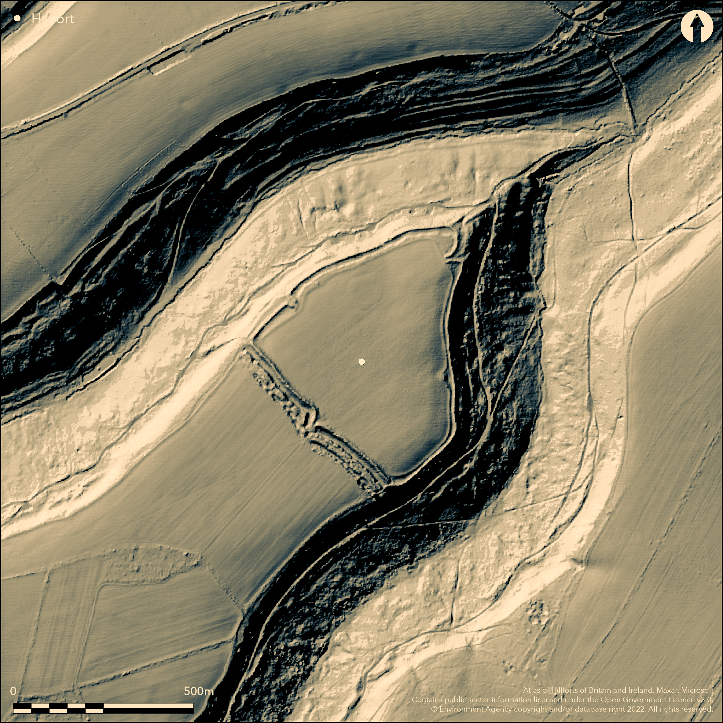
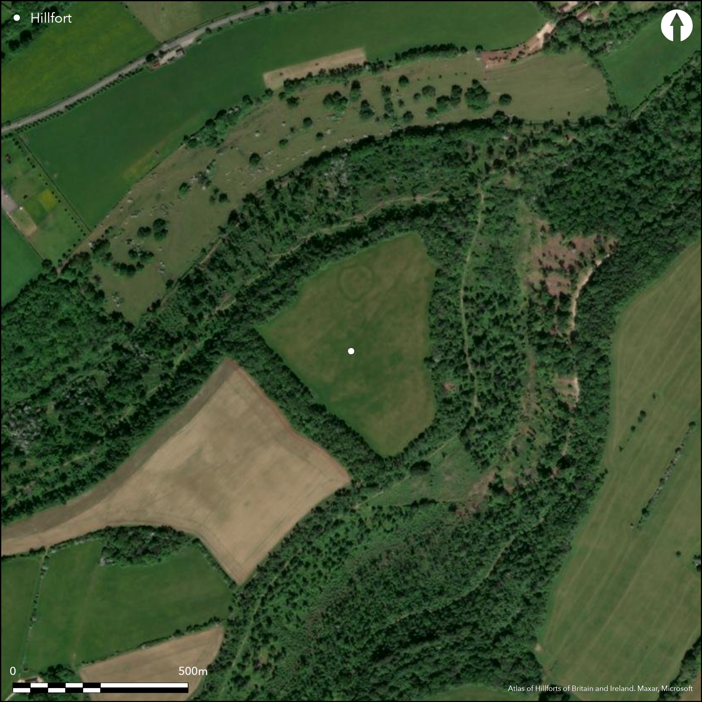
Sub-triangular, multivallate, partial contour hillfort located on NE-facing slightly rounded spur promontory between two wooded stream valleys (Doncombe Bottom and Sewell Wood) of Colerne Down at S edge of Cotswold Hills. Very steep wooded surrounding slopes to W, steep on N and E, level/moderate along ridge corridor to SW. Open interior with wooded ramparts. Often called a promontory fort, defences form a circuit, 9.2ha enclosed, bivallate on SW side where no natural defence and a partial contour fort preferred. Early earthwork survey by Shaw Mellor (1936). Enclosure surrounded by ditch 4m wide up to 1m deep and outer bank to 1.5m high on E and NW sides and to 2m high on SW across neck of the promontory where there are no natural defences. Here further ditch 4m wide and 1m deep and outer bank to 2m high and 3m wide. At NE corner inner bank turns inwards to form funnel-shaped entrance. Another entrance about quarter of way along NW side consists of inward turning ramparts forming another funnel-shaped entrance, possible blocked early entrance at W suggested by excavation. Both entrances have stone-faced ramparts and gate posts. Small enclosure within interior visible on aerial photographs confirmed by excavation. Series of excavations by Grant King (1961-69). Material culture includes pottery, rotary and saddle querns, sling stones, loom weights, iron and bronze objects. Also flint artefacts including scrapers, cores and flakes. Excavation suggests pre-hillfort Iron Age occupation, two phases of rampart the first destroyed by fire, end of occupation c. 2nd century BC. On Ist Ed. OS map (1886).
Citizen Science: ✓
Reliability of Data: Confirmed
Reliability of Interpretation: Confirmed
X: -251938 Y: 6703831 (EPSG: 3857)
Longitude: -2.2631992089135804 Latitude: 51.464265661864 (EPSG:4326)
Country: England
Current County or Unitary Authority: Wiltshire
Historic County: Wiltshire
Current Parish/Community/Council/Townland: Colerne
Good condition.
| Extant | ✓ |
| Cropmark | ✗ |
| Likely Destroyed | ✗ |
Open interior with wooded ramparts.
| Woodland | ✓ |
| Commercial Forestry Plantation | ✗ |
| Parkland | ✗ |
| Pasture (Grazing) | ✓ |
| Arable | ✗ |
| Scrub/Bracken | ✗ |
| Bare Outcrop | ✗ |
| Heather/Moorland | ✗ |
| Heath | ✗ |
| Built-up | ✗ |
| Coastal Grassland | ✗ |
| Other | ✗ |
Sub-triangular, multivallate, partial contour hillfort located on NE-facing slightly rounded spur promontory between two wooded stream valleys (Doncombe Bottom and Sewell Wood) of Colerne Down at S edge of Cotswold Hills. Very steep wooded surrounding slopes to W, steep on N and E, level/moderate along ridge corridor to SW.
| Contour Fort | ✗ |
| Partial Contour Fort | ✓ |
| Promontory Fort | ✗ |
| Hillslope Fort | ✗ |
| Level Terrain Fort | ✗ |
| Marsh Fort | ✗ |
| Multiple Enclosure Fort | ✗ |
Downland site very steeply sloping to the north, east and south
| Hilltop | ✗ |
| Coastal Promontory | ✗ |
| Inland Promontory | ✓ |
| Valley Bottom | ✗ |
| Knoll/Hillock/Outcrop | ✗ |
| Ridge | ✗ |
| Cliff/Plateau-edge/Scarp | ✗ |
| Hillslope | ✗ |
| Lowland | ✗ |
| Spur | ✓ |
Dominant Topographic Feature: Spur promontory
| North | ✗ |
| Northeast | ✓ |
| East | ✗ |
| Southeast | ✗ |
| South | ✗ |
| Southwest | ✗ |
| West | ✗ |
| Northwest | ✗ |
| Level | ✗ |
Altitude: 140.0m
N/A
Artefacts and stratigraphical sequence from excavation. Excavation suggests pre-hillfort Iron Age occupation, two phases of rampart the first destroyed by fire, end of occupation c. 2nd century BC.
Reliability: B - Medium
| Pre 1200BC | ✗ |
| 1200BC - 800BC | ✗ |
| 800BC - 400BC | ✓ |
| 400BC - AD50 | ✓ |
| AD50 - AD400 | ✗ |
| AD400 - AD 800 | ✗ |
| Post AD800 | ✗ |
| Unknown | ✗ |
| Pre Hillfort: | None |
| Post Hillfort: | None |
| Artefactual: | None |
In Aubrey's Monumenta Britannica (1665-1693). On Ist Ed. OS map (1886). Earthwork survey (Shaw Miller 1936), excavations 1959-1969 (Grant King). RCHME survey, ref. no. 901061.
| 1st Identified Map Depiction (1886): | OS map. |
| Earthwork Survey (1936): | A. Shaw Miller. |
| 1st Identified Written Reference (None): | Aubrey's Monumenta Britannica. |
| Excavation (None): | D. Grant King. |
| Earthwork Survey (None): | RCHME. |
Quarry hollows. Small enclosure within interior visible on aerial photographs. Pottery, rotary and saddle querns, sling stones, loom weights, iron and bronze objects recovered from excavation. Also flint artefacts including scrapers, cores and flakes.
None
| None | ✓ |
| Spring | ✗ |
| Stream | ✗ |
| Pool | ✗ |
| Flush | ✗ |
| Well | ✗ |
| Other | ✗ |
None
| No Known Features | ✗ |
| Round Stone Structures | ✗ |
| Rectangular Stone Structures | ✗ |
| Curvilinear Platforms | ✗ |
| Other Roundhouse Evidence | ✗ |
| Pits | ✗ |
| Quarry Hollows | ✓ |
| Other | ✗ |
Excavation suggests pre-hillfort Iron Age occupation, two phases of rampart the first destroyed by fire, end of occupation c. 2nd century BC.
| No Known Excavation | ✗ |
| Pits | ✗ |
| Postholes | ✗ |
| Roundhouses | ✗ |
| Rectangular Structures | ✗ |
| Roads/Tracks | ✗ |
| Quarry Hollows | ✗ |
| Other | ✓ |
| Nothing Found | ✗ |
None
| No Known Geophysics | ✓ |
| Pits | ✗ |
| Roundhouses | ✗ |
| Rectangular Structures | ✗ |
| Roads/Tracks | ✗ |
| Quarry Hollows | ✗ |
| Other | ✗ |
| Nothing Found | ✗ |
Pottery, rotary and saddle querns, sling stones, loom weights, iron and bronze objects. Also flint artefacts including scrapers, cores and flakes.
| No Known Finds | ✗ |
| Pottery | ✓ |
| Metal | ✓ |
| Metalworking | ✗ |
| Human Bones | ✗ |
| Animal Bones | ✗ |
| Lithics | ✓ |
| Environmental | ✗ |
| Other | ✓ |
Small enclosure within interior visible on aerial photographs.
| APs Not Checked | ✗ |
| None | ✗ |
| Roundhouses | ✗ |
| Rectangular Structures | ✗ |
| Pits | ✗ |
| Postholes | ✗ |
| Roads/Tracks | ✗ |
| Other | ✓ |
At NE corner inner bank turns inwards to form funnel-shaped entrance. Another entrance about quarter of way along NW side consists of inward turning ramparts forming another funnel-shaped entrance. Break at the W appears modern, but excavation suggests it may be a blocked early entrance.
| 3: | None |
| 2: | None |
Guard Chambers: ✗
Chevaux de Frise: ✗
| 1. In-turned (North east): | Bank turns inwards to form funnel-shaped entrance. |
| 2. In-turned (North west): | Bank turns inwards to form funnel-shaped entrance. |
| 3. Blocked (West): | Break at the W appears modern, but excavation suggests it may be a blocked early entrance. |
Enclosure surrounded by ditch 4m wide up to 1m deep and outer bank to 1.5m high on E and NW sides and to 2m high on SW across neck of the promontory where there are no natural defences. Here further ditch 4m wide and 1m deep and outer bank to 2m high and 3m wide.
| Area 1: | 9.2ha. |
| Total: | 9.2ha. |
Total Footprint Area: Noneha.
None
| ✓ | Excavation suggests pre-hillfort Iron Age occupation, two phases of rampart the first destroyed by fire, end of occupation c. 2nd century BC. |
| ✓ | None |
| NE Quadrant: | 1 |
| SE Quadrant: | 1 |
| SW Quadrant: | 2 |
| NW Quadrant: | 1 |
| Total: | 2 |
| Partial Univallate | ✓ |
| Univallate | ✗ |
| Partial Bivallate | ✓ |
| Bivallate | ✗ |
| Partial Multivallate | ✗ |
| Multivallate | ✗ |
| Unknown | ✗ |
| Partial Univallate | ✗ |
| Univallate | ✓ |
| Partial Bivallate | ✗ |
| Bivallate | ✗ |
| Partial Multivallate | ✗ |
| Multivallate | ✗ |
None
| None | ✗ |
| Earthen Bank | ✓ |
| Stone Wall | ✗ |
| Rubble | ✗ |
| Wall-walk | ✗ |
| Evidence of Timber | ✗ |
| Vitrification | ✗ |
| Other Burning | ✗ |
| Palisade | ✗ |
| Counter Scarp Bank | ✗ |
| Berm | ✗ |
| Unfinished | ✗ |
| Other | ✗ |
Excavation suggests pre-hillfort Iron Age occupation, two phases of rampart the first destroyed by fire, end of occupation c. 2nd century BC.
| None | ✗ |
| Earthen Bank | ✓ |
| Stone Wall | ✓ |
| Murus Duplex | ✗ |
| Timber-framed | ✗ |
| Timber-laced | ✗ |
| Vitrification | ✗ |
| Other Burning | ✓ |
| Palisade | ✗ |
| Counter Scarp Bank | ✗ |
| Berm | ✗ |
| Unfinished | ✗ |
| No Known Excavation | ✗ |
| Other | ✗ |
| ✗ | None |
| ✓ | Two ditches on SW, one elsewhere. |
Number of Ditches: 2
| ✗ | None |
Grant King, D. 1961. Bury Wood Camp, report on excavations, 1959. Wiltshire Archael Natur Hist Mag, 58, 40-7.
Grant King, D. 1962. Bury Wood Camp, report on excavations, 1960. Wiltshire Archael Natur Hist Mag, 58, 185-206.
Grant King, D. 1967. Bury Wood Camp. Excavations in the area of the south-west opening. Wiltshire Archael Natur Hist Mag, 62, 1-15.
Grant King, D. 1969. Bury Wood Camp. Excavations in the north-east and north-west areas. Wiltshire Archael Natur Hist Mag, 64, 21-50.
Pugh, R.B. and Crittall, E. eds 1957. A history of Wiltshire, 1.1, The Victoria history of the counties of England, Oxford: OUP, 59, 264.
Shaw Mellor, A. 1936. Notes on Bury Wood Camp, Colerne, Wilts. Wiltshire Archael Natur Hist Mag,47, 504-12.
Atlas of Hillforts:
Wikidata:
This work is licensed under CC BY-SA 4.0![]()
![]()
![]() and should be cited as:
and should be cited as:
Lock, Gary and Ralston, Ian. 2024. Atlas of Hillforts of Britain and Ireland. Available at: https://hillforts.arch.ox.ac.uk
Document Version 1.1