LiDAR 1m DTM Hillshade
Satellite Imagery
LiDAR 1m DTM Hillshade
Satellite Imagery
Scroll left/right to view further images.
HER: Wiltshire and Swindon MWI2691 (None)
NMR: ST 92 NE 1 (210306)
SM: 1005701
NGR: ST96362837
X: 396362 Y: 128373 (OSGB36)
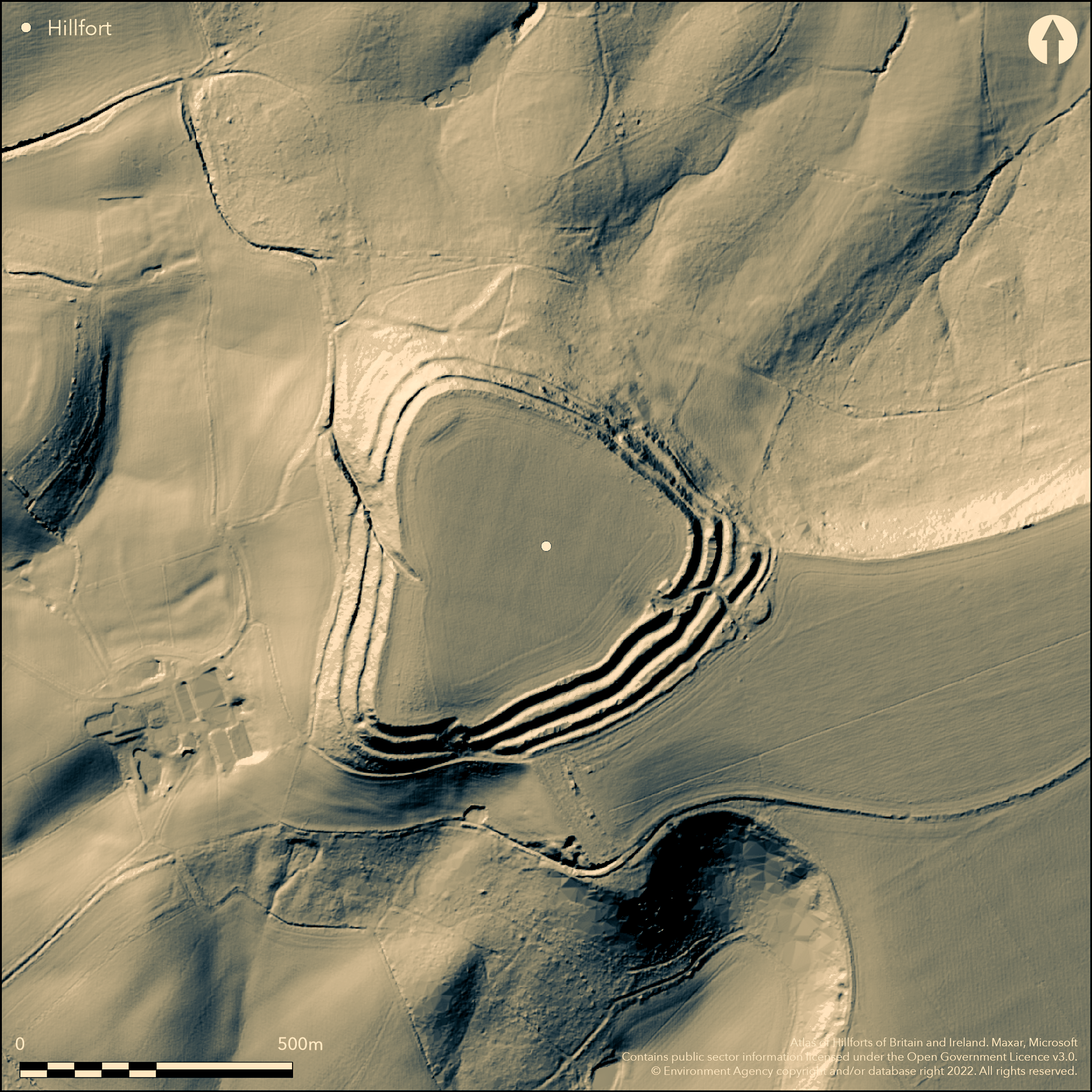
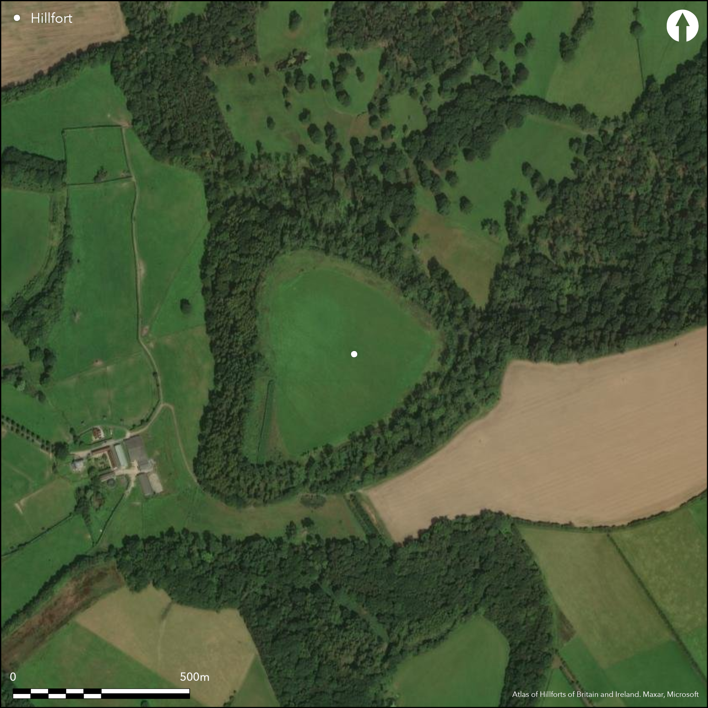
Large, multivallate, partial contour hillfort located on gentle SE-facing slope of Greensand promontory with commanding views over Nadder Valley. Topography has determined its triangular shape, with very steep surrounding slopes to NW, NE and SW and a gradual sloping narrow neck of level ground to the SE. The fort measures 500m NE to SW, by 480m NW-SE, and 17.5ha in extent overall, 9.7ha interior. On the promontory three ramparts, up to 10m high, with no trace of internal bank along the crest, with two intervening ditches, max. 1.5m deep, or as terraces. Across neck of promontory to SE, three massive banks and external ditches 75m wide in total; individual rampart crests up to 7.5m high above ditch bottoms. Outer rampart, in part, has a berm c. 3m wide, lying 1.4m below rampart crest, on inner side, suggested to provide access for defence on this, the most vulnerable flank, but this is pure conjecture. Breaks in outer rampart's crest may indicate unfinished state. Two original major entrances and possibly a further two simpler ones. Damaged entrance on E (at Red Barn), hollow way, 10m wide, 1m deep and now c. 50m winding passage, between middle and outer ramparts, which serve as hornwork, with additional outer bank and ditch. Middle and inner ramparts crossed through simple, staggered, gaps. W entrance and narrow covered way, 290m long max. 6m deep, crossing ramparts obliquely. Band below ramparts gives protection on lower side. Simple break in NE in middle possibly original entrance, upper rampart slightly inturned. To S another possible entrance, but badly affected by farm use. Narrow gap in the middle rampart at SW angle possibly original, but use uncertain as no visible breaks in upper or lower ramparts. Geophysics (Payne et al 2006) shows between 20 and 50 roundhouses, 10m-15m diameter, in the N half of the hillfort arranged in lines. Possibly a later phase represented by a series of irregularly shaped ditched enclosures. Pits scattered across the whole site. Finds of haematite pottery suggest an early Iron Age date, with possible multi phases of sustained occupation, and quarry hollows possibly characteristic of middle to late Iron Age phases of development. Possible long barrow on summit. General good condition although interior cultivated and ramparts heavily wooded. A fine and somewhat neglected hillfort at risk. On Ist Ed. OS map (1887).
Citizen Science: ✗
Reliability of Data: Confirmed
Reliability of Interpretation: Confirmed
X: -228573 Y: 6630963 (EPSG: 3857)
Longitude: -2.0533018267615923 Latitude: 51.054629613132015 (EPSG:4326)
Country: England
Current County or Unitary Authority: Wiltshire
Historic County: Wiltshire
Current Parish/Community/Council/Townland: Tisbury
Generally good condition, but interior cultivated and ploughed-out quarry and covered reservoir built against inner rampart. S entrance damaged. On Heritage at Risk Register (2015).
| Extant | ✓ |
| Cropmark | ✗ |
| Likely Destroyed | ✗ |
Pasture interior. Heavily wooded ramparts and surrounding slopes. SW replanted with conifers. Quarry and covered reservoir built against inner rampart.
| Woodland | ✓ |
| Commercial Forestry Plantation | ✗ |
| Parkland | ✗ |
| Pasture (Grazing) | ✓ |
| Arable | ✗ |
| Scrub/Bracken | ✗ |
| Bare Outcrop | ✗ |
| Heather/Moorland | ✗ |
| Heath | ✗ |
| Built-up | ✗ |
| Coastal Grassland | ✗ |
| Other | ✓ |
Large, multivallate, partial contour hillfort of 9.7 ha located on gentle SE-facing slope of Greensand promontory with commanding views over Nadder Valley. Topography has determined its triangular shape, with very steep surrounding slopes to NW, NE and SW and a gradual sloping narrow neck of level ground to the SE.
| Contour Fort | ✗ |
| Partial Contour Fort | ✓ |
| Promontory Fort | ✗ |
| Hillslope Fort | ✗ |
| Level Terrain Fort | ✗ |
| Marsh Fort | ✗ |
| Multiple Enclosure Fort | ✗ |
Downland hillfort located above te River Nadder in the Vale of Wardour
| Hilltop | ✗ |
| Coastal Promontory | ✗ |
| Inland Promontory | ✓ |
| Valley Bottom | ✗ |
| Knoll/Hillock/Outcrop | ✗ |
| Ridge | ✗ |
| Cliff/Plateau-edge/Scarp | ✗ |
| Hillslope | ✗ |
| Lowland | ✗ |
| Spur | ✗ |
Dominant Topographic Feature: Greensand escarpment.
| North | ✗ |
| Northeast | ✗ |
| East | ✗ |
| Southeast | ✗ |
| South | ✗ |
| Southwest | ✗ |
| West | ✗ |
| Northwest | ✗ |
| Level | ✓ |
Altitude: 193.0m
N/A
Finds of haematite pottery suggest early Iron Age date. Possible multi- phases of sustained occupation. Quarry hollows possibly characteristic of middle to late Iron Age phases of development.
Reliability: C - Low
| Pre 1200BC | ✗ |
| 1200BC - 800BC | ✗ |
| 800BC - 400BC | ✓ |
| 400BC - AD50 | ✓ |
| AD50 - AD400 | ✗ |
| AD400 - AD 800 | ✗ |
| Post AD800 | ✗ |
| Unknown | ✗ |
| Pre Hillfort: | None |
| Post Hillfort: | None |
| Artefactual: | Haematite pottery. |
| Morphology/Earthwork/Typology: | Quarry hollows. |
In Aubrey's Monumenta Britannica (1665-1693). On Ist Ed. OS map (1887). Repair work undertaken by Wessex Archaeology in 1989 recorded partial section of inner ditch and part of outer bank. Partial section of S defences recorded by Wessex Archaeology after a landslip (Fielden 1991). Geophysical survey of interior as part of Wessex Hillforts Project 1997 (Payne et al 2006).
| 1st Identified Map Depiction (1887): | OS map. |
| Excavation (1989): | Repair work undertaken by Wessex Archaeology in 1989 recorded partial section of inner ditch and part of outer bank. |
| Other (1989): | Repair work Wessex Archaeology. |
| Geophysical Survey (1997): | Wessex Hillforts Project. |
| 1st Identified Written Reference (None): | Aubrey's Monumenta Britannica. |
Geophysics (Payne et al 2006) shows between 20 and 50 roundhouses, 10m-15m diameter, in the N half of the hillfort arranged in lines. Possibly a later phase represented by a series of irregularly shaped ditched enclosures. Pits scattered across the whole site. Finds of haematite pottery.
None
| None | ✓ |
| Spring | ✗ |
| Stream | ✗ |
| Pool | ✗ |
| Flush | ✗ |
| Well | ✗ |
| Other | ✗ |
None
| No Known Features | ✓ |
| Round Stone Structures | ✗ |
| Rectangular Stone Structures | ✗ |
| Curvilinear Platforms | ✗ |
| Other Roundhouse Evidence | ✗ |
| Pits | ✗ |
| Quarry Hollows | ✗ |
| Other | ✗ |
None
| No Known Excavation | ✓ |
| Pits | ✗ |
| Postholes | ✗ |
| Roundhouses | ✗ |
| Rectangular Structures | ✗ |
| Roads/Tracks | ✗ |
| Quarry Hollows | ✗ |
| Other | ✗ |
| Nothing Found | ✗ |
Geophysics (Payne et al 2006) shows between 20 and 50 roundhouses, 10m-15m diameter, in the N half of the hillfort arranged in lines. Pits scattered across the whole site. Possible street-plan. Tracks.
| No Known Geophysics | ✗ |
| Pits | ✓ |
| Roundhouses | ✓ |
| Rectangular Structures | ✗ |
| Roads/Tracks | ✓ |
| Quarry Hollows | ✓ |
| Other | ✓ |
| Nothing Found | ✗ |
Finds of haematite pottery.
| No Known Finds | ✗ |
| Pottery | ✓ |
| Metal | ✗ |
| Metalworking | ✗ |
| Human Bones | ✗ |
| Animal Bones | ✗ |
| Lithics | ✗ |
| Environmental | ✗ |
| Other | ✗ |
None
| APs Not Checked | ✓ |
| None | ✗ |
| Roundhouses | ✗ |
| Rectangular Structures | ✗ |
| Pits | ✗ |
| Postholes | ✗ |
| Roads/Tracks | ✗ |
| Other | ✗ |
Two original major entrances and possibly a further two simpler ones. Damaged entrance on E (at Red Barn), hollow way, 10m wide, 1m deep and now c 50m winding passage, between middle and outer ramparts, which serve as hornwork, with additional outer bank and ditch. Middle and inner ramparts crossed through simple, staggered, gaps. W entrance and narrow covered way, 290m long max. 6m deep, crossing ramparts obliquely. Band below ramparts gives protection on lower side. Simple break in NE in middle possibly original entrance, upper rampart slightly inturned. To S another possible entrance, but badly affected by farm use. Narrow gap in the middle rampart at SW angle possibly original, but use uncertain as no visible breaks in upper or lower ramparts.
| 5: | Possible modern gap at NW angle? |
| 2: | There are two major entrances and possibly two simpler ones. |
Guard Chambers: ✗
Chevaux de Frise: ✗
| 1. Hornwork (East): | Winding oblique entrance. |
| 1. Hollow Way (East): | §0m wide, 1m deep. |
| 1. Passage-way/Corridor (East): | 50m long. |
| 2. Oblique (West): | W entrance and narrow covered hollow way, 290m long max. 6m deep, crossing ramparts obliquely. |
| 2. Hollow Way (West): | W entrance and narrow covered way, 290m long max. 6m deep, crossing ramparts obliquely. |
| 3. In-turned (North east): | Possible only. |
| 4. Simple Gap (South): | Possible only. Badly mutilated. |
On the promontory three ramparts, up to 10m high, with no trace of internal bank along the crest.Two intervening ditches, max 1.5m deep, or as terraces. Across neck of promontory to SE, three massive banks and external ditches 75m wide in total; individual rampart crests up to 7.5m high above ditch bottoms. Outer rampart, in part, has a berm c. 3m wide, lying 1.4m below rampart crest, on inner side, suggested to provide access for defence on this, the most vulnerable flank, but this is pure conjecture. Breaks in outer rampart's crest may indicate unfinished state.
| Area 1: | 9.7ha. |
| Total: | 9.7ha. |
Total Footprint Area: 17.5ha.
None
| ✓ | Possible phased with multiple series of occupation. |
| ✓ | None |
| NE Quadrant: | 2 |
| SE Quadrant: | 3 |
| SW Quadrant: | 2 |
| NW Quadrant: | 2 |
| Total: | 3 |
| Partial Univallate | ✗ |
| Univallate | ✗ |
| Partial Bivallate | ✓ |
| Bivallate | ✗ |
| Partial Multivallate | ✓ |
| Multivallate | ✗ |
| Unknown | ✗ |
| Partial Univallate | ✗ |
| Univallate | ✓ |
| Partial Bivallate | ✗ |
| Bivallate | ✗ |
| Partial Multivallate | ✗ |
| Multivallate | ✗ |
Breaks in outer rampart's crest may indicate unfinished state.
| None | ✗ |
| Earthen Bank | ✓ |
| Stone Wall | ✗ |
| Rubble | ✗ |
| Wall-walk | ✗ |
| Evidence of Timber | ✗ |
| Vitrification | ✗ |
| Other Burning | ✗ |
| Palisade | ✗ |
| Counter Scarp Bank | ✗ |
| Berm | ✓ |
| Unfinished | ✓ |
| Other | ✗ |
No major excavation. Partial section of S defences recorded by Wessex Archaeology after a landslip (Fielden 1991).
| None | ✗ |
| Earthen Bank | ✗ |
| Stone Wall | ✗ |
| Murus Duplex | ✗ |
| Timber-framed | ✗ |
| Timber-laced | ✗ |
| Vitrification | ✗ |
| Other Burning | ✗ |
| Palisade | ✗ |
| Counter Scarp Bank | ✗ |
| Berm | ✗ |
| Unfinished | ✗ |
| No Known Excavation | ✗ |
| Other | ✓ |
| ✗ | None |
| ✓ | On promontory two intervening ditches, max 1.5m deep, or as terraces. Across neck three massive banks and external ditches. |
Number of Ditches: 3
| ✗ | None |
Payne, A., Corney, M. and Cunliffe B. 2006. The Wessex Hillforts Project. Extensive Survey of Hillforts in Central Southern England. English Heritage, 103-7.
Pugh, R.B. and Crittall, E. eds 1957. A history of Wiltshire, 1.1, The Victoria history of the counties of England, Oxford: OUP, 217.
Atlas of Hillforts:
Wikidata:
This work is licensed under CC BY-SA 4.0![]()
![]()
![]() and should be cited as:
and should be cited as:
Lock, Gary and Ralston, Ian. 2024. Atlas of Hillforts of Britain and Ireland. Available at: https://hillforts.arch.ox.ac.uk
Document Version 1.1