LiDAR 1m DTM Hillshade
Satellite Imagery
LiDAR 1m DTM Hillshade
Satellite Imagery
Scroll left/right to view further images.
HER: Wiltshire and Swindon MWI3686 (None)
NMR: SU 03 NE 5 (214402)
SM: 1005604
NGR: SU06163538
X: 406160 Y: 135380 (OSGB36)
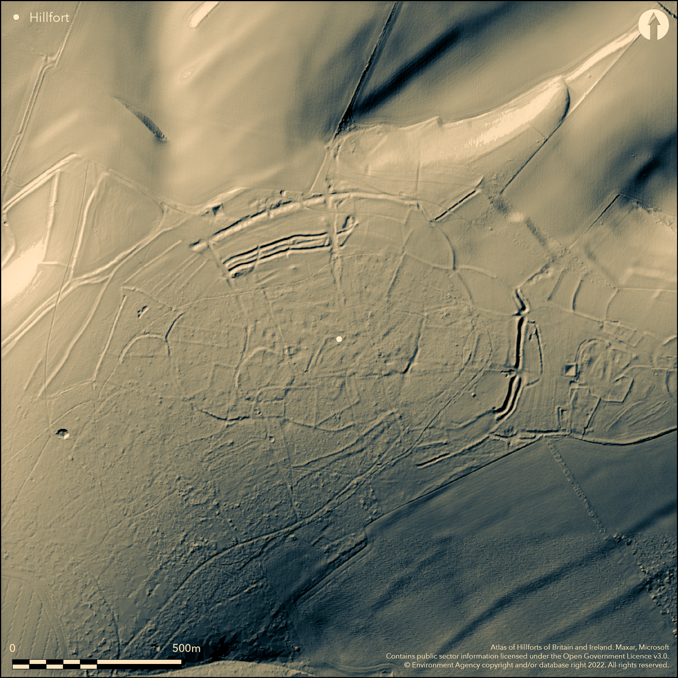
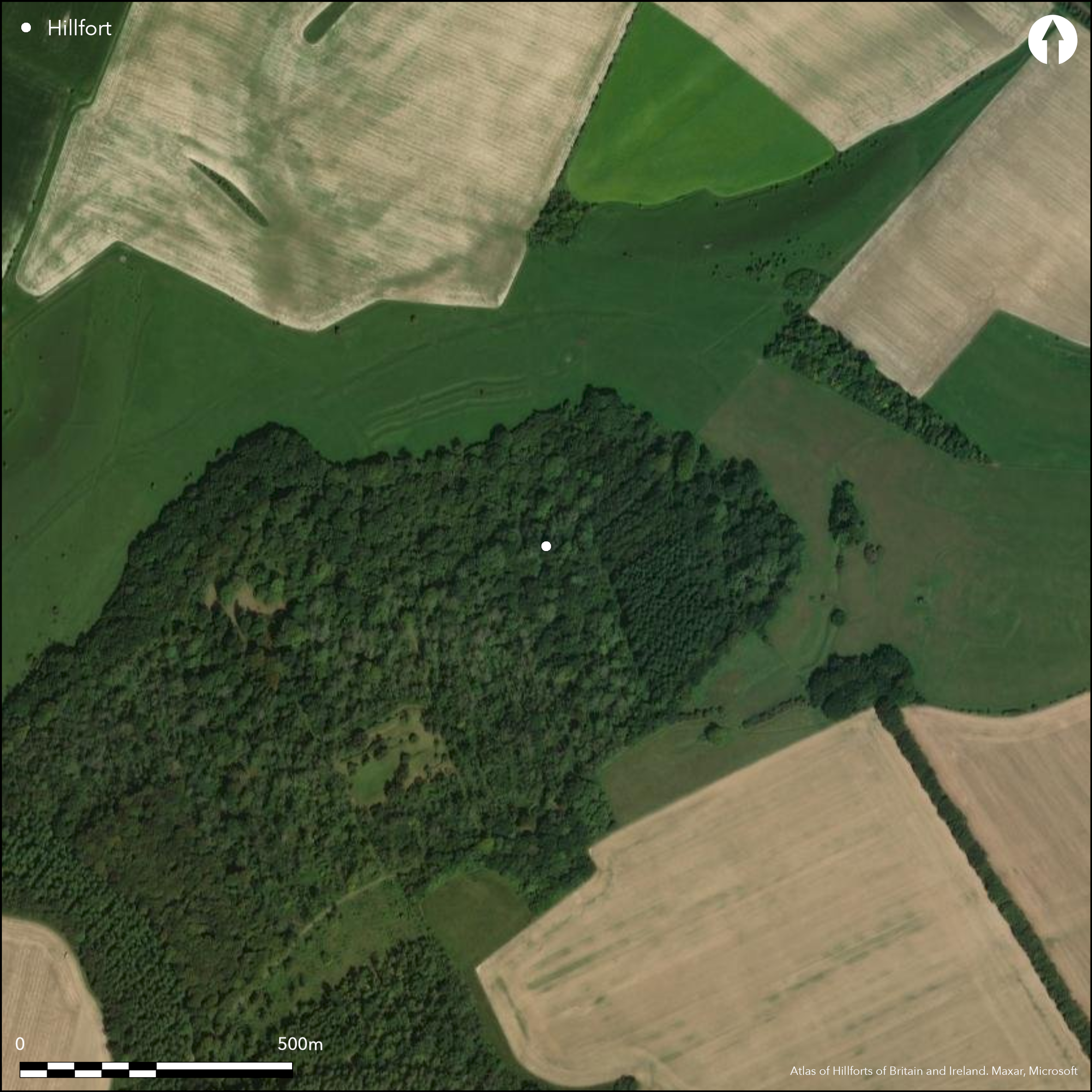
Remains of possible large hillslope fort amid complex of enclosed settlement and field system and Romano-British enclosed settlement, occupy hilltop on NE spur of downland opposite Grovely Castle hillfort (Atlas No 0392). Partial oval hillfort measures 700m by 400m, with enclosed area c. 28ha estimated. In interior field system complex with two associated oval enclosures and one triangular enclosure containing two shallow scoops, probably settlement nucleus. Main bank strengthened by two multiple banks in the N and E, overlying internal field system. Parts of outer ramparts seen as cropmarks to SE of complex. The field system, extending around and beyond hiiltop visible as earthworks immediately around hillfort, but beyond is cropmark only. Parts of system, in particular lynchets on steeper slopes, may be medieval and/or post medieval adaptation. Associated with field system is possible Romano-British settlement outside E end of fort, comprising low banks. Possible house platforms and trackways, of uncertain date, incorporated into field system at NW side of fort. Neolithic perforated mace-head, two Roman coins hoards of AD 337 and AD 408, with part glass vessel, and six silver rings found buried in two earthenware pots in 1906 ramparts on NW brow of hill. The site is very difficult to determine. Interior wooded, part of outer rampart visible as cropmarks. On Ist Ed. OS map (1885-1900).
Citizen Science: ✗
Reliability of Data: Confirmed
Reliability of Interpretation: Unconfirmed
X: -212997 Y: 6642126 (EPSG: 3857)
Longitude: -1.9133881199254354 Latitude: 51.11761866392185 (EPSG:4326)
Country: England; None
Current County or Unitary Authority: Wiltshire
Historic County: Wiltshire
Current Parish/Community/Council/Townland: Barford St Martin; Barford St Martin; Steeple Langford
Part of outer rampart visible as cropmarks.
| Extant | ✓ |
| Cropmark | ✓ |
| Likely Destroyed | ✓ |
Interior wooded.
| Woodland | ✓ |
| Commercial Forestry Plantation | ✗ |
| Parkland | ✗ |
| Pasture (Grazing) | ✓ |
| Arable | ✗ |
| Scrub/Bracken | ✗ |
| Bare Outcrop | ✗ |
| Heather/Moorland | ✗ |
| Heath | ✗ |
| Built-up | ✗ |
| Coastal Grassland | ✗ |
| Other | ✗ |
Remains of possible hillslope fort amid complex of enclosed settlement and field system and Romano-British enclosed settlement, occupy hilltop on NE spur of downland opposite Grovely Castle hillfort.
| Contour Fort | ✗ |
| Partial Contour Fort | ✗ |
| Promontory Fort | ✗ |
| Hillslope Fort | ✓ |
| Level Terrain Fort | ✗ |
| Marsh Fort | ✗ |
| Multiple Enclosure Fort | ✗ |
| Hilltop | ✗ |
| Coastal Promontory | ✗ |
| Inland Promontory | ✗ |
| Valley Bottom | ✗ |
| Knoll/Hillock/Outcrop | ✗ |
| Ridge | ✗ |
| Cliff/Plateau-edge/Scarp | ✗ |
| Hillslope | ✗ |
| Lowland | ✗ |
| Spur | ✓ |
Dominant Topographic Feature: Downland spur
| North | ✓ |
| Northeast | ✗ |
| East | ✗ |
| Southeast | ✗ |
| South | ✗ |
| Southwest | ✗ |
| West | ✗ |
| Northwest | ✗ |
| Level | ✗ |
Altitude: 160.0m
Three parishes on site.
Boundary Type: Parish/Townland
No dating evidence for possible hillfort, Romano-British settlement and finds associated.
Reliability: D - None
| Pre 1200BC | ✗ |
| 1200BC - 800BC | ✗ |
| 800BC - 400BC | ✗ |
| 400BC - AD50 | ✗ |
| AD50 - AD400 | ✗ |
| AD400 - AD 800 | ✗ |
| Post AD800 | ✗ |
| Unknown | ✓ |
| Pre Hillfort: | Neolithic perforated mace-head. |
| Post Hillfort: | Possible. Roman coin evidence. Parts of system, in particular lynchets on steeper slopes, may be medieval and/or post medieval adaptation. |
| Artefactual: | None |
On Ist Ed. OS map (1885-1900). Measured survey RCHME in 1980's. Whole complex extensively recorded on aerial photographs - 2001 EH Stonehenge WHS Mapping Project; 2005-2006 EH Aerial Reconnaisance (south).
| Other (2001): | EH Stonehenge WHS Mapping Project; |
| 1st Identified Map Depiction (None): | OS map. |
| Other (None): | RCHME measured survey. |
| Other (None): | EH Aerial Reconnaisance (south). |
Field system in interior. Possible house platforms and trackways, of uncertain date, incorporated into field system at NW side of fort. Neolithic perforated mace-head, two Roman coins hoards of AD 337 and AD 408, with part glass vessel, and six silver rings were found buried in two earthenware pots, in 1906 by S.W. Doughty while digging for stones on the line of the ramparts on NW brow of hill. Some in British Museum. Extensive aerial reconnaisance surveys by English Heritage.
None
| None | ✓ |
| Spring | ✗ |
| Stream | ✗ |
| Pool | ✗ |
| Flush | ✗ |
| Well | ✗ |
| Other | ✗ |
Field system in interior. Possible house platforms and trackways, of uncertain date, incorporated into field system at NW side of fort.
| No Known Features | ✗ |
| Round Stone Structures | ✗ |
| Rectangular Stone Structures | ✗ |
| Curvilinear Platforms | ✓ |
| Other Roundhouse Evidence | ✗ |
| Pits | ✗ |
| Quarry Hollows | ✗ |
| Other | ✓ |
None
| No Known Excavation | ✓ |
| Pits | ✗ |
| Postholes | ✗ |
| Roundhouses | ✗ |
| Rectangular Structures | ✗ |
| Roads/Tracks | ✗ |
| Quarry Hollows | ✗ |
| Other | ✗ |
| Nothing Found | ✗ |
None
| No Known Geophysics | ✓ |
| Pits | ✗ |
| Roundhouses | ✗ |
| Rectangular Structures | ✗ |
| Roads/Tracks | ✗ |
| Quarry Hollows | ✗ |
| Other | ✗ |
| Nothing Found | ✗ |
Chance finds. Neolithic perforated mace-head, two Roman coins hoards of AD 337 and AD 408, with part glass vessel, and six silver rings were found buried in two earthenware pots, in 1906 by S.W. Doughty while digging for stones on the line of the ramparts on NW brow of hill. Some in British Museum.
| No Known Finds | ✗ |
| Pottery | ✓ |
| Metal | ✓ |
| Metalworking | ✗ |
| Human Bones | ✗ |
| Animal Bones | ✗ |
| Lithics | ✓ |
| Environmental | ✗ |
| Other | ✓ |
Extensive aerial reconnaisance surveys by English Heritage.
| APs Not Checked | ✓ |
| None | ✗ |
| Roundhouses | ✗ |
| Rectangular Structures | ✗ |
| Pits | ✗ |
| Postholes | ✗ |
| Roads/Tracks | ✗ |
| Other | ✗ |
The site is very difficult to explain and no entrances defined.
| 0: | Gaps not determined. |
| 2: | Possible entrances not determined. |
Guard Chambers: ✗
Chevaux de Frise: ✗
Partial oval hillfort measures 700m by 400m. Main bank strengthened by two multiple banks in the N and E, overlying internal field system. Parts of outer ramparts seen as cropmarks to SE of complex, possibly three ditches.
| Area 1: | 28.0ha. |
| Total: | 28.0ha. |
Total Footprint Area: Noneha.
None
| ✗ | Area estimated. |
| ✓ | None |
| NE Quadrant: | 3 |
| SE Quadrant: | 3 |
| SW Quadrant: | 1 |
| NW Quadrant: | 1 |
| Total: | 3 |
| Partial Univallate | ✓ |
| Univallate | ✗ |
| Partial Bivallate | ✗ |
| Bivallate | ✗ |
| Partial Multivallate | ✓ |
| Multivallate | ✗ |
| Unknown | ✗ |
| Partial Univallate | ✗ |
| Univallate | ✗ |
| Partial Bivallate | ✗ |
| Bivallate | ✗ |
| Partial Multivallate | ✗ |
| Multivallate | ✗ |
None
| None | ✗ |
| Earthen Bank | ✓ |
| Stone Wall | ✗ |
| Rubble | ✗ |
| Wall-walk | ✗ |
| Evidence of Timber | ✗ |
| Vitrification | ✗ |
| Other Burning | ✗ |
| Palisade | ✗ |
| Counter Scarp Bank | ✗ |
| Berm | ✗ |
| Unfinished | ✗ |
| Other | ✗ |
None
| None | ✗ |
| Earthen Bank | ✗ |
| Stone Wall | ✗ |
| Murus Duplex | ✗ |
| Timber-framed | ✗ |
| Timber-laced | ✗ |
| Vitrification | ✗ |
| Other Burning | ✗ |
| Palisade | ✗ |
| Counter Scarp Bank | ✗ |
| Berm | ✗ |
| Unfinished | ✗ |
| No Known Excavation | ✓ |
| Other | ✗ |
| ✗ | None |
| ✓ | Possible three ditches. |
Number of Ditches: 3
| ✗ | None |
Pugh, R.B. and Crittall, E. 1957. A history of Wiltshire, 1.1, The Victoria history of the counties of England, 36, 74, 262, 266.
Atlas of Hillforts:
Wikidata:
This work is licensed under CC BY-SA 4.0![]()
![]()
![]() and should be cited as:
and should be cited as:
Lock, Gary and Ralston, Ian. 2024. Atlas of Hillforts of Britain and Ireland. Available at: https://hillforts.arch.ox.ac.uk
Document Version 1.1