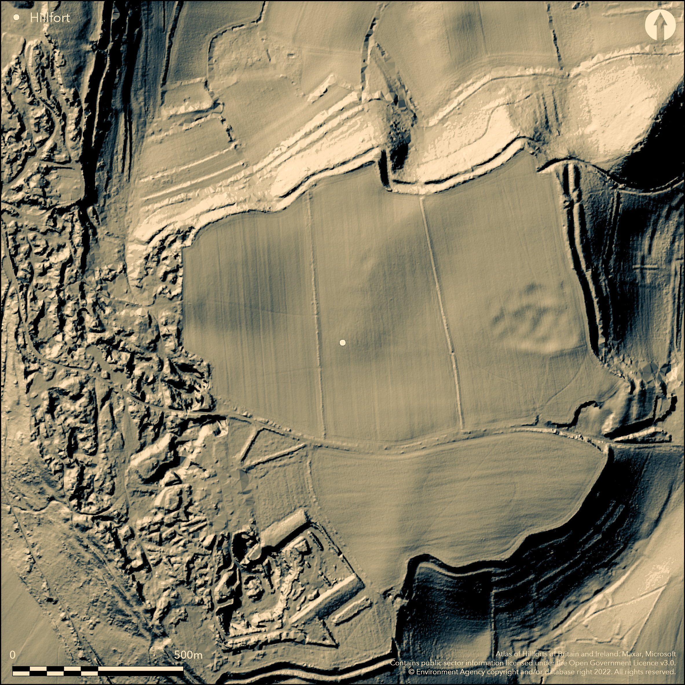
LiDAR 1m DTM Hillshade
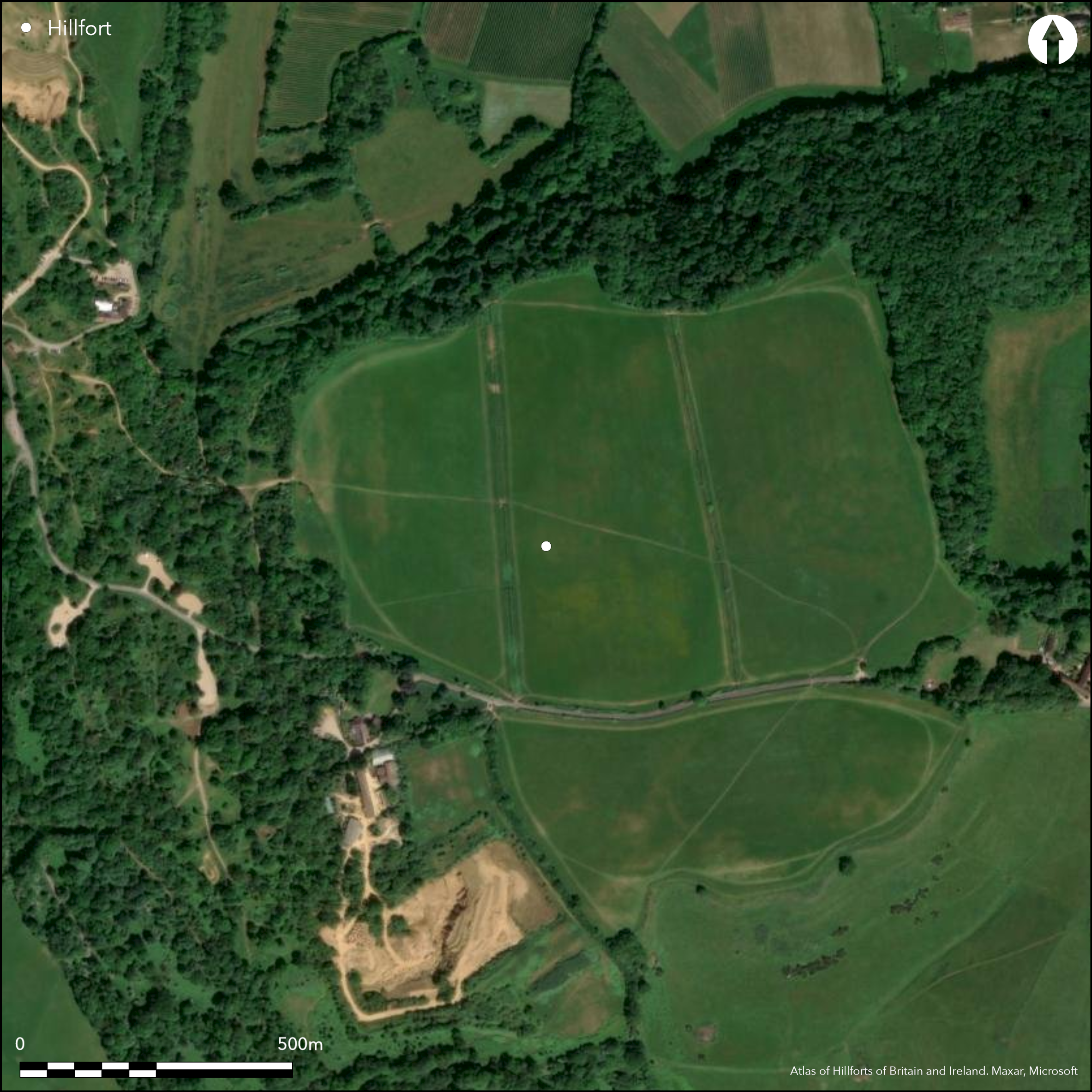
Satellite Imagery
LiDAR 1m DTM Hillshade
Satellite Imagery
Scroll left/right to view further images.
HER: Somerset 55103 (None)
NMR: ST 41 NE 12 (193165)
SM: 1003678
NGR: ST484165
X: 348409 Y: 116570 (OSGB36)
Very large L-shaped multivallate contour hillfort located on shelly limestone plateau of Hamdon Hill with spur projecting from its NW corner. At 84ha one of the largest hillforts in the country. On 1st Ed OS map (1885-1900). Sides of both plateau and spur steep and ramparts closely follow contours although affected by quarrying. Site roughly oblong plateau c. 800m N-S and 950m E-W with spur running N from NW corner, measuring c. 550m N-S and 360m wide at N and 180m wide where joins main hill. Possible that NW spur may have been focus for primary hillfort, with main plateau containing unenclosed settlement. Ramparts fairly uniform mostly two ramparts, to c. 2m high, with outer ditches, generally c. 2.5m-3.5m wide. Inner rampart face steep, best on N, and E, but where slope steepens ditch becomes terrace. Second bank has silted ditch, but where ditch again becomes terrace, bank becomes steep scarp. On more level SW and at extreme N corner of spur triple banks. Multiple entrances around perimeter, mostly modern, but three possibly original. Gap through E rampart on NW spur probably cut by Roman army, but other two probably earlier. First at head of coombe separating spur from plateau on NW, now totally destroyed by quarrying, second on SE near Batemoor Barn, both gates inturned. Site extensively quarried on W, continuing and extending. A a result many watching briefs with geophysical surveys and minor excavations. Three excavations of note: first by H.St.G. Gray 1923-30; second by G. Smith 1983 and three year excavation in advance of quarrying by Cambridge Archaeological Unit and Cardiff University beginning in 2011. Very many finds and chance finds from quarrying, which, with excavation detail and survey, have shed much light on the site's intensive occupancy and interior features to the NW and SW. Large areas not in NW and SW appear devoid of features, but much investigation remains. Evidence of Neolithic to Roman activity on the site, a Roman villa now recognised from aerial photographs. Mostly pasture with some scrub clearance.
Citizen Science: ✗
Reliability of Data: Confirmed
Reliability of Interpretation: Confirmed
X: -304545 Y: 6611780 (EPSG: 3857)
Longitude: -2.7357738310675206 Latitude: 50.94618657382244 (EPSG:4326)
Country: England; None
Current County or Unitary Authority: Somerset
Historic County: Somerset
Current Parish/Community/Council/Townland: Montacute; Norton Sub Hamdon; Stoke Sub Hamdon
Much affected by quarrying for valuable Ham Hill stone on W side; continuing and extending. Some regular ploughing in E of interior. Banks impressive in places.
| Extant | ✓ |
| Cropmark | ✗ |
| Likely Destroyed | ✓ |
Mostly pasture with some scrub clearance. Quarry.
| Woodland | ✗ |
| Commercial Forestry Plantation | ✗ |
| Parkland | ✗ |
| Pasture (Grazing) | ✓ |
| Arable | ✗ |
| Scrub/Bracken | ✓ |
| Bare Outcrop | ✗ |
| Heather/Moorland | ✗ |
| Heath | ✗ |
| Built-up | ✗ |
| Coastal Grassland | ✗ |
| Other | ✓ |
Very large L-shaped multivallate contour hillfort located on shelly limestone plateau of Hamdon Hill with spur projecting from its NW corner.
| Contour Fort | ✓ |
| Partial Contour Fort | ✗ |
| Promontory Fort | ✗ |
| Hillslope Fort | ✗ |
| Level Terrain Fort | ✗ |
| Marsh Fort | ✗ |
| Multiple Enclosure Fort | ✗ |
| Hilltop | ✓ |
| Coastal Promontory | ✗ |
| Inland Promontory | ✗ |
| Valley Bottom | ✗ |
| Knoll/Hillock/Outcrop | ✗ |
| Ridge | ✗ |
| Cliff/Plateau-edge/Scarp | ✗ |
| Hillslope | ✗ |
| Lowland | ✗ |
| Spur | ✗ |
Dominant Topographic Feature: Extensive limestone plateau.
| North | ✗ |
| Northeast | ✗ |
| East | ✗ |
| Southeast | ✗ |
| South | ✗ |
| Southwest | ✗ |
| West | ✗ |
| Northwest | ✗ |
| Level | ✓ |
Altitude: 89.6m
Site covered by three parishes.
Boundary Type: Parish/Townland
Most intensive occupancy between 1st century BC and up to 60-70 AD, but possible earlier origins. Roman villa at SE. Numerous dateable finds including late - probably Belgic - pit burial, pottery Halstatt form, Glastonbury type bowls, bead-rim vessels and other south-western type of Claudian conquest; bronze bulls-head of Celtic type (possibly ornamental chariot fitting); chariot horn caps; iron tyres of wheels; bridle-bits and nosebands. Iron currency bars, silvered bronze coins of Durotriges. Excavations 1930 revealed closely grouped area of dwelling and storage pits of pre-Roman date.
Reliability: A - High
| Pre 1200BC | ✗ |
| 1200BC - 800BC | ✗ |
| 800BC - 400BC | ✓ |
| 400BC - AD50 | ✓ |
| AD50 - AD400 | ✗ |
| AD400 - AD 800 | ✗ |
| Post AD800 | ✗ |
| Unknown | ✗ |
| Pre Hillfort: | None |
| Post Hillfort: | None |
| Artefactual: | Numerous dateable finds from Mesolithic to Roman periods. |
| C14: | None |
On 1st Ed OS map (1885-1900). Site extensively quarried on W, continuing and extending. A a result many watching briefs with geophysical surveys and minor excavations. Three excavations of note: first by H.St.G. Gray 1923-30; second by G. Smith 1983 and three year excavation in advance of quarrying by Cambridge Archaeological Unit and Cardiff University beginning in 2011. Very RCHME survey, ref. no. 1005359. 2011 geophysical survey, EH, ADS Grey Lit. Library, OASIS ref: englishh4-125813.
| Other (1980): | Visit by Hillfort Study Group |
| Excavation (1983): | G. Smith |
| Other (2009): | Evaluation Cambridge Archaeological Unit. |
| Geophysical Survey (2011): | English Heritage. |
| 1st Identified Map Depiction (None): | OS map. |
| Excavation (None): | H.St.G Gray. |
| Other (None): | Watching briefs |
| Earthwork Survey (None): | Measured survey RCHME. |
| Geophysical Survey (None): | AML. Bradford. |
| Excavation (None): | Minor excavations. |
| Excavation (None): | Cambridge Archaeological Unit. |
Excavations 1930 revealed closely grouped area of dwelling and storage pits of pre-Roman date. Geophysics over years found, for example, trackways, enclosures, ring ditches, pits and areas of industrial activity. Numerous finds including late - probably Belgic - pit burial, pottery Halstatt form, Glastonbury type bowls, bead-rim vessels and other south-western type of Claudian conquest; bronze bulls-head of Celtic type (possibly ornamental chariot fitting); chariot horn caps; iron tyres of wheels; bridle-bits and nosebands. Iron currency bars, silvered bronze coins of Durotriges. Excavations 1930 revealed closely grouped area of dwelling and storage pits of pre-Roman date. Further occupation of Hamdon Hill during Roman period, including a villa in E interior at ST 41 NE 8. Miscellaneous finds of Saxon iron shield boss, and 14th century jug spout and bronze spur. Roman villa now being recognised from aerial photographs.
No details, but possible source within.
| None | ✗ |
| Spring | ✗ |
| Stream | ✗ |
| Pool | ✗ |
| Flush | ✗ |
| Well | ✗ |
| Other | ✓ |
Much quarrying may have masked any evidence.
| No Known Features | ✓ |
| Round Stone Structures | ✗ |
| Rectangular Stone Structures | ✗ |
| Curvilinear Platforms | ✗ |
| Other Roundhouse Evidence | ✗ |
| Pits | ✗ |
| Quarry Hollows | ✗ |
| Other | ✗ |
Excavations 1930 revealed closely grouped area of dwelling and storage pits of pre-Roman date.
| No Known Excavation | ✗ |
| Pits | ✓ |
| Postholes | ✓ |
| Roundhouses | ✓ |
| Rectangular Structures | ✗ |
| Roads/Tracks | ✗ |
| Quarry Hollows | ✗ |
| Other | ✓ |
| Nothing Found | ✗ |
Trackways, enclosures, ring ditches, pits and areas of industrial activity.
| No Known Geophysics | ✗ |
| Pits | ✓ |
| Roundhouses | ✓ |
| Rectangular Structures | ✗ |
| Roads/Tracks | ✓ |
| Quarry Hollows | ✗ |
| Other | ✗ |
| Nothing Found | ✗ |
Numerous finds including late - probably Belgic - pit burial, pottery Halstatt form, Glastonbury type bowls, bead-rim vessels and other south-western type of Claudian conquest; bronze bulls-head of Celtic type (possibly ornamental chariot fitting); chariot horn caps; iron tyres of wheels; bridle-bits and nosebands. Iron currency bars, silvered bronze coins of Durotriges. Excavations 1930 revealed closely grouped area of dwelling and storage pits of pre-Roman date. Further occupation of Hamdon Hill during Roman period, including a villa in E interior at ST 41 NE 8. Miscellaneous finds of Saxon iron shield boss, and 14th century jug spout and bronze spur.
| No Known Finds | ✗ |
| Pottery | ✓ |
| Metal | ✓ |
| Metalworking | ✓ |
| Human Bones | ✓ |
| Animal Bones | ✓ |
| Lithics | ✓ |
| Environmental | ✓ |
| Other | ✓ |
Roman villa now being recognised from aerial photographs.
| APs Not Checked | ✗ |
| None | ✗ |
| Roundhouses | ✗ |
| Rectangular Structures | ✗ |
| Pits | ✗ |
| Postholes | ✗ |
| Roads/Tracks | ✗ |
| Other | ✓ |
Most of the entrances around the perimeter are not original but three are of note. The gap through the E defences on the NW spur was probably cut by the Roman army, but two were probably earlier. That at the head of a coombe separating the spur from the plateau on the NW, now been totally destroyed by quarrying, and that to the SE near Batemoor Barn, both inturned.
| 3: | Numerous modern gaps, but three earlier of note. |
| 2: | NW gap probably Roman, two earlier. |
Guard Chambers: ✗
Chevaux de Frise: ✗
| 1. Simple Gap (North west): | Probably cut by Roman army. |
| 2. In-turned (North west): | Destroyed by quarrying. |
| 3. In-turned (South east): | None |
Defences are fairly uniform and mostly involve two ramparts, each with outer ditches, but on more level SW and at the extreme N spur triple banks can be seen. The inner rampart face is steep, but the bank lacks significance except on the N and E sides where it is prominent. At the foot of this bank a ditch becomes a terrace or ledge where the slope steepens. Beyond is the second bank and another ditch, and where the ditch again becomes a terrace, the bank degenerates into a steep scarp. To the SW and at the NW/NE corner of spur beyond second rampart ditch is another bank or scarp.
| Area 1: | 84.0ha. |
| Total: | 84.0ha. |
Total Footprint Area: Noneha.
None
| ✓ | Possible that NW spur may have been focus for primary hillfort, with main plateau containing unenclosed settlement. No definite details. |
| ✓ | None |
| NE Quadrant: | 3 |
| SE Quadrant: | 2 |
| SW Quadrant: | 3 |
| NW Quadrant: | 3 |
| Total: | 3 |
| Partial Univallate | ✗ |
| Univallate | ✗ |
| Partial Bivallate | ✓ |
| Bivallate | ✗ |
| Partial Multivallate | ✓ |
| Multivallate | ✗ |
| Unknown | ✗ |
| Partial Univallate | ✗ |
| Univallate | ✗ |
| Partial Bivallate | ✗ |
| Bivallate | ✗ |
| Partial Multivallate | ✗ |
| Multivallate | ✗ |
None
| None | ✗ |
| Earthen Bank | ✓ |
| Stone Wall | ✗ |
| Rubble | ✗ |
| Wall-walk | ✗ |
| Evidence of Timber | ✗ |
| Vitrification | ✗ |
| Other Burning | ✗ |
| Palisade | ✗ |
| Counter Scarp Bank | ✗ |
| Berm | ✗ |
| Unfinished | ✗ |
| Other | ✗ |
None
| None | ✗ |
| Earthen Bank | ✓ |
| Stone Wall | ✓ |
| Murus Duplex | ✗ |
| Timber-framed | ✗ |
| Timber-laced | ✗ |
| Vitrification | ✗ |
| Other Burning | ✗ |
| Palisade | ✗ |
| Counter Scarp Bank | ✗ |
| Berm | ✗ |
| Unfinished | ✗ |
| No Known Excavation | ✗ |
| Other | ✗ |
| ✗ | None |
| ✓ | External ditches to two inner ramparts. Silted and terrace in places. |
Number of Ditches: 2
| ✗ | None |
Anon. 2013. Bones to unpick. Ham Hill, Somerset. Current Archaeol, 2013, 40-1.
Brown, I. 2009. Beacons in the landscape. The hillforts of England and Wales, Oxford: Windgather Press/Oxbow Books.
Burrow, E.J. 1924. Ancient earthworks and camps of Somerset, Cheltenham: E.J. Burrow, 94-95.
Cambridge Archaeological Unit - see https://www.cam.ac.uk/research/news/final-excavations-underway-at-ham-hill (accessed March 2016).
Gray, H. St George. 1926. Excavations at Ham Hill, South Somerset, Part III, Proc Somerset Archaeol Natur Hist Soc, 82, 83-107.
Sharples, N., Evans, C., Slater, A., Payne, A. and Linford, N. 2012. Ham and mustard. Brit Archaeol, 123, 34-9.
Smith, G. 1990. Excavations at Ham Hill, 1983, Proc Somerset Archaeol Natur Hist Soc, 134, 27-47.
Atlas of Hillforts:
Wikidata:
This work is licensed under CC BY-SA 4.0

 and should be cited as:
Lock, Gary and Ralston, Ian. 2024. Atlas of Hillforts of Britain and Ireland. Available at: https://hillforts.arch.ox.ac.uk
Document Version 1.1