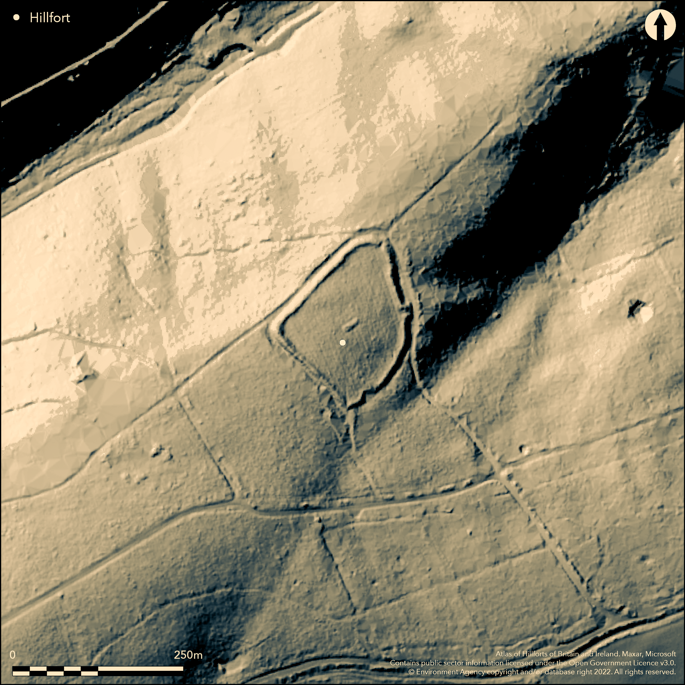
LiDAR 1m DTM Hillshade
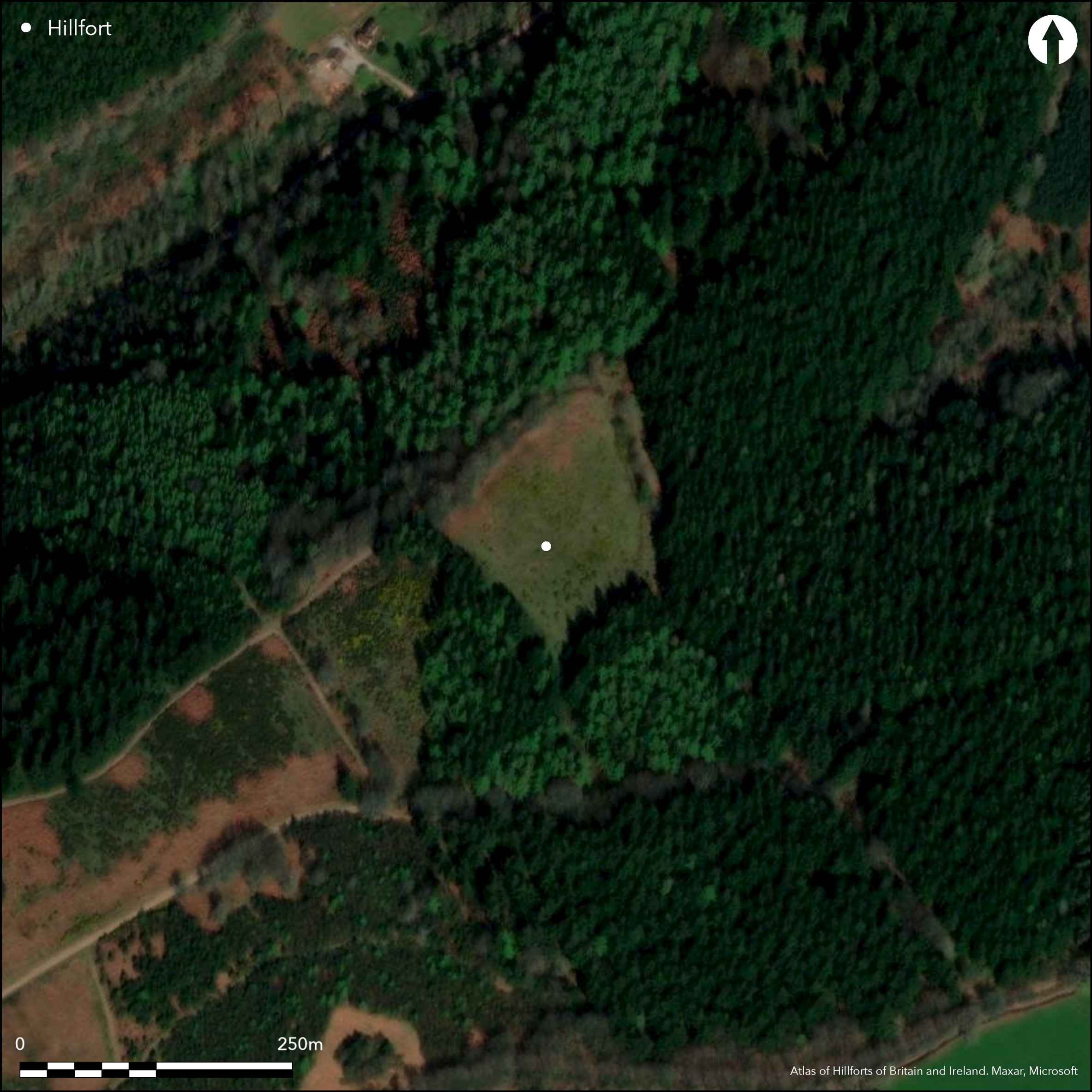
Satellite Imagery
LiDAR 1m DTM Hillshade
Satellite Imagery
Scroll left/right to view further images.
HER: Somerset 11128 (None)
NMR: ST 13 NE 17 (389501)
SM: 1007669
NGR: ST18433621
X: 318430 Y: 136210 (OSGB36)
Hillslope enclosure located on the lower slopes of a gently sloping NE-facing spur of E edge of Quantock Hills in Forestry Commission Park Plantation, part of Quantock Forest. On 1st Ed. OS map (1885-1900). Often called Cockercombe Camp. Sub-rectangular in shape. c. 180m by 150m, with rampart and silted up external ditch (now intermittent) giving a maximum width for both of 14m and rampart width of 7m-10m, 3m high on the downslope side. Simple rampart constructed of earth and stone, and ditch all but gone on NE and for most of NW sides. Rampart best preserved to W where up to 1.5m high interior and ditch 1m deep, less so on NW and SE where reaches 0.4m, making use also of the natural slope. In places interior quarry scoops. Simple entrance downslope on E possibly original and c. 3.6m across, with causeway over ditch and slightly out-turned banks, gives a narrow entrance up into the fort. Second narrow gap to N corner and some discussion as to whether this is original. Two other gaps to the NE later. To NE and NW forestry tracks damaged the ditch, a surviving stretch to the N of entrance has small counterscarp to 0.7m high. Interior uneven, the result of past conifer plantation and possible medieval or post-medieval pillow mound. WWII activity, including slit trenches and small pits. Now free of trees but surrounded by conifer plantations. No interventions.
Citizen Science: ✓
Reliability of Data: Confirmed
Reliability of Interpretation: Confirmed
X: -352534 Y: 6642422 (EPSG: 3857)
Longitude: -3.166864752864107 Latitude: 51.119292674163844 (EPSG:4326)
Country: England
Current County or Unitary Authority: Somerset
Historic County: Somerset
Current Parish/Community/Council/Townland: Over Stowey
Interior uneven as result of past conifer plantation.
| Extant | ✓ |
| Cropmark | ✗ |
| Likely Destroyed | ✗ |
Site cleared of conifer plantation, which surrounds the fort. WWII activity, including slit trenches and small pits.
| Woodland | ✗ |
| Commercial Forestry Plantation | ✗ |
| Parkland | ✗ |
| Pasture (Grazing) | ✗ |
| Arable | ✗ |
| Scrub/Bracken | ✓ |
| Bare Outcrop | ✗ |
| Heather/Moorland | ✗ |
| Heath | ✗ |
| Built-up | ✗ |
| Coastal Grassland | ✗ |
| Other | ✓ |
Hillslope enclosure located on the lower slopes of a gently sloping NE-facing spur of E edge of Quantock Hills in Forestry Commission Park Plantation, part of Quantock Forest.
| Contour Fort | ✗ |
| Partial Contour Fort | ✗ |
| Promontory Fort | ✗ |
| Hillslope Fort | ✓ |
| Level Terrain Fort | ✗ |
| Marsh Fort | ✗ |
| Multiple Enclosure Fort | ✗ |
| Hilltop | ✗ |
| Coastal Promontory | ✗ |
| Inland Promontory | ✗ |
| Valley Bottom | ✗ |
| Knoll/Hillock/Outcrop | ✗ |
| Ridge | ✗ |
| Cliff/Plateau-edge/Scarp | ✗ |
| Hillslope | ✓ |
| Lowland | ✗ |
| Spur | ✗ |
Dominant Topographic Feature: E-facing spur of Quantock Hills.
| North | ✗ |
| Northeast | ✓ |
| East | ✗ |
| Southeast | ✗ |
| South | ✗ |
| Southwest | ✗ |
| West | ✗ |
| Northwest | ✗ |
| Level | ✗ |
Altitude: 235.0m
N/A
None
Reliability: D - None
| Pre 1200BC | ✗ |
| 1200BC - 800BC | ✗ |
| 800BC - 400BC | ✗ |
| 400BC - AD50 | ✗ |
| AD50 - AD400 | ✗ |
| AD400 - AD 800 | ✗ |
| Post AD800 | ✗ |
| Unknown | ✓ |
| Pre Hillfort: | None |
| Post Hillfort: | Possible medieval or post-medieval pillow mound. WWII activity, including slit trenches and small pits. |
On 1st Ed. OS map (1885-1900). 1982 watching brief at S corner. Measured survey - English Heritage survey of Quantock Hills AONB. Aerial photograph interpretation - English Heritage Quantock Hills NMP.
| Other (1982): | Watching brief. |
| 1st Identified Map Depiction (None): | 1st ED OS |
| Other (None): | English Heritage measured survey of Quantock Hills AONB. |
| Other (None): | Aerial photograph interpretation - English Heritage Quantock Hills NMP. |
Pillow mound and WWII slit trenches and pits. Aerial photograph interpretation - English Heritage Quantock Hills NMP - not determined.
None
| None | ✓ |
| Spring | ✗ |
| Stream | ✗ |
| Pool | ✗ |
| Flush | ✗ |
| Well | ✗ |
| Other | ✗ |
Quarry hollows, pillow mound and WWII slit trenches and small pits.
| No Known Features | ✗ |
| Round Stone Structures | ✗ |
| Rectangular Stone Structures | ✗ |
| Curvilinear Platforms | ✗ |
| Other Roundhouse Evidence | ✗ |
| Pits | ✗ |
| Quarry Hollows | ✓ |
| Other | ✓ |
None
| No Known Excavation | ✓ |
| Pits | ✗ |
| Postholes | ✗ |
| Roundhouses | ✗ |
| Rectangular Structures | ✗ |
| Roads/Tracks | ✗ |
| Quarry Hollows | ✗ |
| Other | ✗ |
| Nothing Found | ✗ |
None
| No Known Geophysics | ✓ |
| Pits | ✗ |
| Roundhouses | ✗ |
| Rectangular Structures | ✗ |
| Roads/Tracks | ✗ |
| Quarry Hollows | ✗ |
| Other | ✗ |
| Nothing Found | ✗ |
No finds from watching brief.
| No Known Finds | ✓ |
| Pottery | ✗ |
| Metal | ✗ |
| Metalworking | ✗ |
| Human Bones | ✗ |
| Animal Bones | ✗ |
| Lithics | ✗ |
| Environmental | ✗ |
| Other | ✗ |
Aerial photograph interpretation - English Heritage Quantock Hills NMP - not determined.
| APs Not Checked | ✓ |
| None | ✗ |
| Roundhouses | ✗ |
| Rectangular Structures | ✗ |
| Pits | ✗ |
| Postholes | ✗ |
| Roads/Tracks | ✗ |
| Other | ✗ |
Simple entrance downslope on E possibly original and c. 3.6m across, with causeway over the ditch and slightly out-turned banks, gives a narrow entrance up into fort. Second narrow gap to the N corner and some discussion as to whether this is original. Two other gaps to the NE later.
| 4: | Two breaks to NE modern. |
| 2: | There is discussion as to whether either, or both, of entrances are original. |
Guard Chambers: ✗
Chevaux de Frise: ✗
| 1. Out-turned (East): | Slightly out-turned. Causewayed |
| 2. Simple Gap (North): | None |
Rampart and silted up external ditch (now intermittent) giving a maximum width for both of 14m and rampart width of 7m-10m, 3m high on the downslope side. Simple rampart constructed of earth and stone, and ditch all but gone on NE and for most of NW sides. The rampart is best preserved to the W where up to 1.5m high interior and ditch 1m deep, less so on NW and SE where reaches 0.4m, making use also of the natural slope. To NE and NW forestry tracks have damaged the ditch, a surviving stretch to the N of entrance has small counterscarp to 0.7m high. 1983 watching brief exposed part of ditch 1m deep.
| Area 1: | 1.2ha. |
| Total: | 1.2ha. |
Total Footprint Area: Noneha.
None
| ✗ | None |
| ✓ | None |
| NE Quadrant: | 1 |
| SE Quadrant: | 1 |
| SW Quadrant: | 1 |
| NW Quadrant: | 1 |
| Total: | 1 |
| Partial Univallate | ✗ |
| Univallate | ✓ |
| Partial Bivallate | ✗ |
| Bivallate | ✗ |
| Partial Multivallate | ✗ |
| Multivallate | ✗ |
| Unknown | ✗ |
| Partial Univallate | ✗ |
| Univallate | ✗ |
| Partial Bivallate | ✗ |
| Bivallate | ✗ |
| Partial Multivallate | ✗ |
| Multivallate | ✗ |
Banks of earth and stone. Surviving stretch of ditch to N of entrance has small counterscarp to 0.7m high.
| None | ✗ |
| Earthen Bank | ✓ |
| Stone Wall | ✓ |
| Rubble | ✗ |
| Wall-walk | ✗ |
| Evidence of Timber | ✗ |
| Vitrification | ✗ |
| Other Burning | ✗ |
| Palisade | ✗ |
| Counter Scarp Bank | ✓ |
| Berm | ✗ |
| Unfinished | ✗ |
| Other | ✗ |
Watching brief exposed outer side and base of ditch; c. 1m deep with flat base and 70 degree sloping side. Fill friable clay with stones above angular block of stone.
| None | ✓ |
| Earthen Bank | ✗ |
| Stone Wall | ✗ |
| Murus Duplex | ✗ |
| Timber-framed | ✗ |
| Timber-laced | ✗ |
| Vitrification | ✗ |
| Other Burning | ✗ |
| Palisade | ✗ |
| Counter Scarp Bank | ✗ |
| Berm | ✗ |
| Unfinished | ✗ |
| No Known Excavation | ✗ |
| Other | ✗ |
| ✗ | None |
| ✓ | Intermittent ditch silted up and all but gone to NE and NW. Watching brief exposed part of ditch 1m deep. |
Number of Ditches: 1
| ✗ | None |
Burrow, I. 1981. Hillfort and hill-top settlement in Somerset in the first to eighth centuries AD, BAR British Series 1(1974) - 91, 243-44.
Burrow, I. 1983. Over Stowey, Cockercombe Castle ST18423614, in eds I. Burrow, S. Minnitt and B. Murless, Somerset Archaeology 1982, Proc Somerset Archaeolog Natur Hist Soc, 127, 16.
Atlas of Hillforts:
Wikidata:
This work is licensed under CC BY-SA 4.0

 and should be cited as:
Lock, Gary and Ralston, Ian. 2024. Atlas of Hillforts of Britain and Ireland. Available at: https://hillforts.arch.ox.ac.uk
Document Version 1.1