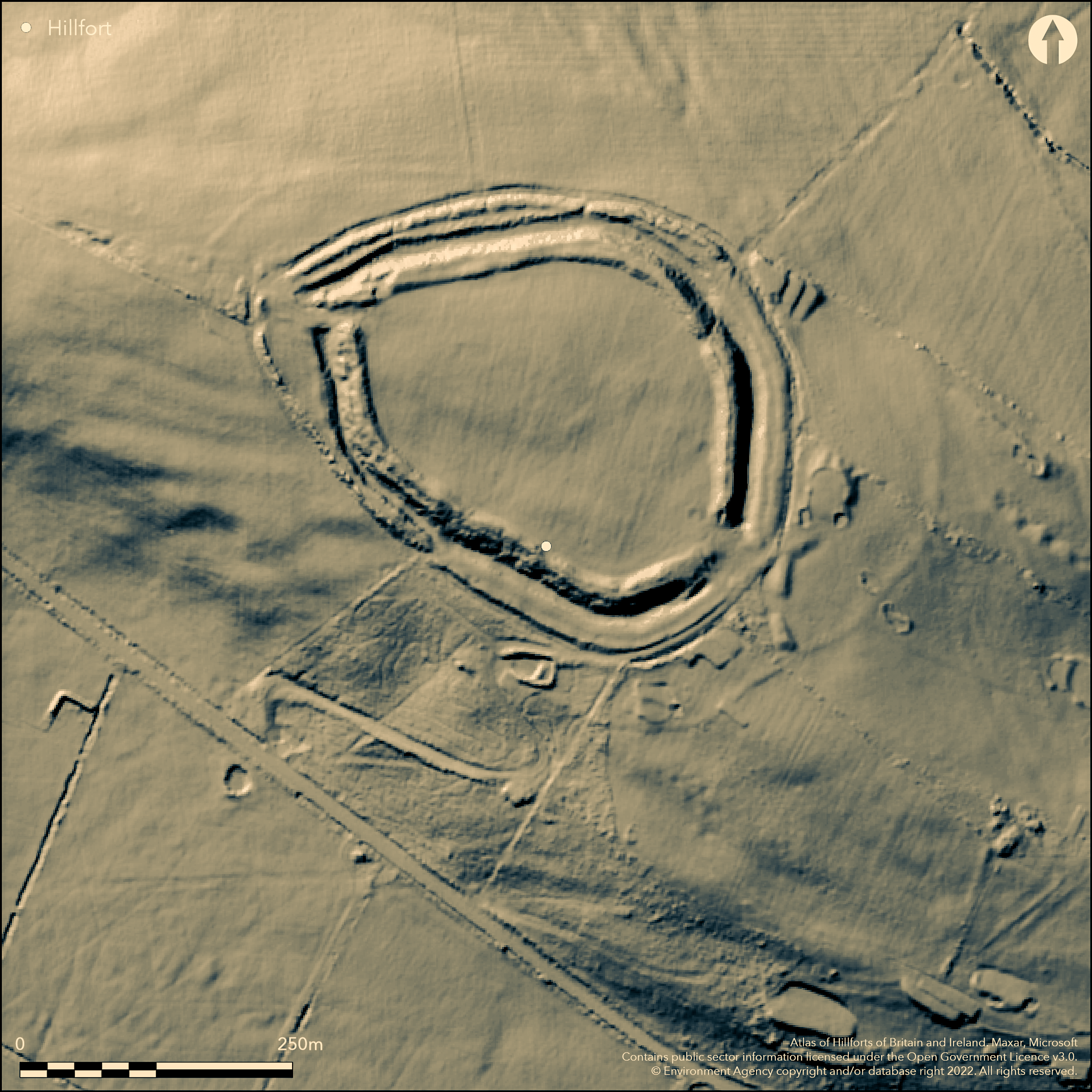
LiDAR 1m DTM Hillshade
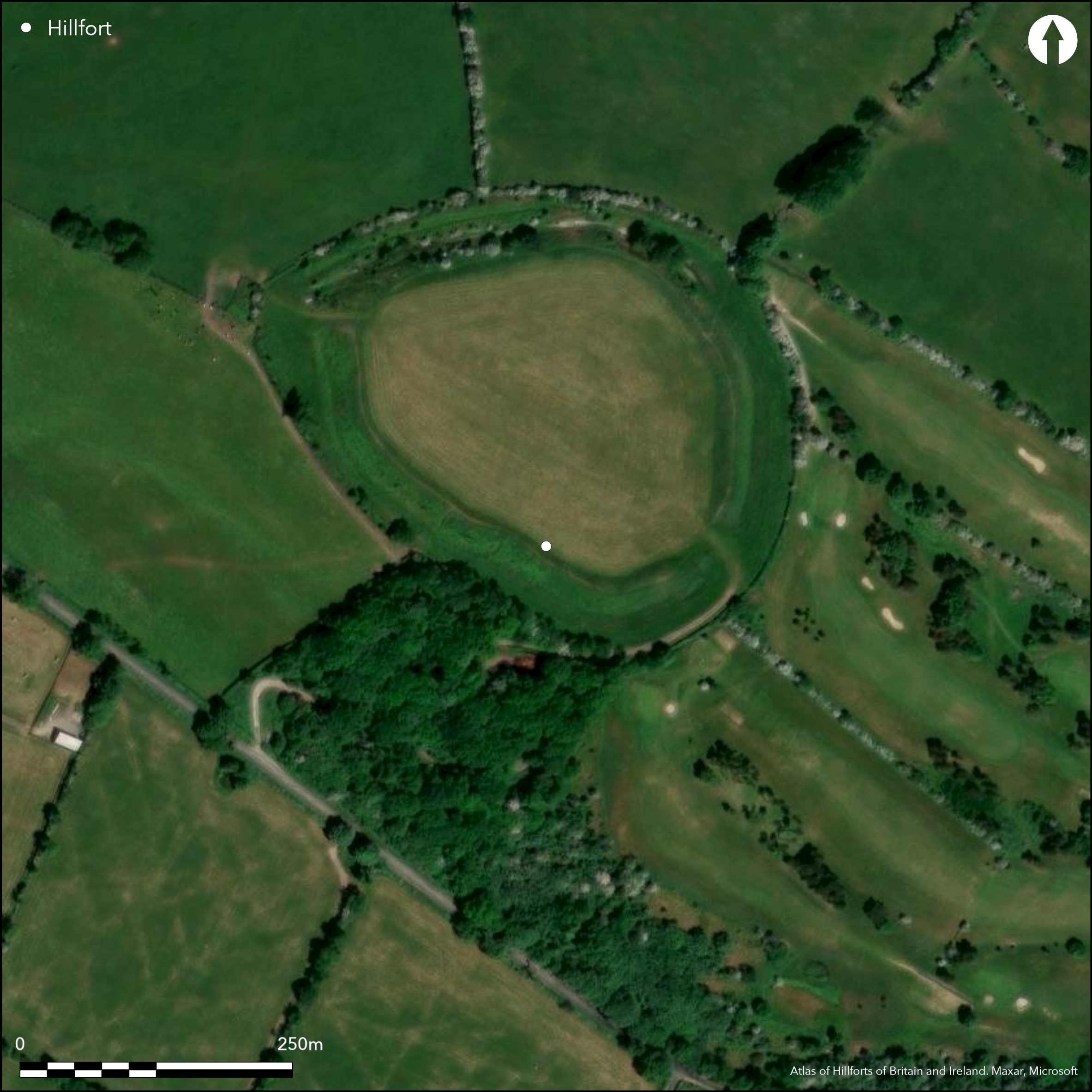
Satellite Imagery
LiDAR 1m DTM Hillshade
Satellite Imagery
Scroll left/right to view further images.
HER: Somerset 23349 (None)
NMR: ST 64 NW 16 (200279)
SM: 1015494
NGR: ST610471
X: 361000 Y: 147100 (OSGB36)
Bivallate oval contour hillfort located on summit of round hilltop on S side of Mendip Hills. Extensive views to N, S, W. Slopes steep on SW side, moderate elsewhere. On 1st Ed OS map (1885-1900). Two intermittent ramparts complete circuit. Possible traces of stone core to bank at SE entrance. The inner to 1.5m-3m high with external ditch of 2m-2.5m deep and counterscarp 0.3m-1.2m high mainly visible on N and SW sides. On SW main bank and ditch separated by berm. Inner ditch to N often filled with water. Outer rampart is smaller in scale, with bank 0.3m-1.2m high with external ditch 0.2m-2m deep with counterscarp, most notable on NW but traceable elsewhere. On SW only a break of slope visible with terrace where ditch ploughed out. To N counterscarp of inner circuit and main bank of outer rampart seen as twin banks with either side of a space between. Traces of possible outwork bank, now seen as ploughed down bank to 1m high, and shallow ditch cover SE entrance. Much plough damage to ramparts and ditch, levelled in places and both entrances damaged, but incomplete sections could indicate hillfort unfinished. Minimal investigations, undated.
Citizen Science: ✓
Reliability of Data: Confirmed
Reliability of Interpretation: Confirmed
X: -284962 Y: 6660604 (EPSG: 3857)
Longitude: -2.559859479856871 Latitude: 51.22169978095364 (EPSG:4326)
Country: England; None
Current County or Unitary Authority: Somerset
Historic County: Somerset
Current Parish/Community/Council/Townland: Croscombe; St Cuthbert Out
Much plough damage to rampart and ditch, levelled in places. Outer ditch used as field boundary with hedge or hedge bank around entire circuit. Outside, the remaining width of ditch and counterscarp degraded by past ploughing. Outwork disturbed by creation of golf course on E side and now seen as low linear bank for c. 22m, 0.4m high and 11m wide. Both entrances damaged.
| Extant | ✓ |
| Cropmark | ✗ |
| Likely Destroyed | ✓ |
Banks grassed, interior cultivated.
| Woodland | ✗ |
| Commercial Forestry Plantation | ✗ |
| Parkland | ✗ |
| Pasture (Grazing) | ✓ |
| Arable | ✓ |
| Scrub/Bracken | ✓ |
| Bare Outcrop | ✗ |
| Heather/Moorland | ✗ |
| Heath | ✗ |
| Built-up | ✗ |
| Coastal Grassland | ✗ |
| Other | ✗ |
Bivallate contour hillfort located on summit of round hilltop on S side of Mendip Hills. Extensive views to N, S, W.
| Contour Fort | ✓ |
| Partial Contour Fort | ✗ |
| Promontory Fort | ✗ |
| Hillslope Fort | ✗ |
| Level Terrain Fort | ✗ |
| Marsh Fort | ✗ |
| Multiple Enclosure Fort | ✗ |
| Hilltop | ✓ |
| Coastal Promontory | ✗ |
| Inland Promontory | ✗ |
| Valley Bottom | ✗ |
| Knoll/Hillock/Outcrop | ✗ |
| Ridge | ✗ |
| Cliff/Plateau-edge/Scarp | ✗ |
| Hillslope | ✗ |
| Lowland | ✗ |
| Spur | ✗ |
Dominant Topographic Feature: Rounded hilltop.
| North | ✗ |
| Northeast | ✗ |
| East | ✗ |
| Southeast | ✗ |
| South | ✗ |
| Southwest | ✗ |
| West | ✗ |
| Northwest | ✗ |
| Level | ✓ |
Altitude: 292.0m
Boundary Type: Parish/Townland
None
Reliability: D - None
| Pre 1200BC | ✗ |
| 1200BC - 800BC | ✗ |
| 800BC - 400BC | ✗ |
| 400BC - AD50 | ✗ |
| AD50 - AD400 | ✗ |
| AD400 - AD 800 | ✗ |
| Post AD800 | ✗ |
| Unknown | ✓ |
| Pre Hillfort: | None |
| Post Hillfort: | None |
In Aubrey's Monumenta Britannica (1665-1693). On 1st Ed OS map (1885-1900).
| 1st Identified Written Reference (None): | In Aubrey's Monumenta Britannica. |
| 1st Identified Map Depiction (None): | 1st Ed OS. |
Chance find of double-edged tanged knife. No details.
Inner ditch to N often filled with water could indicate water source.
| None | ✗ |
| Spring | ✗ |
| Stream | ✗ |
| Pool | ✗ |
| Flush | ✗ |
| Well | ✗ |
| Other | ✓ |
None
| No Known Features | ✓ |
| Round Stone Structures | ✗ |
| Rectangular Stone Structures | ✗ |
| Curvilinear Platforms | ✗ |
| Other Roundhouse Evidence | ✗ |
| Pits | ✗ |
| Quarry Hollows | ✗ |
| Other | ✗ |
None
| No Known Excavation | ✓ |
| Pits | ✗ |
| Postholes | ✗ |
| Roundhouses | ✗ |
| Rectangular Structures | ✗ |
| Roads/Tracks | ✗ |
| Quarry Hollows | ✗ |
| Other | ✗ |
| Nothing Found | ✗ |
None
| No Known Geophysics | ✓ |
| Pits | ✗ |
| Roundhouses | ✗ |
| Rectangular Structures | ✗ |
| Roads/Tracks | ✗ |
| Quarry Hollows | ✗ |
| Other | ✗ |
| Nothing Found | ✗ |
Double-edged tanged knife.
| No Known Finds | ✗ |
| Pottery | ✗ |
| Metal | ✓ |
| Metalworking | ✗ |
| Human Bones | ✗ |
| Animal Bones | ✗ |
| Lithics | ✗ |
| Environmental | ✗ |
| Other | ✗ |
None
| APs Not Checked | ✓ |
| None | ✗ |
| Roundhouses | ✗ |
| Rectangular Structures | ✗ |
| Pits | ✗ |
| Postholes | ✗ |
| Roads/Tracks | ✗ |
| Other | ✗ |
NW entrance complex and possibly phased construction and out-turned. SE entrance broad gap and causeway through ramparts, though S side levelled. Both entrances damaged. Traces of possible outwork bank, now seen as ploughed-down bank to 1m high, and shallow ditch cover SE entrance, and has been suggested that this intended as another out-turned or covered entrance.
| 3: | Gap to outer rampart to N result of ditch drainage in recent times. |
| 2: | None |
Guard Chambers: ✗
Chevaux de Frise: ✗
| 1. Out-turned (North west): | Complex entrance not defined. Possible slightly out-turned. |
| 2. Simple Gap (South east): | Broad gap and causeway. |
| 2. Outworks (South east): | Traces of possible outwork bank. |
Two intermittent ramparts complete circuit. Possible traces of stone core to bank at SE entrance. The inner to 1.5m-3m high with external ditch of 2m-2.5m deep and counterscarp 0.3m-1.2m high mainly visible on N and SW sides. On SW main bank and ditch separated by berm. Inner ditch to N often filled with water. Outer rampart is smaller in scale, with bank 0.3m-1.2m high with external ditch 0.2m-2m deep with counterscarp, most notable on NW but traceable elsewhere. On SW only a break of slope visible with terrace where ditch ploughed-out. To N counterscarp of inner circuit and main bank of outer rampart seen as twin banks with either side of a space between.
| Area 1: | 2.8ha. |
| Total: | 2.8ha. |
Total Footprint Area: 6.1ha.
None
| ✗ | Whole site footprint measured to outer lip of outer ditch. |
| ✓ | None |
| NE Quadrant: | 2 |
| SE Quadrant: | 2 |
| SW Quadrant: | 1 |
| NW Quadrant: | 2 |
| Total: | 2 |
| Partial Univallate | ✓ |
| Univallate | ✗ |
| Partial Bivallate | ✓ |
| Bivallate | ✗ |
| Partial Multivallate | ✗ |
| Multivallate | ✗ |
| Unknown | ✗ |
| Partial Univallate | ✗ |
| Univallate | ✗ |
| Partial Bivallate | ✗ |
| Bivallate | ✗ |
| Partial Multivallate | ✗ |
| Multivallate | ✗ |
Possible traces of stone core to bank at SE entrance. Counterscarp 0.3m-1.2m high mainly visible on N and SW sides. Incomplete sections could indicate hillfort unfinished.
| None | ✗ |
| Earthen Bank | ✓ |
| Stone Wall | ✗ |
| Rubble | ✓ |
| Wall-walk | ✗ |
| Evidence of Timber | ✗ |
| Vitrification | ✗ |
| Other Burning | ✗ |
| Palisade | ✗ |
| Counter Scarp Bank | ✓ |
| Berm | ✓ |
| Unfinished | ✓ |
| Other | ✗ |
None
| None | ✗ |
| Earthen Bank | ✗ |
| Stone Wall | ✗ |
| Murus Duplex | ✗ |
| Timber-framed | ✗ |
| Timber-laced | ✗ |
| Vitrification | ✗ |
| Other Burning | ✗ |
| Palisade | ✗ |
| Counter Scarp Bank | ✗ |
| Berm | ✗ |
| Unfinished | ✗ |
| No Known Excavation | ✓ |
| Other | ✗ |
| ✗ | None |
| ✓ | Two intermitent ditches complete circuit. |
Number of Ditches: 2
| ✗ | None |
Burrow, E.J. 1924. Ancient earthworks and camps of Somerset, Cheltenham: E.J. Burrow, 80-81.
Page, W. (ed) 1911. The Victoria County History of the County of Somerset, 2, 491-92, London: St Catherine Press.
Tratman, E.K. 1958. Maesbury Castle, Somerset, Proc Univ Bristol Spaeol Soc, 8(3), 172-78.
Atlas of Hillforts:
Wikidata:
This work is licensed under CC BY-SA 4.0

 and should be cited as:
Lock, Gary and Ralston, Ian. 2024. Atlas of Hillforts of Britain and Ireland. Available at: https://hillforts.arch.ox.ac.uk
Document Version 1.1