LiDAR 1m DTM Hillshade
Satellite Imagery
LiDAR 1m DTM Hillshade
Satellite Imagery
Scroll left/right to view further images.
HER: Somerset 24269 (None)
NMR: ST 45 SE 31 (194654)
SM: 1015500
NGR: ST4920051100
X: 349200 Y: 151100 (OSGB36)
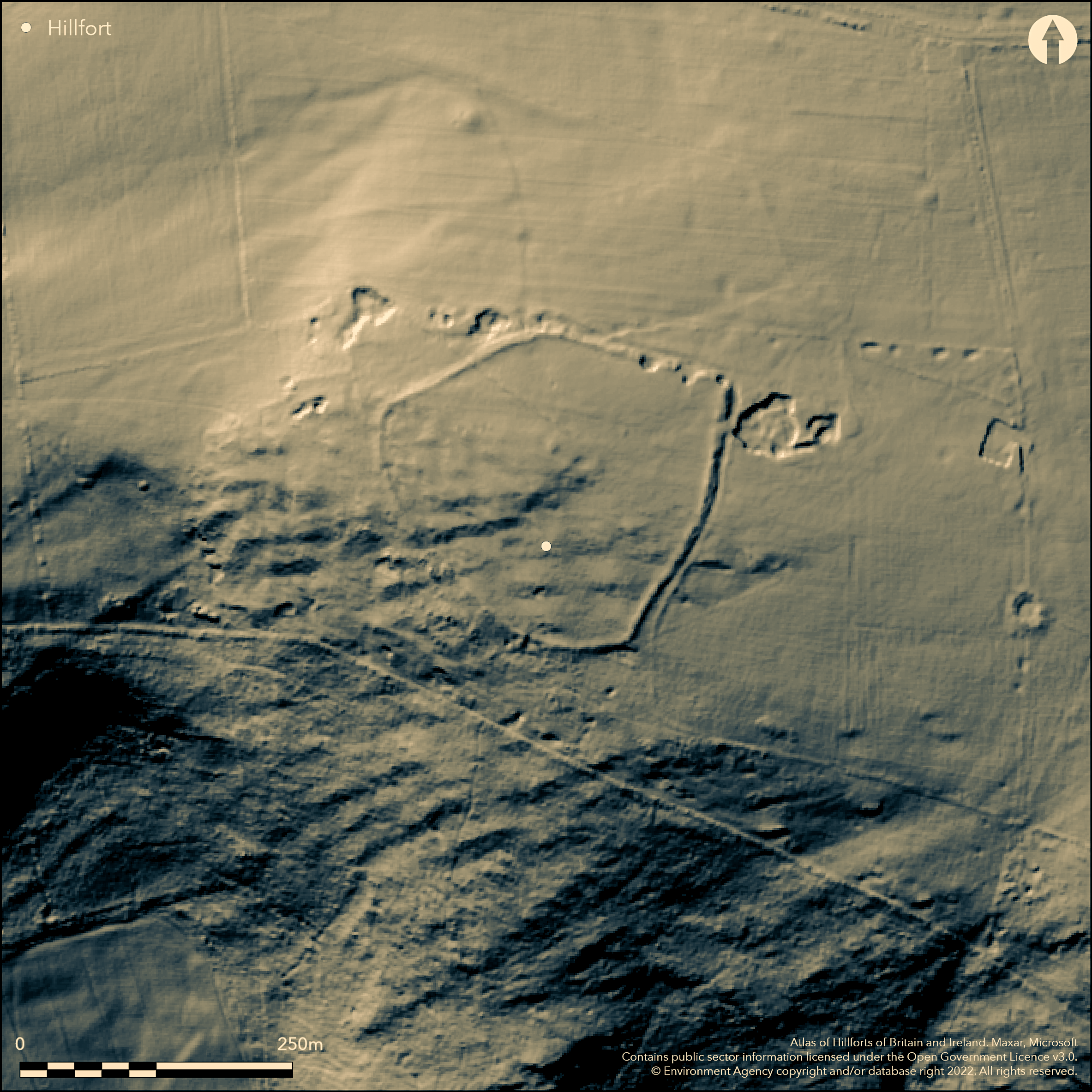
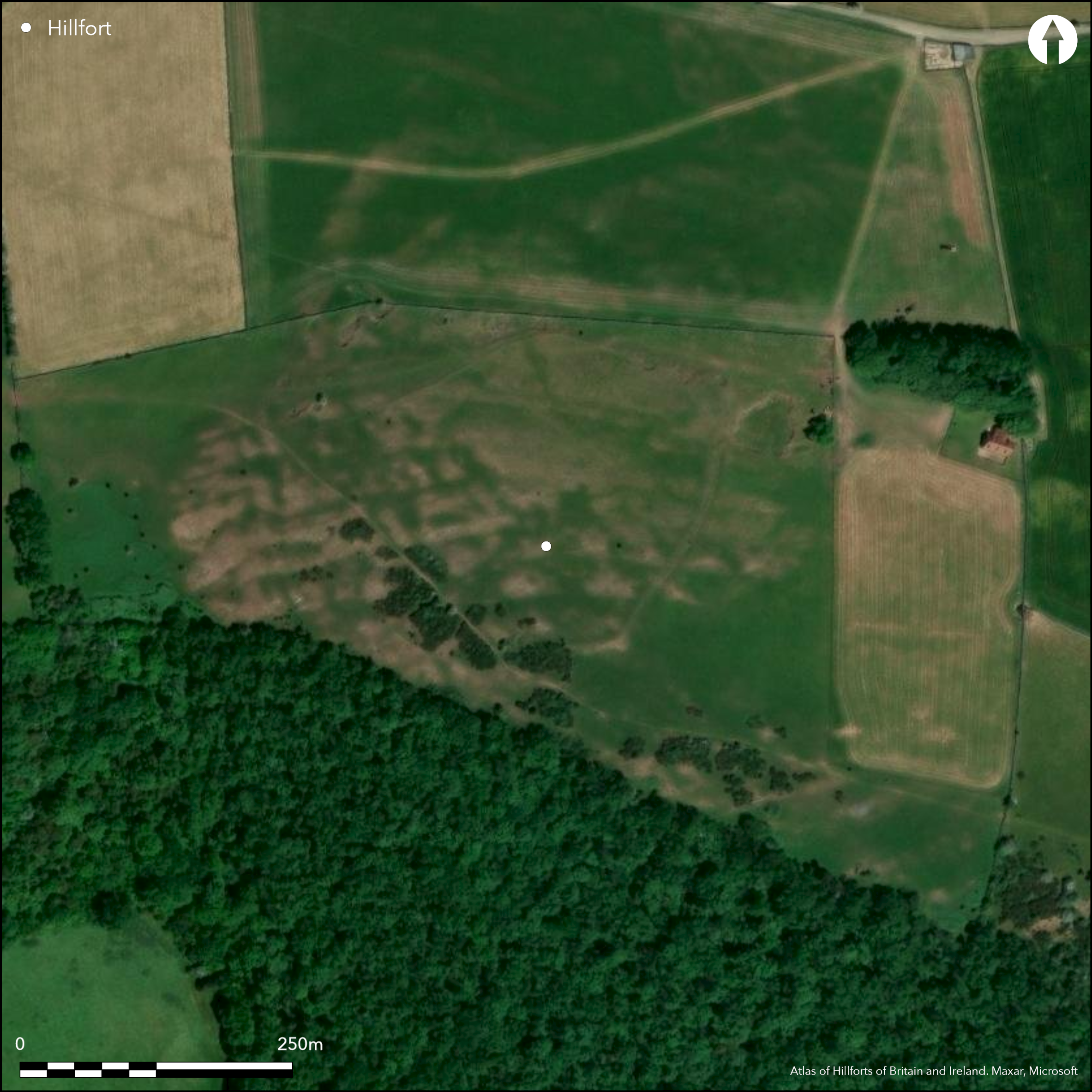
Slight univallate hillslope fort located at the edge of a limestone plateau on W side of Mendip. Very steep slopes to SW, level to modertate to E. Rocky outcrops in interior. On 2nd Ed OS map (1937-1961). Very narrow-topped bank some 0.7m-1m high, with external ditch 0.5m deep extends around higher N part of site, degenerating to a scarp on SW. Berm between bank and ditch on E side. Site much damaged by small quarries around perimeter and the narrow top to the bank suggests a dry-stone surrounding wall, possibly robbed for local field walls and limekiln outside entrance. E simple gap and causeway entrance c. 5m wide. This faces the plateau with its level/moderate approach. Small mounds in interior, one suggested as a round barrow, however all could be quarry spoil. Possible building platforms in interior. Linear banks outside and in interior are remnants of medieval field system; mistaken for an annexe in the past. The site has been suggested as unfinished, but there is insufficient evidence for this because of the recent quarry damage. Measured survey (Jamieson 2007). Undated.
Citizen Science: ✗
Reliability of Data: Confirmed
Reliability of Interpretation: Confirmed
X: -303834 Y: 6666833 (EPSG: 3857)
Longitude: -2.7293846839834646 Latitude: 51.25673487797308 (EPSG:4326)
Country: England
Current County or Unitary Authority: Somerset
Historic County: Somerset
Current Parish/Community/Council/Townland: Rodney Stoke
Damaged by limestone quarries.
| Extant | ✓ |
| Cropmark | ✗ |
| Likely Destroyed | ✗ |
Upland pasture. Bare rock outcrops.
| Woodland | ✗ |
| Commercial Forestry Plantation | ✗ |
| Parkland | ✗ |
| Pasture (Grazing) | ✓ |
| Arable | ✗ |
| Scrub/Bracken | ✗ |
| Bare Outcrop | ✗ |
| Heather/Moorland | ✗ |
| Heath | ✗ |
| Built-up | ✗ |
| Coastal Grassland | ✗ |
| Other | ✗ |
Slight univallate hillslope fort located at the edge of a limestone plateau on the W side of Mendip.
| Contour Fort | ✗ |
| Partial Contour Fort | ✗ |
| Promontory Fort | ✗ |
| Hillslope Fort | ✓ |
| Level Terrain Fort | ✗ |
| Marsh Fort | ✗ |
| Multiple Enclosure Fort | ✗ |
Prominent hilltop position
| Hilltop | ✗ |
| Coastal Promontory | ✗ |
| Inland Promontory | ✗ |
| Valley Bottom | ✗ |
| Knoll/Hillock/Outcrop | ✗ |
| Ridge | ✗ |
| Cliff/Plateau-edge/Scarp | ✓ |
| Hillslope | ✓ |
| Lowland | ✗ |
| Spur | ✓ |
Dominant Topographic Feature: Limestone plateau
| North | ✗ |
| Northeast | ✗ |
| East | ✗ |
| Southeast | ✗ |
| South | ✗ |
| Southwest | ✓ |
| West | ✗ |
| Northwest | ✗ |
| Level | ✗ |
Altitude: 260.0m
N/A
None
Reliability: D - None
| Pre 1200BC | ✗ |
| 1200BC - 800BC | ✗ |
| 800BC - 400BC | ✗ |
| 400BC - AD50 | ✗ |
| AD50 - AD400 | ✗ |
| AD400 - AD 800 | ✗ |
| Post AD800 | ✗ |
| Unknown | ✓ |
| Pre Hillfort: | None |
| Post Hillfort: | None |
On 2nd Ed OS map (1937-1961). English Heritage Measured Survey 2007.
| Earthwork Survey (2007): | English Heritage Measured Survey 2007. |
| 1st Identified Map Depiction (None): | 2nd Ed OS |
Quarry scoops in interior; possible hut platforms.
None
| None | ✓ |
| Spring | ✗ |
| Stream | ✗ |
| Pool | ✗ |
| Flush | ✗ |
| Well | ✗ |
| Other | ✗ |
Quarry scoops in interior; possible hut platforms.
| No Known Features | ✗ |
| Round Stone Structures | ✗ |
| Rectangular Stone Structures | ✗ |
| Curvilinear Platforms | ✓ |
| Other Roundhouse Evidence | ✗ |
| Pits | ✗ |
| Quarry Hollows | ✓ |
| Other | ✗ |
None
| No Known Excavation | ✓ |
| Pits | ✗ |
| Postholes | ✗ |
| Roundhouses | ✗ |
| Rectangular Structures | ✗ |
| Roads/Tracks | ✗ |
| Quarry Hollows | ✗ |
| Other | ✗ |
| Nothing Found | ✗ |
None
| No Known Geophysics | ✓ |
| Pits | ✗ |
| Roundhouses | ✗ |
| Rectangular Structures | ✗ |
| Roads/Tracks | ✗ |
| Quarry Hollows | ✗ |
| Other | ✗ |
| Nothing Found | ✗ |
None
| No Known Finds | ✓ |
| Pottery | ✗ |
| Metal | ✗ |
| Metalworking | ✗ |
| Human Bones | ✗ |
| Animal Bones | ✗ |
| Lithics | ✗ |
| Environmental | ✗ |
| Other | ✗ |
None
| APs Not Checked | ✓ |
| None | ✗ |
| Roundhouses | ✗ |
| Rectangular Structures | ✗ |
| Pits | ✗ |
| Postholes | ✗ |
| Roads/Tracks | ✗ |
| Other | ✗ |
Simple gap entrance with causeway c. 5m wide.
| 1: | None |
| 2: | None |
Guard Chambers: ✗
Chevaux de Frise: ✗
| 1. Simple Gap (East): | Gap with causeway. |
Very narrow-topped bank some 0.7m-1m high, with external ditch 0.5m deep extends around the higher N part of the site, degenerating to a scarp on the SW. A berm between the bank and ditch on E side. The site has been much damaged by small quarries around the perimeter and the narrow top to the bank suggests a dry-stone surrounding wall, possibly robbed for local field walls and limekiln outside entrance.
| Area 1: | 2.4ha. |
| Total: | 2.4ha. |
Total Footprint Area: Noneha.
None
| ✗ | None |
| ✗ | S side degenerates to scarp. |
| NE Quadrant: | 1 |
| SE Quadrant: | 0 |
| SW Quadrant: | 0 |
| NW Quadrant: | 1 |
| Total: | 1 |
| Partial Univallate | ✓ |
| Univallate | ✗ |
| Partial Bivallate | ✗ |
| Bivallate | ✗ |
| Partial Multivallate | ✗ |
| Multivallate | ✗ |
| Unknown | ✗ |
| Partial Univallate | ✗ |
| Univallate | ✗ |
| Partial Bivallate | ✗ |
| Bivallate | ✗ |
| Partial Multivallate | ✗ |
| Multivallate | ✗ |
Site has been suggested as unfinished, but there is insufficient evidence for this because of the recent quarry damage.
| None | ✗ |
| Earthen Bank | ✗ |
| Stone Wall | ✗ |
| Rubble | ✓ |
| Wall-walk | ✗ |
| Evidence of Timber | ✗ |
| Vitrification | ✗ |
| Other Burning | ✗ |
| Palisade | ✗ |
| Counter Scarp Bank | ✗ |
| Berm | ✓ |
| Unfinished | ✓ |
| Other | ✗ |
None
| None | ✗ |
| Earthen Bank | ✗ |
| Stone Wall | ✗ |
| Murus Duplex | ✗ |
| Timber-framed | ✗ |
| Timber-laced | ✗ |
| Vitrification | ✗ |
| Other Burning | ✗ |
| Palisade | ✗ |
| Counter Scarp Bank | ✗ |
| Berm | ✗ |
| Unfinished | ✗ |
| No Known Excavation | ✓ |
| Other | ✗ |
| ✗ | None |
| ✓ | Very narrow-topped bank some 0.7-1m high, with external ditch 0.5m deep extends around the higher N part of the site, degenerating to a scarp on the SW. |
Number of Ditches: 1
| ✗ | Medieval field system linear banks mistaken for annexe. |
Jamieson, E. 2007. Westbury Camp, Somerset: a late -prehistoric hillfort on the Mendip Hills, Centre for Archaeology Report series Jamieson E/2007/ archaeological survey/Report No 71-2007, Swindon: English Heritage.
Atlas of Hillforts:
Wikidata:
This work is licensed under CC BY-SA 4.0![]()
![]()
![]() and should be cited as:
and should be cited as:
Lock, Gary and Ralston, Ian. 2024. Atlas of Hillforts of Britain and Ireland. Available at: https://hillforts.arch.ox.ac.uk
Document Version 1.1