LiDAR 1m DTM Hillshade
Satellite Imagery
LiDAR 1m DTM Hillshade
Satellite Imagery
Scroll left/right to view further images.
HER: Northumberland 1448 (None)
NMR: NT 92 NW 62 (3135)
SM: 1006561
NGR: NT 9280 2931
X: 392800 Y: 629310 (OSGB36)
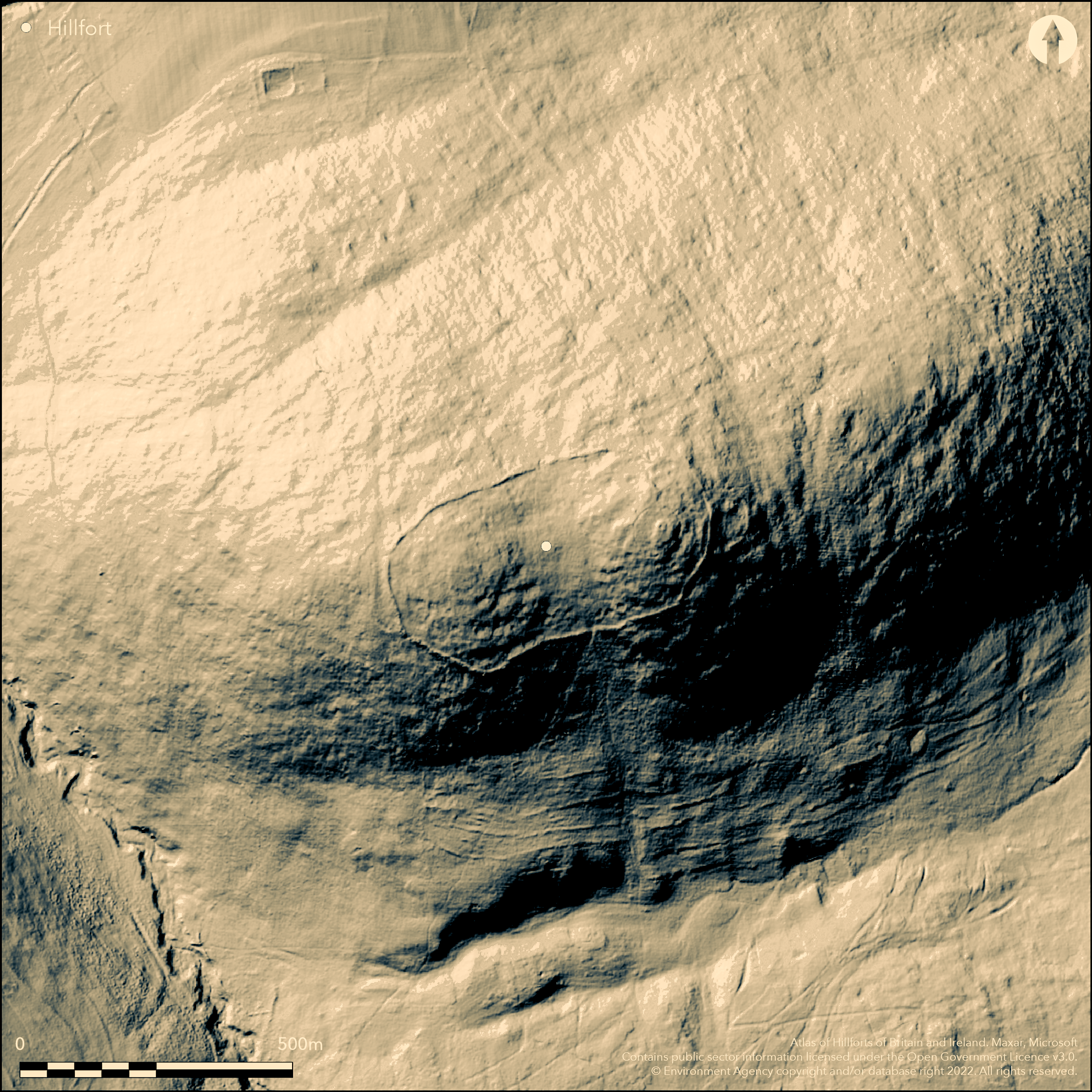
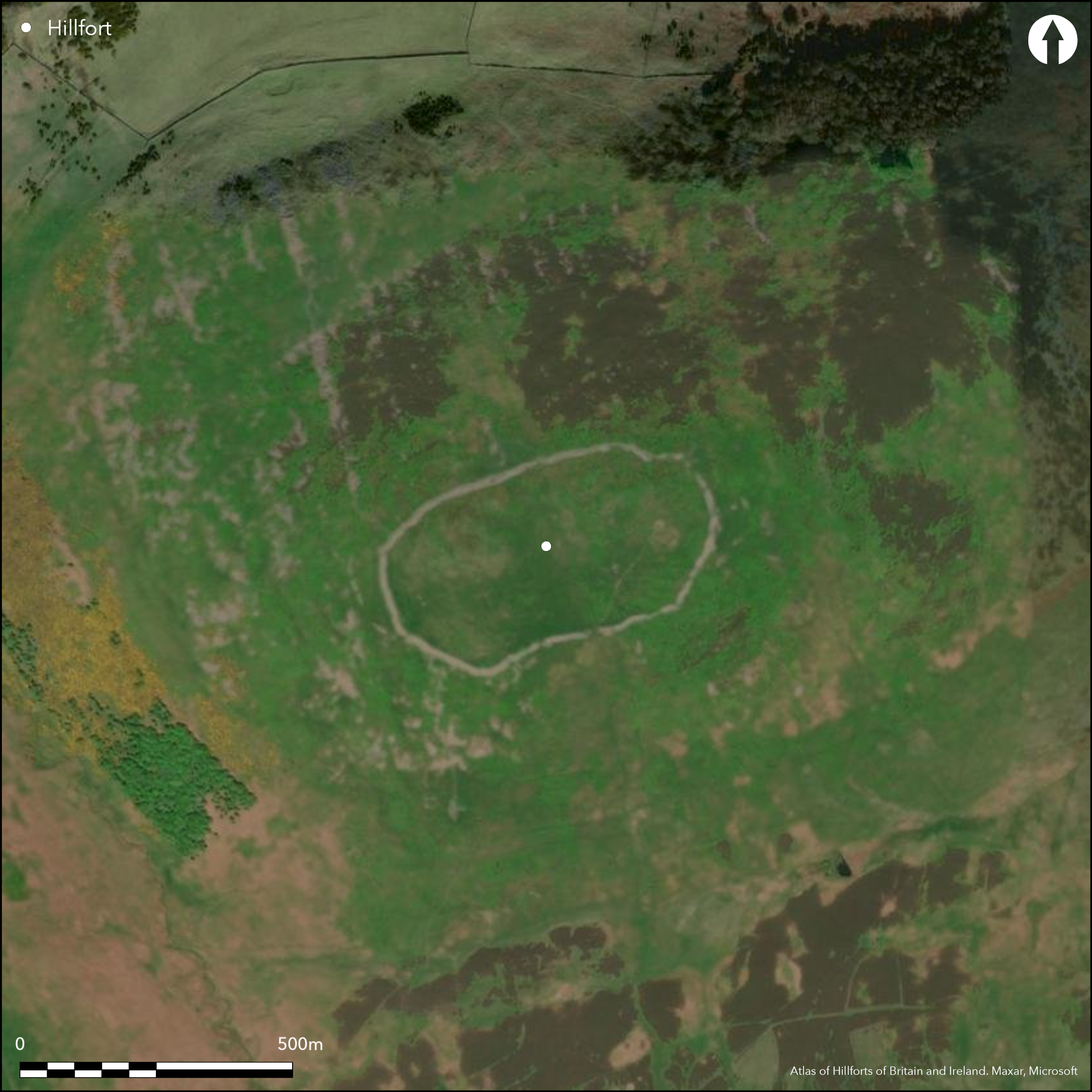
To the SE of KIrknewton in the Cheviot Hills, a large univallate stone-built hillfort, oval in form, with an internal area of 5.6ha.The site lies on the twin-peaked hill of Yeavering Bell at 355m OD, overlooking the River Glen. It is the largest hillfort in Northumberland and is conjectured to have been a tribal capital. A substantial, but now collapsed wall of rough stones encloses the summit of the hill. Excavation (Tate 1862) showed the wall was originally 3-3.5m thick, with a probable height of 2-2.5m which has now collapsed with a spread of 8-9m. There is some evidence that the bank was faced externally with a drystone wall. No ditch is evident. External crescent-shaped banks 102m long in the E and 130m long in the W, may represent an earlier line of defence, abandoned when the main enclosure was constructed. Stone walled shelters adjacent to and within the fort and gaps in the rampart are probably medieval or post medieval. There are four breaks within the enclosure wall with the slightly in-turned entrance in the S considered to be the only original entrance. In the region of 125 timber built roundhouse platforms have been identified within the interior, with further sub-surface features expected to survive. The stone for the walling was probably sourced from the hill as suggested by quarry hollows within the interior. A natural, but artificially levelled mound at the eastern summit of the hillfort with an encircling rock cut ditch enclosing 1.9ha has been shown to cut through roundhouse platforms (Oswald and Pearson, 2005) confirming it to be a later feature. Within it a mound of reddened stones has been interpreted by investigators variously as a beacon or cairn. The hillfort has seen a number of investigations, the earliest in the 19th century (Tate 1862) when a quernstone, jasper ball of around 7.5cm diameter, charred wood, coarse pottery, unworked flints and polished oak rings described as armlets were recovered. An excavation in 1958 (Hope-Taylor 1977) investigated the N side of the eastern summit as well as the southern entrance and what was considered at the time to be the northern entrance. A plan was published by Jobey in 1965 and description in 1966 and further surveys were carried out by RCHME in 1986 and 1998 including a geophysical survey. The main phase of the hillfort is thought to date to the third century BC, with possible short-lived or transitory Roman activity. The site is shown on Armstrong's map of Northumberland 1769 and recorded on 1882-1900 1st edition OS mapping
Citizen Science: ✗
Reliability of Data: Confirmed
Reliability of Interpretation: Confirmed
X: -235518 Y: 7470818 (EPSG: 3857)
Longitude: -2.115692846972957 Latitude: 55.557459217245 (EPSG:4326)
Country: England
Current County or Unitary Authority: Northumberland
Historic County: Northumberland
Current Parish/Community/Council/Townland: Kirknewton
In 1998 a pilot archaeological survey project at Yeavering Bell resulted in a 25-year Management Agreement with the landowner to protect all the archaeologically sensitive areas.
| Extant | ✓ |
| Cropmark | ✗ |
| Likely Destroyed | ✗ |
Rough grassland, possibly grazed
| Woodland | ✗ |
| Commercial Forestry Plantation | ✗ |
| Parkland | ✗ |
| Pasture (Grazing) | ✓ |
| Arable | ✗ |
| Scrub/Bracken | ✗ |
| Bare Outcrop | ✗ |
| Heather/Moorland | ✗ |
| Heath | ✗ |
| Built-up | ✗ |
| Coastal Grassland | ✗ |
| Other | ✗ |
A large univallate contour fort situated at 355m OD enclosing the twin summits of Yeavering Bell. The name 'Yeavering' derives from Gefrin 'the hill of the goats'.
| Contour Fort | ✓ |
| Partial Contour Fort | ✗ |
| Promontory Fort | ✗ |
| Hillslope Fort | ✗ |
| Level Terrain Fort | ✗ |
| Marsh Fort | ✗ |
| Multiple Enclosure Fort | ✗ |
| Hilltop | ✓ |
| Coastal Promontory | ✗ |
| Inland Promontory | ✗ |
| Valley Bottom | ✗ |
| Knoll/Hillock/Outcrop | ✗ |
| Ridge | ✗ |
| Cliff/Plateau-edge/Scarp | ✗ |
| Hillslope | ✗ |
| Lowland | ✗ |
| Spur | ✗ |
Dominant Topographic Feature: Twin summits
| North | ✗ |
| Northeast | ✗ |
| East | ✗ |
| Southeast | ✗ |
| South | ✗ |
| Southwest | ✗ |
| West | ✗ |
| Northwest | ✗ |
| Level | ✓ |
Altitude: 355.0m
N/A
The form of the roundhouse platforms are generally accepted as being late Bronze Age or early Iron Age. Finds from excavations raised the possibility of some occupation continuing into the 2nd century AD. More recently fragments of Samian Ware and late Roman coins have been discovered. The detail of Iron Age discoveries made by Hope-Taylor were never fully published
Reliability: B - Medium
| Pre 1200BC | ✗ |
| 1200BC - 800BC | ✗ |
| 800BC - 400BC | ✓ |
| 400BC - AD50 | ✓ |
| AD50 - AD400 | ✗ |
| AD400 - AD 800 | ✗ |
| Post AD800 | ✗ |
| Unknown | ✗ |
| Pre Hillfort: | None |
| Post Hillfort: | None |
| Artefactual: | Quernstone, jasper ball of around 7.5cm diameter, charred wood, coarse pottery, unworked flints polished oak rings |
| Artefactual: | Sherds of Roman Samianware and low denomination late Roman coins. Now lost and the context is unrecorded |
| Morphology/Earthwork/Typology: | None |
General reference to 'Ad Gefrin' in Bede's Ecclesiastical History of the English People c.761. Excavations by Tate (1863) and Hope-Taylor (1958). Geophysical survey and measured survey in 1998. Analytical survey and reinterpretation in 1999 at the request of the Northumberland National Park Authority. Field investigations in 1955, 1969 and 1976. 1965 Field survey by G Jobey. The site is shown on Armstrong's map of Northumberland 1769. Recorded on 1882-1900 OS mapping. Schedled
| 1st Identified Map Depiction (1769): | Armstrong's map of Northumberland |
| Other (1861): | Plan drawn in 1861 prior to excavation (Tate) |
| Excavation (1863): | Tate (1863) |
| Other (1955): | Field investigation |
| Excavation (1958): | Hope-Taylor |
| Other (1965): | Field survey (G. Jobey) |
| Other (1969): | Field investigation |
| Other (1976): | Field investigation |
| Other (1978): | Field investigation |
| Geophysical Survey (1998): | Ancient Monuments Laboratory |
| Earthwork Survey (1998): | Measured Survey - RCHME Yeavering Bell Hillfort Survey |
| Other (1999): | Analytical Survey 'Discovering our Hillfort Heritage' Project |
| Other (2002): | Visited by Hillfort Study Group |
| 1st Identified Written Reference (None): | Bede Ecclesiastical History of the English People |
| Earthwork Survey (None): | Milfield Geoarchaeology Project |
| Other (None): | Scheduled |
Platforms for 125 timber built roundhouses. In the E, a natural mound which has been artificially levelled, with an encircling ditch, considered to post-date the main period of excavation. Timber and burning suggest it might have been a beacon. Pottery, metal and lithics found.
A small stream rises about 300m to the S-E on the more accessible side.
| None | ✓ |
| Spring | ✗ |
| Stream | ✗ |
| Pool | ✗ |
| Flush | ✗ |
| Well | ✗ |
| Other | ✗ |
A recent survey has identified 125 hut sites ranging in size from between 3-10m. More might survive below ground and amongst quarry scoops. The majority are identifiable from a platform cut into the hillside. Several have ring-grooves visible.
| No Known Features | ✗ |
| Round Stone Structures | ✓ |
| Rectangular Stone Structures | ✗ |
| Curvilinear Platforms | ✓ |
| Other Roundhouse Evidence | ✓ |
| Pits | ✗ |
| Quarry Hollows | ✓ |
| Other | ✗ |
None
| No Known Excavation | ✗ |
| Pits | ✗ |
| Postholes | ✗ |
| Roundhouses | ✓ |
| Rectangular Structures | ✗ |
| Roads/Tracks | ✗ |
| Quarry Hollows | ✗ |
| Other | ✗ |
| Nothing Found | ✗ |
None
| No Known Geophysics | ✓ |
| Pits | ✗ |
| Roundhouses | ✗ |
| Rectangular Structures | ✗ |
| Roads/Tracks | ✗ |
| Quarry Hollows | ✗ |
| Other | ✗ |
| Nothing Found | ✗ |
Jasper ball, quernstone, polished oak rings, charred wood
| No Known Finds | ✗ |
| Pottery | ✓ |
| Metal | ✓ |
| Metalworking | ✗ |
| Human Bones | ✗ |
| Animal Bones | ✗ |
| Lithics | ✓ |
| Environmental | ✗ |
| Other | ✓ |
None
| APs Not Checked | ✓ |
| None | ✗ |
| Roundhouses | ✗ |
| Rectangular Structures | ✗ |
| Pits | ✗ |
| Postholes | ✗ |
| Roads/Tracks | ✗ |
| Other | ✗ |
Slightly inturned entrance in the S, three other breaks probably later.
| 4: | None |
| 2: | None |
Guard Chambers: ✗
Chevaux de Frise: ✗
| 1. In-turned (South): | None |
The hillfort proper comprises a univallate wall of rough stones 3-3.5m thick with a probable height 2-2.5m and was possibly faced externally with a drystone wall, no ditch. Crescent-shaped banks in the E and W on the most accessible sides of the hill are considered to be an earlier phase of enclosure.
| Area 1: | 5.6ha. |
| Total: | 5.6ha. |
Total Footprint Area: 6.0ha.
None
| ✓ | None |
| ✓ | Crescent-shaped banks in the E and W on the most accessible sides of the hill are considered to be an earlier phase of enclosure. |
| NE Quadrant: | 1 |
| SE Quadrant: | 1 |
| SW Quadrant: | 1 |
| NW Quadrant: | 1 |
| Total: | 1 |
| Partial Univallate | ✗ |
| Univallate | ✓ |
| Partial Bivallate | ✗ |
| Bivallate | ✗ |
| Partial Multivallate | ✗ |
| Multivallate | ✗ |
| Unknown | ✗ |
| Partial Univallate | ✗ |
| Univallate | ✗ |
| Partial Bivallate | ✗ |
| Bivallate | ✗ |
| Partial Multivallate | ✗ |
| Multivallate | ✗ |
None
| None | ✗ |
| Earthen Bank | ✗ |
| Stone Wall | ✓ |
| Rubble | ✓ |
| Wall-walk | ✗ |
| Evidence of Timber | ✗ |
| Vitrification | ✗ |
| Other Burning | ✗ |
| Palisade | ✗ |
| Counter Scarp Bank | ✗ |
| Berm | ✗ |
| Unfinished | ✗ |
| Other | ✗ |
Rough stone wall with possible drystone wall externally.
| None | ✗ |
| Earthen Bank | ✗ |
| Stone Wall | ✓ |
| Murus Duplex | ✗ |
| Timber-framed | ✗ |
| Timber-laced | ✗ |
| Vitrification | ✗ |
| Other Burning | ✗ |
| Palisade | ✗ |
| Counter Scarp Bank | ✗ |
| Berm | ✗ |
| Unfinished | ✗ |
| No Known Excavation | ✗ |
| Other | ✗ |
| ✗ | None |
| ✗ | None |
Number of Ditches: None
| ✗ | None |
English Heritage AML. 1998/Yeavering Bell Hillfort, Kirknewton: geophysical survey
Hope-Taylor, B. 1977 Yeavering: An Anglo-British centre of early Northumbria. London.
Jobey, G .1965. Hillforts and Settlements in Northumberland. Archaeol Aeliana (4th Series) 43
Oswald, A.W.P. and Pearson, T. 2005. Yeavering Bell hillfort, in Frodsham and O'Brien 2005, 98-126
Oswald, A, Ainsworth, A and Pearson, T, 2008. Iron Age hillforts in their landscape contexts: a fresh look at the field evidence in the Northumberland Cheviots. Arch Aeliana 5th series 37, 1-45
Oswald, A. Ainsworth, S. and Pearson, T 2006 Hillforts: Prehistoric Strongholds of Northumberland National Park. English Heritage
Pearson, T. 1998. Yeavering Bell Hillfort, Northumberland. RCHME, Swindon.
Tate, G. 1863. The antiquities of Yevering Bell and Three Stone Burn, among the Cheviots in Northumberland, with an account of excavations made into Celtic forts, hut dwellings, barrows and stone circles. Hist Berwickshire Natur Club 1856-62, 431-53
Atlas of Hillforts:
Wikidata:
This work is licensed under CC BY-SA 4.0![]()
![]()
![]() and should be cited as:
and should be cited as:
Lock, Gary and Ralston, Ian. 2024. Atlas of Hillforts of Britain and Ireland. Available at: https://hillforts.arch.ox.ac.uk
Document Version 1.1