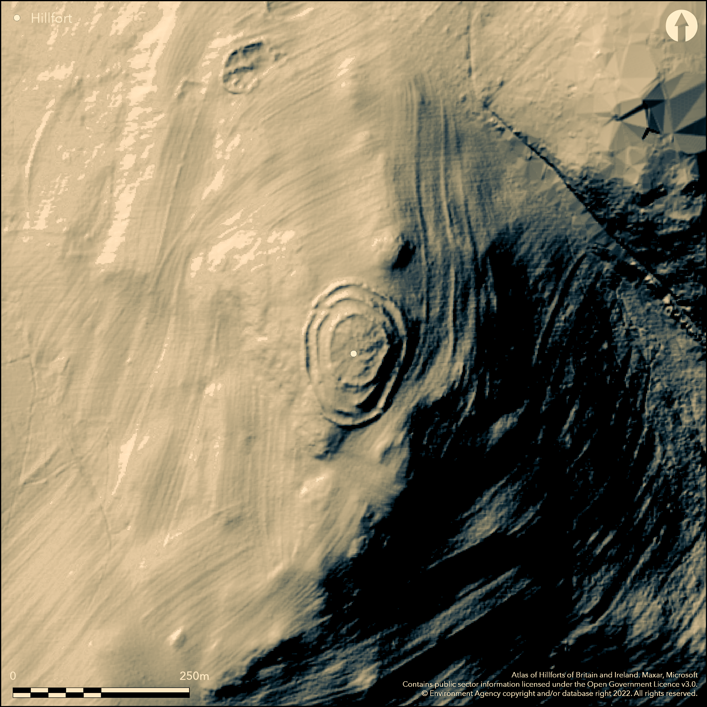
LiDAR 1m DTM Hillshade
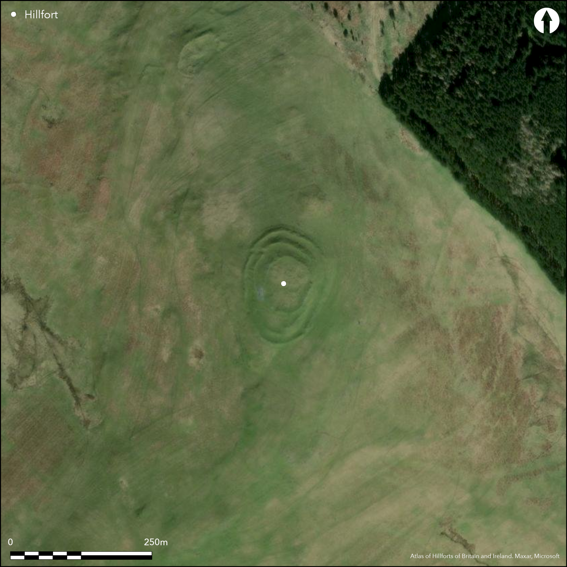
Satellite Imagery
LiDAR 1m DTM Hillshade
Satellite Imagery
Scroll left/right to view further images.
HER: Northumberland 588 (None)
NMR: NT 82 NE 24 (671)
SM: 1008364
NGR: NT 8670 2890
X: 386704 Y: 628900 (OSGB36)
Lying to the NW of Hethpool and within the Northumberland National Park, Ring Chesters is a multi-period hillfort of approximately 0.8ha in total, enclosed within a triple rampart. It is surrounded by steep slopes except in the S where the approach is relatively gentle. The earliest phase of the hillfort has been identified as a low, curving scarp underlying the phase three stone-built circuit. During a second phase two outer concentric earthen banks revetted by large stones enclosed an area of 0.41ha with staggered entrances in the SE and NW. A final phase of a smaller, circular stone-built circuit of 0.19ha was constructed within and partially overlying the line of the inner of the two earthen banks which was possibly razed or no longer maintained at that time (Oswald et al. 2008). Three courses of the final enclosure survive and are considered to have been a broad wall with an external face approximately 2m high with an entrance in the NW. There are traces of a ditch between the middle and outer ramparts, seen most clearly in the NW. The enclosures were remodelled in the Roman Iron Age and a number of low stone banks were constructed. In the W subdivisions within the space between the ramparts were possibly utilised as stock pens. The staggered entrances through the earthen ramparts were replaced by a single entrance in the stone rampart. Within the enclosure two phases of occupation have been identified; an earlier phase of one or two large circular ring-groove houses which are possibly contemporary with the bivallate or the later stone-built fort which succeeded it, and a later phase of seven smaller circular stone-founded ring-banks with courtyards and other subdivisions of the interior which are assumed to be Romano-British in date. The ramparts are now breached in several places. Field surveys were carried out by MacLauchlan and the Ordnance Survey (1860), Jobey (c.1965) and English Heritage (2001). The latter included a survey of 14.5ha within the environs of the hillfort which recorded prehistoric cultivation terraces and later features. There is no documentary record of excavation although possible former trenches have been identified. The site is recorded on 1856-65 OS mapping
Citizen Science: ✗
Reliability of Data: Confirmed
Reliability of Interpretation: Confirmed
X: -246274 Y: 7470068 (EPSG: 3857)
Longitude: -2.2123129071560794 Latitude: 55.55364586901619 (EPSG:4326)
Country: England; None
Current County or Unitary Authority: Northumberland
Historic County: Northumberland
Current Parish/Community/Council/Townland: Kilham; Kirknewton
Survives in good condition
| Extant | ✓ |
| Cropmark | ✗ |
| Likely Destroyed | ✗ |
None
| Woodland | ✗ |
| Commercial Forestry Plantation | ✗ |
| Parkland | ✗ |
| Pasture (Grazing) | ✓ |
| Arable | ✗ |
| Scrub/Bracken | ✗ |
| Bare Outcrop | ✗ |
| Heather/Moorland | ✗ |
| Heath | ✗ |
| Built-up | ✗ |
| Coastal Grassland | ✗ |
| Other | ✗ |
A multivallate contour fort situated at 341m OD.
| Contour Fort | ✓ |
| Partial Contour Fort | ✗ |
| Promontory Fort | ✗ |
| Hillslope Fort | ✗ |
| Level Terrain Fort | ✗ |
| Marsh Fort | ✗ |
| Multiple Enclosure Fort | ✗ |
| Hilltop | ✓ |
| Coastal Promontory | ✗ |
| Inland Promontory | ✗ |
| Valley Bottom | ✗ |
| Knoll/Hillock/Outcrop | ✗ |
| Ridge | ✗ |
| Cliff/Plateau-edge/Scarp | ✗ |
| Hillslope | ✗ |
| Lowland | ✗ |
| Spur | ✗ |
Dominant Topographic Feature: N end of the hilltop which is separated into two areas of high ground by a gently sloping saddle
| North | ✗ |
| Northeast | ✗ |
| East | ✗ |
| Southeast | ✗ |
| South | ✗ |
| Southwest | ✗ |
| West | ✗ |
| Northwest | ✗ |
| Level | ✓ |
Altitude: 341.0m
Parish boundary between Kilham and Kirknewton runs to the E
Boundary Type: Parish/Townland
The form of the enclosure is most probably Iron Age origin with later Romano-British settlement suggested by the stone-founded ring banks and yards.
Reliability: D - None
| Pre 1200BC | ✗ |
| 1200BC - 800BC | ✗ |
| 800BC - 400BC | ✗ |
| 400BC - AD50 | ✗ |
| AD50 - AD400 | ✗ |
| AD400 - AD 800 | ✗ |
| Post AD800 | ✗ |
| Unknown | ✓ |
| Pre Hillfort: | None |
| Post Hillfort: | Overlain by late Iron Age or Romano-British settlement |
| Morphology/Earthwork/Typology: | None |
Recorded on 1856-65 OS mapping. General reference in MacLauchlan 1919. Field Survey Jobey (c. 1965). Field investigation in 1955. Surveyed in 2001 by English Heritage as part of the 'Discovering our Hillfort Heritage' Project (Pearson et al. 2002). No record of excavation although possible trenches have been identified. Scheduled as a defended settlement
| Earthwork Survey (1860): | MacLauchlan (1860) |
| 1st Identified Written Reference (1919): | None |
| Other (1955): | Field investigation |
| Other (1968): | Scheduled |
| Earthwork Survey (2001): | 'Discovering our Hillfort Heritage' Project |
| Other (2002): | Visited by Hillfort Study Group |
| 1st Identified Map Depiction (None): | OS one-inch |
Circular stone foundations incorporating medium to large boulders, of at least eight buildings 4-8m in diameter with walls surviving up to 0.5m high. Two of the buildings have small areas of laid stone which are possibly hearths. A number of stone and earth banks form enclosures and sub-divisions within the interior of the settlement. At least two clearly defined scooped areas represent traces of earlier timber buildings.
None
| None | ✓ |
| Spring | ✗ |
| Stream | ✗ |
| Pool | ✗ |
| Flush | ✗ |
| Well | ✗ |
| Other | ✗ |
Stone round-houses are probably Late Iron Age or Romano-British
| No Known Features | ✗ |
| Round Stone Structures | ✓ |
| Rectangular Stone Structures | ✗ |
| Curvilinear Platforms | ✓ |
| Other Roundhouse Evidence | ✗ |
| Pits | ✗ |
| Quarry Hollows | ✗ |
| Other | ✓ |
No record of excavation although possible trenches have been identified
| No Known Excavation | ✗ |
| Pits | ✗ |
| Postholes | ✗ |
| Roundhouses | ✗ |
| Rectangular Structures | ✗ |
| Roads/Tracks | ✗ |
| Quarry Hollows | ✗ |
| Other | ✗ |
| Nothing Found | ✓ |
None
| No Known Geophysics | ✓ |
| Pits | ✗ |
| Roundhouses | ✗ |
| Rectangular Structures | ✗ |
| Roads/Tracks | ✗ |
| Quarry Hollows | ✗ |
| Other | ✗ |
| Nothing Found | ✗ |
None
| No Known Finds | ✓ |
| Pottery | ✗ |
| Metal | ✗ |
| Metalworking | ✗ |
| Human Bones | ✗ |
| Animal Bones | ✗ |
| Lithics | ✗ |
| Environmental | ✗ |
| Other | ✗ |
Black and white photographs taken by Gates (1985; 1986; 1997; 2000) record the monument and the extent of the presumed prehistoric cultivation terraces surrounding it.
| APs Not Checked | ✗ |
| None | ✗ |
| Roundhouses | ✓ |
| Rectangular Structures | ✗ |
| Pits | ✗ |
| Postholes | ✗ |
| Roads/Tracks | ✗ |
| Other | ✓ |
Main entrance in SE. Simple gaps 3.5-6m wide, staggered to give an oblique approach to the interior. Entrance through the middle rampart is out-turned on the S side and in-turned on the N side. The S edge defined by three large boulders which extend into the ditch. A further narrower gap entrance 3-3.5m wide cuts through the NW phase 2 ramparts. Entrance in NW in final phase enclosure continuing the oblique approach
| None: | Several |
| 2: | Multi-phase |
Guard Chambers: ✗
Chevaux de Frise: ✗
| 1. Oblique (South east): | Outer rampart, phase 2 |
| 2. Out-turned (South east): | Out-turned on S side, middle rampart, phase 2 |
| 2. In-turned (South east): | In-turned on N side, middle rampart, phase 2 |
| 2. Oblique (South east): | Staggered at acute angle, middle and outer rampart, phase 2 |
| 3. Oblique (North west): | Outer rampart, phase 2 |
| 4. Oblique (North west): | Middle rampart, phase 2 |
| 5. Oblique (North west): | Inner rampart, phase 3 |
The earliest phase of the hillfort has been identified as a low, curving scarp underlying the central stone-built circuit constructed mainly of small loose stones. It stands 4-5m wide and approximately 0.3m high internally and approximately 2m above the top of the centre rampart. The base of the rampart is reveted by large boulders in places. Some damage has occurred in the W. Middle rampart 4-5m wide, approximately 0.3m high standing 3m above the top of the outer rampart. Some levelling has occurred in the E and SE. The two ramparts are approximately 6m apart except in the S where it projects outwards by 18.5m enclosing an area of level ground of 0.07ha. The outer rampart is equidistant from the middle rampart at 7-8m and is 0.2-0.6m high internally and approximately 1m high on the exterior. Traces of a ditch between the middle and outer ramparts, seen most clearly in the NW.
| Area 1: | 0.07ha. |
| Area 2: | 0.41ha. |
| Area 3: | 0.19ha. |
| Total: | 0.41ha. |
Total Footprint Area: 0.8ha.
None
| ✓ | None |
| ✓ | None |
| NE Quadrant: | 3 |
| SE Quadrant: | 3 |
| SW Quadrant: | 3 |
| NW Quadrant: | 3 |
| Total: | 3 |
| Partial Univallate | ✗ |
| Univallate | ✗ |
| Partial Bivallate | ✗ |
| Bivallate | ✗ |
| Partial Multivallate | ✗ |
| Multivallate | ✓ |
| Unknown | ✗ |
| Partial Univallate | ✗ |
| Univallate | ✓ |
| Partial Bivallate | ✗ |
| Bivallate | ✓ |
| Partial Multivallate | ✗ |
| Multivallate | ✗ |
None
| None | ✗ |
| Earthen Bank | ✓ |
| Stone Wall | ✓ |
| Rubble | ✓ |
| Wall-walk | ✗ |
| Evidence of Timber | ✗ |
| Vitrification | ✗ |
| Other Burning | ✗ |
| Palisade | ✗ |
| Counter Scarp Bank | ✗ |
| Berm | ✗ |
| Unfinished | ✗ |
| Other | ✗ |
No record of excavation although possible trenches have been identified
| None | ✓ |
| Earthen Bank | ✗ |
| Stone Wall | ✗ |
| Murus Duplex | ✗ |
| Timber-framed | ✗ |
| Timber-laced | ✗ |
| Vitrification | ✗ |
| Other Burning | ✗ |
| Palisade | ✗ |
| Counter Scarp Bank | ✗ |
| Berm | ✗ |
| Unfinished | ✗ |
| No Known Excavation | ✗ |
| Other | ✗ |
| ✗ | None |
| ✓ | Traces of a ditch between the middle and outer ramparts, seen most clearly in the NW |
Number of Ditches: 1
| ✗ | None |
Jobey, G. 1965. Hill Forts and Settlements in Northumberland. Archaeologia Aeliana (4th Series) Volume: XLIII, 21-62.
MacLauchlan, H. 1919-22. Notes on camps in the parishes of Branxton, Carham, Ford, Kirknewton and Wooler in Northumberland. Hist Berwickshire Natur Club, 466-7
Oswald, A, Pearson, T and Ainsworth, S York. 2002. Ring Chesters, Northumberland: An Iron Age Hillfort and its Environs. English Heritage. Unpublished.
Oswald, A. Ainsworth, S. and Pearson, T 2006 Hillforts: Prehistoric Strongholds of Northumberland National Park. English Heritage
Oswald, A, Ainsworth, A and Pearson, T, 2008. Iron Age hillforts in their landscape contexts: a fresh look at the field evidence in the Northumberland cheviots'. Archaeologia Aeliana 5th series 37, 1-45
Atlas of Hillforts:
Wikidata:
This work is licensed under CC BY-SA 4.0

 and should be cited as:
Lock, Gary and Ralston, Ian. 2024. Atlas of Hillforts of Britain and Ireland. Available at: https://hillforts.arch.ox.ac.uk
Document Version 1.1