LiDAR 1m DTM Hillshade
Satellite Imagery
LiDAR 1m DTM Hillshade
Satellite Imagery
Scroll left/right to view further images.
HER: Northumberland 1332 (None)
NMR: NT 91 SE 3 (2230)
SM: 1006541
NGR: NT 9847 1489
X: 398470 Y: 614890 (OSGB36)
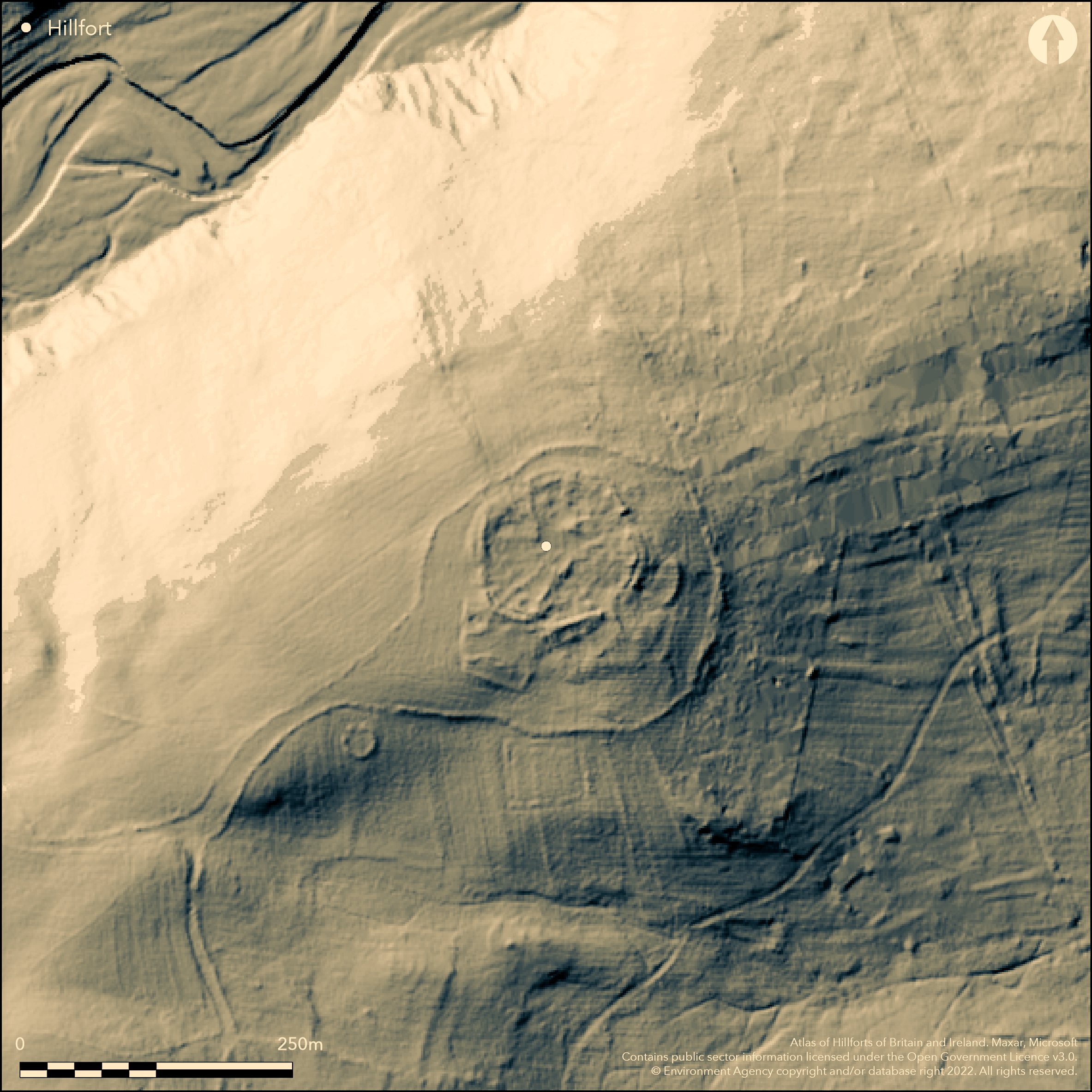
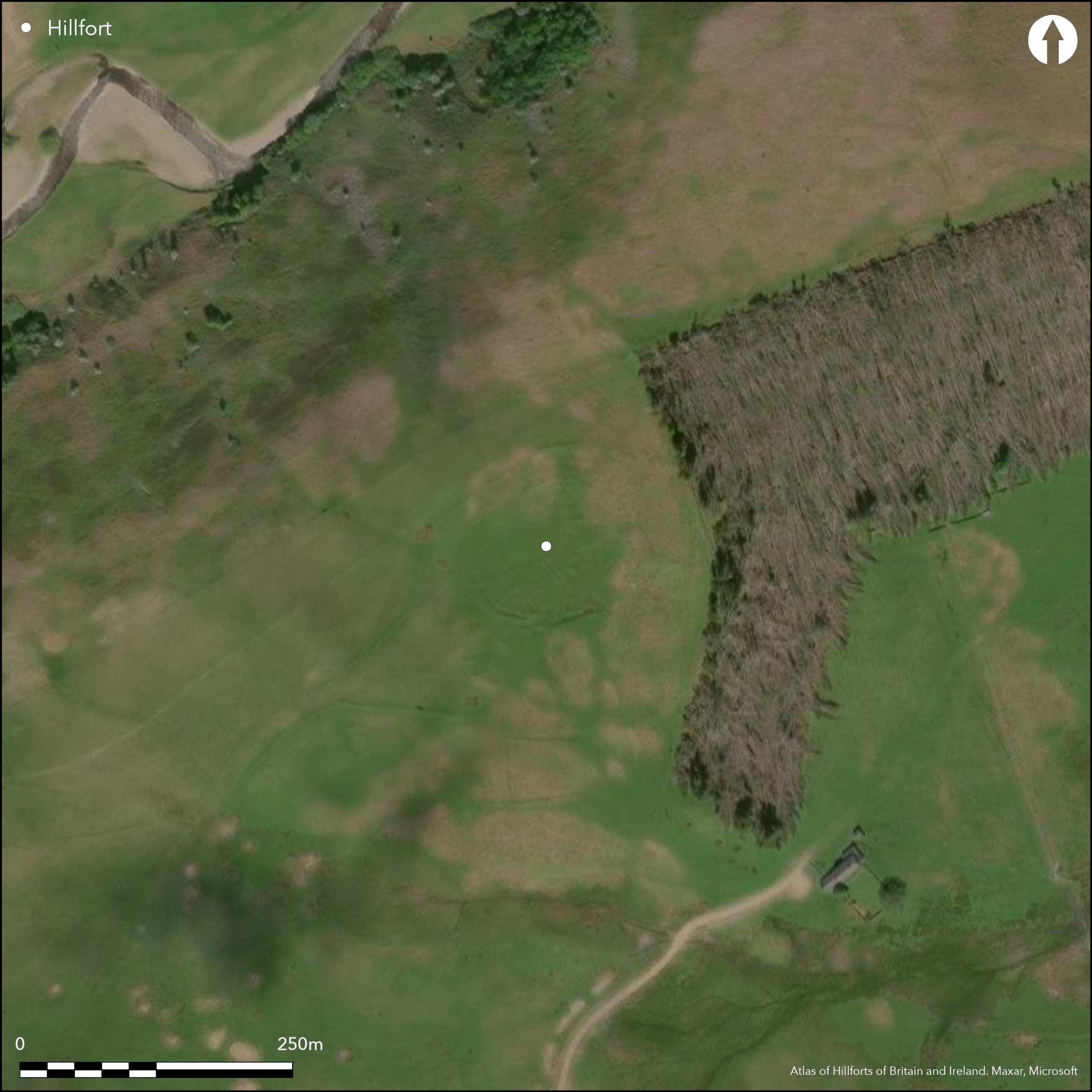
Lying to the S of the River Breamish and to the NE of the summit of Prickly Knowe, a sub-circular stone-built hillfort now mutilated and robbed. It lies on a gentle slope at 280m OD with ground falling away steeply to the N and E. Internally it measures 76m N-S by 81m E-W enclosing 0.4ha. Although enclosed by two ramparts the outer rampart opens in the W onto a later field system and was considered during an Ordnance Survey inspection to possibly be contemporary with that. This rampart, now the more mutilated of the two is visible as a low earthwork to the S and SE. Breaks around the course of the inner rampart in the N, NE SE and W are included in the scheduling as entrances, although the ramparts were considered too damaged to determine entrances by the SE Cheviots Project survey. Tate (1862) identified an entrance to the E associated with what he believed was a guard chamber, Maclauchlan (1867) also identified an entrance and guard chamber but located it in the S. Internally the remains of at least seven stone-founded hut circles and low earth banks forming internal divisions, are interpreted as a later Romano-British phase of occupation. Later shielings are also recorded. Excavations within the hillfort in 1861 (Tate 1862) produced broken pottery, charred wood and a flint 'spear or javelin head' from what he believed was the guardhouse and horse bones and stag horn from another part of enclosure. A roundhouse 8m W of the inner rampart produced broken pottery and burnt wood, a quern and a glass bead. The pottery, described as Votadinian or similar provides a date of 600-700 BC. Rectangular buildings range along the rampart in the S and include the remains of a small medieval settlement and associated stone-founded buildings. Stone from the ramparts was probably used in their construction. Embanked trackways approach the hillfort from the SW and continue around either side to enclose it in the NE. The site is recorded on 1856-65 OS mapping. It was surveyed by RCHME (Mackay 1989) as part of the SE Cheviots Project (Topping et al. 1988).
Citizen Science: ✗
Reliability of Data: Confirmed
Reliability of Interpretation: Confirmed
X: -225502 Y: 7445367 (EPSG: 3857)
Longitude: -2.0257212316823394 Latitude: 55.427938605992956 (EPSG:4326)
Country: England
Current County or Unitary Authority: Northumberland
Historic County: Northumberland
Current Parish/Community/Council/Townland: Alnham
Severely mutilated and robbed
| Extant | ✓ |
| Cropmark | ✗ |
| Likely Destroyed | ✗ |
None
| Woodland | ✗ |
| Commercial Forestry Plantation | ✗ |
| Parkland | ✗ |
| Pasture (Grazing) | ✓ |
| Arable | ✗ |
| Scrub/Bracken | ✗ |
| Bare Outcrop | ✗ |
| Heather/Moorland | ✗ |
| Heath | ✗ |
| Built-up | ✗ |
| Coastal Grassland | ✗ |
| Other | ✗ |
A hillslope fort lying at 280m OD to the NE of the summit of Prickly Knowe
| Contour Fort | ✗ |
| Partial Contour Fort | ✗ |
| Promontory Fort | ✗ |
| Hillslope Fort | ✓ |
| Level Terrain Fort | ✗ |
| Marsh Fort | ✗ |
| Multiple Enclosure Fort | ✗ |
| Hilltop | ✗ |
| Coastal Promontory | ✗ |
| Inland Promontory | ✗ |
| Valley Bottom | ✗ |
| Knoll/Hillock/Outcrop | ✗ |
| Ridge | ✗ |
| Cliff/Plateau-edge/Scarp | ✗ |
| Hillslope | ✓ |
| Lowland | ✗ |
| Spur | ✗ |
Dominant Topographic Feature: NE of the summit of Prickly Knowe
| North | ✗ |
| Northeast | ✓ |
| East | ✗ |
| Southeast | ✗ |
| South | ✗ |
| Southwest | ✗ |
| West | ✗ |
| Northwest | ✗ |
| Level | ✗ |
Altitude: 280.0m
N/A
600-700 BC pottery recovered during excavation of roundhouses and other features (Tate 1862)
Reliability: B - Medium
| Pre 1200BC | ✗ |
| 1200BC - 800BC | ✗ |
| 800BC - 400BC | ✓ |
| 400BC - AD50 | ✗ |
| AD50 - AD400 | ✗ |
| AD400 - AD 800 | ✗ |
| Post AD800 | ✗ |
| Unknown | ✗ |
| Pre Hillfort: | None |
| Post Hillfort: | None |
| Artefactual: | None |
Recorded on 1856-65 OS mapping. Excavations carried out by Tate and the Berwickshire Naturalists Club in 1861. OS Archaeology Division Field survey in 1957 and 1976. Field survey G. Jobey c.1965. Surveyed during the SE Cheviots Project in the 1980's, ref. no. 662366. Scheduled
| Excavation (1861): | Tate (1862) |
| 1st Identified Written Reference (1862): | Tate (1862) |
| Other (1934): | Scheduled |
| Other (1957): | Field investigation |
| Other (1965): | Field survey (G. Jobey) |
| Other (1976): | Field investigation |
| 1st Identified Map Depiction (None): | None |
| Earthwork Survey (None): | Mackay (1989) |
The remains of at least seven stone-founded hut circles and low earthen banks forming internal divisions, some of which are interpreted as a later Romano-British phase of occupation. Also rectangular structures, probably medieval or post-medieval shielings. Guard chambers were identified by Tate (1862) and MacLauchlan (1867). Range of finds from excavations including pottery, metal and animal bones.
A spring was recorded by MacLauchlan (1867) 61m to the S of the hillfort
| None | ✓ |
| Spring | ✗ |
| Stream | ✗ |
| Pool | ✗ |
| Flush | ✗ |
| Well | ✗ |
| Other | ✗ |
Stone founded and earthen walls. Stone round-houses are probably Late Iron Age or Romano-British. Rectangular structures are probably later shielings
| No Known Features | ✗ |
| Round Stone Structures | ✓ |
| Rectangular Stone Structures | ✓ |
| Curvilinear Platforms | ✗ |
| Other Roundhouse Evidence | ✗ |
| Pits | ✗ |
| Quarry Hollows | ✗ |
| Other | ✗ |
None
| No Known Excavation | ✗ |
| Pits | ✗ |
| Postholes | ✗ |
| Roundhouses | ✓ |
| Rectangular Structures | ✗ |
| Roads/Tracks | ✗ |
| Quarry Hollows | ✗ |
| Other | ✗ |
| Nothing Found | ✗ |
None
| No Known Geophysics | ✓ |
| Pits | ✗ |
| Roundhouses | ✗ |
| Rectangular Structures | ✗ |
| Roads/Tracks | ✗ |
| Quarry Hollows | ✗ |
| Other | ✗ |
| Nothing Found | ✗ |
Green glass bead
| No Known Finds | ✗ |
| Pottery | ✓ |
| Metal | ✓ |
| Metalworking | ✗ |
| Human Bones | ✗ |
| Animal Bones | ✓ |
| Lithics | ✓ |
| Environmental | ✗ |
| Other | ✓ |
None
| APs Not Checked | ✓ |
| None | ✗ |
| Roundhouses | ✗ |
| Rectangular Structures | ✗ |
| Pits | ✗ |
| Postholes | ✗ |
| Roads/Tracks | ✗ |
| Other | ✗ |
The rampart is too damaged to determine the location of entrances. Guard chambers associated with entrances were recorded by both Tate (1862) and Maclauchlan (1867) but the location differs
| 0: | None |
| 2: | None |
Guard Chambers: ✓
Chevaux de Frise: ✗
| 1. Recesses/Guard Chambers (None): | Location unknown |
81m E to W by 76m N to S enclosing 0.4ha. The inner earthen rampart is thought to be Iron Age in date, the outer stone rampart opens in the W onto a later field system and was considered during an Ordnance Survey inspection to possibly be contemporary with that. No ditch is recorded
| Area 1: | 0.4ha. |
| Total: | 0.4ha. |
Total Footprint Area: Noneha.
None
| ✓ | None |
| ✗ | Outer rampart opens in the W onto a later field system and was considered during an Ordnance Survey inspection to possibly be contemporary with that |
| NE Quadrant: | 2 |
| SE Quadrant: | 2 |
| SW Quadrant: | 1 |
| NW Quadrant: | 1 |
| Total: | 2 |
| Partial Univallate | ✓ |
| Univallate | ✗ |
| Partial Bivallate | ✓ |
| Bivallate | ✗ |
| Partial Multivallate | ✗ |
| Multivallate | ✗ |
| Unknown | ✗ |
| Partial Univallate | ✗ |
| Univallate | ✓ |
| Partial Bivallate | ✗ |
| Bivallate | ✗ |
| Partial Multivallate | ✗ |
| Multivallate | ✗ |
None
| None | ✗ |
| Earthen Bank | ✓ |
| Stone Wall | ✓ |
| Rubble | ✗ |
| Wall-walk | ✗ |
| Evidence of Timber | ✗ |
| Vitrification | ✗ |
| Other Burning | ✗ |
| Palisade | ✗ |
| Counter Scarp Bank | ✗ |
| Berm | ✗ |
| Unfinished | ✗ |
| Other | ✗ |
Excavations were carried out within the hillfort interior only
| None | ✗ |
| Earthen Bank | ✗ |
| Stone Wall | ✗ |
| Murus Duplex | ✗ |
| Timber-framed | ✗ |
| Timber-laced | ✗ |
| Vitrification | ✗ |
| Other Burning | ✗ |
| Palisade | ✗ |
| Counter Scarp Bank | ✗ |
| Berm | ✗ |
| Unfinished | ✗ |
| No Known Excavation | ✓ |
| Other | ✗ |
| ✗ | None |
| ✗ | None |
Number of Ditches: None
| ✗ | None |
Mackay D. 1989. SE Cheviots Project. 23-MAY-1989/RCHME. Unpublished
Jobey, G. 1965. Hillforts and Settlements in Northumberland. Archaeol Aeliana 43 63 No 90
MacLauchlan, H. 1867. Additional Notes to Roman Roads in Northumberland . 51-52
Tate, G. 1862. On the Old Celtic Town at Greaves Ash, near Linhope, Northumberland with an account of diggings recently made into this and other ancient remains in the valley of the Breamish. Hist Berwickshire Natur Club 4 (1856-62) 305-6
Topping, P. and Pearson, T. 1988. The South-East Cheviots Project: A Descriptive Account of the Prehistoric Landscape. Research Department Report Series no. 83-2003
Atlas of Hillforts:
Wikidata:
This work is licensed under CC BY-SA 4.0![]()
![]()
![]() and should be cited as:
and should be cited as:
Lock, Gary and Ralston, Ian. 2024. Atlas of Hillforts of Britain and Ireland. Available at: https://hillforts.arch.ox.ac.uk
Document Version 1.1