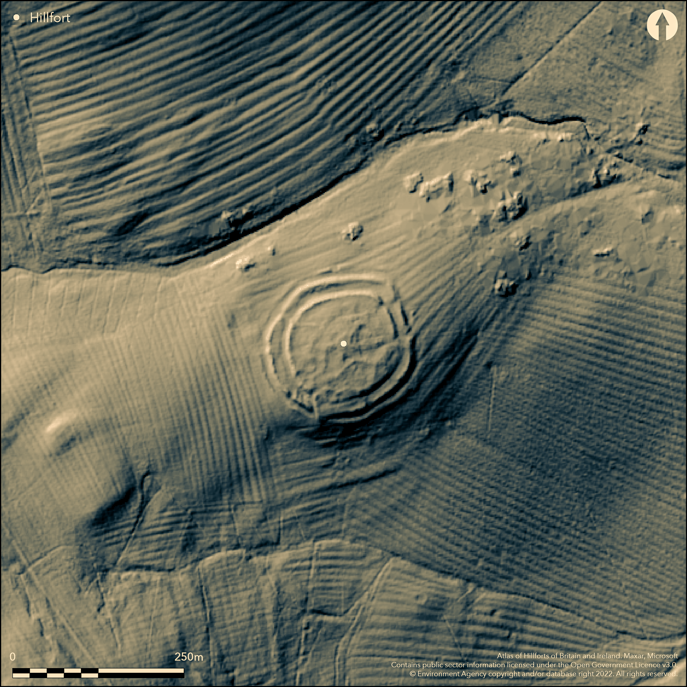
LiDAR 1m DTM Hillshade
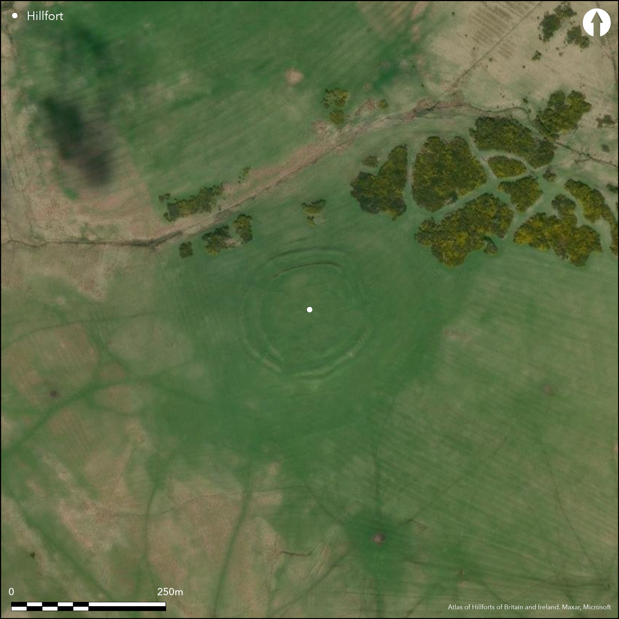
Satellite Imagery
LiDAR 1m DTM Hillshade
Satellite Imagery
Scroll left/right to view further images.
HER: Northumberland 3197 (None)
NMR: NU 01 SW 8 (5361)
SM: 1006545
NGR: NU 0243 1353
X: 402439 Y: 613532 (OSGB36)
Lying to 850m to the N of Great Ryle, within a bend of the Mere Burn, a probable hillfort of 0.4ha. Chubden Camp is almost circular in form with three concentric banks, the outermost of which has been almost destroyed by ridge and furrow ploughing. It lies on a slight knoll on the lower slopes of Chubden Hill and is overlooked by Old Fawdon (Atlas Number 0562), Gibbs Hill in the N and Chubden Pike in the S. The earth and stone banks have been formed by scarping the natural slope with the spoil used to form shallow banks on the top of the scarp. The inner bank measures 0.6-1.8m high and the middle bank 1-2m. The outer bank is just discernible at 0.2-0.5m in places. Entrances lie in the E as breaks through the middle and inner ramparts. The outer rampart is no longer visible in this area. A break in the SW is considered to be later disturbance. Internal divisions, possibly the remains of yards, are visible as low stone banks and three shallow depressions with stone walling the remains of houses which range in size from 4.5-8.5 m in diameter. A further ring bank 6m in diameter overlies the inner rampart. A rectangular building platform survives as an L-shaped bank 0.2m high and 2.5m wide. The internal earthworks are considered to be later. The site survives in good condition, but is unexcavated and undated but presumed Iron Age. Recorded on 1856-65 OS mapping
Citizen Science: ✗
Reliability of Data: Confirmed
Reliability of Interpretation: Confirmed
X: -218522 Y: 7442973 (EPSG: 3857)
Longitude: -1.9630178142460954 Latitude: 55.41573311815625 (EPSG:4326)
Country: England; None
Current County or Unitary Authority: Northumberland
Historic County: Northumberland
Current Parish/Community/Council/Townland: Alnham; Ingram
None
| Extant | ✓ |
| Cropmark | ✗ |
| Likely Destroyed | ✗ |
None
| Woodland | ✗ |
| Commercial Forestry Plantation | ✗ |
| Parkland | ✗ |
| Pasture (Grazing) | ✓ |
| Arable | ✗ |
| Scrub/Bracken | ✗ |
| Bare Outcrop | ✗ |
| Heather/Moorland | ✗ |
| Heath | ✗ |
| Built-up | ✗ |
| Coastal Grassland | ✗ |
| Other | ✗ |
A hillslope fort lying on a gentle slope at approximately 225m OD on a small knoll on Chubden Hill
| Contour Fort | ✗ |
| Partial Contour Fort | ✓ |
| Promontory Fort | ✗ |
| Hillslope Fort | ✓ |
| Level Terrain Fort | ✗ |
| Marsh Fort | ✗ |
| Multiple Enclosure Fort | ✗ |
| Hilltop | ✗ |
| Coastal Promontory | ✗ |
| Inland Promontory | ✗ |
| Valley Bottom | ✗ |
| Knoll/Hillock/Outcrop | ✗ |
| Ridge | ✗ |
| Cliff/Plateau-edge/Scarp | ✗ |
| Hillslope | ✓ |
| Lowland | ✗ |
| Spur | ✗ |
Dominant Topographic Feature: Knoll
| North | ✗ |
| Northeast | ✗ |
| East | ✗ |
| Southeast | ✗ |
| South | ✗ |
| Southwest | ✓ |
| West | ✗ |
| Northwest | ✗ |
| Level | ✗ |
Altitude: 225.0m
Parish boundary between Alnham and Ingram runs 70m to the N
Boundary Type: Parish/Townland
Undated, presumed Iron Age
Reliability: D - None
| Pre 1200BC | ✗ |
| 1200BC - 800BC | ✗ |
| 800BC - 400BC | ✗ |
| 400BC - AD50 | ✗ |
| AD50 - AD400 | ✗ |
| AD400 - AD 800 | ✗ |
| Post AD800 | ✗ |
| Unknown | ✓ |
| Pre Hillfort: | None |
| Post Hillfort: | Overlain by late Iron Age or Romano-British settlement |
| Morphology/Earthwork/Typology: | None |
General reference in MacLauchlan 1867. Recorded on 1856-65 OS mapping. Field investigations in 1957, 1970, 1976. Surveyed by RCHME/EH in the SE Cheviots Project, ref. no. 662366. Scheduled
| 1st Identified Written Reference (1867): | None |
| Other (1934): | Scheduled |
| Other (1957): | Field investigation |
| Other (1970): | Field investigation |
| Earthwork Survey (1976): | SE Cheviots Project. |
| Other (1976): | Field investigation |
| 1st Identified Map Depiction (None): | None |
Internal divisions, possibly the remains of yards, visible as low stone banks and three shallow depressions with stone walling represent the remains of houses. These range in size from 4.5-8.5 m in diameter. A further ring bank 6m in diameter overlies the inner rampart. A rectangular building platform survives as an L-shaped bank 0.2m high and 2.5m wide. All are considered to be later than the enclosing works
Mere Burn lies a few metres to the E
| None | ✓ |
| Spring | ✗ |
| Stream | ✗ |
| Pool | ✗ |
| Flush | ✗ |
| Well | ✗ |
| Other | ✗ |
Internal divisions and stone round-houses are probably Late Iron Age or Romano-British
| No Known Features | ✗ |
| Round Stone Structures | ✓ |
| Rectangular Stone Structures | ✓ |
| Curvilinear Platforms | ✗ |
| Other Roundhouse Evidence | ✗ |
| Pits | ✗ |
| Quarry Hollows | ✗ |
| Other | ✓ |
None
| No Known Excavation | ✓ |
| Pits | ✗ |
| Postholes | ✗ |
| Roundhouses | ✗ |
| Rectangular Structures | ✗ |
| Roads/Tracks | ✗ |
| Quarry Hollows | ✗ |
| Other | ✗ |
| Nothing Found | ✗ |
None
| No Known Geophysics | ✓ |
| Pits | ✗ |
| Roundhouses | ✗ |
| Rectangular Structures | ✗ |
| Roads/Tracks | ✗ |
| Quarry Hollows | ✗ |
| Other | ✗ |
| Nothing Found | ✗ |
None
| No Known Finds | ✓ |
| Pottery | ✗ |
| Metal | ✗ |
| Metalworking | ✗ |
| Human Bones | ✗ |
| Animal Bones | ✗ |
| Lithics | ✗ |
| Environmental | ✗ |
| Other | ✗ |
None
| APs Not Checked | ✓ |
| None | ✗ |
| Roundhouses | ✗ |
| Rectangular Structures | ✗ |
| Pits | ✗ |
| Postholes | ✗ |
| Roads/Tracks | ✗ |
| Other | ✗ |
Two breaks in the E through the inner and middle rampart. A break in the SW is probably later
| 3: | None |
| 2: | None |
Guard Chambers: ✗
Chevaux de Frise: ✗
| 1. Simple Gap (East): | Inner rampart |
| 2. Simple Gap (East): | MIddle rampart |
Originally three concentric banks approximately 90m in diameter. The outer rampart is now mainly destroyed
| Area 1: | 0.4ha. |
| Total: | 0.4ha. |
Total Footprint Area: Noneha.
None
| ✗ | None |
| ✓ | None |
| NE Quadrant: | 3 |
| SE Quadrant: | 3 |
| SW Quadrant: | 3 |
| NW Quadrant: | 3 |
| Total: | 3 |
| Partial Univallate | ✗ |
| Univallate | ✗ |
| Partial Bivallate | ✗ |
| Bivallate | ✗ |
| Partial Multivallate | ✗ |
| Multivallate | ✓ |
| Unknown | ✗ |
| Partial Univallate | ✗ |
| Univallate | ✗ |
| Partial Bivallate | ✗ |
| Bivallate | ✗ |
| Partial Multivallate | ✗ |
| Multivallate | ✗ |
None
| None | ✗ |
| Earthen Bank | ✓ |
| Stone Wall | ✗ |
| Rubble | ✓ |
| Wall-walk | ✗ |
| Evidence of Timber | ✗ |
| Vitrification | ✗ |
| Other Burning | ✗ |
| Palisade | ✗ |
| Counter Scarp Bank | ✗ |
| Berm | ✗ |
| Unfinished | ✗ |
| Other | ✗ |
None
| None | ✗ |
| Earthen Bank | ✗ |
| Stone Wall | ✗ |
| Murus Duplex | ✗ |
| Timber-framed | ✗ |
| Timber-laced | ✗ |
| Vitrification | ✗ |
| Other Burning | ✗ |
| Palisade | ✗ |
| Counter Scarp Bank | ✗ |
| Berm | ✗ |
| Unfinished | ✗ |
| No Known Excavation | ✓ |
| Other | ✗ |
| ✗ | None |
| ✗ | None |
Number of Ditches: None
| ✗ | None |
MacLauchlan, H. 1867. Additional Notes to Roman Roads in Northumberland (Newcastle upon Tyne), 55
Topping, P. and Pearson, T. 1988. The South-East Cheviots Project: A Descriptive Account of the Prehistoric Landscape. Research Department Report Series no. 83-2003
Atlas of Hillforts:
Wikidata:
This work is licensed under CC BY-SA 4.0

 and should be cited as:
Lock, Gary and Ralston, Ian. 2024. Atlas of Hillforts of Britain and Ireland. Available at: https://hillforts.arch.ox.ac.uk
Document Version 1.1