LiDAR 1m DTM Hillshade
Satellite Imagery
LiDAR 1m DTM Hillshade
Satellite Imagery
Scroll left/right to view further images.
HER: Northumberland 3607 (None)
NMR: NU 02 SE 9 (5753)
SM: 1006582
NGR: NU 0875 2199
X: 408750 Y: 621990 (OSGB36)
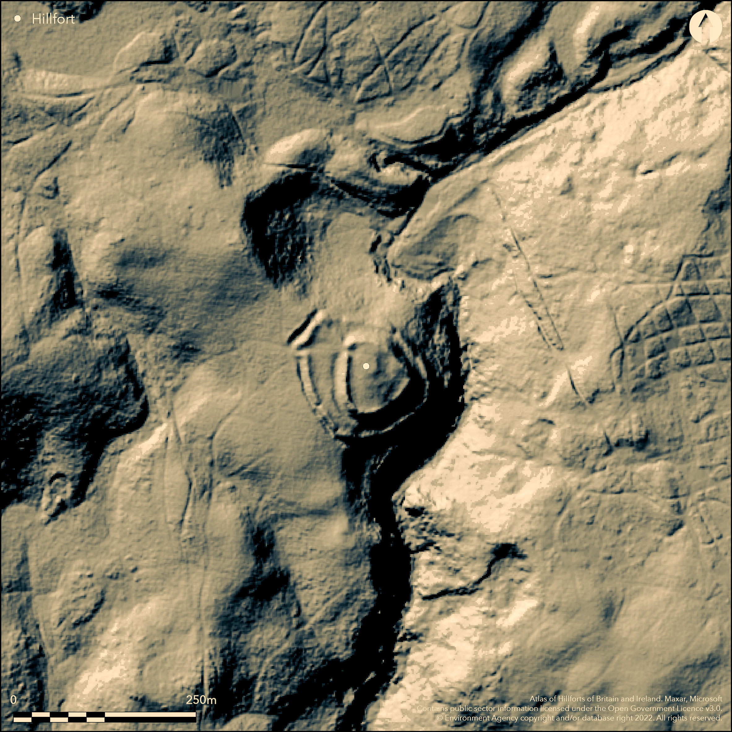
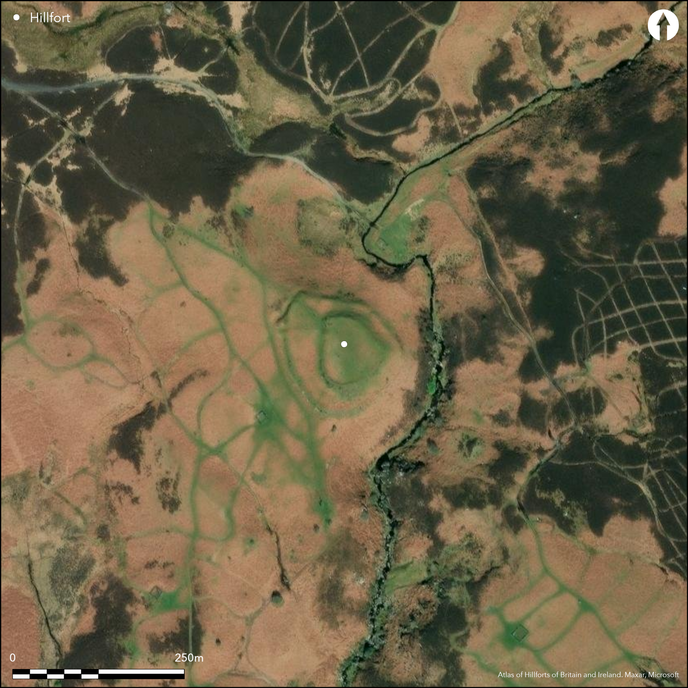
Lying 400m to the SE of Blawearie, overlooking Harehope Burn in the E, a small, multivallate hillfort lying on an artificially levelled natural knoll. At its maximum dimensions the hillfort measures 114m NW-SE by 92m transversely enclosing an area of 0.19ha and comprises two ramparts with a berm between. The substantial inner rampart is flanked in the W by a single eternal ditch 0.6m deep. The bank reaches a maximum height of 1.5m internally and 4.5m externally on its western side. Scarping on the remaining sides gives a maximum height of approximately 10m. The second, narrower outer bank is absent in the N where the ground falls away sharply. An external ditch protects the weaker area in the W and SW. A 7-20m wide berm separates the the inner and outer ramparts in the W and NW creating an additional enclosed area or annex. A single entrance lies in the NW of the outer rampart with slightly out-turned terminals. The bank of the northern terminal is thicker. A corresponding simple gap entrance cuts through the inner enclosure. The interior is bracken covered and no internal features are visible. The site is recorded on 1856-65 OS mapping but no excavation has taken place and is undated but presumed Iron Age.
Citizen Science: ✗
Reliability of Data: Confirmed
Reliability of Interpretation: Confirmed
X: -207395 Y: 7457879 (EPSG: 3857)
Longitude: -1.863064602811954 Latitude: 55.49166293319947 (EPSG:4326)
Country: England
Current County or Unitary Authority: Northumberland
Historic County: Northumberland
Current Parish/Community/Council/Townland: Bewick
Good preservation but vulnerable to stock erosion
| Extant | ✓ |
| Cropmark | ✗ |
| Likely Destroyed | ✗ |
None
| Woodland | ✗ |
| Commercial Forestry Plantation | ✗ |
| Parkland | ✗ |
| Pasture (Grazing) | ✗ |
| Arable | ✗ |
| Scrub/Bracken | ✓ |
| Bare Outcrop | ✗ |
| Heather/Moorland | ✗ |
| Heath | ✗ |
| Built-up | ✗ |
| Coastal Grassland | ✗ |
| Other | ✗ |
Lying at 187m OD, overlooking Harehope Burn, a multivallate hillfort occpying an artificially levelled knoll above a steep scarp.
| Contour Fort | ✗ |
| Partial Contour Fort | ✓ |
| Promontory Fort | ✗ |
| Hillslope Fort | ✗ |
| Level Terrain Fort | ✗ |
| Marsh Fort | ✗ |
| Multiple Enclosure Fort | ✗ |
| Hilltop | ✗ |
| Coastal Promontory | ✗ |
| Inland Promontory | ✗ |
| Valley Bottom | ✗ |
| Knoll/Hillock/Outcrop | ✓ |
| Ridge | ✗ |
| Cliff/Plateau-edge/Scarp | ✓ |
| Hillslope | ✗ |
| Lowland | ✗ |
| Spur | ✗ |
Dominant Topographic Feature: Artificially levelled knoll
| North | ✗ |
| Northeast | ✗ |
| East | ✗ |
| Southeast | ✓ |
| South | ✗ |
| Southwest | ✗ |
| West | ✗ |
| Northwest | ✗ |
| Level | ✗ |
Altitude: 187.0m
N/A
Undated, presumed Iron Age
Reliability: D - None
| Pre 1200BC | ✗ |
| 1200BC - 800BC | ✗ |
| 800BC - 400BC | ✗ |
| 400BC - AD50 | ✗ |
| AD50 - AD400 | ✗ |
| AD400 - AD 800 | ✗ |
| Post AD800 | ✗ |
| Unknown | ✓ |
| Pre Hillfort: | None |
| Post Hillfort: | None |
| Morphology/Earthwork/Typology: | None |
Shown on 1856-65 OS mapping. General reference in Dodds (1935); Field investigations visits 1955 and 1969. Scheduled
| 1st Identified Written Reference (1935): | None |
| Other (1955): | Field investigation |
| Other (1955): | Field investigation |
| 1st Identified Map Depiction (None): | None |
| Other (None): | Scheduled |
The interior is bracken-covered and the presence of internal features is unknown
Harehope Burn to the E
| None | ✓ |
| Spring | ✗ |
| Stream | ✗ |
| Pool | ✗ |
| Flush | ✗ |
| Well | ✗ |
| Other | ✗ |
Any surviving features are masked by bracken
| No Known Features | ✓ |
| Round Stone Structures | ✗ |
| Rectangular Stone Structures | ✗ |
| Curvilinear Platforms | ✗ |
| Other Roundhouse Evidence | ✗ |
| Pits | ✗ |
| Quarry Hollows | ✗ |
| Other | ✗ |
None
| No Known Excavation | ✓ |
| Pits | ✗ |
| Postholes | ✗ |
| Roundhouses | ✗ |
| Rectangular Structures | ✗ |
| Roads/Tracks | ✗ |
| Quarry Hollows | ✗ |
| Other | ✗ |
| Nothing Found | ✗ |
None
| No Known Geophysics | ✓ |
| Pits | ✗ |
| Roundhouses | ✗ |
| Rectangular Structures | ✗ |
| Roads/Tracks | ✗ |
| Quarry Hollows | ✗ |
| Other | ✗ |
| Nothing Found | ✗ |
None
| No Known Finds | ✓ |
| Pottery | ✗ |
| Metal | ✗ |
| Metalworking | ✗ |
| Human Bones | ✗ |
| Animal Bones | ✗ |
| Lithics | ✗ |
| Environmental | ✗ |
| Other | ✗ |
None
| APs Not Checked | ✓ |
| None | ✗ |
| Roundhouses | ✗ |
| Rectangular Structures | ✗ |
| Pits | ✗ |
| Postholes | ✗ |
| Roads/Tracks | ✗ |
| Other | ✗ |
A single entrance lies in the NW of the outer rampart with slightly out-turned terminals. The bank of the northern terminal is thicker. A corresponding simple gap entrance cuts through the inner enclosure.
| 2: | Single break through each rampart |
| 2: | None |
Guard Chambers: ✗
Chevaux de Frise: ✗
| 1. Simple Gap (North west): | Inner rampart |
| 2. Out-turned (North west): | Outer rampart |
Substantial inner rampart flanked in the W by a single eternal ditch 0.6m deep. The bank reaches a maximum height of 1.5m internally and 4.5m externally on its western side. Scarping on the remaining sides gives a maximum height of approximately 10m. The second, narrower outer bank is absent where the ground falls away sharply in the N. An external ditch protects the area in the W and SW where it is naturally weaker. A 7-20m wide berm separates the the inner and outer ramparts in the W and NW creating an additional enclosed area or annex.
| Area 1: | 0.19ha. |
| Total: | 0.19ha. |
Total Footprint Area: 1.04ha.
None
| ✗ | Estimated from satellite imagery |
| ✗ | Discontinuous lengths of bank and ditch |
| NE Quadrant: | 1 |
| SE Quadrant: | 2 |
| SW Quadrant: | 2 |
| NW Quadrant: | 2 |
| Total: | 2 |
| Partial Univallate | ✓ |
| Univallate | ✗ |
| Partial Bivallate | ✓ |
| Bivallate | ✗ |
| Partial Multivallate | ✗ |
| Multivallate | ✗ |
| Unknown | ✗ |
| Partial Univallate | ✗ |
| Univallate | ✗ |
| Partial Bivallate | ✗ |
| Bivallate | ✗ |
| Partial Multivallate | ✗ |
| Multivallate | ✗ |
Unrecorded, but reference to stone in the rampart banks suggests and earth and stone bank
| None | ✗ |
| Earthen Bank | ✓ |
| Stone Wall | ✗ |
| Rubble | ✓ |
| Wall-walk | ✗ |
| Evidence of Timber | ✗ |
| Vitrification | ✗ |
| Other Burning | ✗ |
| Palisade | ✗ |
| Counter Scarp Bank | ✗ |
| Berm | ✓ |
| Unfinished | ✗ |
| Other | ✗ |
None
| None | ✗ |
| Earthen Bank | ✗ |
| Stone Wall | ✗ |
| Murus Duplex | ✗ |
| Timber-framed | ✗ |
| Timber-laced | ✗ |
| Vitrification | ✗ |
| Other Burning | ✗ |
| Palisade | ✗ |
| Counter Scarp Bank | ✗ |
| Berm | ✗ |
| Unfinished | ✗ |
| No Known Excavation | ✓ |
| Other | ✗ |
| ✗ | None |
| ✓ | None |
Number of Ditches: 2
| ✓ | Possible annex formed from the berm between the two ramparts in the W and NW |
Dodds, M.H. 1935. A History of Northumberland, vol.14 (Newcastle upon Tyne), 43, 64, fig.16
Gates, T. and Deegan, A. 2009. Monuments in the Landscape in Passmore, D.G. and Waddington, C. (eds). Managing Archaeological Landscapes in Northumberland. Till-Tweed Studies, Vol 1. Oxbow, 125-71.
Atlas of Hillforts:
Wikidata:
This work is licensed under CC BY-SA 4.0![]()
![]()
![]() and should be cited as:
and should be cited as:
Lock, Gary and Ralston, Ian. 2024. Atlas of Hillforts of Britain and Ireland. Available at: https://hillforts.arch.ox.ac.uk
Document Version 1.1