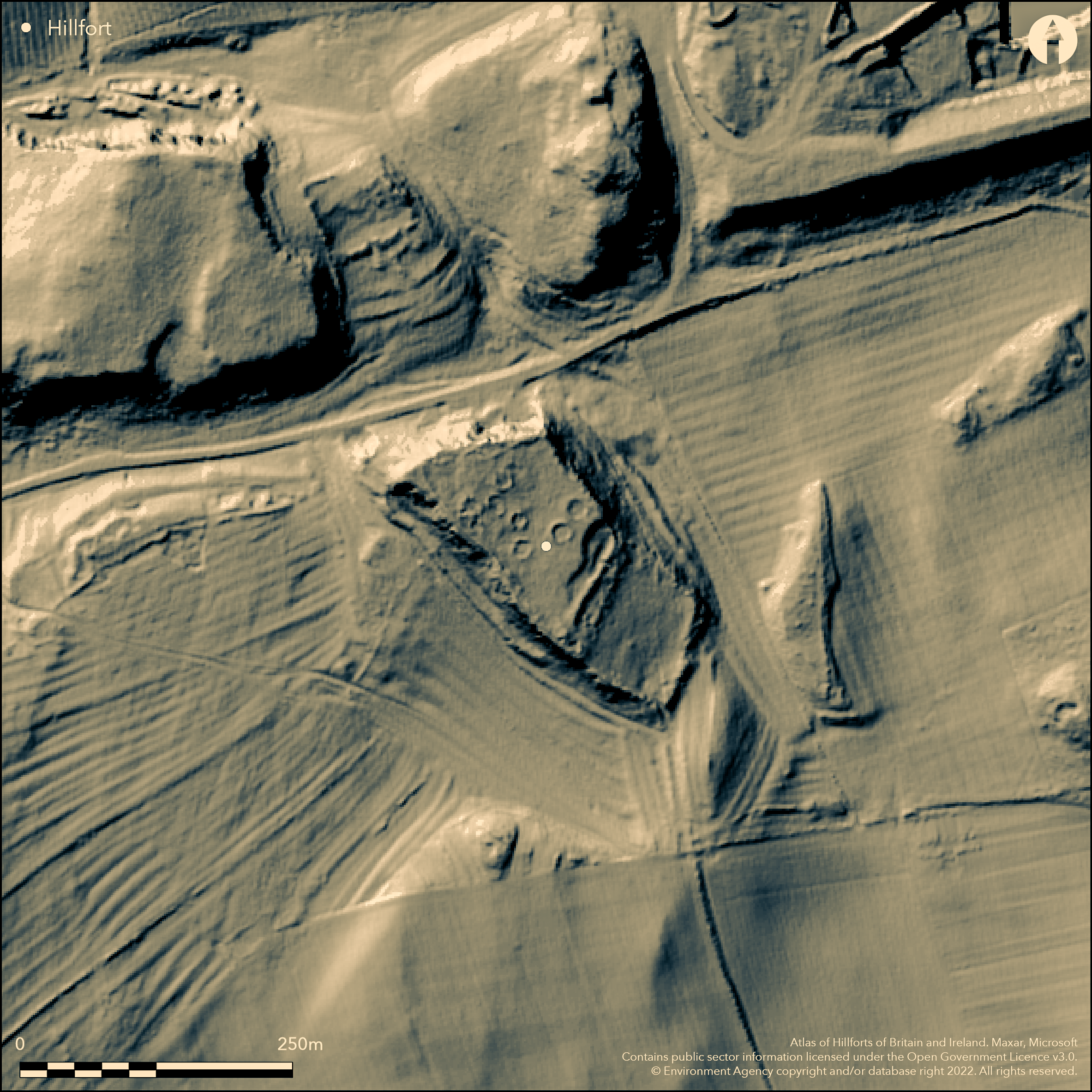
LiDAR 1m DTM Hillshade
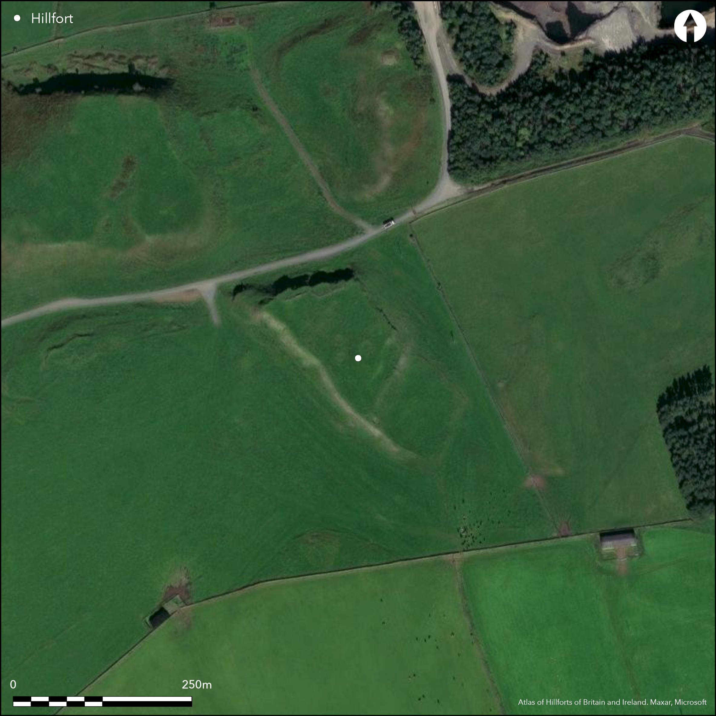
Satellite Imagery
LiDAR 1m DTM Hillshade
Satellite Imagery
Scroll left/right to view further images.
HER: Northumberland 9202 (None)
NMR: NY 97 NW 23 (18947)
SM: 1011403
NGR: NY 94642 76088
X: 394642 Y: 576088 (OSGB36)
To the NW of Colwell, a possible late Iron Age hillfort or early Romano-British settlement occupying a wedge-shaped outlier of the Whin Sill crags at 170m OD. The enclosure measures 192m NW-SE by 70m transversely. An earth and stone rampart 5m wide and 1m high borders the outcrop on all sides, but has now been lost in the N to quarrying. No ditches. A simple gap entrance lies in the SW angle of the ramparts. Two substantial natural outcrops at the foot of the Crags and in the E and W would have provided additional defence. Internally a double stone wall divided the larger enclosure into two compartments with the one in the NW enclosing approximately 0.64ha and in the SE 0.31ha. Within the larger, NW compartment 12 stone founded hut circles 6.5m in diameter survive up to 0.5m high. The SE appears to have been uninhabited and has been interpreted as a stock enclosure (annex). Excavations of nine of the huts in 1924-5 (Ball 1927) produced quernstones, whetstones, a cup marked stone and a piece of medieval pottery. The site is recorded on 1856-65 OS mapping. RCHME field investigations were carried out in 1961 and 1967 and the site is scheduled.
Citizen Science: ✗
Reliability of Data: Confirmed
Reliability of Interpretation: Confirmed
X: -232152 Y: 7377260 (EPSG: 3857)
Longitude: -2.085456645962567 Latitude: 55.07923793400423 (EPSG:4326)
Country: England
Current County or Unitary Authority: Northumberland
Historic County: Northumberland
Current Parish/Community/Council/Townland: Chollerton
Rampart destroyed in the N
| Extant | ✓ |
| Cropmark | ✗ |
| Likely Destroyed | ✗ |
None
| Woodland | ✗ |
| Commercial Forestry Plantation | ✗ |
| Parkland | ✗ |
| Pasture (Grazing) | ✓ |
| Arable | ✗ |
| Scrub/Bracken | ✗ |
| Bare Outcrop | ✗ |
| Heather/Moorland | ✗ |
| Heath | ✗ |
| Built-up | ✗ |
| Coastal Grassland | ✗ |
| Other | ✗ |
A hillslope fort lying at 170m OD on a sloping outcrop of the Whin Sill
| Contour Fort | ✗ |
| Partial Contour Fort | ✗ |
| Promontory Fort | ✗ |
| Hillslope Fort | ✓ |
| Level Terrain Fort | ✗ |
| Marsh Fort | ✗ |
| Multiple Enclosure Fort | ✗ |
| Hilltop | ✗ |
| Coastal Promontory | ✗ |
| Inland Promontory | ✗ |
| Valley Bottom | ✗ |
| Knoll/Hillock/Outcrop | ✗ |
| Ridge | ✗ |
| Cliff/Plateau-edge/Scarp | ✗ |
| Hillslope | ✓ |
| Lowland | ✗ |
| Spur | ✗ |
Dominant Topographic Feature: Outcrop of Whin Sill
| North | ✗ |
| Northeast | ✗ |
| East | ✗ |
| Southeast | ✓ |
| South | ✗ |
| Southwest | ✗ |
| West | ✗ |
| Northwest | ✗ |
| Level | ✗ |
Altitude: 170.0m
N/A
Quernstones and whetstones suggest Iron Age and/or Romano-British use of the site, the cup marked stone indicate the site was of some significance before that. Medieval pottery supports a later reuse of the houses
Reliability: B - Medium
| Pre 1200BC | ✗ |
| 1200BC - 800BC | ✗ |
| 800BC - 400BC | ✓ |
| 400BC - AD50 | ✓ |
| AD50 - AD400 | ✓ |
| AD400 - AD 800 | ✗ |
| Post AD800 | ✗ |
| Unknown | ✗ |
| Pre Hillfort: | None |
| Post Hillfort: | None |
| Artefactual: | None |
Recorded on 1856-65 OS mapping. General reference in MacLauchlan (1852). Several of the hut circles were excavated in 1924-25. Field investigations in 1961 and 1967. Scheduled
| 1st Identified Written Reference (1852): | None |
| Other (1954): | Scheduled |
| Other (1961): | Field investigation |
| Other (1967): | Field investigation |
| 1st Identified Map Depiction (None): | None |
| Excavation (None): | (Ball, 1927) |
Internally a double stone wall divided the larger enclosure into two compartments with the one in the NW enclosing approximately 0.64ha and in the SE 0.31ha. Within the larger compartment, 12 stone founded hut circles 6.5m in diameter survive up to 0.5m high. Excavations of nine of the huts in 1924-5 (Ball 1927) produced quernstones, whetstones, a cup marked stone and a piece of medieval pottery. The SE appears to have been uninhabited
None
| None | ✓ |
| Spring | ✗ |
| Stream | ✗ |
| Pool | ✗ |
| Flush | ✗ |
| Well | ✗ |
| Other | ✗ |
Stone wall
| No Known Features | ✗ |
| Round Stone Structures | ✓ |
| Rectangular Stone Structures | ✗ |
| Curvilinear Platforms | ✗ |
| Other Roundhouse Evidence | ✗ |
| Pits | ✗ |
| Quarry Hollows | ✗ |
| Other | ✓ |
None
| No Known Excavation | ✗ |
| Pits | ✗ |
| Postholes | ✗ |
| Roundhouses | ✓ |
| Rectangular Structures | ✗ |
| Roads/Tracks | ✗ |
| Quarry Hollows | ✗ |
| Other | ✗ |
| Nothing Found | ✗ |
None
| No Known Geophysics | ✓ |
| Pits | ✗ |
| Roundhouses | ✗ |
| Rectangular Structures | ✗ |
| Roads/Tracks | ✗ |
| Quarry Hollows | ✗ |
| Other | ✗ |
| Nothing Found | ✗ |
Quernstones, whetstones, medieval pottery
| No Known Finds | ✗ |
| Pottery | ✓ |
| Metal | ✗ |
| Metalworking | ✗ |
| Human Bones | ✗ |
| Animal Bones | ✗ |
| Lithics | ✗ |
| Environmental | ✗ |
| Other | ✓ |
NO APPARENT FEATURES
| APs Not Checked | ✓ |
| None | ✗ |
| Roundhouses | ✗ |
| Rectangular Structures | ✗ |
| Pits | ✗ |
| Postholes | ✗ |
| Roads/Tracks | ✗ |
| Other | ✗ |
Simple gap entrance lies in the SW angle of the ramparts
| 1: | None |
| 2: | None |
Guard Chambers: ✗
Chevaux de Frise: ✗
| 1. Simple Gap (South west): | None |
The enclosure measures 192m NW-SE by 70m transversely. An earth and stone rampart 5m wide and 1m high borders the outcrop on all sides, but has now been lost in the N to quarrying. No ditches are recorded.
| Area 1: | 0.64ha. |
| Area 2: | 0.31ha. |
| Total: | 0.64ha. |
Total Footprint Area: 1.4ha.
None
| ✗ | Divided internally into two compartments with internal areas of 0.64m and 0.31m. The smaller enclosure is possibly an annex. Measurements have been calculated from satellite imagery |
| ✓ | Rampart destroyed in the N |
| NE Quadrant: | 1 |
| SE Quadrant: | 1 |
| SW Quadrant: | 1 |
| NW Quadrant: | 1 |
| Total: | 1 |
| Partial Univallate | ✗ |
| Univallate | ✓ |
| Partial Bivallate | ✗ |
| Bivallate | ✗ |
| Partial Multivallate | ✗ |
| Multivallate | ✗ |
| Unknown | ✗ |
| Partial Univallate | ✗ |
| Univallate | ✗ |
| Partial Bivallate | ✗ |
| Bivallate | ✗ |
| Partial Multivallate | ✗ |
| Multivallate | ✗ |
None
| None | ✗ |
| Earthen Bank | ✓ |
| Stone Wall | ✗ |
| Rubble | ✓ |
| Wall-walk | ✗ |
| Evidence of Timber | ✗ |
| Vitrification | ✗ |
| Other Burning | ✗ |
| Palisade | ✗ |
| Counter Scarp Bank | ✗ |
| Berm | ✗ |
| Unfinished | ✗ |
| Other | ✗ |
Interior only excavated
| None | ✗ |
| Earthen Bank | ✗ |
| Stone Wall | ✗ |
| Murus Duplex | ✗ |
| Timber-framed | ✗ |
| Timber-laced | ✗ |
| Vitrification | ✗ |
| Other Burning | ✗ |
| Palisade | ✗ |
| Counter Scarp Bank | ✗ |
| Berm | ✗ |
| Unfinished | ✗ |
| No Known Excavation | ✓ |
| Other | ✗ |
| ✗ | None |
| ✗ | None |
Number of Ditches: 0
| ✓ | The SE enclosure may be an annex of 0.31ha, possibly for stock |
Ball, T. 1927. Blue Crag Promontory Fort, Colwell, Northumberland. Proc Soc Antiq Newcastle 4 ser 2, 23-24
MacLauchlan, H. 1852. Memoir written during a survey of the Watling Street (Alnwick), 25
Atlas of Hillforts:
Wikidata:
This work is licensed under CC BY-SA 4.0

 and should be cited as:
Lock, Gary and Ralston, Ian. 2024. Atlas of Hillforts of Britain and Ireland. Available at: https://hillforts.arch.ox.ac.uk
Document Version 1.1