LiDAR 1m DTM Hillshade
Satellite Imagery
LiDAR 1m DTM Hillshade
Satellite Imagery
Scroll left/right to view further images.
HER: Northumberland 3800 (None)
NMR: NU 03 SW 23 (6307)
SM: 1006585
NGR: NU 01357 32819
X: 401357 Y: 632819 (OSGB36)
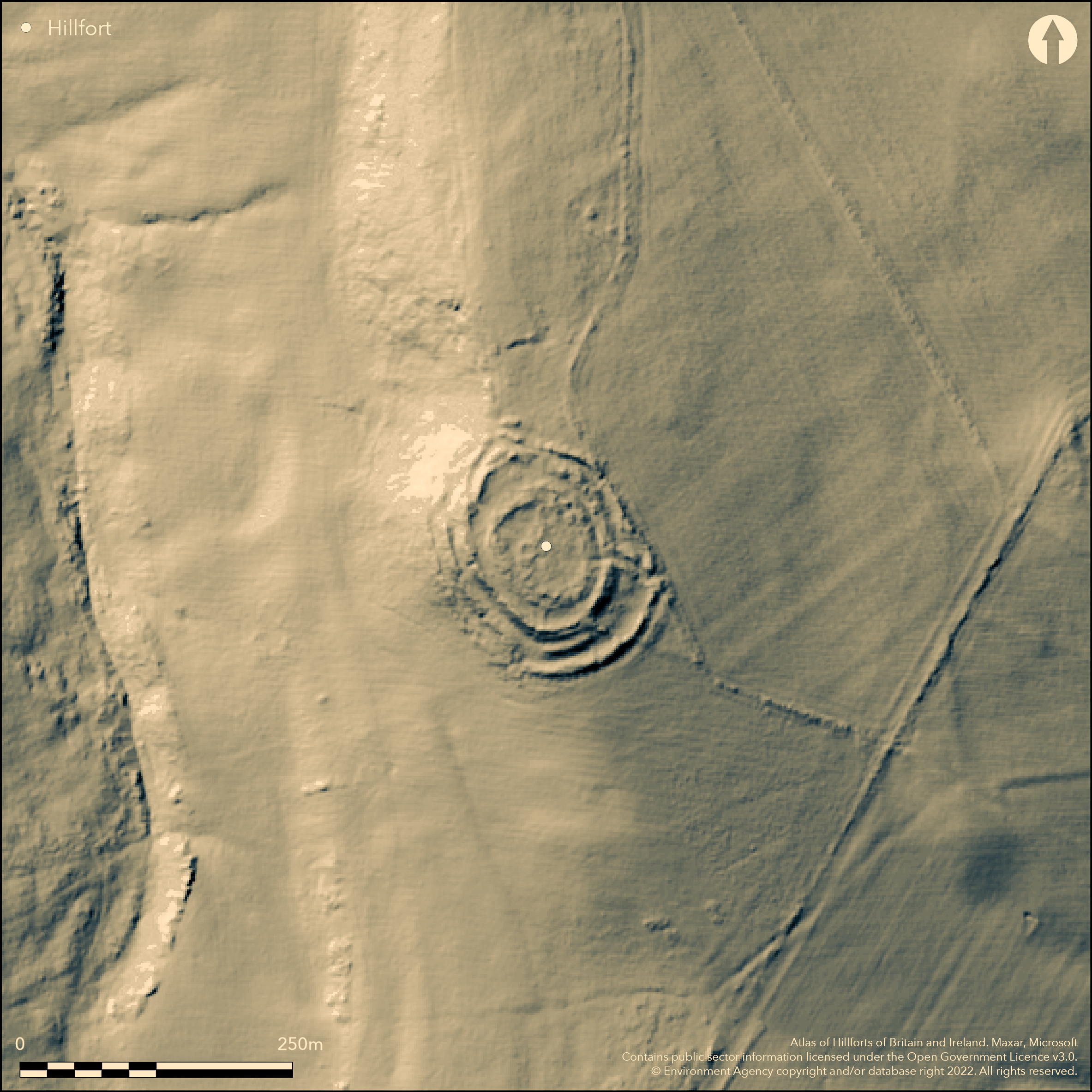
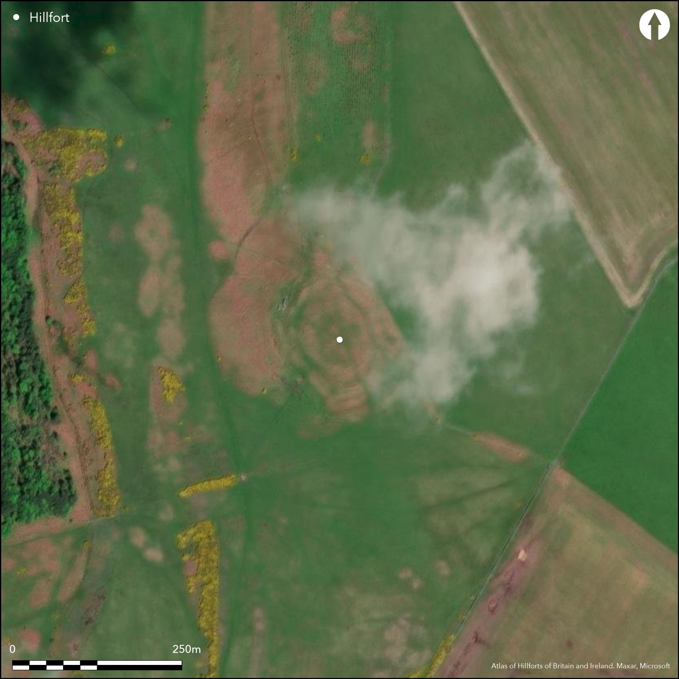
A well-preserved, multivallate hillfort lying below the summit of a hill on Doddington Moor. Approximately oval in form, 55m by 48m, enclosed by up to four earth and stone ramparts and a possible ditch with counterscarp bank in the S. It lies at 154m OD at the edge of an escarpment which slopes away steeply in the W but with gradual slopes elsewhere. The enclosed area measures approximately 0.3ha and is surrounded by a bank 3-5m wide with a maximum height of 0.6m. The middle and outer banks measure 6-8m wide and average 1.5m and 0.6-2.5m wide respectively reaching their maximum height in the W where they are exaggerated by the natural scarp. Spaces between the two outer banks are sufficient for embanked divisions in the N and S, which have been interpreted as stock enclosures. A fourth rampart lies on the western side 5m wide and 0.3m high internally and 2m externally. Slight traces of a ditch 8m wide and 0.3m deep and a counterscarp bank, reported by Hogg (1947) on the S side of the hillfort could not be identified during a RCHME field investigation visit in 1964. An entrance lies in the SE facing gently sloping ground where the ramparts are widely spaced. A passage is formed by two transverse banks between the middle and outer ramparts, which is suggested by Hogg (ibid.), to give the effect of a barbican. Four further breaks in the ramparts are probably not original. Internally there is a narrower stony bank, possibly the foundations of a later wall which runs concentrically to the inner enclosure bank. Within this there are at least five hut circles 3.5-10m in diameter, two are linked by a low wall probably representing later Roman-British occupation. A curving length of bank 4-5m wide and 0.3-0.7 high appended externally to the N of the outer rampart is a possible annex. The hillfort survives in reasonably good condition, although the inner rampart is now mutilated. The site is recorded on 1856-65 OS mapping. No known investigations but presumed Iron Age based on morphology. Scheduled.
Citizen Science: ✗
Reliability of Data: Confirmed
Reliability of Interpretation: Confirmed
X: -220415 Y: 7477037 (EPSG: 3857)
Longitude: -1.980021850884341 Latitude: 55.5890422789156 (EPSG:4326)
Country: England; None
Current County or Unitary Authority: Northumberland
Historic County: Northumberland
Current Parish/Community/Council/Townland: Doddington; Chatton
None
| Extant | ✓ |
| Cropmark | ✗ |
| Likely Destroyed | ✗ |
None
| Woodland | ✗ |
| Commercial Forestry Plantation | ✗ |
| Parkland | ✗ |
| Pasture (Grazing) | ✗ |
| Arable | ✗ |
| Scrub/Bracken | ✓ |
| Bare Outcrop | ✗ |
| Heather/Moorland | ✓ |
| Heath | ✗ |
| Built-up | ✗ |
| Coastal Grassland | ✗ |
| Other | ✗ |
Occupying a shoulder position at 154m OD at the edge of an escarpment which slopes away steeply in the W but with gradual slopes elsewhere. The outer rampart follows the contours in the W and NW
| Contour Fort | ✗ |
| Partial Contour Fort | ✓ |
| Promontory Fort | ✗ |
| Hillslope Fort | ✗ |
| Level Terrain Fort | ✗ |
| Marsh Fort | ✗ |
| Multiple Enclosure Fort | ✗ |
| Hilltop | ✓ |
| Coastal Promontory | ✗ |
| Inland Promontory | ✗ |
| Valley Bottom | ✗ |
| Knoll/Hillock/Outcrop | ✗ |
| Ridge | ✗ |
| Cliff/Plateau-edge/Scarp | ✓ |
| Hillslope | ✓ |
| Lowland | ✗ |
| Spur | ✗ |
Dominant Topographic Feature: Westerly facing escarpment
| North | ✗ |
| Northeast | ✗ |
| East | ✗ |
| Southeast | ✗ |
| South | ✗ |
| Southwest | ✗ |
| West | ✓ |
| Northwest | ✗ |
| Level | ✗ |
Altitude: 154.0m
Boundary between Doddington and Chatton lies 180m to the E
Boundary Type: Parish/Townland
Undated, presumed Iron Age with overlying Romano-British settlement
Reliability: D - None
| Pre 1200BC | ✗ |
| 1200BC - 800BC | ✗ |
| 800BC - 400BC | ✗ |
| 400BC - AD50 | ✗ |
| AD50 - AD400 | ✗ |
| AD400 - AD 800 | ✗ |
| Post AD800 | ✗ |
| Unknown | ✓ |
| Pre Hillfort: | None |
| Post Hillfort: | Romano-British settlement |
| Morphology/Earthwork/Typology: | None |
Recorded on 1856-65 OS mapping. General reference in Tate (1863-9, 149). Field investigations in 1955, 1964 and 1968. Scheduled
| Other (1932): | Scheduled |
| Other (1955): | Field investigation |
| Other (1964): | Field investigation |
| Other (1968): | Field investigation |
| 1st Identified Map Depiction (None): | None |
| 1st Identified Written Reference (None): | None |
Internally there is a narrower stony bank, possibly the foundations of a later wall which runs concentrically to the inner enclosure bank. Within this there are at least five hut circles 3.5-10m in diameter two are linked by a low wall.
Spring 200m to the NW
| None | ✓ |
| Spring | ✗ |
| Stream | ✗ |
| Pool | ✗ |
| Flush | ✗ |
| Well | ✗ |
| Other | ✗ |
Inner stony enclosure wall, hut circles and other divisions
| No Known Features | ✗ |
| Round Stone Structures | ✓ |
| Rectangular Stone Structures | ✗ |
| Curvilinear Platforms | ✗ |
| Other Roundhouse Evidence | ✗ |
| Pits | ✗ |
| Quarry Hollows | ✗ |
| Other | ✓ |
None
| No Known Excavation | ✓ |
| Pits | ✗ |
| Postholes | ✗ |
| Roundhouses | ✗ |
| Rectangular Structures | ✗ |
| Roads/Tracks | ✗ |
| Quarry Hollows | ✗ |
| Other | ✗ |
| Nothing Found | ✗ |
None
| No Known Geophysics | ✓ |
| Pits | ✗ |
| Roundhouses | ✗ |
| Rectangular Structures | ✗ |
| Roads/Tracks | ✗ |
| Quarry Hollows | ✗ |
| Other | ✗ |
| Nothing Found | ✗ |
None
| No Known Finds | ✓ |
| Pottery | ✗ |
| Metal | ✗ |
| Metalworking | ✗ |
| Human Bones | ✗ |
| Animal Bones | ✗ |
| Lithics | ✗ |
| Environmental | ✗ |
| Other | ✗ |
None
| APs Not Checked | ✓ |
| None | ✗ |
| Roundhouses | ✗ |
| Rectangular Structures | ✗ |
| Pits | ✗ |
| Postholes | ✗ |
| Roads/Tracks | ✗ |
| Other | ✗ |
Entrance in the SE facing gently sloping ground where the ramparts are widely spaced. A passage is formed by two transverse banks between the middle and outer ramparts, which are suggested by Hogg (1947), to give the effect of a barbican. Four further breaks in the ramparts are probably not original.
| 5: | None |
| 2: | None |
Guard Chambers: ✗
Chevaux de Frise: ✗
| 1. Oblique (South east): | Middle rampart |
| 2. Oblique (South east): | Outer rampart |
Multivallate and oval in form. Enclosed area surrounded by a bank 55m by 48m, 3-5m wide with a maximum height of 0.6m. The middle and outer banks measure 6-8m wide and average 1.5m and 0.6-2.5m wide respectively. Reaching a maximum height in the W where they are exaggerated by the natural scarp. Spaces between the two outer banks are sufficient for embanked divisions in the N and S, which have been interpreted as stock enclosures. A fourth rampart lies on the western side 5m wide and 0.3m high internally and 2m externally. Slight traces of a ditch 8m wide and 0.3m deep and a counterscarp bank reported by Hogg (1947) on the S side of the hillfort could not be identified during a RCHME field investigation visit in 1964. A narrower stony bank, possibly the foundations of a later wall which runs concentrically to the inner enclosure bank is probably later.
| Area 1: | 0.3ha. |
| Total: | 0.3ha. |
Total Footprint Area: 1.1ha.
None
| ✓ | Whole site footprint estimated from satellite imagery |
| ✗ | A narrower stony bank, running concentrically to the inner enclosure bank is possibly the foundations of a later wall and has not been included in the rampart number |
| NE Quadrant: | 3 |
| SE Quadrant: | 3 |
| SW Quadrant: | 4 |
| NW Quadrant: | 4 |
| Total: | 4 |
| Partial Univallate | ✗ |
| Univallate | ✗ |
| Partial Bivallate | ✗ |
| Bivallate | ✗ |
| Partial Multivallate | ✗ |
| Multivallate | ✓ |
| Unknown | ✗ |
| Partial Univallate | ✗ |
| Univallate | ✗ |
| Partial Bivallate | ✗ |
| Bivallate | ✗ |
| Partial Multivallate | ✗ |
| Multivallate | ✗ |
Counterscarp bank can no longer be seen.
| None | ✗ |
| Earthen Bank | ✓ |
| Stone Wall | ✗ |
| Rubble | ✓ |
| Wall-walk | ✗ |
| Evidence of Timber | ✗ |
| Vitrification | ✗ |
| Other Burning | ✗ |
| Palisade | ✗ |
| Counter Scarp Bank | ✓ |
| Berm | ✗ |
| Unfinished | ✗ |
| Other | ✗ |
None
| None | ✗ |
| Earthen Bank | ✗ |
| Stone Wall | ✗ |
| Murus Duplex | ✗ |
| Timber-framed | ✗ |
| Timber-laced | ✗ |
| Vitrification | ✗ |
| Other Burning | ✗ |
| Palisade | ✗ |
| Counter Scarp Bank | ✗ |
| Berm | ✗ |
| Unfinished | ✗ |
| No Known Excavation | ✓ |
| Other | ✗ |
| ✗ | None |
| ✓ | The ditch can no longer be discerned and is unconfirmed |
Number of Ditches: 1
| ✓ | A curving length of bank 4-5m wide and 0.3-0.7 high appended externally to the N of the outer rampart is a possible annex. |
Tate, G. 1863-9. The Ancient British Sculptured Rocks of Northumberland and the Eastern Borders, with Notices of the Remains Associated with these Sculptures. Hist Berwickshire Natur Club 5, 149.
Hogg, A.H.A. 1947. A new list of the native sites of Northumberland. Proc Soc Antiq Newcastle (4th Series) 11, 157.
Atlas of Hillforts:
Wikidata:
This work is licensed under CC BY-SA 4.0![]()
![]()
![]() and should be cited as:
and should be cited as:
Lock, Gary and Ralston, Ian. 2024. Atlas of Hillforts of Britain and Ireland. Available at: https://hillforts.arch.ox.ac.uk
Document Version 1.1