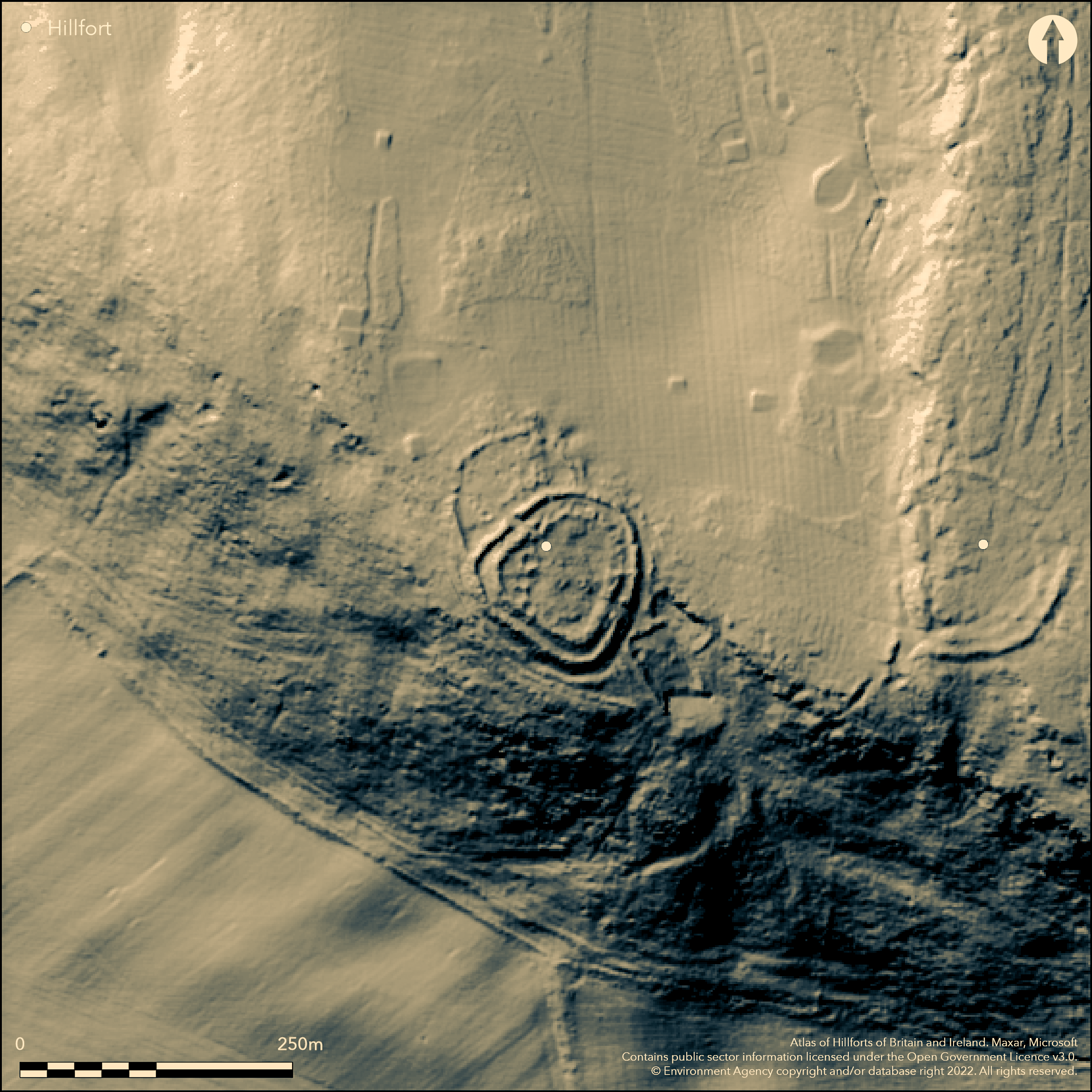
LiDAR 1m DTM Hillshade
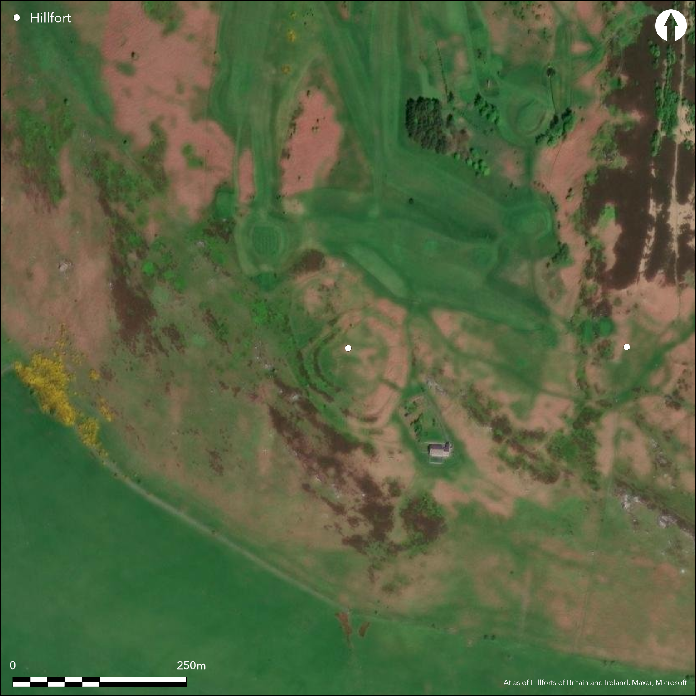
Satellite Imagery
LiDAR 1m DTM Hillshade
Satellite Imagery
Scroll left/right to view further images.
HER: Northumberland 3795 (None)
NMR: NU 03 SW 18 (6272)
SM: 1002946
NGR: NU 00410 31710
X: 400410 Y: 631710 (OSGB36)
An Iron Age bivallate hillfort with annex lying 850m to the SE of Doddington and 110m to the W of Dod Law East (Atlas No. 1932). D-shaped in plan with two earth and stone ramparts which enclose an area of 0.37ha. It is sited at 182m OD on ground which slopes away steeply in the S and SW with good views in most directions, but overlooked by a slight escarpment in the E and NE. The ramparts have been mutilated with the inner rampart 5-7m wide and standing 0.4-3m high and the outer rampart 6-8m wide and 12-2.5m high. A third bank, up to 0.5m high, lies on the southern side of the outward facing scarp and continues along the SW side of the earthwork. Excavation (Smith 1990) showed that the wall of the inner rampart stood approximately 3.2m wide and 1.5m high. There is no evidence of ditches. Entrances lie in the SE and NW. The ramparts at the SE entranceway are inturned, almost to the inner rampart, forming a passageway. In the NW the entrance opens into the annex. Up to ten possible hut circles between 4-8m in diameter and a possible kiln have been recorded within the interior. Two pairs of huts are connected by a slight wall with a central gateway. Where visible their entrances lie in the SE. One of the hut circles excavated in the 1920's was reported to have been well constructed from sandstone (anon. 1923-5). A further hut circle has been recorded outside on the N side. These probably represent Romano-British reuse of the site. The foundations of a rectangular building, probably modern, which has cut into the inner rampart, lies in the E. The single embanked annex ls appended to the outer rampart in the NW comprising a curving bank, 60m SW-NE by 37m transversely, enclosing 1.7ha. The enclosing bank is 3-5m wide and stands 0.5-0.8m high. It has an entrance in the W. Biological remains from the excavations suggests the occupants of the hillfort were producing their own crops and using plants from the moorland and valley bottom. Radiocarbon dates obtained from charred wood, charcoal and wheat chaff from the ramparts (Smith 1990) suggest the hillfort was constructed during the Iron Age in three phases, the earliest being a palisade and outer rampart of dump construction (c.500-200 BC). This was succeeded by a stone inner rampart (2nd century BC) which remained standing until AD 100. Partial destruction of the inner rampart occurred during the construction of the inner revetment of the outer rampart. The site is shown on 1856-65 OS mapping. Cup and ring-marked stones lie in close proximity to this hillfort.
Citizen Science: ✗
Reliability of Data: Confirmed
Reliability of Interpretation: Confirmed
X: -222088 Y: 7475074 (EPSG: 3857)
Longitude: -1.9950480398120776 Latitude: 55.57907891282878 (EPSG:4326)
Country: England
Current County or Unitary Authority: Northumberland
Historic County: Northumberland
Current Parish/Community/Council/Townland: Doddington
Ramparts have been mutilated in places
| Extant | ✓ |
| Cropmark | ✗ |
| Likely Destroyed | ✗ |
None
| Woodland | ✗ |
| Commercial Forestry Plantation | ✗ |
| Parkland | ✗ |
| Pasture (Grazing) | ✗ |
| Arable | ✗ |
| Scrub/Bracken | ✓ |
| Bare Outcrop | ✗ |
| Heather/Moorland | ✗ |
| Heath | ✗ |
| Built-up | ✗ |
| Coastal Grassland | ✗ |
| Other | ✗ |
A contour fort lying on the summit of a south-westerly facing slope of a spur at 182m OD
| Contour Fort | ✓ |
| Partial Contour Fort | ✗ |
| Promontory Fort | ✗ |
| Hillslope Fort | ✗ |
| Level Terrain Fort | ✗ |
| Marsh Fort | ✗ |
| Multiple Enclosure Fort | ✗ |
| Hilltop | ✓ |
| Coastal Promontory | ✗ |
| Inland Promontory | ✗ |
| Valley Bottom | ✗ |
| Knoll/Hillock/Outcrop | ✗ |
| Ridge | ✗ |
| Cliff/Plateau-edge/Scarp | ✓ |
| Hillslope | ✗ |
| Lowland | ✗ |
| Spur | ✓ |
Dominant Topographic Feature: Summit of a spur
| North | ✗ |
| Northeast | ✗ |
| East | ✗ |
| Southeast | ✗ |
| South | ✗ |
| Southwest | ✓ |
| West | ✗ |
| Northwest | ✗ |
| Level | ✗ |
Altitude: 182.0m
N/A
Charcoal from ground surface below inner rampart: terminus post quem (tpq) 400-190 cal BC and 390-170 cal BC; deposit from latest three stages of retaining wall of outer rampart; 200-40 cal BC; deposit built-up against outer rampart: terminus ante quem (taq) for construction 400-200 cal BC; deposit accumulated against latest three stages of retaining wall of outer rampart: 170 cal BC to- cal AD 230; deposit behind outer rampart: 170 cal BC to cal AD 220; deposit built-up against outer rampart: taq for outer rampart construction 90 cal BC-cal AD 320 (Smith 1990). Horn (Forthcoming) suggests the hillfort start 380-210 BC, ends AD 50-100. Finds from excavations included pottery vessels, animal bone, a bronze fibulae, glass bangle, melon bead, quernstones, hammerstones, slag, sling stone.
Reliability: A - High
| Pre 1200BC | ✗ |
| 1200BC - 800BC | ✗ |
| 800BC - 400BC | ✗ |
| 400BC - AD50 | ✓ |
| AD50 - AD400 | ✓ |
| AD400 - AD 800 | ✗ |
| Post AD800 | ✗ |
| Unknown | ✗ |
| Pre Hillfort: | None |
| Post Hillfort: | None |
| Artefactual: | None |
| C14: | 7 radiocarbon dates |
| Morphology/Earthwork/Typology: | None |
The site is shown on 1856-65 OS mapping and recorded by Tate (1863-8). It was excavated in the 1920s (anon. 1923-5) and 1989 (Smith 1990). Field iinvestigations in 1955, 1964, 1968. Scheduled
| Other (1955): | Field iinvestigation |
| Other (1964): | Field iinvestigation |
| Other (1968): | Field iinvestigation |
| 1st Identified Map Depiction (None): | None |
| 1st Identified Written Reference (None): | None |
| Excavation (None): | None |
| Excavation (None): | None |
| Other (None): | Scheduled |
Six confirmed and two possible hut circles between 4-8m in diameter and a possible kiln have been recorded within the interior. Two pairs of huts are connected by a slight wall with a central gateway. Where visible their entrances lie in the SE. The foundations of a rectangular building, probably modern, which has cut into the inner rampart, lies in the E. Range of material culture from excavations.
River Till to the SW
| None | ✓ |
| Spring | ✗ |
| Stream | ✗ |
| Pool | ✗ |
| Flush | ✗ |
| Well | ✗ |
| Other | ✗ |
Huts connected by a slight wall with a central gateway. Foundations of a rectangular building, probably modern
| No Known Features | ✗ |
| Round Stone Structures | ✓ |
| Rectangular Stone Structures | ✓ |
| Curvilinear Platforms | ✗ |
| Other Roundhouse Evidence | ✗ |
| Pits | ✗ |
| Quarry Hollows | ✗ |
| Other | ✓ |
None
| No Known Excavation | ✗ |
| Pits | ✗ |
| Postholes | ✗ |
| Roundhouses | ✓ |
| Rectangular Structures | ✗ |
| Roads/Tracks | ✗ |
| Quarry Hollows | ✗ |
| Other | ✗ |
| Nothing Found | ✗ |
None
| No Known Geophysics | ✓ |
| Pits | ✗ |
| Roundhouses | ✗ |
| Rectangular Structures | ✗ |
| Roads/Tracks | ✗ |
| Quarry Hollows | ✗ |
| Other | ✗ |
| Nothing Found | ✗ |
Glass
| No Known Finds | ✗ |
| Pottery | ✓ |
| Metal | ✓ |
| Metalworking | ✓ |
| Human Bones | ✗ |
| Animal Bones | ✓ |
| Lithics | ✓ |
| Environmental | ✓ |
| Other | ✓ |
None
| APs Not Checked | ✓ |
| None | ✗ |
| Roundhouses | ✗ |
| Rectangular Structures | ✗ |
| Pits | ✗ |
| Postholes | ✗ |
| Roads/Tracks | ✗ |
| Other | ✗ |
Entrances in the SE and NW. The ramparts at the SE entrance are inturned, almost to the inner rampart, forming a passageway. In the NW the entrance opens into an annex. Two other more recent breaks.
| 6: | None |
| 2: | None |
Guard Chambers: ✗
Chevaux de Frise: ✗
| 1. Passage-way/Corridor (South east): | Outer rampart in-turned to inner rampart |
| 1. Simple Gap (South east): | Inner ramparrt |
| 2. Simple Gap (North west): | Inner rampart |
| 2. Simple Gap (North west): | Outer rampart, opens into annex |
Inner rampart 5-7m wide, standing 0.4-3m high and the outer rampart 6-8m wide and 12-2.5m high. A third bank, up to 0.5m high, lies on the southern side of the outward facing scarp which continues along the SW side of the earthwork. Excavation showed that the wall of the inner rampart stood at c. 3.2m wide and c. 1.5m high. No ditches are recorded
| Area 1: | 0.37ha. |
| Total: | 0.37ha. |
Total Footprint Area: 0.89ha.
None
| ✓ | Whole site footprint includes annex. Measurements estimated from satellite imagery. |
| ✓ | Radiocarbon dates (Smith 1990) suggest the hillfort was constructed during the Iron Age in three phases, the earliest being a palisade and outer rampart of dump construction (c.500-200 BC). This was succeeded by a stone inner rampart (2nd century BC) which remained standing until AD 100. Partial destruction of the inner rampart occurred during the construction of the inner revetment of the outer rampart. |
| NE Quadrant: | 2 |
| SE Quadrant: | 2 |
| SW Quadrant: | 3 |
| NW Quadrant: | 2 |
| Total: | 3 |
| Partial Univallate | ✗ |
| Univallate | ✗ |
| Partial Bivallate | ✓ |
| Bivallate | ✗ |
| Partial Multivallate | ✓ |
| Multivallate | ✗ |
| Unknown | ✗ |
| Partial Univallate | ✗ |
| Univallate | ✓ |
| Partial Bivallate | ✗ |
| Bivallate | ✓ |
| Partial Multivallate | ✓ |
| Multivallate | ✗ |
None
| None | ✗ |
| Earthen Bank | ✓ |
| Stone Wall | ✗ |
| Rubble | ✗ |
| Wall-walk | ✗ |
| Evidence of Timber | ✗ |
| Vitrification | ✗ |
| Other Burning | ✗ |
| Palisade | ✗ |
| Counter Scarp Bank | ✗ |
| Berm | ✗ |
| Unfinished | ✗ |
| Other | ✗ |
None
| None | ✗ |
| Earthen Bank | ✓ |
| Stone Wall | ✓ |
| Murus Duplex | ✗ |
| Timber-framed | ✗ |
| Timber-laced | ✗ |
| Vitrification | ✗ |
| Other Burning | ✗ |
| Palisade | ✓ |
| Counter Scarp Bank | ✗ |
| Berm | ✗ |
| Unfinished | ✗ |
| No Known Excavation | ✗ |
| Other | ✗ |
| ✗ | None |
| ✗ | No ditches are recorded |
Number of Ditches: None
| ✓ | A single embanked annex appended to the outer rampart in the NW comprises a curving bank 60m SW-NE by 37m transversely, enclosing 1.7ha (measurements taken from satellite imagery). A gap in the W is possibly an entrance. |
Anon. 1923-5 Hist Berwick Nat Club 25 1923-5, 204-5 (Report of Meeting)
Horn, J. Forthcoming. The dating of hillforts in Britain and Ireland. Unpublished PhD thesis, University of Edinburgh.
Jobey G. 1965, Hillforts and settlements in Northumberland, Arch. Aeliana (4th Series) 43. No. 35, 61
Maddison M. & Sellers P. 1990, A survey of Doddington and Horton Moors, Northumberland. Northern Arch. vol. 10. 29-76
Smith, C.1990 Excavations at Dod Law West hillfort, Northumberland. Northern Archaeol 9, 1-55
Atlas of Hillforts:
Wikidata:
This work is licensed under CC BY-SA 4.0

 and should be cited as:
Lock, Gary and Ralston, Ian. 2024. Atlas of Hillforts of Britain and Ireland. Available at: https://hillforts.arch.ox.ac.uk
Document Version 1.1